August 19 , 2024.
Kamchatka , Sheveluch :
VOLCANO OBSERVATORY NOTICE FOR AVIATION (VONA)
Issued: August 18 , 2024
Volcano: Sheveluch (CAVW #300270)
Current aviation colour code: RED
Previous aviation colour code: red
Source: KVERT
Notice Number: 2024-57
Volcano Location: N 56 deg 38 min E 161 deg 18 min
Area: Kamchatka, Russia
Summit Elevation: 3283 m (10768.24 ft), the dome elevation ~2500 m (8200 ft)
Volcanic Activity Summary:
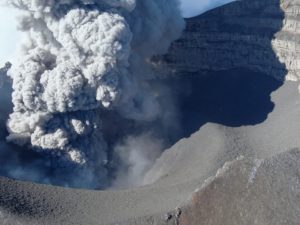
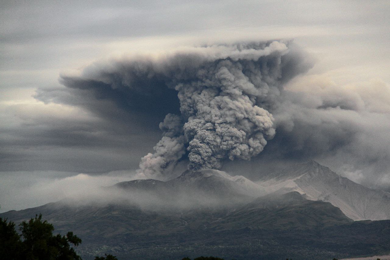
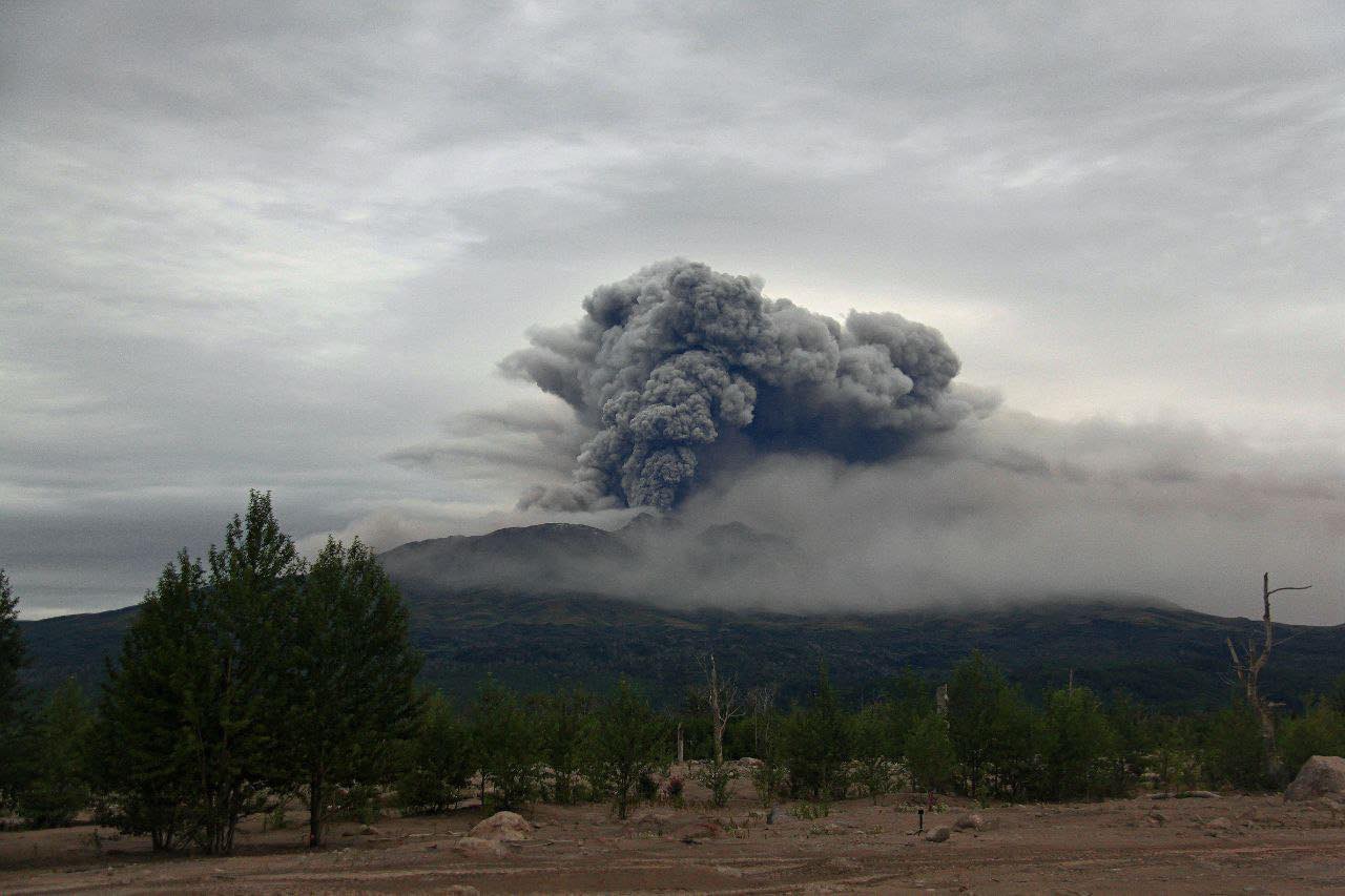
An explosive eruption of the lava dome 300 years RAS of the Sheveluch volcano continues. Explosions sent ash up to 4.5-5 km a.s.l., and ash plume extended about 1520 km to the east-south-east from the volcano.
An explosive eruption of Sheveluch volcano continues. The danger of ash explosions up to 10 km (32,800 ft) a.s.l. remains. Ongoing activity could affect international and low-flying aircraft.
Volcanic cloud height:
4000-4500 m (13120-14760 ft) AMSL Time and method of ash plume/cloud height determination: 20240818/0530Z – Video data
Other volcanic cloud information:
Distance of ash plume/cloud of the volcano: 1520 km (945 mi)
Direction of drift of ash plume/cloud of the volcano: ESE / azimuth 110 deg
Time and method of ash plume/cloud determination: 20240818/0500Z – Himawari-9 14m15
Start time of explosion and how determined: 20240817/1145Z – Satellite data
VOLCANO OBSERVATORY NOTICE FOR AVIATION (VONA)
Issued: August 19 , 2024
Current aviation colour code: ORANGE
Volcanic Activity Summary:
The explosive eruption of the volcano probably ended, but extrusive eruptions from the two centers near the Karan lava dome (the lava domes 300 years of the RAS and a New) continues. Clouds obscured the volcano at now. Satellite data by KVERT shows a 1900 long ash cloud continues to drift to the east of the volcano, its front part at 19:20 UTS on 18 August was at a distance of more than 2400 km from the volcano. KVERT continues to monitor of the Sheveluch volcano.
An extrusive eruption of Sheveluch volcano continues. The danger of ash explosions up to 10 km (32,800 ft) a.s.l. remains. Ongoing activity could affect international and low-flying aircraft.
Source : KVERT
Photo : Viktor Frolov IVS FEB RAS , Viktor Frolov , Institut de volcanologie et de sismologie DVO RAN, @IViS_DVO_RAN
Indonesia , Tangkuban Parahu :
Information about volcanic ash and gas from Mount Tangkuban Parahu.
Tangkuban Parahu Volcano is an active volcano located in West Bandung Regency and Subang Regency, West Java Province. This volcano has 9 craters, the two main craters of which are in the summit area, namely Kawah Ratu and Crater Upas.
The latest eruptive activity of Mount Tangkuban Parahu in 2019 began with a phreatic eruption of Kawah Ratu, namely on July 26, 2019 at 15:48 WIB, there was a phreatic eruption at Kawah Ratu, as well as the increase in the level of eruptive activity which was quite significant, therefore since August 2, 2019 at 08:00 WIB, the activity level of Mount Tangkuban Parahu has been raised to level II (Waspada). After undergoing an eruption phase for almost 3 months, volcanic activity decreased significantly, so that the activity level was reduced to level I (normal) again on October 21, 2019 at 09:00 WIB. On August 18, 2024, residents around Mount Tangkuban Parahu reported that volcanic ash was coming out of the crater, causing eye pain.
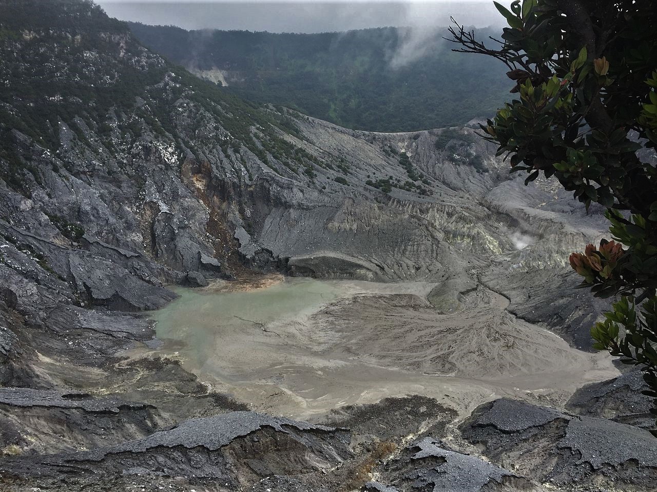
So far, the volcanic activity level of Mount Tangkuban Parahu is still at Level I (normal), characterized by the white smoke emission activity of Kawah Ratu with light to thick intensity, with a height of 5 to 150 m above the Stepped Crater and 5 to 175 m at the bottom of the Ecoma Crater. No volcanic ash has been observed around the Ratu Crater. Seismicity records from January to August 18, 2024 show that there were less than 5 seismic tremors per day, and volcanic earthquakes associated with magma input were very rarely recorded, and no eruption seismic events were recorded. The results of deformation measurements using an inclinometer and electronic distance measuring (EDM) equipment indicate that there is relative inflation in the UPAS segment and there is no deformation change pattern in the SLOPE segment.
Based on the results of multigas measurements located south of the Ratu crater rim with measurement periods every 6 hours/day (00:00, 06:00, 12:00, 18:00 WIB), gas measurements for the period from 12 to 18 August 2024 are under normal conditions with measured gas concentrations for CO2: 410-435 ppm (threshold 5000 ppm), H2S: 0.1-3.5 ppm (threshold 10-15 ppm) and SO2 < 0.1 ppm (threshold 5 ppm). Neither the gas concentration nor the gas ratio show an upward trend, the conditions are just fluctuating. However, since the gas measurement locations are different between the station location and the visitor location, the gas concentration data from the multigas (South) cannot describe the gas concentration data coming towards the visitors (Southeast). If the visitors feel pain in their eyes, it is possible that at that time the gases from the crater are heading towards the visitor. And since the visitor has been there for a long time, it may cause eye irritation. However, it really depends on the immune status of each person/visitor. Exposure to volcanic gases is greatly influenced by the wind direction and speed around the crater.
Currently, the activity level of Mt. Tangkuban Parahu is considered to be still at Level I (normal),
Source : PVMBG
Photo : Adri45an ( 02/2024)
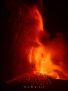
Ecuador , Reventador :
DAILY REPORT ON THE STATE OF THE REVENTADOR VOLCANO, Sunday, August 18, 2024.
Information Geophysical Institute – EPN.
Surface Activity Level: High, Surface Trend: No Change
Internal Activity Level: Moderate, Internal Trend: No Change
From August 17, 2024, 11:00 a.m. to August 18, 2024, 11:00 a.m.:
Seismicity:
Below is the count of seismic events recorded at the reference station
Explosion (EXP): 43
Rainfall/Lahars:
Yesterday afternoon, according to external reports, moderate rains were recorded in the area of the volcano and its surroundings, without these being able to generate mud and debris flows. In the event of heavy rains, these could remobilize the accumulated materials, generating mud and debris flows that would descend the sides of the volcano and flow into adjacent rivers.
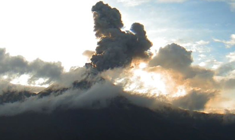
Emissions/ash column:
Since yesterday, thanks to the monitoring of the GOES-16 satellite system, very few episodes of gas or ash emissions have been observed, with heights of up to 800 m above the crater level in a northwesterly direction. Regarding this activity, the VAAC agency in Washington has published 2 reports on ash emissions, at 710 m above the crater level in a northwesterly direction.
Other monitoring parameters:
During the last 24 hours, the MIROVA-MODIS satellite system detected 1 moderate thermal anomaly, 1 weak thermal anomaly.
Observation:
Monitoring of satellite images, weather forecast services and external reports indicates that the volcano remained cloudy or partly clear most of the time. Similarly, during the afternoon and night, several thermal anomalies located in the crater area were detected on satellite images.
Alert level: Orange
Source : IGEPN.
Photo : IGEPN ( archive)
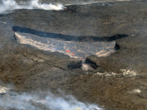
Hawaii , Kilauea :
Sunday, August 18, 2024, 9:10 AM HST (Sunday, August 18, 2024, 19:10 UTC)
19°25’16 » N 155°17’13 » W,
Summit Elevation 4091 ft (1247 m)
Current Volcano Alert Level: ADVISORY
Current Aviation Color Code: YELLOW
Activity Summary:
Kīlauea is not erupting. Low rates of seismicity continue at the summit with low to moderate seismicity occurring in the upper and middle East Rift Zone. Inflationary ground deformation in the summit and middle East Rift Zone continues. New seismic swarms may occur with little or no warning and result in either intrusion of magma or eruption of lava in these regions. There are no significant changes in activity in the lower East Rift Zone and Southwest Rift Zone of the volcano.
Summit Observations:
Approximately 24 earthquakes were detected beneath Kaluapele (Kīlauea’s summit caldera) over the past 24 hours. Most were located beneath and to the south of Halema‘uma‘u at depths of 1–3 km (0.6–1.9 mi) below the ground surface with magnitudes of less than M2.0. There has been a slight increase in the rate of deformation recorded by summit tiltmeters at Sandhill (SDH) and Uēkahuna (UWE). The gradual inflationary trend is also seen on GPS instruments around the summit region. The most recent measurement of the summit’s SO2 emission rate was approximately 70 tonnes per day on August 13, 2024.
Rift Zone Observations:
Approximately 30 earthquakes were detected beneath the upper East Rift Zone (UERZ) over the past 24 hours, most of which were located between Puhimau Crater and Koʻokoʻolau Crater. All had magnitudes below M2.0 and depths ranged from 1–3 km (0.6–1.9 mi) below the ground surface. The ESC tiltmeter in the UERZ has recorded no significant changes over the past day.
Approximately 11 earthquakes were detected beneath the middle East Rift Zone (MERZ) between Maunaulu and Puʻuʻōʻō within Hawaiʻi Volcanoes National Park. Most occurred just west of Kānenuiohamo and Makaopuhi Crater at depths of 1–4 km (0.6–2.5 mi) below the ground surface and magnitudes less than M2.5. Inflation recorded by the POC tiltmeter, located on the north flank of Puʻuʻōʻō, has slowed significantly in the past day. HVO released an Information Statement on August 8 summarizing recent activity, interpretations, and possible scenarios associated with recent activity in the MERZ.
Measurements from continuous gas monitoring stations downwind of Puʻuʻōʻō in the middle East Rift Zone—the site of 1983–2018 eruptive activity—remain below detection limits for SO2, indicating that SO2 emissions from this area are negligible.
At this time, there is no evidence of seismicity or ground deformation beneath the lower East Rift Zone, and Southwest Rift Zone activity remains low.
Source : HVO
Photo : USGS / M. Patrick. (07/2024)
Costa Rica , Rincon de la Vieja / Poas :
Rincon de la Vieja Volcano
The volcano is downgraded from caution to warning (OVSICORI volcanic activity scale).
This week, 7 exhalations and 5 eruptions rich in water vapor, aerosols and volcanic gases were recorded. None of these generated lahars or ash descent. Although eruptive activity continues, the acoustic energy of recent eruptions (during this year) does not reach the levels of April to June 2023, where at least 5 of these events generated the descent of hot lahars. The sequence of banded tremors that began on July 25 remains intermittent until today. These tremor episodes are variable in amplitude, dominant frequency and duration. Tremor in general is variable, where it can be fragmented, continuous or of very low amplitude.
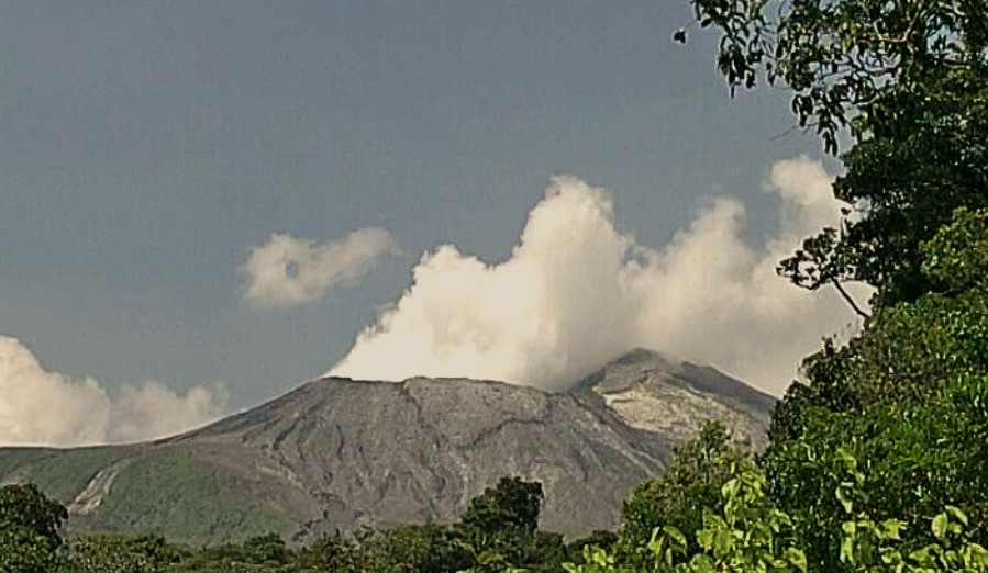
Between periods of banded tremor or decrease in the seismic energy of the tremor, exhalations or small eruptions are observed. The sporadic occurrence of long-period signals such as « tornillos » type signals persists. The dominant frequency of « tornillos » type signals showed a slight increase this week, as well as last week. In addition, several low-magnitude distal volcano-tectonic earthquakes were recorded on the southern flank of the volcano (Pailas). In recent weeks, a contraction of the base has been detected without significant vertical and horizontal movement of the summit. The SO2 plume in the atmosphere has not been detected by the Sentinel-5P satellite since June 29. During the previous week, the NOVAC station recorded a flow of 233 ± 119 t/d of SO2, similar to that of the previous week (258 ± 100 t/d). Gas ratios recorded by the MultiGAS station remain stable with weekly averages of 1.60 ± 0.81 for CO2/SO2 and 0.12 ± 0.02 for H2S/SO2.
Poas Volcano
The seismic tremor continues, with a lower amplitude than that observed last week. Almost no acoustic tremor is recorded. Frequent low-frequency, low-amplitude LP-type seismic events are also recorded. Their number fluctuates around a hundred events daily. Short, broad-spectrum tremors continue to be recorded. Over the last week, the crustal contraction of the crater has disappeared as well as the subsidence to the north of the crater and there is no significant vertical movement to the south of the crater. There is therefore no significant deformation on the volcano.
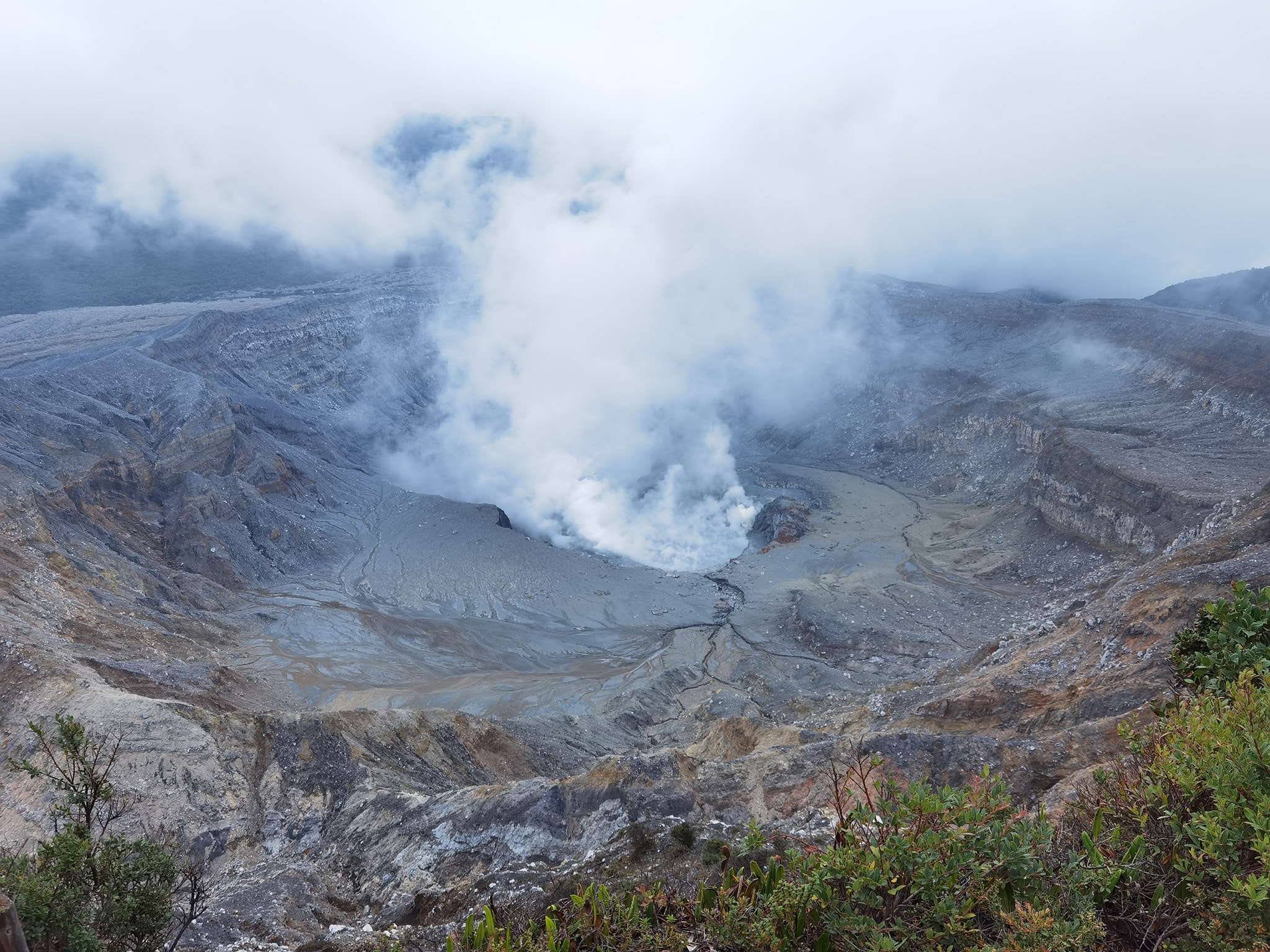
Gas compositions recorded by the MultiGAS station remain stable with weekly averages of 1.7 ± 0.4 for SO2/CO2 remain stable with a weekly average of 0.30 ± 0.05 for H2S/SO2. The SO2 concentration recorded by the ExpoGAS station at Visitor Viewpoint reached a maximum of 3.5 ppm this week. The SO2 plume in the atmosphere has not been detected by the Sentinel-5P satellite since June 20. The lake level shows fluctuations related to heavy rainfall but remains generally stable from day to day.
Source : Ovsicori
Photos : Ovsicori ( 05/2024) , Silvio neels ( 04/2024)