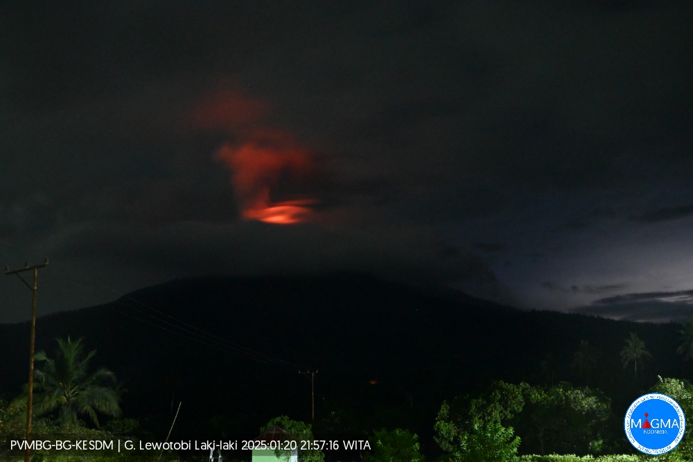
June 7, 2023. EN. Indonesia : Anak Krakatau , Italy / Sicily : Etna , Italy : Stromboli , Colombia : Chiles / Cerro Negro , Iceland : Bárðarbunga .

June 07 , 2023.


Indonesia , Anak Krakatau :

An eruption of Mount Anak Krakatau occurred on Tuesday, June 06, 2023 at 2:34 p.m. WIB with an ash column height observed at ± 500 m above the peak (± 657 m above sea level). The ash column was observed to be gray with a thick intensity, oriented northwest. This eruption was recorded on a seismograph with a maximum amplitude of 46 mm and a duration of 80 seconds.

VOLCANO OBSERVATORY NOTICE FOR AVIATION – VONA

Issued : June 06 , 2023
Volcano : Anak Krakatau (262000)
Current Aviation Colour Code : ORANGE
Previous Aviation Colour Code : orange
Source : Anak Krakatau Volcano Observatory
Notice Number : 2023KRA052
Volcano Location : S 06 deg 06 min 07 sec E 105 deg 25 min 23 sec
Area : Lampung, Indonesia
Summit Elevation : 502 FT (157 M)

Volcanic Activity Summary :
Eruption with volcanic ash cloud at 07h34 UTC (14h34 local).

Volcanic Cloud Height :
Best estimate of ash-cloud top is around 2102 FT (657 M) above sea level or 1600 FT (500 M) above summit. May be higher than what can be observed clearly. Source of height data: ground observer.

Other Volcanic Cloud Information :
Ash cloud moving to northwest. Volcanic ash is observed to be gray. The intensity of volcanic ash is observed to be thick.

Remarks :
Eruption recorded on seismogram with maximum amplitude 46 mm and maximum duration 80 second.

Source : Magma Indonésie.


Italy / Sicily , Etna : 

WEEKLY BULLETIN, from May 29, 2023 to June 04, 2023. (issue date June 06, 2023)

ACTIVITY STATUS SUMMARY

In the light of the monitoring data, it is highlighted:

1) VOLCANOLOGICAL OBSERVATIONS: Degassing activity at the summit craters, in particular continuous degassing at the Bocca Nuova crater (BN) and at the Southeast crater (CSE).
2) SEISMOLOGY: The seismicity of the week was characterized by the occurrence of a swarm of earthquakes which, from 4:24 p.m. (UTC) on June 4, affected the middle western slope of the volcano with a focal volume located at a depth between 16 and about 23 km.
The average amplitude of the volcanic tremor remained at medium-low values throughout the week.
3) INFRASOUNDS: Fairly high rate of occurrence of events, especially in the first three days of the week. The events were mainly located in the area between the Bocca Nuova and Voragine craters and subordinate to the Southeast crater.
4) GROUND DEFORMATIONS: Ground deformation monitoring networks show no significant variations.
5) GEOCHEMISTRY: SO2 flux at medium-low level
CO2 fluxes settle on medium-high outgassing values
There are no updates on the Helium isotope ratio.
The partial pressure of dissolved CO2 does not show any significant variations.
6) SATELLITE OBSERVATIONS: Thermal activity observed by satellite was generally weak to moderate.

VOLCANOLOGICAL OBSERVATIONS
During the week, monitoring of Etna’s activity was carried out through the surveillance cameras of the INGV – Osservatorio Etneo. Throughout the period, sightings were intermittent due to heavy cloud cover.
During the week of observation, the volcanic activity of Etna was characterized by a variable level degassing of the summit craters, in particular the crater of Bocca Nuova (BN), which continued to feed an uninterrupted degassing sometimes pulsating and from the Southeast Crater (CSE), which produced continuous degassing presumably from the eruptive vent of May 21, 2023 and localized fumarolic degassing along the crater rim.
The Northeast Crater (NEC) showed weak degassing from active fumaroles along the crater rim.

Source : INGV.

Photo : Liotta Marisa.


Italy , Stromboli :

WEEKLY BULLETIN, from May 29, 2023 to June 04, 2023. (issue date June 06, 2023)

ACTIVITY STATUS SUMMARY

In the light of the monitoring data, it is highlighted:

1) VOLCANOLOGICAL OBSERVATIONS: During this period, normal Strombolian activity was observed with splashing activity in sector C. The total hourly frequency of explosions fluctuated around average values (7-10 events/h). The intensity of the explosions was mainly low and medium in both the North Crater area and the Center-South Crater area.
2) SEISMOLOGY: The seismological parameters monitored do not show any significant variations.
3) GROUND DEFORMATIONS: Ground deformation monitoring networks show no significant variations.
4) GEOCHEMISTRY: The flow of SO2 is placed at an average level
There are no updates on CO2 flux data in the Pizzo area
There are no C/S data updates in the plume.
There is no update on the isotope ratio of helium in groundwater.
5) SATELLITE OBSERVATIONS: The thermal activity observed from the satellite was generally weak.

VOLCANOLOGICAL OBSERVATIONS
During the observation period, the eruptive activity of Stromboli was characterized by analyzing the images recorded by the INGV-OE surveillance cameras at an altitude of 190 m (SCT-SCV) and the Pizzo sopra la Fossa (SPT). The explosive activity was mainly produced by two eruptive vents located in the North zone of the crater and by five vents located in the Center-South zone.
Due to the unfavorable weather conditions of June 2, the visibility of the crater area was insufficient for a correct description of the eruptive activity.

Observations of explosive activity captured by surveillance cameras
In the northern zone of the crater (N), characterized by a vent located in the N1 sector and one in the N2 sector, an explosive activity was observed of variable intensity from low (the eruptive products reached a height of less than 80 m ) to medium (eruptive products reached a height of less than 150 m) in both sectors. The eruptive products consisted mainly of coarse materials (bombs and lapilli), sometimes mixed with fine materials (ash). The average frequency of explosions in the North zone fluctuates between 2 and 5 events/h.
Within the Center-South (CS) zone, the S1 sector showed high pressure degassing sometimes associated with the emission of coarse materials, while the C sector showed sporadic spattering activity (sometimes intense during the days May 29 and 30), and explosive with emissions of coarse matter. Sector S2, characterized by three active vents, mainly showed low and medium intensity explosive activity, emitting coarse materials mixed with fine materials. Overall, the average frequency of explosions in the CS zone fluctuated between 3 and 6 events/h

Source : INGV.

Photo : Stromboli Stati d’animo.


Colombia , Chiles / Cerro Negro :

Weekly activity bulletin of the volcanic complex of Chiles and Cerro Negro (CVCCN)

Regarding the monitoring of the activity of the VOLCANOES CHILES AND CERRO NEGRO, the MINISTRY OF MINES AND ENERGY through the COLOMBIAN GEOLOGICAL SERVICE (SGC) informs that:

The assessment of activity over the period from May 30 to June 5, 2023 shows a decrease in both occurrence and energy released. The predominant seismicity continues with the occurrence of earthquakes associated with the fracture of the rock and, to a lesser extent, the recording of events related to the movement of fluids, both within the volcanic system.
Most of the fracture earthquakes were located south of the Chiles volcano, at distances less than 4 km, with depths up to 5 km from its summit (level 4700 m) and a maximum magnitude of 2.5 . For the period assessed, no felt earthquakes were reported.

The soil deformation processes recorded by the sensors installed on the volcanoes persist, as well as by the use of remote satellite sensors.
The possibility of earthquakes of considerable energy that can be felt by the inhabitants of the zone of influence is not excluded.

The activity level of volcanoes remains at the YELLOW LEVEL ■ (III): CHANGES IN THE BEHAVIOR OF VOLCANIC ACTIVITY

Source : SGC

Photo : IGEPN


Iceland , Bárðarbunga :

Just after midnight on June 5, a magnitude 3.4 earthquake was measured in the eastern Bárðarbunga caldera. On the night of June 4, an M2.8 was measured there along with several smaller earthquakes. Earthquakes of this magnitude and larger are not uncommon under Bárðarbunga. At 03:17 this evening a magnitude 3.1 earthquake was measured 3km west of Surtsey. Earthquakes of this magnitude are known in this region. Since 1991, there have been about 150 earthquakes in this region, including 6 earthquakes of magnitude 3 or greater. This earthquake is the largest in this region since 2019, when a magnitude 3.4 earthquake was measured.

Weekly Preview, May 29-June 4, Week 22.
During week 22, 584 earthquakes were located on the IMO seismic network. This is slightly less than the previous week when 635 earthquakes were detected. The largest event of the week was a magnitude of 3.1 around noon on May 30, located on the western shore of Lake Kleifarvatn. Seismic activity around Lake Kleifarvatn is common, but last week’s earthquake was the largest in this area so far this year. Seismic activity was notable in the caldera of Torfajökull and its surroundings (23 earthquakes) as well as west of Mount Litli Hrútur (38 earthquakes) near Fagradalsfjall and in the ocean area east of Grimsey (93 earthquakes). Other seismic activity has occurred in commonly known locations within some of the major volcanoes and on known fractures and fracture zones.

Source et photo : IMO

07 Juin 2023. FR. Indonésie : Anak Krakatau , Italie / Sicile : Etna , Italie : Stromboli , Colombie : Chiles / Cerro Negro , Islande : Bárðarbunga .

07 Juin 2023.


Indonésie , Anak Krakatau :

Une éruption du mont Anak Krakatau s’est produite le mardi 06 juin 2023 à 14h34 WIB avec une hauteur de la colonne de cendres observée à ± 500 m au-dessus du pic (± 657 m au-dessus du niveau de la mer). La colonne de cendres a été observée comme étant grise avec une intensité épaisse , orientée au Nord-Ouest. Cette éruption a été enregistrée sur un sismographe avec une amplitude maximale de 46 mm et une durée de 80 secondes.

AVIS D’OBSERVATION DU VOLCAN POUR L’AVIATION – VONA

Émis : 06 juin 2023
Volcan : Anak Krakatau (262000)
Code Couleur Aviation Actuel : ORANGE
Code Couleur Aviation précédent : orange
Source : Observatoire du volcan Anak Krakatau
Numéro d’avis : 2023KRA052
Emplacement du volcan : S 06 deg 06 min 07 sec E 105 deg 25 min 23 sec
Région : Lampung, Indonésie
Altitude du sommet : 502 FT (157 M)

Résumé de l’activité volcanique :
Eruption avec nuage de cendres volcaniques à 07h34 UTC (14h34 locale).

Hauteur des nuages volcaniques :
La meilleure estimation du sommet du nuage de cendres est d’environ 2102 FT (657 M) au-dessus du niveau de la mer ou 1600 FT (500 M) au-dessus du sommet. Peut être plus élevé que ce qui peut être observé clairement. Source des données de hauteur : observateur au sol.

Autres informations sur les nuages volcaniques :
Nuage de cendres se déplaçant vers le Nord-Ouest. On observe que la cendre volcanique est grise. On observe que l’intensité des cendres volcaniques est épaisse.

Remarques :
Eruption enregistrée sur sismogramme avec une amplitude maximale de 46 mm et une durée maximale de 80 secondes.

Source : Magma Indonésie.


Italie / Sicile , Etna : 

BULLETIN HEBDOMADAIRE, du 29 Mai 2023 au 04 Juin 2023.(date d’émission 06 Juin 2023)

RÉSUMÉ DE L’ÉTAT DE L’ACTIVITÉ

A la lumière des données de suivi, il est mis en évidence :

1) OBSERVATIONS VOLCANOLOGIQUES : Activité de dégazage au niveau des cratères sommitaux, en particulier dégazage continu au cratère Bocca Nuova (BN) et au cratère Sud-Est (CSE).
2) SISMOLOGIE : La sismicité de la semaine a été caractérisée par la survenue d’un essaim de séismes qui, à partir de 16h24 (UTC) le 4 juin, a affecté le versant moyen Ouest du volcan avec un volume focal situé à une profondeur comprise entre 16 et environ 23 km.
L’amplitude moyenne du tremor volcanique est restée à des valeurs moyennes-faibles tout au long de la semaine.
3) INFRASONS : Taux assez élevé d’apparition d’événements, en particulier dans les trois premiers jours de la semaine. Les événements ont été principalement localisés dans la zone située entre les cratères de la Bocca Nuova et de la Voragine et de manière subordonnée au cratère Sud-Est.
4) DÉFORMATIONS DU SOL : Les réseaux de surveillance de la déformation du sol ne montrent pas de variations significatives.
5) GEOCHIMIE : flux de SO2 à un niveau moyen-bas
Les flux de CO2 s’établissent sur des valeurs de dégazage moyennes-élevées
Il n’y a pas de mises à jour sur le rapport isotopique de l’Hélium.
La pression partielle du CO2 dissous ne présente pas de variations significatives.
6) OBSERVATIONS SATELLITAIRES : L’activité thermique observée par satellite a généralement été faible à modérée.

OBSERVATIONS VOLCANOLOGIQUES
Au cours de la semaine, le suivi de l’activité de l’Etna a été effectué à travers les caméras de surveillance de l’INGV – Osservatorio Etneo. Tout au long de la période, les observations ont été intermittentes en raison d’une forte couverture nuageuse.
Au cours de la semaine d’observation, l’activité volcanique de l’Etna a été caractérisée par un dégazage de niveau variable des cratères sommitaux, en particulier du cratère de la Bocca Nuova (BN), qui a continué à alimenter un dégazage ininterrompu parfois pulsé  et du Cratère Sud-Est (CSE), qui a produit un dégazage continu vraisemblablement à partir de l’évent éruptif du 21 mai 2023 et un dégazage fumerolien localisé le long du bord du cratère  .
Le cratère Nord-Est (CNE) a montré un faible dégazage des fumerolles actives le long du bord du cratère  .

Source : INGV.

Photo : Liotta Marisa.


Italie , Stromboli :

BULLETIN HEBDOMADAIRE, du 29 Mai 2023 au 04 Juin 2023.(date d’émission 06 Juin 2023)

RÉSUMÉ DE L’ÉTAT DE L’ACTIVITÉ

A la lumière des données de suivi, il est mis en évidence :

1) OBSERVATIONS VOLCANOLOGIQUES : Au cours de cette période, une activité strombolienne normale a été observée avec une activité d’éclaboussures dans le secteur C. La fréquence horaire totale des explosions a fluctué autour de valeurs moyennes (7-10 événements/h). L’intensité des explosions était principalement faible et moyenne à la fois dans la zone du cratère Nord et dans la zone du cratère Centre-Sud.
2) SISMOLOGIE : Les paramètres sismologiques suivis ne présentent pas de variations significatives.
3) DÉFORMATIONS DU SOL : Les réseaux de surveillance de la déformation du sol ne montrent pas de variations significatives.
4) GEOCHIMIE : Le flux de SO2 est placé à un niveau moyen
Il n’y a pas de mises à jour sur les données de flux de CO2 dans la zone du Pizzo
Il n’y a pas de mises à jour des données C/S dans le panache.
Il n’y a pas de mise à jour sur le rapport isotopique de l’hélium dans les eaux souterraines.
5) OBSERVATIONS SATELLITAIRES : L’activité thermique observée depuis le satellite était généralement faible.

OBSERVATIONS VOLCANOLOGIQUES
Au cours de la période d’observation, l’activité éruptive du Stromboli a été caractérisée grâce à l’analyse des images enregistrées par les caméras de surveillance de l’INGV-OE à une altitude de 190 m (SCT-SCV) et du Pizzo sopra la Fossa (SPT). L’activité explosive a été principalement produite par deux évents éruptifs situés dans la zone Nord du cratère et par cinq évents situés dans la zone Centre-Sud .
En raison des conditions météorologiques défavorables du 2 juin, la visibilité de la zone du cratère était insuffisante pour une description correcte de l’activité éruptive.

Observations d’activité explosive captées par des caméras de surveillance
Dans la zone Nord du cratère (N), caractérisée par un évent situé dans le secteur N1 et un dans le secteur N2, une activité explosive a été observée d’intensité variable de faible (les produits éruptifs ont atteint une hauteur inférieure à 80 m) à moyenne ( les produits éruptifs ont atteint une hauteur inférieure à 150 m) dans les deux secteurs. Les produits éruptifs étaient principalement constitués de matériaux grossiers (bombes et lapilli), parfois mélangés à des matériaux fins (cendres). La fréquence moyenne des explosions en zone Nord oscille entre 2 et 5 événements/h .
Au sein de la zone Centre-Sud (CS), le secteur S1 a montré un dégazage à haute pression parfois associé à l’émission de matériaux grossiers, tandis que le secteur C a montré une activité de projection sporadique (parfois intense pendant les jours 29 et 30 mai), et explosive avec des émission de matière grossière. Le secteur S2, caractérisé par trois évents actifs, a principalement montré une activité explosive de faible et moyenne intensité, émettant des matériaux grossiers mélangés à des matériaux fins. Dans l’ensemble, la fréquence moyenne des explosions en zone CS ont oscillé entre 3 et 6 événements/h

Source : INGV.

Photo : Stromboli Stati d’animo.


Colombie , Chiles / Cerro Negro :

Bulletin d’activité hebdomadaire du complexe volcanique de Chiles et Cerro Negro (CVCCN)

Concernant le suivi de l’activité des VOLCANS CHILES ET CERRO NEGRO, le MINISTÈRE DES MINES ET DE L’ÉNERGIE à travers le SERVICE GÉOLOGIQUE COLOMBIEN (SGC) informe que :

L’évaluation de l’activité sur la période du 30 mai au 5 juin 2023 montre une diminution à la fois de l’occurrence et de l’énergie dégagée. La sismicité prédominante se poursuit avec la survenue de tremblements de terre associés à la fracture de la roche et, dans une moindre mesure, l’enregistrement d’événements liés au mouvement des fluides, tous deux au sein du système volcanique.
La plupart des tremblements de terre de fracture ont été localisés au Sud du volcan Chiles, à des distances inférieures à 4 km, avec des profondeurs allant jusqu’à 5 km de son sommet (niveau 4700 m) et une magnitude maximale de 2,5. Pour la période évaluée, aucun tremblement de terre ressenti n’a été signalé.

Les processus de déformation du sol enregistrés par les capteurs installés sur les volcans persistent, ainsi que par l’utilisation de capteurs satellitaires à distance.
La possibilité de tremblements de terre d’une énergie considérable pouvant être ressentis par les habitants de la zone d’influence n’est pas exclue.

Le niveau d’activité des volcans reste au NIVEAU JAUNE ■ (III) : CHANGEMENTS DANS LE COMPORTEMENT DE L’ACTIVITÉ VOLCANIQUE

Source : SGC

Photo : IGEPN


Islande , Bárðarbunga :

Juste après minuit le 5 juin, un tremblement de terre de magnitude 3,4 a été mesuré dans la caldeira orientale du Bárðarbunga. Dans la nuit du 4 juin, un M2,8 y a été mesuré ainsi que plusieurs tremblements de terre plus petits. Les tremblements de terre de cette ampleur et plus ne sont pas rares sous Bárðarbunga. À 03h17 ce soir, un tremblement de terre de magnitude 3,1 a été mesuré à 3 km à l’Ouest de Surtsey. Des tremblements de terre de cette ampleur sont connus dans cette région. Depuis 1991, il y a eu environ 150 tremblements de terre dans cette région et dont 6 tremblements de terre de magnitude 3 ou plus. Ce tremblement de terre est le plus important dans cette région depuis 2019, lorsqu’un tremblement de terre de magnitude 3,4 avait été mesuré.

Aperçu hebdomadaire, du 29 mai au 4 juin, semaine 22.
Au cours de la semaine 22, 584 séismes ont été localisés sur le réseau sismique de l’OMI. C’est un peu moins que la semaine précédente où 635 tremblements de terre avaient été détectés. Le plus grand événement de la semaine a été d’une magnitude de 3,1 vers midi le 30 mai, situé sur la rive Ouest du lac Kleifarvatn. L’activité sismique autour du lac Kleifarvatn est courante, mais le tremblement de terre de la semaine dernière a été le plus important dans cette région jusqu’à présent cette année. L’activité sismique était notable dans la caldeira de Torfajökull et ses environs (23 tremblements de terre) ainsi qu’à l’Ouest du mont Litli Hrútur(38 tremblements de terre) près de Fagradalsfjall et dans la zone océanique à l’Est de Grímsey(93 tremblements de terre). D’autres activités sismiques se sont produites dans des endroits communément connus au sein de certains des principaux volcans et sur des fractures et des zones de fracture connues.

Source et photo : IMO

July 25, 2022. EN. Japan : Sakurajima , Iceland : Bárðarbunga , Italy : Stromboli , Indonesia : Semeru , Ecuador : Sangay .

July 25 , 2022.


Japan , Sakurajima :

The Japanese Meteorological Agency decreed this Sunday the maximum alert level and the mandatory and immediate evacuation of populations near the Sakurajima volcano, which erupted this afternoon. The agency calls on people within 3 kilometers of the Minamidake crater to watch out for flying large boulders. The area includes part of Arimura and Furusato districts in Kagoshima City.

Authorities decided to declare alert level 5, the highest, after warning that the volcano was expelling volcanic stones at a distance of three kilometers, according to Japanese public broadcaster NHK.
According to the television channel, the explosion occurred at 8:05 p.m. this Sunday and the column of ash and water vapor dispersed about 2.5 km from the crater.

The authorities called on the population to be careful with pyroclastic flows within a radius of about 2 kilometers around the crater. Since Monday, the agency has observed minor crustal movements indicating expansion of the volcano.

This is the first Level 5 alert since the Kagoshima volcanic eruption in 2015 and the second since the Alert Level was introduced in 2007.

According to the Japan Meteorological Agency, a large-scale eruption affecting a large area of the island is not imminent.
The volcano entered the eruptive phase on July 17 and since then its level of activity has increased.

Source : aristeguinoticias.com.

Photo : k. Arima ( archive) .


Iceland , Bárðarbunga :

At 13:23, an earthquake of magnitude M4.4 occurred in the northern rim of Bárðarbunga’s caldera. At 13:45 an earthquake of magnitude M4.9 occurred in the same area. A few aftershocks have been detected and no volcanic tremor is visible.


The SIL network measured 619 earthquakes in and around Iceland in week 28 and have all events been manually refined. This is a similar number as was recorded the week before. Two earthquakes above magnitude 3 were recorded some 2 km NE of Sýrfell on the Reykjanes Peninsula; 3.4 and 3.3, both the morning of the 12th of July. The Iceland Met Office received one notification that the earthquake had been felt in Reykjanesbær. In Hekla volcano 6 small earthquakes were recorded and 26 earthquakes in the Katla caldera, all smaller than 2.5 in magnitude.

Source et photo : Vedur is.


Italy , Stromboli :

PRESS RELEASE ON STROMBOLI ACTIVITY, July 29, 2022, 03:54 (01:54 UTC).

The National Institute of Geophysics and Volcanology, Osservatorio Etneo, announces that at 00:57 (UTC) the seismic stations of Stromboli recorded a low frequency signal which evolved in a few seconds, showing the characteristics of the associated waveforms to landslides. After about 3 minutes, the phenomenon ends.
The HF GNSS network shows no significant changes. The inclinometer network is not currently available.
Due to cloud cover, it was not possible to observe the phenomenon from surveillance cameras.

PRESS RELEASE ON STROMBOLI ACTIVITY, July 29, 2022, 06:17 (04:17 UTC).

The National Institute of Geophysics and Volcanology, Osservatorio Etneo announces that CCTV camera analysis, starting at 02:56 UTC, recorded a series of explosions from the North Crater area, the strongest of which was is produced at 02:56:30 UTC. The material produced fell abundantly along the entire Sciara del Fuoco, while there was no significant fallout of coarse material in the Pizzo area. After the more intense initial explosive phase, Strombolian activity continues at the N2 vent of the North Crater area, with frequent low-intensity explosions.
The seismic signal after the maximum amplitude values ​​reached at 2:56 UTC showed a rapid decrease reaching at 3:40 am values ​​similar to those before the explosion.
The tilt sensor array shows a modest pulse variation (about 0.05 mrad) in the N275E component of the TDF (Timpone del Fuoco) station at 2:55 a.m. No significant change in the high frequency GNSS network.

Further updates will be communicated promptly and in any case within 3 hours of this press release.

Source : INGV.

Photo : Stromboli Stati D’animo.


Indonesia , Semeru :

VOLCANO OBSERVATORY NOTICE FOR AVIATION – VONA

Issued : July 24 , 2022
Volcano : Semeru (263300)
Current Aviation Colour Code : ORANGE
Previous Aviation Colour Code : orange
Source : Semeru Volcano Observatory
Notice Number : 2022SMR174
Volcano Location : S 08 deg 06 min 29 sec E 112 deg 55 min 12 sec
Area : East java, Indonesia
Summit Elevation : 11763 FT (3676 M)

Volcanic Activity Summary :
Eruption with volcanic ash cloud at 07h55 UTC (14h55 local). Eruption and ash emission is continuing.

Volcanic Cloud Height :
Best estimate of ash-cloud top is around 12723 FT (3976 M) above sea level, may be higher than what can be observed clearly. Source of height data: ground observer.

Other Volcanic Cloud Information :
Ash-cloud moving to southwest

SEISMICITY OBSERVATION:
16 earthquakes of eruptions/explosions with an amplitude of 11-25 mm and a duration of 55-140 seconds.
1 emission earthquake with an amplitude of 7 mm and a duration of 55 seconds.
1 Harmonic tremor with an amplitude of 3 mm, and a duration of 60 seconds.

Source : Magma Indonésie.

Photo : PVMBG ( archive).


Ecuador , Sangay :

Information on the activity of the SANGAY volcano Nº 2022-059, Quito, Sunday July 24, 2022.

From approximately 6:10 p.m. TL using satellite images (GOES-16), as well as an alert from the Washington VAAC at 6:50 p.m. TL, a thin column of ash can be observed heading southwest. Therefore, there is a slight possibility of ash fall in areas surrounding the volcano in this direction. The IG-EPN continues to monitor the event and will inform in a timely manner if any relevant changes are detected.

GOES-16 satellite image.


The Geophysical Institute is monitoring and any news will be reported.

DAILY REPORT OF THE STATE OF SANGAY VOLCANO, Sunday July 24, 2022.
Information Geophysical Institute – EPN.

Surface Activity Level: High, Surface Trend: No change.
Internal activity level: High, Internal trend: No change.

Seismicity: From July 23, 2022, 11:00 a.m. to July 24, 2022, 11:00 a.m.:

Due to technical problems in the reference station, the counting of seismic events was carried out in about 7 signal hours.
Explosions (EXP) 83
Long Periods (LP)34
Emission Tremors (TREMI ) 6.


Rains / Lahars:
No rain was recorded in the area. **In the event of heavy rains, these could remobilize the accumulated materials, generating mudslides and debris that would descend on the flanks of the volcano and flow into the adjacent rivers.**

Emission / ash column:
Thanks to the cameras, no emission was observed, however, the VAAC recorded 4 ash emission alerts observed on satellites which bordered heights of 1200 meters above the level of the crater in a South-West direction.

Other Monitoring Parameters:
The FIRMS system reported 1 thermal anomaly on the Sangay in the last 24 hours.

Observation:
Weather conditions in the area prevented direct observations of surface activity. Until the publication of this bulletin, there are no reports of ashfall.

Alert level: Orange.

Source : IGEPN.

Photos : IGEPN , Robinski via Marina Morozova

25 Juillet 2022. FR. Japon : Sakurajima , Islande : Bárðarbunga , Italie : Stromboli , Indonésie : Semeru , Equateur : Sangay .

25 Juillet 2022.


Japon , Sakurajima :

L’Agence météorologique japonaise a décrété ce dimanche le niveau d’alerte maximal et l’évacuation obligatoire et immédiate des populations à proximité du volcan Sakurajima , entré en éruption cet après-midi. L’agence appelle les personnes à moins de 3 kilomètres du cratère Minamidake à faire attention aux projections de gros rochers. La zone comprend une partie des districts d’Arimura et de Furusato dans la ville de Kagoshima.

Les autorités ont décidé de déclarer le niveau d’alerte 5, le plus élevé, après avoir averti que le volcan expulsait des pierres volcaniques à une distance de trois kilomètres, selon la chaîne publique japonaise NHK.
Selon la chaîne de télévision, l’explosion s’est produite à 20h05 ce dimanche et la colonne de cendres et de vapeur d’eau s’est dispersée à environ 2,5 km du cratère.

Les autorités ont appelé la population à être prudente avec les coulées pyroclastiques dans un rayon d’environ 2 kilomètres autour du cratère. Depuis lundi, l’agence a observé des mouvements mineurs de la croûte indiquant une expansion du volcan.

Il s’agit de la première alerte de niveau 5 depuis l’éruption volcanique de Kagoshima en 2015 et la deuxième depuis l’introduction de ce niveau d’alerte en 2007.

Selon l’Agence météorologique japonaise, une éruption à grande échelle affectant une vaste zone de l’île n’est pas imminente.
Le volcan est entré en phase éruptive le 17 juillet et depuis lors, son niveau d’activité a augmenté.

Source : aristeguinoticias.com.

Photo : k. Arima ( archive) .


Islande , Bárðarbunga :

À 13 h 23 hier, un tremblement de terre de magnitude M4,4 s’est produit sur le bord Nord de la caldeira du Bárðarbunga. A 13h45 un tremblement de terre de magnitude M4.9 s’est produit dans la même zone. Quelques répliques ont été détectées et aucun tremor volcanique n’est visible.
 

Le réseau SIL a mesuré 619 tremblements de terre sous et autour de l’Islande au cours de la semaine 28 et tous les événements ont été affinés manuellement. Il s’agit d’un nombre similaire à celui enregistré la semaine précédente. Deux séismes de magnitude supérieure à 3 ont été enregistrés à environ 2 km au Nord-Est de Sýrfell sur la péninsule de Reykjanes ; 3.4 et 3.3, tous deux le matin du 12 juillet. Le Met Office islandais a reçu une notification indiquant que le tremblement de terre avait été ressenti à Reykjanesbær. Sur le volcan Hekla, 6 petits tremblements de terre ont été enregistrés et 26 tremblements de terre dans la caldeira du Katla, tous d’une magnitude inférieure à 2,5.

Source et photo : Vedur is.


Italie , Stromboli :

COMMUNIQUÉ DE PRESSE SUR L’ACTIVITE DE STROMBOLI , 29 Juillet 2022, 03:54 (01:54 UTC) .

L’Institut National de Géophysique et de Volcanologie, Osservatorio Etneo , annonce qu’à 00:57 (UTC) les stations sismiques de Stromboli ont enregistré un signal basse fréquence qui a évolué en quelques secondes , montrant les caractéristiques des formes d’onde associées aux glissements de terrain. Après environ 3 minutes, le phénomène se termine.
Le réseau HF GNSS ne montre pas de changements significatifs. Le réseau inclinométrique n’est pas disponible actuellement.
En raison de la couverture nuageuse, il n’a pas été possible d’observer le phénomène à partir des caméras de surveillance.

COMMUNIQUÉ DE PRESSE SUR L’ACTIVITE DE STROMBOLI , 29 Juillet 2022, 06:17 (04:17 UTC) .

L’Institut national de géophysique et de volcanologie, Osservatorio Etneo  annonce que l’analyse des caméras de vidéosurveillance, à partir de 02:56 UTC, a enregistré une série d’explosions depuis la zone du cratère Nord, dont la plus forte s’est produite à 02:56:30 UTC. Le matériau produit est retombé abondamment le long de toute la Sciara del Fuoco, alors qu’il n’y a pas eu de retombées significatives de matériau grossier dans la zone du Pizzo. Après la phase explosive initiale plus intense, l’activité strombolienne se poursuit au niveau de l’évent N2 de la zone du cratère Nord, avec de fréquentes explosions de faible intensité.
Le signal sismique après les valeurs maximales d’amplitude atteintes à 2h56 UTC a montré une décroissance rapide atteignant à 3h40 des valeurs similaires à celles d’avant l’explosion.
Le réseau de capteurs d’inclinaison montre une variation d’impulsion modeste (environ 0,05 mrad) dans la composante N275E de la station TDF (Timpone del Fuoco) à 2h55. Aucun changement significatif dans le réseau GNSS haute fréquence.

D’autres mises à jour seront communiquées rapidement et dans tous les cas dans les 3 heures suivant ce communiqué de presse.

Source : INGV.

Photo : Stromboli Stati D’animo.


Indonésie , Semeru :

AVIS D’OBSERVATION DU VOLCAN POUR L’AVIATION – VONA

Émis : 24 juillet 2022
Volcan : Semeru (263300)
Code Couleur Aviation Actuel : ORANGE
Code Couleur Aviation précédent : orange
Source : Observatoire du volcan Semeru
Numéro d’avis : 2022SMR174
Emplacement du volcan : S 08 deg 06 min 29 sec E 112 deg 55 min 12 sec
Région : Java oriental, Indonésie
Altitude du sommet : 11763 FT (3676 M)

Résumé de l’activité volcanique :
Eruption avec nuage de cendres volcaniques à 07h55 UTC (14h55 locale). L’éruption et l’émission de cendres se poursuivent.

Hauteur des nuages volcaniques :
La meilleure estimation du sommet du nuage de cendres est d’environ 12723 FT (3976 M) au-dessus du niveau de la mer, peut être plus élevée que ce qui peut être observé clairement. Source des données de hauteur : observateur au sol.

Autres informations sur les nuages volcaniques :
Nuage de cendres se déplaçant vers le Sud-Ouest

OBSERVATION DE LA SISMICITE:
16 tremblements de terre d’éruptions/explosions avec une amplitude de 11-25 mm et une durée de 55-140 secondes.
1 séisme de d’émission d’une amplitude de 7 mm et d’une durée de 55 secondes.
1 tremor Harmonique avec une amplitude de 3 mm, et une durée de 60 secondes.

Source : Magma Indonésie.

Photo : PVMBG ( archive).


Equateur , Sangay :

Information sur l’activité du volcan SANGAY Nº 2022-059, Quito, Dimanche 24 juillet 2022.

À partir d’environ 18h10 TL grâce à des images satellites (GOES-16), ainsi qu’une alerte du VAAC de Washington à 18h50 TL, une fine colonne de cendres peut être observée se dirigeant vers le Sud-Ouest. Par conséquent, il existe une légère possibilité de chute de cendres dans les zones entourant le volcan dans cette direction. L’IG-EPN continue de surveiller l’événement et informera en temps opportun si des changements pertinents sont détectés.

Image satellite GOES-16. 


L’Institut géophysique surveille et toute nouvelle sera rapportée.

RAPPORT QUOTIDIEN DE L’ETAT DU VOLCAN SANGAY , Dimanche 24 Juillet 2022.
Information Geophysical Institute – EPN.

Niveau d’activité Superficiel: Haut , Tendance de surface : Pas de changement .
Niveau d’activité interne: Haut , Tendance interne : Pas de changement .

Sismicité : Du 23 Juillet 2022 , 11:00h au 24 Juillet 2022 , 11:00h : 

En raison de problèmes techniques dans la station de référence, le comptage des événements sismiques a été effectué en environ 7 heures de signal..
Explosion (EXP) 83
Longues périodes (LP)34
Tremors d’émissions (TREMI ) 6.


Pluies / Lahars :
Aucune pluie n’a été enregistrée dans le secteur. **En cas de fortes pluies, celles-ci pourraient remobiliser les matériaux accumulés, générant des coulées de boue et de débris qui descendraient sur les flancs du volcan et se déverseraient dans les rivières adjacentes.**

Émission / colonne de cendres :
Grâce aux caméras, aucune émission n’a été observée, cependant, le VAAC a enregistré 4 alertes d’émission de cendres observées sur des satellites qui bordaient des hauteurs de 1200 mètres au-dessus du niveau du cratère dans une direction Sud-Ouest.

Autres paramètres de surveillance :
Le système FIRMS a signalé 1 anomalie thermique sur le Sangay au cours des dernières 24 heures.

Observation:
Les conditions météorologiques dans le secteur ont empêché les observations directes de l’activité de surface. Jusqu’à la publication de ce bulletin, il n’y a aucun rapport de chute de cendres.

Niveau d’alerte: Orange.

Source : IGEPN.

Photos : IGEPN , Robinski via Marina Morozova

November 08, 2021. EN. Spain / La Palma : Cumbre Vieja , Alaska : Pavlof , Kamchatka : Karymsky , Iceland : Bárðarbunga , Indonesia : Ibu , Chile : Nevados de Chillan .

November 08 , 2021.


Spain / La Palma , Cumbre Vieja :

November 08, 2021, 09:00 UTC. Eruptive activity continues on La Palma.

Since the last communication, 42 earthquakes have been located in the area affected by the volcanic reactivation of Cumbre Vieja, 6 of these earthquakes were felt by the population, having reached the maximum intensity in the epicentral zone of IV ( EMS98).
The most significant earthquake was the one that occurred at 8:40 p.m. (UTC) yesterday, with a magnitude of 4.5 mbLg at a depth of 36 km and felt with intensity IV on the island of La Palma. Over the period considered, 1 earthquake was located at a depth of about 30 km, the rest of the hypocenters of the period are located at a shallower depth, at about 12 km.

The amplitude of the volcanic tremor signal is at high average levels, with intensifying pulses.
The island’s network of permanent GNSS stations shows that the elevation recorded on days 4 and 5 at station LP03, which is closest to the eruptive centers, has completely reversed. However, the southwest deformation recorded by the station is still in progress.

In the rest of the stations, a slight deflation persisted, possibly linked to deep seismicity.
In view of the calibrated image, a column height of 2,700 m is estimated at 08:45 UTC with a West-South-West direction.
Yesterday, the thermal and visual camera was moved from the north flank to the east of the volcano to continue the continuous acquisition of images in both spectra.

“This Saturday around 6:00 p.m., the lava emission rate increased and the flows that emerged from the south of the effusive focus are directed west on the previous flows. The lavas that continue to occupy the central sector occasionally overflow without affecting the new surfaces. In particular, we highlight the southwestern advance that extends north of the mountain of El Cogote, ”explained Carmen López, responsible for volcanic monitoring at the National Geographic Institute.

The eruption of the volcano Cumbre Vieja, on the island of La Palma, reached within hours of this Sunday 50 days of activity with no data indicating a near-term completion.

Lava continues to pass over previous flows, mainly through the central area and volcanic tubes, but without affecting new surfaces. There is only one advance of a lava flow to the southwest, which flows north of Cogote Mountain.
Seismicity continues to decrease, although it is possible that tremors felt by the population will continue to occur. The distortion recorded at Jedey’s station reversed.
The height of the ash diffusion cloud is 2,700 meters. Sulfur dioxide emissions are 10,000 tonnes per day, but have continued to decline since October 25.

Source : IGN es , El Pais .

Photo :  EFE (LUIS SEVILLANO / El Pais ) , Marta 71.


Alaska , Pavlof :

55°25’2″ N 161°53’37 » W,
Summit Elevation 8261 ft (2518 m)
Current Volcano Alert Level: WATCH
Current Aviation Color Code: ORANGE

Low-level eruptive activity continues. Seismicity remains elevated, and small explosions were more frequent over the past day compared to the previous week. Seismic tremor continues to be variable, with a several hour period of semi-regular tremor bursts observed, interspersed with more discontinuous activity. Satellite and web camera images were obscured by clouds, but very small ash clouds were likely generated by the explosive events.


Small explosions accompanied by low-level ash emissions could happen at any time, and are typically a hazard in the immediate vicinity of the summit. The level of unrest at Pavlof can change quickly and the progression to more significant eruptive activity can occur with little or no warning.

Pavlof is monitored by local seismic and infrasound sensors, satellite data, web cameras, and remote infrasound and lightning networks.

Source : AVO

Photo : Jacob, Ben David


Kamchatka , Karymsky :

VOLCANO OBSERVATORY NOTICE FOR AVIATION (VONA)

Issued: November 7 , 2021
Volcano: Karymsky (CAVW #300130)
Current aviation colour code: ORANGE
Previous aviation colour code: orange
Source: KVERT
Notice Number: 2021-143
Volcano Location: N 54 deg 2 min E 159 deg 26 min
Area: Kamchatka, Russia
Summit Elevation: 1486 m (4874.08 ft)

Volcanic Activity Summary:
The eruptive activity of the volcano continues. Satellite data showed an ash plume extending about 35 km to the east from the volcano.
This activity continues. Ash explosions up to 10 km (32,800 ft) a.s.l. could occur at any time. Ongoing activity could affect international and low-flying aircraft.

Volcanic cloud height:
2300-3000 m (7544-9840 ft) AMSL Time and method of ash plume/cloud height determination: 20211107/2100Z – Himawari-8

Other volcanic cloud information:
Distance of ash plume/cloud of the volcano: 35 km (22 mi)
Direction of drift of ash plume/cloud of the volcano: E / azimuth 84 deg
Time and method of ash plume/cloud determination: 20211107/2100Z – Himawari-8

Source : Kvert

Photo : kvert , G. Volynets


Iceland , Bárðarbunga :

Strong earthquake in Bárðarbunga volcano this morning

At 07:20 UTC today (6-November-2021) an earthquake with magnitude of Mw4,0 took place in Bárðarbunga volcano. A swarm of smaller earthquakes happened in the same area before and after the strongest earthquake.

Green star in Bárðarbunga volcano shows the location of the Mw4,0 earthquake.
Earthquake activity in Bárðarbunga volcano. Copyright of this image belongs to Icelandic Met Office.

This earthquake activity shows that Bárðarbunga volcano continues to inflate after the eruption in 2014 to 2015. This does not indicate that an eruption is about to happen. A lot more earthquake activity and time has to happen before an new eruption happens in Bárðarbunga volcano.

Source : icelandgeology.net


Indonesia , Ibu :

VOLCANO OBSERVATORY NOTICE FOR AVIATION – VONA

Issued : November 08 , 2021
Volcano : Ibu (268030)
Current Aviation Colour Code : ORANGE
Previous Aviation Colour Code : orange
Source : Ibu Volcano Observatory
Notice Number : 2021IBU23
Volcano Location : N 01 deg 29 min 17 sec E 127 deg 37 min 48 sec
Area : North Maluku, Indonesia
Summit Elevation : 4240 FT (1325 M)

Volcanic Activity Summary :
Eruption with volcanic ash cloud at 00h43 UTC (09h43 local).

Volcanic Cloud Height :
Best estimate of ash-cloud top is around 7440 FT (2325 M) above sea level, may be higher than what can be observed clearly. Source of height data: ground observer.

Other Volcanic Cloud Information :
Ash-cloud moving to south.

Remarks :
Eruption and ash emission is continuing.

Level of activity at Level II (WASPADA). G. Ibu (1340 m altitude) has been in continuous eruption since 2008.

The volcano is clearly visible until it is covered in fog. The smoke from the crater is thick white with low to medium intensity, about 200-800 meters high from the summit. The weather is sunny, cloudy to rainy, the winds are weak to moderate in the south.

According to the seismographs of November 7, 2021, it was recorded:
78 eruption / explosion earthquakes
70 avalanche earthquakes
53 emission earthquakes
18 harmonic tremors

Sources : Magma Indonésie , PVMBG.

Photo : Martin Rietze .


Chile , Nevados de Chillan :

Special Report on Volcanic Activity (REAV), Ñuble region, Nevados de Chillán volcanic complex, November 7, 2021, 11:25 a.m. local time (Continental Chile).

The National Service of Geology and Mines of Chile (Sernageomin) publishes the following PRELIMINARY information, obtained thanks to the monitoring equipment of the National Volcanic Monitoring Network (RNVV), processed and analyzed at the Volcanological Observatory of the Southern Andes ( Ovdas):

On Sunday 07 November 2021, at 10:57 a.m. local time (13:57 UTC), the monitoring stations installed near the Nevados de Chillán volcanic complex recorded an earthquake associated with the fracturing of rocks (volcano-tectonic type) in the volcanic system.


The characteristics of earthquakes after their analysis are as follows:

TIME OF ORIGIN: 10:57 a.m. local time (13:57 UTC)
LATITUDE: 36.865 ° S
LONGITUDE: 71.359 ° W
DEPTH: 3.8 km
LOCAL MAGNITUDE: 3.1 (Ml)

OBSERVATIONS:

At the time of this report, no surface activity associated with this event has been observed.

The volcanic technical alert remains at the Yellow level.

Source : Sernageomin.

Photo : Ingemmet.


08 Novembre 2021. FR . Espagne / La Palma : Cumbre Vieja , Alaska : Pavlof , Kamchatka : Karymsky , Islande : Bárðarbunga , Indonésie : Ibu , Chili : Nevados de Chillan .

08 Novembre 2021.


Espagne / La Palma , Cumbre Vieja :

08 Novembre 2021 , 09h00 UTC. L’activité éruptive se poursuit sur La Palma.

Depuis la dernière communication, 42 tremblements de terre ont été localisés dans la zone touchée par la réactivation volcanique de Cumbre Vieja, 6 de ces tremblements de terre ont été ressentis par la population, ayant atteint l’intensité maximale dans la zone épicentrale de IV (EMS98).
Le séisme le plus important a été celui qui s’est produit à 20h40 (UTC) hier, avec une magnitude de 4,5 mbLg à 36 km de profondeur et ressenti avec une intensité IV sur l’île de La Palma. Sur la période considérée, 1 séisme a été localisé à une profondeur d’environ 30 km, le reste des hypocentres de la période sont situés à une profondeur moins importante, à environ 12 km.

L’amplitude du signal de tremor volcanique est a des niveaux moyens élevés, avec des impulsions qui s’intensifient.
Le réseau de stations GNSS permanentes de l’île montre que l’élévation enregistrée les jours 4 et 5 à la station LP03, qui est la plus proche des centres éruptifs, s’est complètement inversée. Cependant, la déformation Sud-Ouest enregistrée par la station est toujours en cours.

Dans le reste des stations, une légère déflation s’est maintenue, peut-être liée à une sismicité profonde.
Au vu de l’image calibrée, une hauteur de colonne de 2 700 m est estimée à 08h45 UTC avec une direction Ouest-Sud-Ouest.
Hier, la caméra thermique et visuelle a été déplacée du flanc Nord vers l’Est du volcan pour continuer l’acquisition continue d’images dans les deux spectres.

« Ce samedi vers 18h00, le taux d’émission de lave a augmenté et les coulées qui ont émergé du Sud du foyer effusif sont dirigées vers l’Ouest sur les coulées précédentes. Les laves qui continuent d’occuper le secteur central débordent ponctuellement sans affecter les nouvelles surfaces. En particulier, nous soulignons l’avancée vers le Sud-Ouest qui s’étend au Nord de la montagne d’El Cogote », a expliqué Carmen López, responsable de la surveillance volcanique de l’Institut géographique national.

L’éruption du volcan Cumbre Vieja, sur l’île de La Palma, a atteint dans les heures de ce dimanche 50 jours d’activité sans qu’il y ait de données indiquant un achèvement à court terme.

La lave continue de passer au-dessus des coulées précédentes, principalement à travers la zone centrale et les tubes volcaniques, mais sans affecter de nouvelles surfaces. Il n’y a qu’une seule avancée d’une coulée de lave au Sud-Ouest, qui coule au Nord de la montagne Cogote.
La sismicité continue de diminuer, bien qu’il soit possible que des tremors ressentis par la population continuent de se produire. La déformation enregistrée à la station de Jedey s’est inversée.
La hauteur du nuage de diffusion des cendres est de 2 700 mètres. L’émission de dioxyde de soufre est de 10 000 tonnes par jour, mais elle continue d’être à la baisse depuis le 25 octobre.

Source : IGN es , El Pais .

Photo :  EFE (LUIS SEVILLANO / El Pais ) , Marta 71.


Alaska , Pavlof :

55°25’2″ N 161°53’37 » O,
Altitude du sommet 8261 pi (2518 m)
Niveau d’alerte volcan actuel : ATTENTION
Code couleur aviation actuel : ORANGE

L’activité éruptive de bas niveau se poursuit. La sismicité reste élevée et les petites explosions ont été plus fréquentes au cours de la dernière journée par rapport à la semaine précédente. Le tremor sismique continue d’être variable, avec une période de plusieurs heures de sursauts de tremor semi-réguliers observés, entrecoupés d’une activité plus discontinue. Les images des satellites et des caméras Web ont été obscurcies par les nuages, mais de très petits nuages ​​de cendres ont probablement été générés par les événements explosifs.


De petites explosions accompagnées d’émissions de cendres de faible niveau peuvent se produire à tout moment et constituent généralement un danger à proximité immédiate du sommet. Le niveau d’agitation sur le Pavlof peut changer rapidement et la progression vers une activité éruptive plus importante peut se produire avec peu ou pas d’avertissement.

Le Pavlof est surveillé par des capteurs sismiques et infrasons locaux, des données satellitaires, des caméras Web et des réseaux distants de capteurs d’infrasons et de foudre.

Source : AVO

Photo : Jacob, Ben David


Kamchatka , Karymsky :

AVIS D’OBSERVATION DU VOLCAN POUR L’AVIATION (VONA)

Émis : 7 novembre 2021
Volcan : Karymsky (CAVW #300130)
Code couleur aviation actuel : ORANGE
Code couleur aviation précédent : orange
Source : KVERT
Numéro d’avis : 2021-143
Emplacement du volcan: N 54 deg 2 min E 159 deg 26 min
Région : Kamchatka, Russie
Altitude du sommet : 1486 m (4874,08 pi).

Résumé de l’activité volcanique :
L’activité éruptive du volcan se poursuit. Les données satellitaires ont montré un panache de cendres s’étendant sur environ 35 km à l’Est du volcan.
Cette activité se poursuit. Des explosions de cendres jusqu’à 10 km (32 800 pieds) d’altitude pourraient survenir à tout moment. L’activité en cours pourrait affecter les aéronefs internationaux  volant à basse altitude.

Hauteur des nuages ​​volcaniques :
2300-3000 m (7544-9840 ft) AMSL Heure et méthode de détermination de la hauteur du panache de cendres/du nuage : 20211107/2100Z – Himawari-8

Autres informations sur les nuages ​​volcaniques :
Distance du panache de cendres/nuage du volcan : 35 km (22 mi)
Direction de dérive du panache de cendres/nuage du volcan : E / azimut 84 deg
Heure et méthode de détermination du panache de cendres/nuage : 20211107/2100Z – Himawari-8

Source : Kvert

Photo : kvert , G. Volynets


Islande , Bárðarbunga :

Fort séisme sur le volcan Bárðarbunga hier matin .

A 07:20 UTC hier (6-novembre-2021) un tremblement de terre d’une magnitude de Mw4,0 a eu lieu sous le volcan Bárðarbunga. Un essaim de plus petits tremblements de terre s’est produit dans la même zone avant et après le plus fort tremblement de terre.

L’étoile verte du volcan Bárðarbunga montre l’emplacement du tremblement de terre Mw4,0.
Activité sismique sur le volcan Bárðarbunga. Le droit d’auteur de cette image appartient à Icelandic Met Office.

Cette activité sismique montre que le volcan Bárðarbunga continue de gonfler après l’éruption de 2014 à 2015. Cela n’indique pas qu’une éruption est sur le point de se produire. Il faut beaucoup plus d’activité sismique et de temps avant qu’une nouvelle éruption ne se produise sur le volcan Bárðarbunga.

Source : icelandgeology.net


Indonésie , Ibu :

AVIS D’OBSERVATION DU VOLCAN POUR L’AVIATION – VONA

Émis : 08 novembre 2021
Volcan : Ibu (268030)
Code Couleur Aviation Actuel : ORANGE
Code Couleur Aviation précédent : orange
Source : Observatoire du volcan Ibu
Numéro d’avis : 2021IBU23
Emplacement du volcan : N 01 deg 29 min 17 sec E 127 deg 37 min 48 sec
Zone : North Maluku, Indonésie
Élévation du sommet : 4240 FT (1325 M)

Résumé de l’activité volcanique :
Eruption avec nuage de cendres volcaniques à 00h43 UTC (09h43 locale).

Hauteur des nuages volcaniques :
La meilleure estimation du sommet du nuage de cendres est d’environ 7440 FT (2325 M) au-dessus du niveau de la mer, peut être plus élevée que ce qui peut être observé clairement. Source des données de hauteur : observateur au sol.

Autres informations sur les nuages volcaniques :
Nuage de cendres se déplaçant vers le Sud.

Remarques :
L’éruption et l’émission de cendres se poursuivent.

Niveau d’activité Niveau II (WASPADA). Le G. Ibu (1 340 m d’altitude) est en éruption continue depuis 2008. 

Le volcan est clairement visible jusqu’à ce qu’il soit recouvert de brouillard. La fumée issue du cratère est blanche et épaisse avec une intensité faible à moyenne, à environ 200-800 mètres de haut depuis le sommet. Le temps est ensoleillé, nuageux à pluvieux, les vents sont faibles à modérés au Sud.

Selon les sismographes du 7 novembre 2021, il a été enregistré :
78  tremblements de terre d’éruptions/explosions
70 tremblements de terre d’avalanches
53 tremblements de terre d’émissions
18 tremors harmoniques

Sources : Magma Indonésie , PVMBG.

Photo : Martin Rietze .


Chili , Nevados de Chillan :

Rapport spécial sur l’activité volcanique (REAV), région de Ñuble, complexe volcanique de Nevados de Chillán, 7 Novembre 2021, 11 h 25, heure locale (Chili continental).

Le Service National de Géologie et des Mines du Chili (Sernageomin) publie les informations PRÉLIMINAIRES suivantes, obtenues grâce à l’équipement de surveillance du Réseau National de Surveillance Volcanique (RNVV), traitées et analysées à l’Observatoire Volcanologique des Andes du Sud (Ovdas):

Le Dimanche 07 Novembre 2021, à 10h57 heure locale (13h57 UTC ), les stations de surveillance installées à proximité du complexe volcanique du Nevados de Chillán ont enregistré un séisme  associés à la fracturation des roches (type volcano-tectonique) dans le système volcanique.


Les caractéristiques des séismes après leur analyse sont les suivantes:

HEURE D’ORIGINE: 10h57 heure locale (13h57 UTC )
LATITUDE: 36.865 ° S
LONGITUDE: 71,359 ° W
PROFONDEUR: 3,8 km
MAGNITUDE LOCALE : 3,1 (Ml)

OBSERVATIONS :

Au moment de ce rapport , il n’est pas observé d’ activité superficielle associée à cet évènement.

L’alerte technique volcanique reste au niveau  Jaune .

Source : Sernageomin.

Photo : Ingemmet.


November 13, 2020. EN . Kamchatka : Karymsky , New Zealand : White Island , Chile : Villarica , Indonesia : Sinabung .

November 13 , 2020.


Kamchatka , Karymsky :

54.05 N, 159.44 E;
Elevation 4874 ft (1486 m)
Aviation Colour Code is ORANGE

A moderate eruptive activity of the volcano continues. Ash explosions up to 19,700-23,000 ft (6-7 km) a.s.l. could occur at any time. Ongoing activity could affect low-flying aircrafts.

A moderate eruptive activity of the volcano continues. According to satellite data by KVERT, explosions sent ash up to 8 km a.s.l. on 08 November; ash plumes and clouds drifted for 230 km to the northeast of the volcano. A thermal anomaly over the volcano was noted on 07-09 and 12 November.

Source : Kvert .

Photo : Belkamtour


New Zealand , White Island :

Minor ash emission at Whakaari/White Island. Volcanic Alert Level raised to Level 2.
Published: Fri Nov 13 2020 4:35 PM

Volcanic Alert Level is raised to 2
Aviation Colour Code is raised to Yellow

New observations show small amounts of volcanic ash being carried in the steam and gas plume at Whakaari/White Island and deposited on the island’s webcams. The Volcanic Alert Level is now raised to Level 2.

Following a period of severe wet weather, scientists completed a gas monitoring and observation flight over Whakaari/White Island on Thursday 12 November 2020. Some occasional deposits had been observed on some of the islands’ webcams, and a darker than usual plume was also reported at times from the mainland.

Observations during the flight confirmed the presence of some fine material (ash) in the plume. The fine particles originate from the main steam vent at the back of the crater lake. Initial analyses of the ash particles suggest that it is loose material from around the vent or underlying conduit being carried by the steam and gas emission.

While the gas output observed on Thursday is higher than recent observations, other monitoring parameters do not show significant changes. The Volcanic Alert Level is now raised to Level 2 in response to these observations of vent activity and monitoring data.

Observations from the flight show there is no substantial change in the location and size of active vents. The rainfall has formed a pool of water on the floor of the 1978/90 Crater, re-forming a shallow lakelet. During the past week, a small sequence of earthquakes has been located close to the volcano and we had several episodes of slightly increased volcanic tremor. None of these observations are unusual for Whakaari/White Island and it remains unclear whether these are just coincidental with the incorporation of material in the plume.

During fine weather conditions, moderate to large gas-steam plumes will be seen rising above the island and trailing off downwind. Some of the particles may be carried a few kilometres downwind but are unlikely to reach the mainland. Should any explosive activity produce a significant ash cloud, the likelihood of ash affecting the mainland remains very low. The gas and steam plume may be noticed on the mainland as weak acid rain.

The changes at the vent resulting in the minor ash emissions have not been observed at Whakaari/White Island in 2020 and indicate a greater level of unrest at the surface. There are no indications currently of a substantial change in the overall behaviour of the volcano. The main plausible triggers for a sudden eruption with little or no warning remain the collapse of unstable material in an active vent and the possible ingress of water underground onto the shallow magma body.

Overall, recent observations are consistent with moderate-heightened volcanic unrest and, therefore, the Volcanic Alert Level is raised to Level 2 and the Aviation Colour Code to Yellow.

The Volcanic Alert Level reflects the current level of volcanic unrest or activity and is not a forecast of future activity.

GNS Science and our National Geohazards Monitoring Centre continue to closely monitor Whakaari/White Island continuously for changes in activity. Further updates will be provided as needed.

Source : Geonet /  Yannik Behr (Duty Volcanologist)

Photos : Rotorua Daily Post , Geonet .


Chile , Villarica :

Special Report on Volcanic Activity (REAV), La Araucanía region, Villarrica volcano, November 10, 2020, 4:30 p.m. local time (Continental Chile).

The National Service of Geology and Mines of Chile (Sernageomin), on the basis of information obtained through the monitoring equipment of the National Volcanic Surveillance Network (RNVV), processed and analyzed at the Volcanological Observatory of the Andes of the South ( Ovdas), and in relation to the activity of the Villarrica volcano, reports the following:

On Tuesday, November 10, at 3:14 p.m. local time (6:14 p.m. UTC), the IP cameras installed near the volcano recorded a pulsatile gas emission with emission of particulate matter associated with continuous tremor-type seismicity.

The data obtained are as follows:
MAXIMUM HEIGHT OF THE COLUMN: 320 m with particle emission.
DISPERSAL DIRECTION: South-South-West (SSO).

REDUCED DISPLACEMENT VALUE OF THE CONTINUOUS TREMOR: 3.9 cm2.

It is important to emphasize that during this day, explosions were recorded, with magnitudes of lower amplitude than that described.

The volcanic alert remains at the Yellow level.

Source : Sernageomin .


Indonesia , Sinabung :

The activity level has been at level III (SIAGA) since May 20, 2019 at 10:00 a.m. WIB. The Sinabung volcano (2460 m altitude) has been erupting since 2013.

The volcano was clear until it was covered in fog. The main crater emits white smoke with a moderate height, thick, about 50 to 500 m above the peak. The weather is cloudy to rainy, with light to moderate winds to the east, south-east, south-west and north-west. The air temperature is around 17-26 ° C. Hot avalanche clouds were observed with a sliding distance of 1500 m to the east and south-east. Lava avalanches were observed with a sliding distance of 200 to 500 m from the summit to the east and south-east.

According to the seismographs of November 12, 2020, it was recorded:

1 hot cloud avalanche earthquake
32 avalanche earthquakes
4 emissions earthquakes
21 low frequency earthquakes
3 hybrid / multiphase earthquakes
3 local tectonic earthquakes
1 remote tectonic earthquake.


Recommendation:

The public and visitors / tourists should not carry out activities in the villages that have been relocated, as well as within a radial radius of 3 km around the summit of G. Sinabung, and a sector radius of 5 km for the southern sector. -East and 4 km for the East-North sector.

Source : PVMBG.

Vidéo et photo :  Beidar sinabung .


September 28, 2020. EN. Iceland : Bárðarbunga , Ecuador : Sangay , Indonesia : Ibu , Alaska : Pavlof .

September 28 , 2020.


Iceland , Bárðarbunga :

At 00:06 yesterday an M4.8 earthquake occurred in Bárðarbunga volcano. Few smaller aftershocks have been detected in the area. No volcanic tremor was detected. Last time that earthquakes of this magnitude took place in Bárðarbunga was in April and January this year. In both cases the earthquakes were also M4.8.

The Bárðarbunga volcanic system has been highly active in the Holocene with at least 26 eruptions in the last 11 centuries. The most recent eruption was a large subaerial fissure eruption (lava volume 1.6 km3) from August 2014 to February 2015 in Holuhraun area north of Vatnajökull glacier. Several minor subglacial eruptions may also have occurred in the two week period prior to the main eruption.

Bárðarbunga central volcano (2009 m a.s.l.) seen from the NW in 1996. In its top is the ice-filled caldera, about 11 km in the longest diameter (NE-SW). Debris-covered ice in front of the small outlet glacier Rjúpnabrekkujökull on the NW slopes of Bárðarbunga shows the maximum Little Ice Age extent of the glacier.

The Bárðarbunga system lies on the Eastern Volcanic Zone and is about 190 km long and up to 25 km wide, consisting of a central volcano rising to 2000 m a.s.l. and a fissure swarm partly covered by the Vatnajökull ice cap. The central volcano has a 65 km2 ice-filled caldera. The characteristic activity is explosive basaltic eruptions occurring on central volcano flanks or the fissure swarm.

Source : Vedur Is.

Photo : Oddur Sigurðsson , vedur is.


Ecuador , Sangay :

REPORT ON THE DISPERSION AND SEDIMENTATION OF ASH ASSOCIATED WITH THE ACTIVITY OF SANGAY VOLCANO SEPTEMBER 20, 2020

abstract
Based on the analysis of satellite imagery from September 20, 2020, it can be concluded that the eruption started around 4:40 TL (Local time = UTC – 5 hours) and ended around 6:10 TL. The cloud of gas and ash reached about 15 km above sea level and the most ash-laden part, with a lower height, moved westward, causing ash to fall in the provinces of Chimborazo, Bolívar, Los Ríos, Guayas, Cañar and Santa Elena. The wind speed was around 15 m / s.


Fieldwork carried out on the ash deposit has identified that the most affected areas are to the west of the volcano, with maximum intensity in the province of Cebadas. The estimate of the mass and total volume emitted during this eruption is 1.5 to 1.7 × 10⁹ kg (1.5 to 3.4 million m3), which allows it to be classified with an index of d volcanic explosiveness of 2.
In the coming weeks, a study of the samples taken will be carried out to supplement the information obtained.

Scattering of ash clouds
Figure 1 shows the appearance, above the Sangay volcano, of an abnormally high ash cloud (> 8 km above sea level) at 4:40 TL. This cloud continued to rise until 4:50 TL, reaching a height of about 15 km above sea level.

Subsequently, it expanded laterally to the west, east and south. According to the Washington VAAC, the easterly-heading cloud was mostly gaseous, while the west-heading cloud was more charged with ash at a lower height (12 km above sea level). This explains the absence of ash falls east of the volcano. At 6:20 TL, the cloud separates from the volcano, indicating that the eruption lasted 1.5 hours maximum. The cloud reached Guayaquil, located 180 km west of the Sangay, at 8:00 TL, indicating an average wind speed of around 15 m / s. The ash cloud has reached the Pacific Ocean.

Source : IGEPN.

Read the full article : https://www.igepn.edu.ec/servicios/noticias/1836-informe-sobre-la-dispersion-y-sedimentacion-de-la-ceniza-asociada-a-la-actividad-del-volcan-sangay-del-20-de-septiembre-de-2020

Photo : el comercio ( archives).


Indonesia , Ibu :

VOLCANO OBSERVATORY NOTICE FOR AVIATION – VONA.

Issued : September 27 , 2020
Volcano : Ibu (268030)
Current Aviation Colour Code : ORANGE
Previous Aviation Colour Code : orange
Source : Ibu Volcano Observatory
Notice Number : 2020IBU18
Volcano Location : N 01 deg 29 min 17 sec E 127 deg 37 min 48 sec
Area : North Maluku, Indonesia
Summit Elevation : 4240 FT (1325 M)

Volcanic Activity Summary :
Eruption with volcanic ash-cloud at 20h54 UTC (05h54 local)

Volcanic Cloud Height :
Best estimate of ash-cloud top is around 6160 FT (1925 M) above sea level, may be higher than what can be observed clearly. Source of height data: ground observer.

Other Volcanic Cloud Information :
White to grey ash-cloud moving to north.

Remarks :
Eruption and ash emission is continuing.


Level of activity at level II (WASPADA). G. Ibu (1340 m altitude) has been in continuous eruption since 2008. The eruption resulted in the emission of ash which accumulated in the crater. The last eruption occurred on September 18, 2020, resulting in a column height of 800 m. The color of the ash column was white / gray.

The volcano is clearly visible until it is covered in fog. The crater emits white / gray smoke with low to medium intensity, about 200-800 meters above the summit. The weather is sunny / rainy, with weak to moderate winds in the North and East.

According to the seismographs of September 27, 2020, it was recorded:
58 eruption earthquakes
22 avalanche earthquakes
39 emissions earthquakes.
32 harmonic earthquakes

Recommendation:
The community around G. Ibu and visitors / tourists should not be active within a radius of 2.0 km, with a sector expansion of 3.5 km towards the opening of the crater in the northern part of G. Ibu.

Source : Magma Indonésie , PVMBG.

Photo : Martin Rietze .


Alaska , Pavlof :

55°25’2″ N 161°53’37 » W,
Summit Elevation 8261 ft (2518 m)
Current Volcano Alert Level: ADVISORY
Current Aviation Color Code: YELLOW

Low-level seismic tremor and small earthquakes detected over the past day. No activity observed in clear to partly cloudy satellite and web camera images.

The level of unrest at Pavlof can change quickly and the progression to eruptive activity can occur with little or no warning. AVO continues to monitor Pavlof closely and will provide any new information about the status of the volcano when or if it becomes available.

Pavlof is monitored by local seismic and infrasound sensors, satellite data, web cameras, and distant infrasound and lightning networks.

Source : AVO.

Photo : Aguero Jr, Rafael , 04/2020.

28 Septembre 2020. FR. Islande : Bárðarbunga , Equateur : Sangay , Indonésie : Ibu , Alaska : Pavlof .

28 Septembre 2020.


Islande , Bárðarbunga :

Hier à 00h06, un tremblement de terre de M4.8 s’est produit sur le volcan Bárðarbunga. Peu de répliques plus petites ont été détectées dans la région. Aucun tremor volcanique n’a été détecté. La dernière fois que des tremblements de terre de cette ampleur ont eu lieu sur le Bárðarbunga, c’était en avril et janvier de cette année. Dans les deux cas, les tremblements de terre étaient également de M4,8.

Le système volcanique du Bárðarbunga a été très actif dans l’Holocène avec au moins 26 éruptions au cours des 11 derniers siècles. L’éruption la plus récente était une grande éruption de fissure subaérienne (volume de lave 1,6 km3) d’août 2014 à février 2015 dans la région de Holuhraun au Nord du glacier de Vatnajökull. Plusieurs éruptions sous-glaciaires mineures peuvent également avoir eu lieu au cours des deux semaines précédant l’éruption principale.

Volcan central Bárðarbunga (2009 m au dessus du niveau de la mer) vu du Nord-Ouest en 1996. A son sommet se trouve la caldeira remplie de glace, d’environ 11 km de diamètre dans sa plus longue dimension (NE-SO). La glace recouverte de débris devant le petit glacier de sortie Rjúpnabrekkujökull sur les pentes Nord-Ouest du Bárðarbunga montre l’étendue maximale de la petite période glaciaire du glacier.

Le système du Bárðarbunga se trouve sur la zone volcanique orientale et mesure environ 190 km de long et jusqu’à 25 km de large, composé d’un volcan central s’élevant à 2000 m d’altitude. et un essaim de fissures partiellement recouvert par la calotte glaciaire du Vatnajökull. Le volcan central a une caldeira remplie de glace de 65 km2. L’activité caractéristique est des éruptions basaltiques explosives survenant sur les flancs du volcan central ou sur l’essaim de fissures.

Source : Vedur Is.

Photo : Oddur Sigurðsson , vedur is.


Equateur , Sangay :

RAPPORT SUR LA DISPERSION ET LA SÉDIMENTATION DES CENDRES ASSOCIÉES À L’ACTIVITÉ DU VOLCAN SANGAY LE 20 SEPTEMBRE 2020

résumé
Sur la base de l’analyse des images satellites du 20 septembre 2020, il peut être conclu que l’éruption a commencé vers 4:40 TL (Heure locale = UTC – 5 heures) et s’est terminée vers 6:10 TL. Le nuage de gaz et de cendres a atteint environ 15 km au-dessus du niveau de la mer et la partie la plus chargée en cendres, avec une hauteur inférieure, s’est dirigée vers l’Ouest, provoquant des chutes de cendres dans les provinces de Chimborazo, Bolívar, Los Ríos, Guayas, Cañar et Santa Elena. La vitesse du vent était d’environ 15 m / s.


Les travaux de terrain effectués sur le gisement de cendres ont permis d’identifier que les zones les plus touchées se trouvent à l’Ouest du volcan, avec une intensité maximale dans la province de Cebadas. L’estimation de la masse et du volume total émis lors de cette éruption est de 1,5 à 1,7 × 10⁹ kg (1,5 à 3,4 millions de m3), ce qui permet de la classer avec un indice d’explosivité volcanique de 2.
Dans les semaines à venir, une étude des échantillons prélevés sera menée pour compléter les informations obtenues.

Dispersion des nuages ​​de cendres
La figure 1 montre l’apparence, au-dessus du volcan Sangay, d’un nuage de cendres anormalement élevé (> 8 km au-dessus du niveau de la mer) à 4:40 TL. Ce nuage a continué à s’élever jusqu’à 4:50 TL, atteignant une hauteur d’environ 15 km au-dessus du niveau de la mer.

Par la suite, il s’est agrandi latéralement à l’Ouest, à l’Est et au Sud. Selon le VAAC de Washington, le nuage se dirigeant vers l’Est était principalement gazeux, tandis que le nuage se dirigeant vers l’Ouest était plus chargé de cendres à une hauteur inférieure (12 km au-dessus du niveau de la mer). Cela explique l’absence de chutes de cendres à l’Est du volcan. À 6h20 TL, le nuage se sépare du volcan, indiquant que l’éruption a duré 1h30 maximum. Le nuage a atteint Guayaquil, situé à 180 km à l’Ouest du Sangay, à 8h00 TL, indiquant une vitesse moyenne du vent d’environ 15 m / s. Le nuage de cendres a atteint l’océan Pacifique.

Source : IGEPN.

Lire l’article en entier : https://www.igepn.edu.ec/servicios/noticias/1836-informe-sobre-la-dispersion-y-sedimentacion-de-la-ceniza-asociada-a-la-actividad-del-volcan-sangay-del-20-de-septiembre-de-2020

Photo : el comercio ( archives).


Indonésie , Ibu :

AVIS D’OBSERVATION DU VOLCAN POUR L’AVIATION – VONA.

Diffusion: 27 septembre 2020
Volcan: Ibu (268030)
Code couleur de l’aviation actuel: ORANGE
Code couleur de l’aviation précédent: orange
Source: Observatoire du volcan Ibu
Numéro de l’avis: 2020IBU18
Emplacement du volcan: N 01 deg 29 min 17 sec E 127 deg 37 min 48 sec
Région: North Maluku, Indonésie
Altitude du sommet: 4240 FT (1325 M)

Résumé de l’activité volcanique:
Éruption avec nuage de cendres volcaniques à 20h54 UTC (05h54 local)

Hauteur du nuage volcanique:
La meilleure estimation du sommet des nuages de cendres est d’environ 6160 FT (1925 M) au-dessus du niveau de la mer, ce qui peut être plus élevé que ce qui peut être observé clairement. Source des données d’altitude: observateur au sol.

Autres informations sur le nuage volcanique:
Nuage de cendres blanc / gris se déplaçant vers le Nord.

Remarques :
L’éruption et l’émission de cendres se poursuivent.


Niveau d’activité de niveau II (WASPADA). Le G. Ibu (1 340 m d’altitude) est en éruption continue depuis 2008. L’éruption a entraîné l’émission de cendres qui se sont accumulées dans le cratère. La dernière éruption a eu lieu le 18 septembre 2020, entraînant une hauteur de colonne de 800 m. La couleur de la colonne de cendres était blanche / grise.

Le volcan est clairement visible jusqu’à ce qu’il soit couvert de brouillard. Le cratère émet une fumée blanche / grise avec une intensité faible à moyenne, à environ 200-800 mètres  au dessus du sommet. Le temps est ensoleillé / pluvieux , les vents faibles à modérés au Nord et à l’Est.

Selon les sismographes du 27 septembre 2020, il a été enregistré:
58 tremblements de terre d’éruptions  
22  tremblements de terre d’avalanches
39 tremblements de terre d’émissions.
32 tremblements de terre harmoniques

Recommandation:
La communauté autour de G. Ibu et les visiteurs / touristes ne doivent pas être actifs dans un rayon de 2,0 km , avec une expansion sectorielle de 3,5 km vers l’ouverture du cratère dans la partie Nord du G. Ibu.

Source : Magma Indonésie , PVMBG.

Photo : Martin Rietze .


Alaska , Pavlof :

55 ° 25’2 « N 161 ° 53’37 » O,
Altitude du sommet : 8261 pi (2518 m)
Niveau d’alerte volcanique actuel: AVIS
Code couleur de l’aviation actuel: JAUNE

Un tremor sismique de bas niveau et de petits tremblements de terre ont été détectés au cours de la dernière journée. Aucune activité n’a été observée sur les images satellite et webcam claires à partiellement nuageuses.

Le niveau d’agitation du Pavlof peut changer rapidement et la progression vers une activité éruptive peut se produire avec peu ou pas d’avertissement. L’AVO continue de surveiller le Pavlof de près et fournira toute nouvelle information sur l’état du volcan quand  elle deviendra disponible.

Le Pavlof est surveillé par des capteurs sismiques et infrasons locaux, des données satellitaires, des caméras Web et des réseaux de capteurs d’infrasons et de foudre distants.

Source : AVO.

Photo : Aguero Jr, Rafael , 04/2020.


May 04 , 2020. EN. Russia / Northern Kuriles : Ebeko , Iceland : Bárðarbunga / Reykjanes , New Zealand : Ruapehu , France : La Guadeloupe .

May 04 , 2020.


Russia / Northern Kuriles , Ebeko :

VOLCANO OBSERVATORY NOTICE FOR AVIATION (VONA).

Issued: May 04 ,2020 
Volcano: Ebeko (CAVW #290380)
Current aviation colour code: ORANGE
Previous aviation colour code: orange
Source: KVERT
Notice Number: 2020-71
Volcano Location: N 50 deg 41 min E 156 deg 0 min
Area: Northern Kuriles, Russia
Summit Elevation: 3791.68 ft (1156 m)

Volcanic Activity Summary:
A moderate eruptive activity of the volcano continues. According to visual data by volcanologists from Severo-Kurilsk, explosion sent ash up to 3 km a.s.l., an ash cloud is drifting to the east of the volcano.
This activity continues. Ash explosions up to 19,700 ft (6 km) a.s.l. could occur at any time. Ongoing activity could affect low-flying aircraft and airport of Severo-Kurilsk.

Volcanic cloud height:
9840 ft (3000 m) AMSL Time and method of ash plume/cloud height determination: 20200504/0319Z – Visual data

Other volcanic cloud information:
Distance of ash plume/cloud of the volcano: 6 mi (10 km)
Direction of drift of ash plume/cloud of the volcano: E

Source : Kvert.

Photo : Roskosmos , 21/8/2018 .


Iceland , Bárðarbunga / Reykjanes :

Around 540 earthquakes were located by IMO’s SIL seismic network this week, fewer then previous week when 730 earthquakes were located. Largest earthquake of the week was M4.8 and occurred in NE-ern part of Bárðarbunga caldera. It was detected just before 4AM on Monday 20th of April. In total 25 earthquakes were detected in Bárðarbunga caldera this week, and in addition to that thirteen earthquakes were located just E of the caldera.


Seismic activity is still ongoing on Reykjanes peninsula, 250 earthquakes were detected there last week. The activity is though decreasing compared to recent weeks. Most of the earthquakes on the peninsula, around 190, occurred in the vicinity of Grindavík. All of the earthquakes in that area were below M2.0.

Source : Vedur Is .

Photo : johann k Johansson.


New Zealand , Ruapehu :

Mt Ruapehu: Crater Lake is now cooling again
Published: Mon May 4 2020 2:30 PM
Volcanic Alert BulletinRUA – 2020/05

Volcanic Alert Level remains at 1
Aviation Colour Code remains at Green

An expected cooling trend for Crater Lake (Te Wai ā-moe) is now confirmed. The lake reached a peak temperature of 42°C in early April, and is currently at 35°C.
During February-April, Crater Lake (Te Wai ā-moe) heated slowly to a peak temperature of 42ºC. As often happens in a heating-cooling cycle, there is a period of slow change before a cooling trend is clearly shown in the data. That trend is now confirmed with current temperatures close to 35ºC, with further slow cooling expected.

Today the volcanic tremor intensity is weak, as it has been during the past month. After a peak of moderate strength in early March, the tremor declined slowly, almost in parallel to the lake’s cooling trend. Our energy input modelling points to a low-level but continued flow of heat into the lake, which indicates that the underlying vent area is open to upflows of volcanic gases and hydrothermal fluids

Last week GNS volcanologists briefly visited the lake to service the monitoring equipment there. They reported the lake as a uniform grey colour with just a few surface slicks and no obvious upwelling. At that time the water level had dropped to about 30 cm below overflow but following this weekend’s rain the lake is again overflowing into the upper Whangaehu River.

The Volcanic Alert Level remains at Level 1. The Volcanic Alert Level reflects the current level of volcanic activity and is not a forecast of future activity. Mt Ruapehu is an active volcano and has the potential to erupt with little or no warning when in a state of volcanic unrest. There is no change in the Aviation Colour Code from Green.

GNS Science and the National Geohazards Monitoring Centre continues to closely monitor Mt Ruapehu for further signs of activity. GeoNet monitors Mt Ruapehu via a network of seismic and acoustic sensors, GPS receivers, sensors in the lake and visits to the lake area and gas flights.

Source : Geonet / Michael Rosenberg / Duty Volcanologist .

Photos : Bradd Scott , Geonet .


France , La Guadeloupe :

Sunday May 3, 2020 at 12:00 p.m. Sequence of earthquakes in Les Saintes – Guadeloupe

A sequence of earthquakes of tectonic origin began in the Saintes area on Saturday May 2, 2020 at 19:27 local time (23:27 universal time UT *) and is currently continuing. Since the start of this sequence, 21 earthquakes have been recorded by OVSG instruments.

The 4 most important events are all located in the south of Terre-de-Bas:

Earthquake 1: May 2, 2020 at 7:27 p.m. local time (11:27 p.m. universal time) → magnitude 2.0 +/- 0.3; epicenter located 4 km south of Terre-de-Bas, 3 km deep (a hypocentral distance of about 5 km)
Earthquake 2: May 2, 2020 at 8:04 p.m. local time (May 3, 2020 at 12:04 a.m. universal time) → magnitude 2.1 +/- 0.3; epicenter located 5 km south-southwest of Terre-de-Bas, 4 km deep (i.e. a hypocentral distance of approximately 6 km)
Earthquake 3: May 3, 2020 at 2:51 a.m. local time (6:51 a.m. universal time) → magnitude 2.0 +/- 0.3; epicenter located 4 km south-south-east of Terre-de-Bas, 2 km deep (i.e. a hypocentral distance of approximately 5 km)
Earthquake 4: May 3, 2020 at 8:47 am local time (12:47 pm universal time) → magnitude 1.8 +/- 0.3; epicenter located 4 km southeast of Terre-de-Bas, 2 km deep (i.e. a hypocentral distance of approximately 5 km)

These earthquakes could generate, in the nearest affected areas, an average acceleration of the ground ranging from 1.1 to 1.6 mg (**), corresponding to macroseismic intensities ranging from I-II (not felt) to II (rarely felt) . Depending on the type of soil, the intensities may, however, have locally reached intensities III (weakly felt) to III-IV (widely felt).

Only the media reported to us this morning a testimony they received from one or more people who experienced one or more of these earthquakes. However, no testimony has come directly to the Volcanological and Seismological Observatory of Guadeloupe.

Source : IPGP.

Read the press release :  http://volcano.ipgp.fr/guadeloupe/Communiques/last_communiques.pdf

Photo : A.-Brusini-hemis-fr