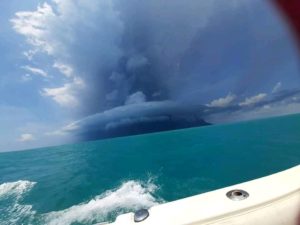
May 18 , 2022.
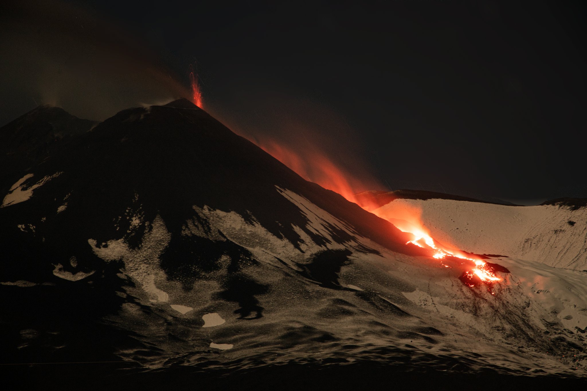
Italy / Sicily , Etna :
Communique on the activity of Etna, May 17, 2022 17:20 (15:20 UTC).
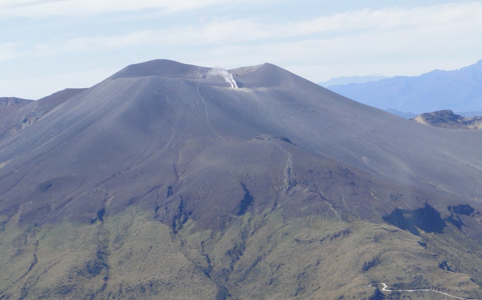
The National Institute of Geophysics and Volcanology, Osservatorio Etneo announces that after the opening of an effusive vent on the northern flank of the Southeast Crater, communicated on 05/12/2022 at 8:38 p.m. local time, placed at an altitude of about 3250 m, the effusive activity stabilized in the following days, producing a lava flow which develops towards the East-North-East in the deserted Valle del Leone whose most advanced front has currently reached an altitude between 2400 and 2300 m.
At the same time, the Southeast Crater is affected by a discontinuous Strombolian explosive activity of variable intensity which, in the most intense phases, produces a modest emission of ash which is rapidly diluted in the atmosphere.
From the seismic point of view, compared to the press release of May 12, the trend towards the gradual increase in the average amplitude of the tremor continues in the range of high values. The sources of the tremor are located in the Southeast Crater around 3000 m above sea level. The infrasound activity is of medium-low level and is mainly located in the Bocca Nuova region and from May 14 , also in the Southeast Crater. The amplitudes are medium-low.
From a ground deformation perspective, the GNSS and tilt monitoring networks have not shown any significant changes over the past few hours.
Further updates will be communicated soon.
Source : INGV.
Photo : Guide Alpine Vulcanologiche Etna
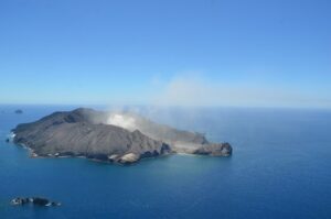
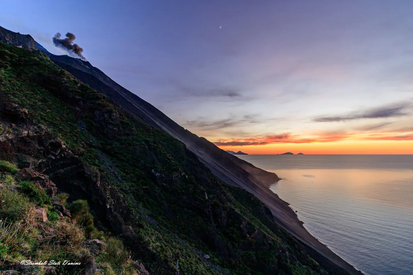
Italy , Stromboli :
WEEKLY BULLETIN, from May 09, 2022 to May 15, 2022. (issue date May 17, 2022)
ACTIVITY STATUS SUMMARY
In the light of the surveillance data, it is highlighted:
1) VOLCANOLOGICAL REMARKS:
During this period, normal Strombolian-type explosive activity was observed, interrupted by a major explosive sequence on May 13. The total hourly frequency of explosions was medium-low (6-10 events/h) until May 13, the following days the frequency was low (2-3 events/h). The intensity of the explosions was low and medium in the area of the North crater and low in the area of the Center-South crater.
2) SEISMOLOGY: The seismological parameters monitored do not show any significant changes, except for the sequence of explosions of greater amplitude than the ordinary activity recorded on 05/13.
3) GROUND DEFORMATIONS: Over the period under review, the island’s ground deformation monitoring networks detected temporary variations during the explosive sequence of May 13 (2:42 p.m.-2:43 p.m. UTC), particularly on inclinometer signals.
4) GEOCHEMISTRY: SO2 flux at a medium-low level,
CO2 flux on the crater floor (Pizzo) in average values,
C/S ratio in the plume at very high values.
Isotope ratio of Helium dissolved in the thermal water table at high values (sample of April 26, 2022).
5) SATELLITE OBSERVATIONS: The thermal activity observed by satellite was at a low level.
VOLCANOLOGICAL OBSERVATIONS
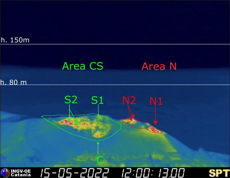
During the observation period, the eruptive activity of Stromboli was characterized through the analysis of images recorded by the INGV-OE surveillance cameras (altitude 190m, Punta Corvi, altitude 400m and Pizzo). The explosive activity was mainly produced by 3 (three) eruptive vents located in the North crater area and 2 (two) eruptive vents located in the Center-South crater area. All the mouths are located inside the depression which occupies the terrace of the crater.
On May 13 at 14:43 UTC, a major explosive event was recorded in the Center-South crater area.
Observations of explosive activity captured by surveillance cameras:
Sector N1 located in the North crater area produced explosions mainly of low intensity (less than 80 m high) and medium (less than 150 m high) emitting coarse materials (lapilli and bombs) mixed with fine materials (ashes) until May 13. After the major event, the explosions were of low intensity and pressurized gas jets. Sector N2 showed low intensity explosive activity (less than 80 m in height) emitting coarse materials. The average frequency of explosions varied between 2 and 4 events/h.
In the Center-South zone, sectors C and S1 did not show significant explosive activity except for the major sequence of May 13. Sector S2, with two emission points, showed explosions mainly of low intensity (less than 80 m in height) and medium (less than 150 m) emitting coarse materials mixed with fine materials, until May 13 . After the major event, explosive activity ceased for the remainder of the observation period. The frequency of the explosions varied between zero and 5 events/h.
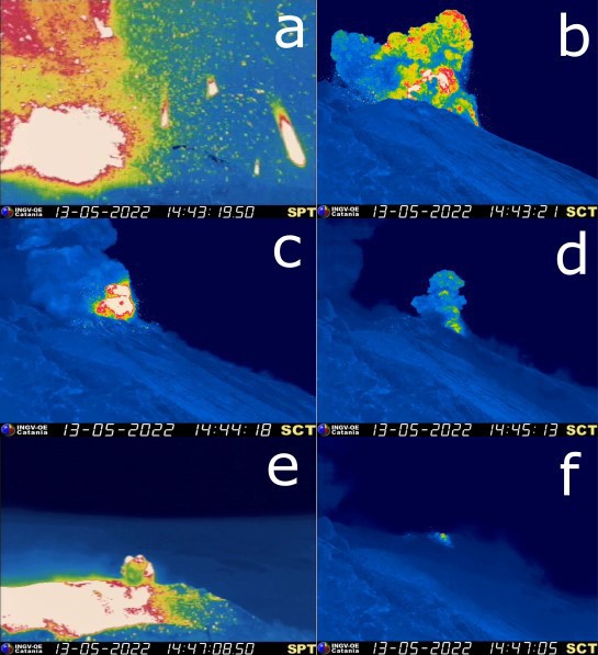
Significant images of the major event of May 13, 2022. a) b) Images of the first explosion from the infrared cameras at Pizzo (SPT) and at altitude 190 (SCT). c) d) Images of two explosions at altitude 190 (SCT). e) f) Images of the last explosions from the Pizzo (SPT) and 190 altitude (SCT) cameras.
Description of the major event of May 13.
On May 13 at 2:43:12 p.m. (all times UTC), a major explosive sequence was produced in the South-Central crater area. 6 main explosions have been identified, below is the chronological description of the explosive sequence:
(i) at 14:43:12 the first, most energetic pulse originates from the South vent of sector S2 and rapidly involves sector S1. The duration of this impulse is about 8 s, the products exceeded 300 m in height and fell abundantly in the East and South-East direction, also falling on the Pizzo. (Fig.3.3 a-b)
(ii) At 14:43:22 a second explosion emerges from sector S1 of less intensity than the first, lasting about 10 s.
(iii) At 14:43:45 a third explosion emerges from sector S2 for about 10 sec
(iv) 14:44:15 – 14:44:57 two explosions lasting 6 and 20 seconds respectively, probably located in sector S1 (fig.3.3 c-d)
(v) At 14:47:03 the explosion that puts an end to the major event is produced by sector S1 for about 15 s. (Fig.3.3e-f)
The major event lasted in total about 4 minutes and after the first two pulses emitting mainly coarse material, the following pulses showed an enrichment in fine component (ash). It was not possible to assess the contribution of sector C to the event due to the abundant relapse of the products, except for the first impulse which was characterized by a modest explosion.
Campaign observations following the May 13, 2022 event.
On May 14, an inspection was carried out in the summit zone within the framework of the activities of the DPC/INGV Annex A convention, in order to carry out the survey of the fallout deposit and to sample the products emitted and to define the morpho-structural changes of the crater terrace following the May 13 event. The lowest altitude where the products were observed was at 450 m above sea level, in the reeds. The presence of impact craters in the trajectory suggests that the products impacting the ground rolled downwards. In fact, the first clear impacts of primary fall, of exclusively lithic material, were found along the bends that go up the Liscione at an altitude of between 700 and 830 m approximately. (Fig. 3.4a-b). Bombs of a lithic nature, whose size varies from decimetric to metric, were observed near the base at an altitude of 850 m (Fig. 3.4 c-d).

Fig. 3.4 Areas affected by product fallout on May 13: a) 830 m above sea level. b) 700 m above sea level, the red circle highlights an impact crater. c) d) lithics close to the ground at an altitude of 850 m. e) the crater terrace taken from Pizzo.
Going up towards the Pizzo, there are no obvious impacts, present rather in small numbers and of decimetric size near the SPT video station, hit in full by a stone, but still fully functional. The first slags of very light and elongated juvenile material are found in the Pizzo area. The cover is sporadic and the size of these slags is from centimeter to decimeter.
Going down towards the « fortins » area on the southern slope (no more than 890 m above sea level), there are slags of juvenile material of dimensions and characteristics comparable to those found on the Pizzo.
Observation from above of the Fossetta area did not identify any obvious impacts.
Regarding the morphological changes of the crater terrace (Fig. 3.4 e), these were evident from the previous inspection carried out on May 10, and only affected the Center-South zone. The sequence of vents in the CS crater area is deeper and elongated in the direction of the most central part. A lenticular deposit is present on the southeast edge of the Center-South depression.
During the observation period, around 10-11 hours, no explosion occurred, only two gas emissions towards the N1 sector and towards the Center South zone.
Source : INGV.
Photos : INGV , Stromboli stati d’animo.
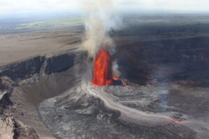
Colombia , Purace :
Weekly bulletin of the activity of the Puracé volcano – Los Coconucos volcanic chain
The activity level of the volcano continues at the Yellow activity level or (III): changes in the behavior of volcanic activity.
From the analysis and evaluation of the information obtained through the monitoring network of the Puracé volcano – Los Coconucos volcanic chain, during the week of May 10 to 16, 2022, the COLOMBIAN GEOLOGICAL SERVICE – Volcanological and Seismological Observatory of Popayan reports that:
Regarding the number and released energy of recorded seismic events, a stable behavior was observed, compared to previous weeks. For the period evaluated, 693 seismic events were recorded, of which 75 were associated with rock fracturing processes (type VT) and 618 with fluid dynamics in volcanic conduits; of these, 462 were classified as long duration type events (LP type), two (2) hybrid form events (HB type), 26 low frequency events (BF type), one (1) « Tornillo » ( type TO), 87 in the form of low-energy tremor pulses (type TR). Finally, the low-energy continuous tremor recording stands out, sustained for nearly 10 hours on May 14.
• The geodetic network of GNSS (Global Navigation Satellite System) stations monitoring ground deformation continues to record a process associated with inflation.
• With regard to the monitoring of volcanic gases, the sulfur dioxide (SO2) emission fluxes recorded by the telemetry and field stations showed a stable behavior compared to the previous week, reaching a maximum flow emitted at permanent stations of 523 t/day. The other gas analysis instruments in the volcanic influence zone do not show any relevant changes for the evaluated period.
• In the monitoring of surface activity, the images obtained during the week thanks to the Mina, Lavas Rojas and Cerro Sombrero web cameras showed degassing of the volcanic system, with a white column oriented preferentially towards the North-West.
• On May 11, a drone flyby was carried out over the Curiquinga volcano, where it was possible to observe the previously reported cracks inside this volcano. On average, the cracks reach 45 m in length, 6 m in depth and between 10 and 20 m in width. Moreover, no degassing of these cracks was noted.
• Sensors monitoring magnetic and electric fields and infrasonic waves did not record variations associated with changes in volcanic activity.
Therefore, it is concluded that significant variations in volcanic activity continue to be recorded, in accordance with the behavior expected at activity level III (yellow level), which could evolve towards states of greater activity.
Source et photos : SGC
Guatemala , Santiaguito :
SPECIAL VOLCANOLOGICAL BULLETIN
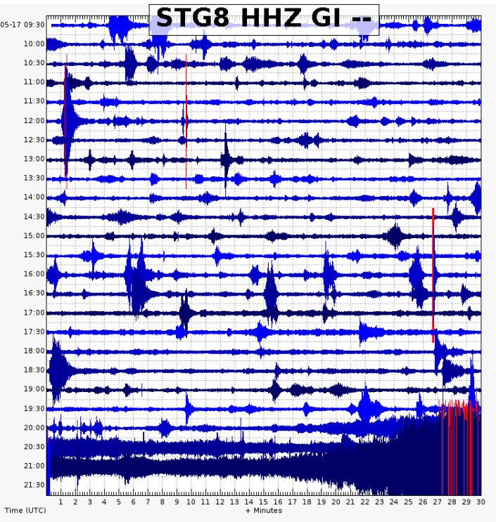
Precipitation on the Santa María-Santiaguito volcanic complex is currently generating the descent of lahars in the course of the San Isidro River, a tributary of the Tambor River to the south-southwest of the volcano. This lahar can carry a pasty mixture of water which can be at a high temperature due to the high activity that the volcano has had on this flank, blocks of rock up to 3 meters in diameter and finer sediments, as well only logs and tree branches. The lahar on its way produces vibrations in the ground which are recorded in the seismic stations close to the bed of the river, in this case the STG8.
If these rainy conditions persist in the region, the possibility of lahars descending into one of the other ravines of this volcano is not excluded.
INSIVUMEH maintains visual and instrumental monitoring of volcanic activity through its field observers, seismic stations and web cameras.
Source : Insivumeh.
Indonesia , Semeru :
VOLCANO OBSERVATORY NOTICE FOR AVIATION – VONA
Issued : May 16 ,2022
Volcano : Semeru (263300)
Current Aviation Colour Code : ORANGE
Previous Aviation Colour Code : orange
Source : Semeru Volcano Observatory
Notice Number : 2022SMR137
Volcano Location : S 08 deg 06 min 29 sec E 112 deg 55 min 12 sec
Area : East java, Indonesia
Summit Elevation : 11763 FT (3676 M)
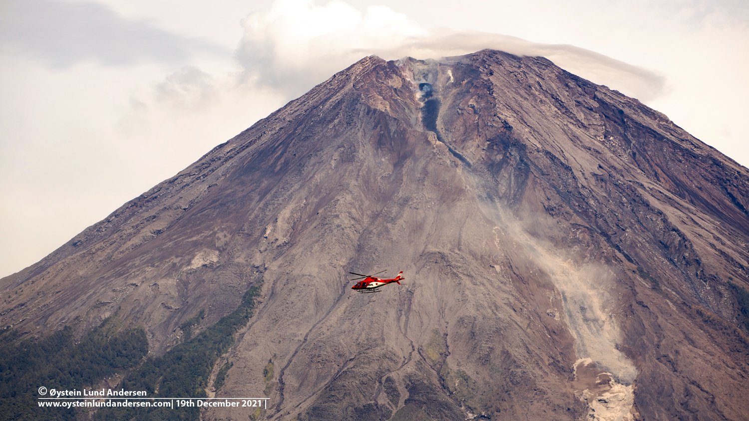
Volcanic Activity Summary :
Eruption with volcanic ash cloud at 23h34 UTC (06h34 local).
Volcanic Cloud Height :
Best estimate of ash-cloud top is around 12723 FT (3976 M) above sea level, may be higher than what can be observed clearly. Source of height data: ground observer.
Other Volcanic Cloud Information :
Ash-cloud moving to southwest
Source : Magma Indonésie .
Photo : Oystein Lund Andersen.