February 23, 2020. EN. Kamchatka : Klyuchevskoy , El Salvador : San Miguel (Chaparrastique) , Iceland : Thornbjorn / Reykjanes , Costa Rica : Turrialba / Poas / Rincon de la Vieja / Irazu / Barva .

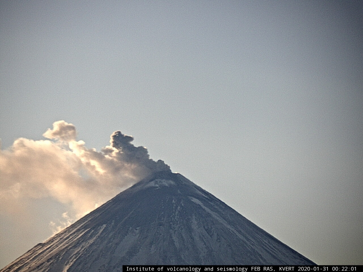
February 23 , 2020.  


Kamchatka , Klyuchevskoy : 

VOLCANO OBSERVATORY NOTICE FOR AVIATION (VONA).

Issued: February 23 , 2020 
Volcano: Klyuchevskoy (CAVW #300260)
Current aviation colour code: ORANGE
Previous aviation colour code:orange
Source: KVERT
Notice Number: 2020-25
Volcano Location: N 56 deg 3 min E 160 deg 38 min
Area: Kamchatka, Russia
Summit Elevation: 15580 ft (4750 m)

The explosive eruption of Klyuchevskoy volcano continues: the Vulcanian activity is observing on 30-31 January, 2020.


Volcanic Activity Summary:
A moderate explosive eruption of the volcano continues, the Strombolian activity is noting. According to satellite data, a gas-steam plume containing some amount of ash is extending for 84 km to the east of the volcano.
A moderate explosive eruption of the volcano continues. Ash explosions up to 16,400-23,000 ft (5-7 km) a.s.l. could occur at any time. Ongoing activity could affect low-flying aircraft.

Volcanic cloud height:
16400-18040 ft (5000-5500 m) AMSL Time and method of ash plume/cloud height determination: 20200223/0540Z – Himawari-8

Other volcanic cloud information:
Distance of ash plume/cloud of the volcano: 52 mi (84 km)
Direction of drift of ash plume/cloud of the volcano: E / azimuth 89 deg

Source : Kvert .

Photo : IVS FEB RAS, KVERT.


El Salvador , San Miguel ( Chaparrastique ) :

At 10:55 a.m. The San Miguel volcano emitted an ash cloud over a period of 10 minutes. The cloud reached a maximum of 400 meters above the level of the crater and the generation of at least two pulses was observed, which manifested itself in the form of a small column of ash and gas (see figure 1).

Volcanologists in the Piedra Azul region, 5 km southwest of the crater, report a slight fall of ash in the region. During this period, the seismic amplitude recorded in the VSM station located in the upper part of the northern flank of the volcano, reached 510 units in ten minutes on average, 150 units being normal. The recording of the earthquakes shows that they were generated continuously, which is known as a volcanic tremor (see Figure 2). After this event, until the publication of this report, the volcano maintained a slight degassing of its crater.
The scenario observed today was considered most likely in special report 1, released yesterday. According to the evaluation of volcanic activity, this scenario could continue in the coming days, without excluding a process of greater energy, which could generate higher columns and containing more ash. What happened today, at 10:55 a.m., technically, is considered a small-scale eruptive process.

Figure 2. Seismogram recorded today in the VSM station

The Ministry of the Environment and Natural Resources (MARN) maintains 7/24 surveillance of the volcano and close communication with the Directorate General of Civil Protection and local observers.
We call on residents, tourists and mountaineers to stay away from the crater of the volcano, due to small explosions with ash fumes that the volcano presents, which can lead to the release of gas and ash in a southern direction -West, transported by preferential winds.
This report will be updated next Friday, February 28. In the event of a significant change in the activity of the volcano, a special prior report will be issued.

Source : Marn .


Iceland  , Thornbjorn / Reykjanes :

This evening, Feb. 22nd at 20:10 an M3.1 earthquake was detected 3.6 km N of Reykjanestá. A few aftershocks have been detected. A seismic swarm has been ongoing there since 15th of February.
The IMO warns about cave excursions in the Eldvörp area on the Reykjanes Peninsula. Hazardous levels of CO2 and O2 were measured there on Thursday, 20th of February, in a cave close to a parking lot, popular for hikers.

The earthquake swarm on Reykjanes peninsula is ongoing.

The row of craters at Reykjanes Peninsula called Eldvörp was formed in an eruption in the early 13th century . A lava field from the eruption covers a large area west of the small mountains Svartsengi and Þorbjörn. The lava field stretches from the northernmost crater all the way to the south shore. The row of craters is about 10 kilometers long and consists of many craters, and some are even still warm with steam evaporating from the ground, indicating that the craters are still active and the magma still lurking beneath.

Sources : IMO , hiticeland.com .

Photo : Ómar Ragnarsson.


Costa Rica , Turrialba / Poas / Rincon de la Vieja / Irazu / Barva :

Daily report on the state of volcanoes. , Date: February 21, 2020, Updated at: 11:45:00 AM.

Turrialba volcano:

No eruption is reported.
Seismic activity is similar to that of yesterday.
At the time of this report, the winds were blowing southwest.
Seismographs continue to record mainly long-period (LP) earthquakes. The seismic signal of volcanic tremors is not recorded. There was no eruption or emission of ash. The fumaroles of the West crater are rich in water vapor.

Poas Volcano:


No eruption is reported.
Seismic activity is more important than that of yesterday.
At the time of this report, the winds were blowing southwest.
Seismographs record LP earthquakes of the long period (LP) type with very short amplitude and intermittent volcanic tremors. The acid lake persists in the active crater with submerged fumaroles and also partially out of the water.

Rincon de la Vieja volcano


No eruption is reported.
Seismic activity is more important than that of yesterday.
At the time of this report, the winds were blowing northwest.
Seismographs record seismic signals of intermittent volcanic tremors and sporadic long-period (LP) earthquakes. There are no hydrothermal explosions or significant emission of vapor and gas from the active crater. The recent rains continue to gradually carry away some of the materials that have accumulated in the high beds of rivers north of Rincon due to the hydrothermal explosion of January 30, 2020.

Irazú volcano


No eruption is reported.
A seismic swarm has occurred but is associated with tectonic and non-volcanic activity. There was a small shift in the antenna sector on February 16. The main slide in the tower sector continues with constant acceleration. The level of the lake is rapidly decreasing.

Barva volcano:


No eruption is reported.
Sporadic volcano-tectonic (VT) earthquakes in the vicinity have been recorded.

Source : Ovsicori / Maria Martinez Cruz.

Photos : Dr Paulo Ruiz , RSN , Federico Chavarria Kopper


23 Février 2020. FR. Kamchatka : Klyuchevskoy , El Salvador : San Miguel ( Chaparrastique ) , Islande : Thornbjorn / Reykjanes , Costa Rica : Turrialba / Poas / Rincon de la Vieja / Irazu / Barva .

23 Février 2020.  


Kamchatka , Klyuchevskoy : 

AVIS D’OBSERVATION DU VOLCAN POUR L’AVIATION (VONA).

Émis: 23 Février 2020 
Volcan: Klyuchevskoy (CAVW # 300260)
Code couleur actuel de l’aviation: ORANGE
Code couleur de l’aviation précédent: orange
Source: KVERT
Numéro de l’avis: 2020-25
Emplacement du volcan: N 56 deg 3 min E 160 deg 38 min
Région: Kamchatka, Russie
Altitude du sommet: 15580 pi (4750 m).

L’éruption explosive du volcan Klyuchevskoy se poursuit: l’activité vulcanienne est observée du 30 au 31 janvier 2020.


Résumé de l’activité volcanique:
Une éruption explosive modérée du volcan se poursuit, on constate une activité strombolienne. Selon les données satellitaires, un panache gaz-vapeur contenant une certaine quantité de cendres s’étend sur 84 km à l’Est du volcan.
Cette éruption se poursuit. Des explosions de cendres jusqu’à 16 400-23 000 pi (5-7 km) d’altitude pourraient survenir à tout moment. L’activité en cours pourrait affecter les aéronefs volant à basse altitude.

Hauteur des nuages ​​volcaniques:
16400-18040 pi (5000-5500 m) AMSL Heure et méthode de détermination du panache de cendres / hauteur des nuages: 20200223 / 0540Z – Himawari-8

Autres informations sur les nuages ​​volcaniques:
Distance du panache de cendres / nuage du volcan: 84 km
Direction de la dérive du panache de cendres / nuage du volcan: E / azimut 89 deg.

Source : Kvert .

Photo : IVS FEB RAS, KVERT.


El Salvador , San Miguel ( Chaparrastique ) :

À 10 h 55 Le volcan San Miguel a émis un nuage de cendres sur une période de 10 minutes. Le nuage a atteint un maximum de 400 mètres au-dessus du niveau du cratère et la génération d’au moins deux impulsions a été observée, qui s’est manifestée sous la forme d’une petite colonne de cendres et de gaz (voir figure 1).

Les volcanologues qui se trouvent dans la région de Piedra Azul, située à 5 km au Sud-Ouest du cratère, signalent une faible chute de cendres dans la région. Au cours de cette période, l’amplitude sismique enregistrée dans la station VSM située dans la partie supérieure du flanc Nord du volcan, a atteint 510 unités en dix minutes en moyenne, 150 unités étant normales. L’enregistrement des tremblements de terre montre qu’ils ont été générés en continu, ce qui est connu comme un tremor volcanique (voir figure 2). Après cet événement, jusqu’au moment de la publication de ce rapport, le volcan a maintenu un léger dégazage de son cratère.
Le scénario observé ce jour était considéré comme le plus probable dans le rapport spécial 1, publié hier. Selon l’évaluation de l’activité volcanique, ce scénario pourrait se poursuivre au cours des prochains jours, sans exclure un processus de plus grande énergie, qui pourrait générer des colonnes plus élevées et contenant plus de cendres. Ce qui est arrivé aujourd’hui, à 10 h 55, techniquement, est considéré comme un processus éruptif de faible ampleur.

Figure 2. Sismogramme enregistré ce jour dans la station VSM

Le ministère de l’Environnement et des Ressources naturelles (MARN), maintient une surveillance 7/24 du volcan et une communication étroite avec la Direction générale de la protection civile et les observateurs locaux.
Nous appelons les résidents, les touristes et les alpinistes à rester à l’écart du cratère du volcan, en raison de petites explosions avec des émanations de cendres que le volcan présente, pouvant aboutir à la sortie de gaz et de cendres dans une direction Sud-Ouest, transportés par des vents préférentiels .
Ce rapport sera mis à jour vendredi prochain, le 28 février. En cas de changement significatif dans l’activité du volcan, un rapport spécial préalable sera émis.

Source : Marn .


Islande , Thornbjorn / Reykjanes :

Hier soir, 22 février à 20h10, un tremblement de terre de M3.1 a été détecté à 3,6 km au nord de Reykjanestá. Quelques répliques ont été détectées. Un essaim sismique y est en cours depuis le 15 février.
L’OMI met en garde contre les excursions dans les grottes dans la région d’Eldvörp sur la péninsule de Reykjanes. Des niveaux dangereux de CO2 et d’O2 y ont été mesurés le jeudi 20 février, dans une grotte près d’un parking, populaire pour les randonneurs.

L’essaim de tremblements de terre sur la péninsule de Reykjanes est en cours.

La rangée de cratères de la péninsule de Reykjanes appelée Eldvörp s’est formée lors d’une éruption au début du XIIIe siècle. Le champ de lave de l’éruption couvre une grande zone à l’Ouest des petites montagnes Svartsengi et Þorbjörn. Le champ de lave s’étend du cratère le plus septentrional jusqu’à la rive Sud. La rangée de cratères mesure environ 10 kilomètres de long , certains sont même encore chauds avec de la vapeur s’évaporant du sol, indiquant que les cratères sont toujours actifs et que le magma se cache encore en dessous.

Sources : IMO , hiticeland.com .

Photo : Ómar Ragnarsson.


Costa Rica , Turrialba / Poas / Rincon de la Vieja / Irazu / Barva :

Rapport quotidien de l’état des volcans. , Date: 21 Février 2020 , Mise à jour à: 11:45:00.

Volcan Turrialba:


Aucune éruption n’est signalée.
L’activité sismique est similaire à celle d’hier.
Au moment de ce rapport, les vents soufflaient vers le Sud-Ouest.
Les sismographes continuent d’enregistrer principalement des tremblements de terre de type longue période (LP) . Le signal sismique de tremors volcaniques n’est pas enregistré. Il n’y a eu ni éruption ni émission de cendres. Les fumerolles du cratère Ouest sont riches en vapeur d’eau.

Volcan Poas :


Aucune éruption n’est signalée.
L’activité sismique est plus importante que celle d’hier.
Au moment de ce rapport, les vents soufflaient vers le Sud-Ouest.
Les sismographes enregistrent des séismes LP de type longue période (LP) d’amplitude très courte et des tremors volcaniques par intermittence. Le lac acide persiste dans le cratère actif avec des fumerolles immergées et également partiellement hors de l’eau.

Volcan Rincon de la Vieja


Aucune éruption n’est signalée.
L’activité sismique est plus importante que celle d’hier.
Au moment de ce rapport, les vents soufflaient vers le Nord-Ouest.
Les sismographes enregistrent des signaux sismiques de tremors volcaniques par intermittence et des tremblements de terre sporadiques de type longue période (LP). Il n’y a pas d’explosions hydrothermales ou d’émission significative de vapeur et de gaz depuis le cratère actif. Les pluies récentes continuent d’entraîner progressivement une partie des matériaux qui se sont accumulés dans les hauts lits des rivières au Nord du Rincon en raison de l’explosion hydrothermale du 30 janvier 2020.

Volcan Irazú


Aucune éruption n’est signalée.
Un essaim sismique s’est produit mais est associé à une activité tectonique et non volcanique. Il y a eu un petit glissement dans le secteur des antennes le 16 février. Le glissement principal dans le secteur des tours se poursuit avec une accélération constante. Le niveau du lac diminue rapidement.

Volcan Barva:

Aucune éruption n’est signalée.
Des tremblements de terre sporadiques de type volcano-tectoniques ( VT) à proximité ont été enregistrées.

Source : Ovsicori / Maria Martinez Cruz.

Photos : Dr Paulo Ruiz , RSN , Federico Chavarria Kopper