August 28 , 2019.
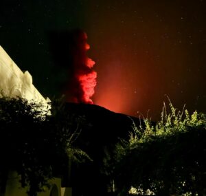
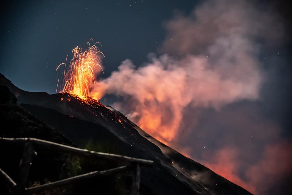
Italy , Stromboli :
Stromboli Weekly bulletin , 08/19/2019 – 25/08/2019 (date of publication of 27/08/2019)
1. SUMMARY OF ACTIVITY
According to the surveillance data, we highlight:
1) VOLCANOLOGICAL OBSERVATIONS: During this period, an explosive activity of Strombolian type was observed, accompanied by degassing, splashing and lava spilling activities. The hourly frequency of the explosions fluctuated between medium-high values (18 events / h on August 20) and very high values (26 events / h on August 22 and 23). The intensity of the explosions was mainly medium to low in the North and Middle-Upper Crater Zone in the Center-South Crater Zone.
2) SISMOLOGY: The seismological parameters do not show any significant changes.
3) DEFORMATIONS: There is no significant change regarding the permanent GPS and Tilt networks.
4) GEOCHEMISTRY: the flow of SO2 indicates degassing at a medium level. The recorded values of the C / S ratio of the restored station are at medium to high levels. The 3He / 4He isotopic ratio is stable at medium-low levels.
VOLCANOLOGICAL OBSERVATIONS.
During the period under review, Stromboli eruptive activity was characterized by the analysis of thermal and visible images recorded by the cameras located at 400 meters, at Punta dei Corvi and at an altitude of 190 meters. Morpho-structural and volcanological observations were also made by the INGV-OE staff during the 25 August field investigations and the 23 August fly-by with the helicopter provided by the 2nd Air Unit of the coastguard of Catania.
Observations confirmed that Strombolian activity was continuing in a sustainable manner both in the North-Central Zone and in the South-Central Zone. In particular, in the North zone, the vents located in the northern part mainly had an explosive activity of medium to low intensity (less than 120 m high) emitting coarse materials (lapilli and bombs), while the vents some of which are placed on the rim of the crater facing the Sciara del Fuoco showed intense and continuous projection activity sometimes interrupted by low intensity explosions and emissions of coarse materials.
The frequency of explosions in the North zone ranged between 7 and 15 events / h.
In zone CS, intense explosions emitting fine materials (ash) were observed with coarse mixed materials, exceeding 250 m above the crater terrace, from the mouths placed in the main slag cone; while from the mouth in the central area, low intensity explosions of coarse material were observed, sometimes mixed with fine material. The frequency of explosions in the CS zone ranged between 9 and 16 events / h.
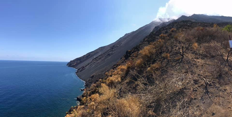
On day 23 August, during the overflight, it was observed that the area of the North crater has a morpho-structural structure characterized by at least 13 mouths aligned in the Northwest direction and located along the edge of the crater overlooking the Sciara del Fuoco. While the Center-South zone of the crater presents a large cone of slag with two mouths inside, a collapsing crater and two small cones of slag. In particular, from the base of cone 5, a short lava tunnel develops inside the terrace of the crater, which changes slope with the Sciara del Fuoco and feeds two ephemeral mouths, which generate two small flows of lava, of length about 50 m maximum, whose fronts are located about 700 m of altitude. As for the effusive activity produced by the two ephemeral mouths located in the South Central zone of the crater terrace, it was characterized by the presence of modest lava flows that until August 20 were located in the upper part of the Sciara del Fuoco producing accumulation of blocks along the coast. As of August 21, the lava emissions from the ephemeral vents, which produced only small lava flows that remained confined immediately below the Central-South crater zone, have significantly decreased, as evidenced by the overflight of August 23rd.
During the past week, 11 seismic signals were recorded that could be associated with small-scale landslides, visible from STRE, STRA and STRG stations.
The amplitude of volcanic tremor showed values generally between medium-low and medium-high, with some peaks at medium-high values.
The occurrence frequency of VLP earthquakes had values between 18 and 24 events / hour.
The magnitude of VLP-like events was generally low, with some medium-low events, showing a slight increase on 21/08 with values between low and medium-low.
The amplitude of the explosion earthquakes was generally low, with some medium-low events, showing a slight increase on 22/08 with some medium-low events.
Please note the presence of some hybrid low energy events .
…/…
Source : INGV Vulcani.
Read the full article : file:///C:/Users/Utilisateur/AppData/Local/Packages/Microsoft.MicrosoftEdge_8wekyb3d8bbwe/TempState/Downloads/BollettinoStromboli20190827%20(1).pdf
Photos : Marco Iacono , LGS – Laboratorio Geofisica Sperimentale.
Colombia , Galeras :
Weekly bulletin of the Galeras volcano.
The level of activity of the volcano continues at: YELLOW LEVEL ■ (III): CHANGES IN THE BEHAVIOR OF THE VOLCANIC ACTIVITY.
Following the activity of VOLCÁN GALERAS, the COLOMBIAN GEOLOGICAL SERVICE (SGC) reports that:
During the period from August 20 to August 26, 2019, the seismic occurrences were weak, similar to those of the last weeks and characterized mainly by the recording of seismicity associated with the fracture of the rock (VT type earthquakes). The energy released by this seismicity has increased mainly due to the occurrence of two earthquakes of magnitude 2.3 and 2.7, recorded on August 21 at 17:35. and 19:20 respectively, which have been reported as having been felt in the city of Pasto. The first was located about 6.0 km east-northeast of the Galeras volcano and the second about 5.0 km south-southeast of the volcano.

On August 21st, 22nd, 25th and 26th, favorable weather conditions allowed white gas emissions, low pressures and a variable dispersion direction to be observed by the action of winds from different sectors of the active cone.
The other geophysical and geochemical monitoring parameters of the Galeras volcano did not show any significant variations.
The COLOMBIAN GEOLOGICAL SERVICE remains attentive to the evolution of the volcanic phenomenon and will continue to report the changes observed as soon as possible.
Source : SGC.
Photo : capra
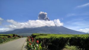
Indonesia , Karangetang :
Level of activity at Level III (SIAGA). G. Karangetang (1,784 m above sea level) has been re-erupted since November 25, 2018.
Since yesterday and until this morning, the volcano was clearly visible until it was covered by fog. The smoke from the crater is observed at a maximum height of 150 meters above the summit, medium pressure, white color and moderate intensity.
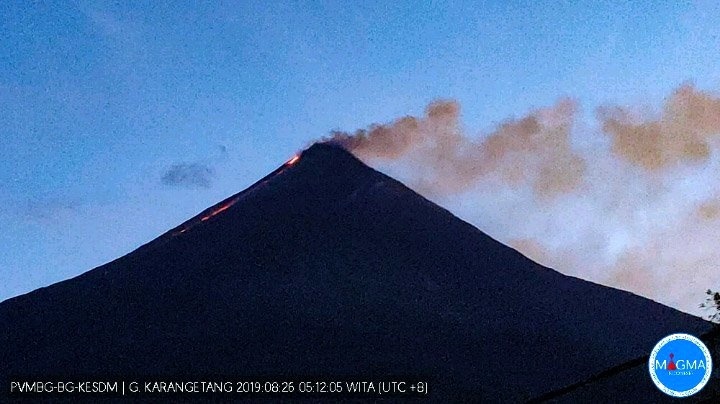
Emission of brown ash and lava flows on 26.08.2019 / 05h12 – Webcam PVMBG
The seismographic recording of August 27, 2019, noted:
19 avalanche earthquakes
23 earthquakes of explosion
3 hybrid earthquakes
3 distant tectonic earthquakes
1 harmonic tremor
Tremor continuous amplitude 0.25 – 3 mm, dominant 1 mm.
Recommendation:
As of August 27, 2019, the technical recommendations were as follows:
The public and visitors / tourists are advised not to travel within 2.5 km of the main crater (South) and crater II (North), as well as in the sectoral expansion zone of Crater II. northwest 4 km and from the main crater west up to 3 km.
Communities around the rivers that rise at the top of Mount Karangetang need to be better prepared for the potential threat of lahars and sudden floods that can spread to the coast.
VONA:
The latest VONA code was YELLOW, published November 25, 2018 at 13:32 WITA, related to the volcanic ash emission from a height of approximately 2,284 meters above sea level or approximately 500 meters above the summit, the wind blowing to the East.
Source : PVMBG
Photo : PVMBG via Bernard Duyck , hshdude .
Mexico , Popocatepetl :
August 27, 11:00 am (August 27, 16:00 GMT).
In the last 24 hours, 99 exhalations have been identified using the monitoring systems of the Popocatepetl volcano, accompanied by water vapor, gas and small amounts of ash. In addition, 521 minutes of tremor and 2 explosions were recorded. A volcano-tectonic earthquake was also recorded at 07:59, with a magnitude estimated at M3.
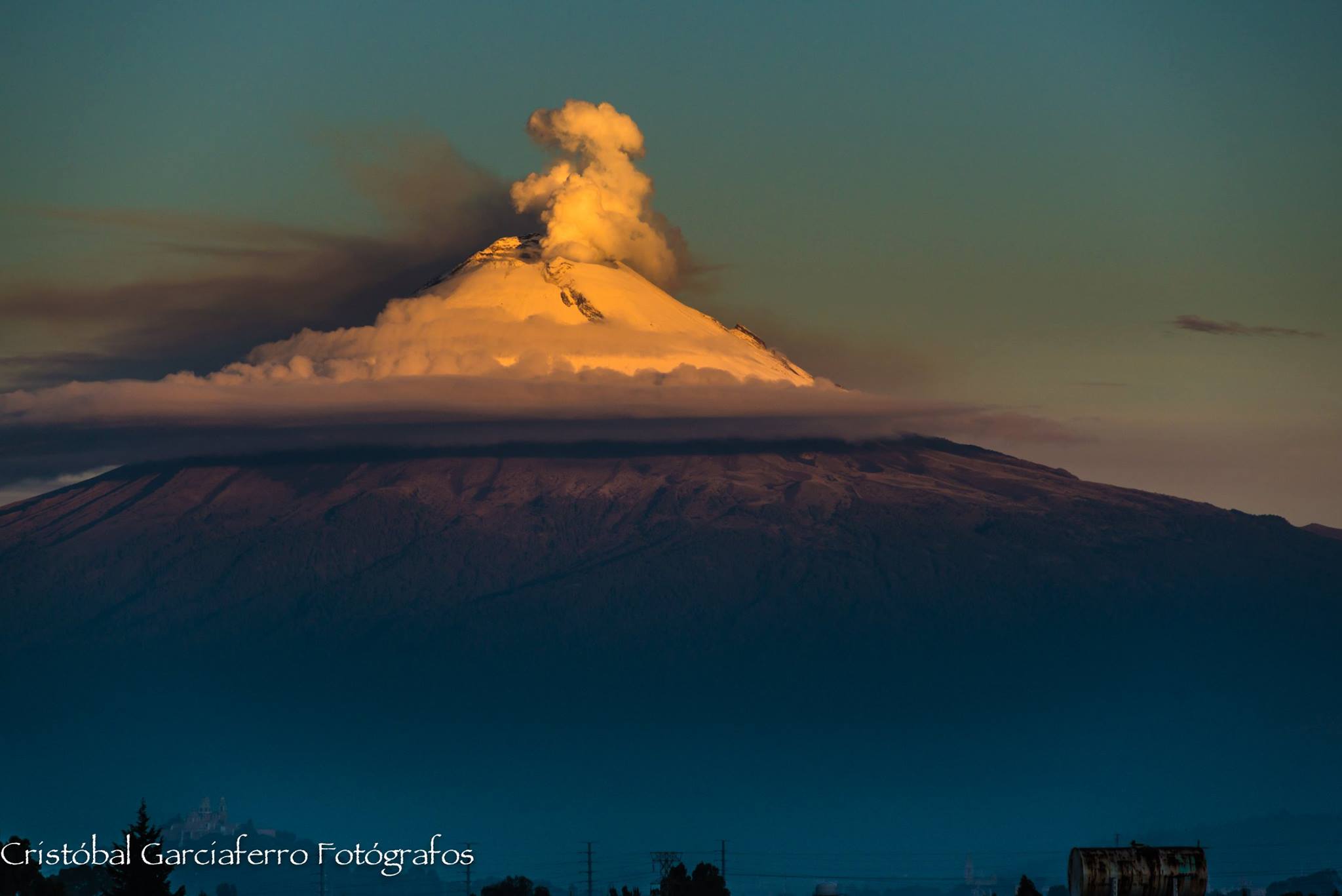
Today and at the time of this report, the volcano has emissions of volcanic gases and ash that are dispersed to the northwest.
CENAPRED urges NOT to approach the volcano and in particular the crater because of the risk of falling ballistic fragments, and in case of heavy rains to stay away from the bottom of the ravines due to the risk of mudslides and debris.
The warning light of Popocatépetl is in YELLOW PHASE 2.
Source : Cenapred .
Photo : Cristobal Garciaferro