August 27 , 2019.
Peru : Ubinas ,
Period of analysis: August 20 to 26, 2019 Arequipa, August 26, 2019.
Alert level: ORANGE
The Geophysical Institute of Peru (IGP) reports that the Ubinas volcano continues its eruptive process. To date, there is seismic activity that is related to the rise of magma; likewise, the recording of bluish gas (magmatic gas) and water vapor emissions observed by surveillance cameras continues. In addition, after the analysis of the satellite images, thermal anomalies were detected which indicate the proximity of the magma to the surface of the crater. According to this scenario, one would expect a future explosive activity.
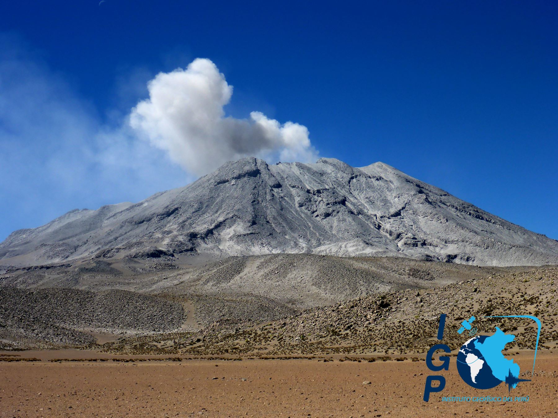
The IGP recorded and analyzed a total of 1,736 seismic events occurring on the Ubinas volcano between August 20 and August 26, 2019, all of a magnitude less than M2.4. During this period of analysis, there was an increase in the number and energy of seismic signals that would be related to the rise of magma (LP and hybrid), with an average of 109 events per day during last week. During this period, no volcanic explosion was recorded.
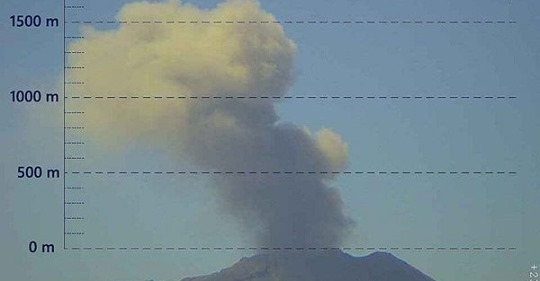
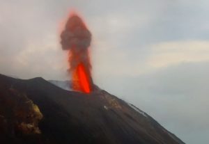
On 26 August, Ubinas volcano surveillance cameras recorded the emission of ash, at a height of less than 2,000 meters above the crater base that dispersed north and northwest of the volcano; moreover, between August 20th and 25th, emissions of blue gas (magmatic gas) and steam were recorded. Satellite monitoring, using information from the MIROVA system, identified the presence of 8 thermal anomalies up to 4 MW, indicating the proximity of the magma to the crater surface. The monitoring of the deformation of the volcanic structure, using GNSS data (processed with fast orbits), presents no anomalies.
Source et photo : IGP Pérou .
Peru , Sabancaya :
Period of analysis: August 19 to 25, 2019, Arequipa, August 26, 2019.
Alert level: ORANGE
The Geophysical Institute of Peru (IGP) reports that the eruptive activity of the Sabancaya volcano has remained at moderate levels; that is, with the recording of continuous explosions and the resulting ash emission. Therefore, for the following days, no significant change is expected.
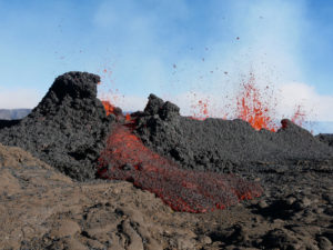
The analysis of records obtained from the seismic network of the Sabancaya volcano for the period from 19 to 25 August 2019 has identified the occurrence of about 2187 earthquakes of volcanic origin, the highest percentage being associated with the movement of magmatic fluids. During this week, an average of 18 low to medium intensity daily explosions were observed.

The monitoring of the deformation of the volcanic structure, using GNSS data (processed with fast orbits), does not present significant anomalies. Visual surveillance, using surveillance cameras, allowed us to identify the presence of columns of gas and ash up to 2.4 km above the top of the volcano, which dispersed to the areas South, Southeast and East of Sabancaya. Satellite monitoring identified 13 volcanic anomalies on the volcano from 3 to 30 MW, associated with the presence of a hot body near the surface and the continued occurrence of explosions.
Source : IGP Pérou .
Photo : Ingemmet.
Indonesia , Anak Krakatau :
Level of activity at level II (Waspada), since March 25, 2019. G. Anak Krakatau (157 m altitude) has experienced an increase in its volcanic activity since June 18, 2018, which was followed by a series of eruptions from September 2018 to February 2019. In August 2019, eruptions still occur but the intensity decreases.
Since yesterday and until this morning, the volcano was covered with fog. The smoke from the crater is not observed.
The seismograph of August 26, 2019, recorded:
3 earthquakes of explosion.
11 low frequency earthquakes
Tremor continuous amplitude 2 – 40 mm, dominant 20 mm
Recommendation:
The public / tourists are not allowed to approach the crater within a radius of 2 km.
VOLCANO OBSERVATORY NOTICE FOR AVIATION – VONA.
Issued: 20190825/1441Z
Volcano: Anak Krakatau (262000)
Current Aviation Colour Code: ORANGE
Previous Aviation Colour Code: orange
Source: Anak Krakatau Volcano Observatory
Notice Number: 2019KRA152
Volcano Location: S 06 deg 06 min 07 sec E 105 deg 25 min 23 sec
Area: Lampung, Indonesia
Summit Elevation: 502 FT (157 M)
Volcanic Activity Summary:
Eruption with ash clouds at 14:32 UTC (21:32 local time). The eruption lasted for 29 seconds.
Volcanic Cloud Height:
Ash-cloud is not visible
Other Volcanic Cloud Information:
Anak Krakatau volcano is not clear.
Remarks:
Eruption recorded on seismogram with maximum amplitude 43 mm and duration 29 second.
Source : PVMBG , Magma Indonésie .
Photo : Martin Hertel ( https://www.facebook.com/photo.php?fbid=2663011190375678&set=gm.2411850948853064&type=3&theater&ifg=1 )
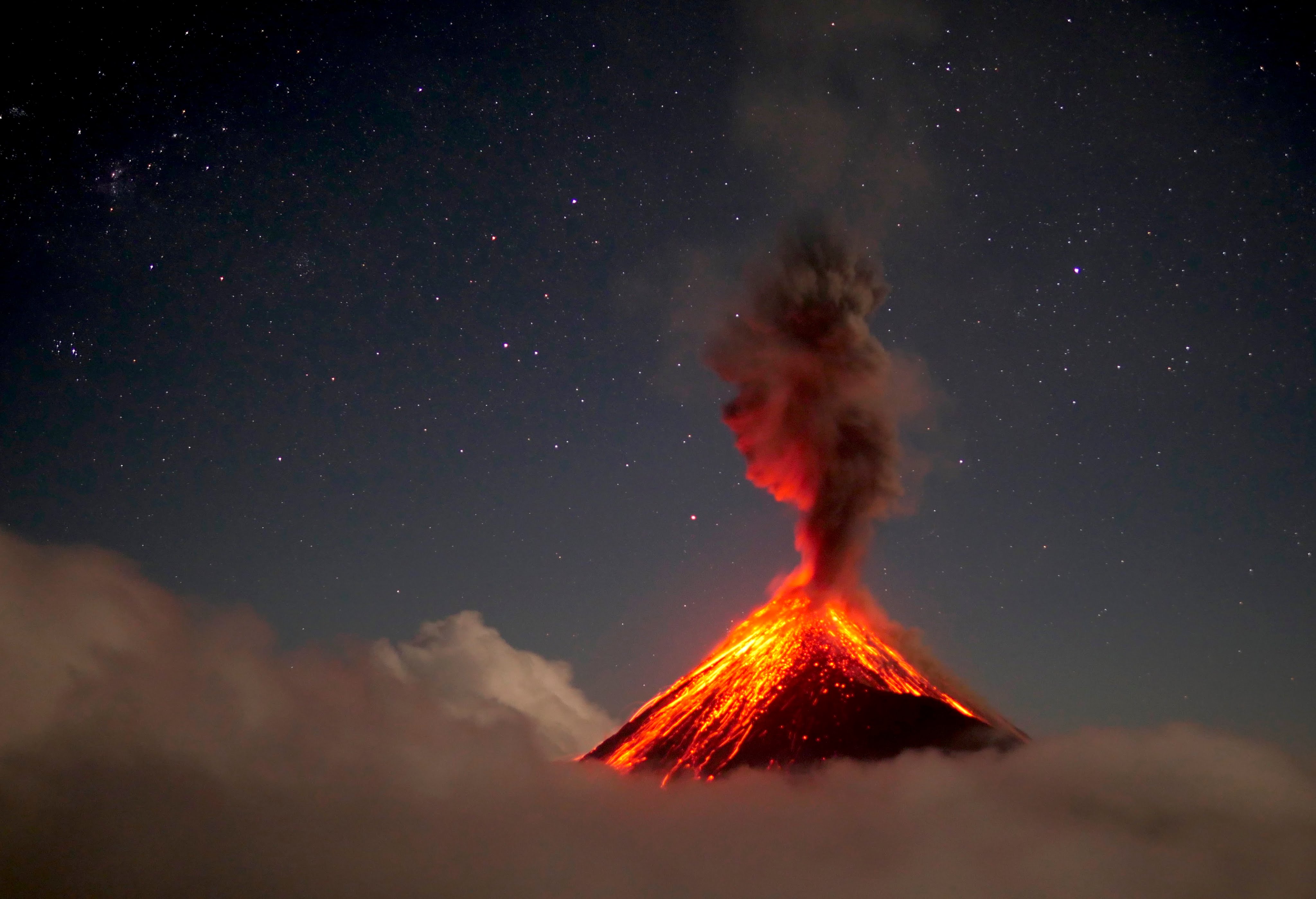
Guatemala , Fuego :
Type of activity: Vulcanian
Morphology: Composite Stratovolcano
Geographical location: 14 ° 28’54˝ North Latitude; 90 ° 52’54˝ West longitude
Height: 3,763msnm.
Atmospheric conditions: Clear
Wind: North West at 8 km / h
Precipitation: 21.1 mm.
Activity:
Presence of white degassing fumarole at an altitude of 4,200 meters above sea level, dispersed to the west and southwest. These generate 14 to 16 weak to moderate explosions per hour, emitting columns of gray ash rising between 4600 and 4700 meters (14435-15420 feet), dispersed over 15 to 20 km to the west and Southwest . At night and in the early morning, incandescent impulses were observed at an altitude of 200 to 350 m with moderate to strong avalanches on the contour of the crater, heading towards the ravines Seca, Taniluya, Ceniza, Trinidad and Las Lajas. Low to moderate rumblings are perceived, causing low to moderate shock waves that vibrate the roofs of homes near the volcano. The noises are similar to those of a train locomotive with 7 minute intervals. Fine particles of ash fall in the areas of Panimaché I, Morelia, Santa Sofia, Porvenir, Palo Verde, Yepocapa and others.
Source : Insivumeh.
Photo :660citynews.com .