August 15 , 2019.
La Réunion , Piton de la Fournaise :
Activity Bulletin from Wednesday, August 14, 2019 at 15:30 (local time).
Alert level: Alert 2-2
The eruption started on August 11, 2019 around 16:20 (local time) continues. Despite rapid fluctuations, the intensity of the eruptive tremor (witnessing the intensity of the eruption) is relatively constant over the last 18 hours (Figure 1).
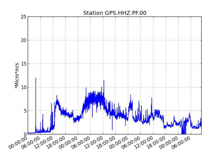
Figure 1: Evolution of RSAM (indicator of volcanic tremor and intensity of eruption) between 04:00 (00:00 UTC) on August 11 and 15:00 (11:00 UTC) on August 14, 2019 on GPS seismic station, the most close to the eruptive site (© OVPF-IPGP).
Since the beginning of the eruption, 44 volcano-tectonic earthquakes have been recorded:
– 31 August 11 from 17h to 24h.
– 7 August 12 from 00h to 24h.
– 6 August 13 from 00h to 24h.
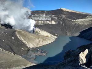
Because of the small inclination of the slopes in the area reached by the flow front on 13/08/2019, its progression is very slow, and the front is still located between 600-650 m altitude (near the Piton Tremblet ), about 2 km from the road (Figure 2)
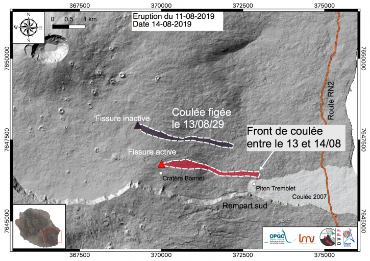
Figure 2: Location of eruptive fissures that opened on 11/08/2019 and the approximate contours of the associated lava flows. (© OVPF-IPGP / OPGC-LMV).
Estimated surface flows from satellite data via HOTVOLC platforms (OPGC – University of Auvergne) and MIROVA (University of Turin) were around 2 m3 / s over the last 24 hours. This flow rate corresponds to a minimum flow, because the bad weather conditions on the volcano since the beginning of the eruption attenuate the satellite signals.
Activity Bulletin from Thursday, August 15, 2019 at 06:30 (local time).
The eruption started on 11/08/2019 at 16:20 local time stopped today, the 15/08/2019 at around 04:20 local time.
The eruptive activity on the surface is currently stopped, only persistent degassing at the level of eruptive fissures and glows at lava flows that are being cooled.
No assumption is discounted as to the evolution of the future situation (final shutdown, resumption of activity on the same site, resumption of activity elsewhere), taking into account the following observables:
– a residual tremor is still recorded on the NTR station, located on the Nez Coupé du Tremblet.
– recording deep earthquakes that indicate that deep magma movements are still present.
Source : OVPF.
Lire l’article : http://www.ipgp.fr/fr/ovpf/bulletin-dactivite-mercredi-14-aout-2019-a-15h30-heure-locale
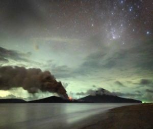
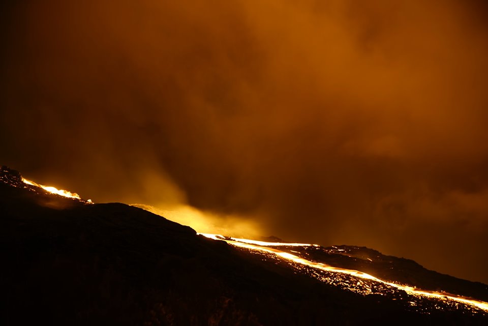
Photo :thanks to Tunnels de lave Réunion : Rando-Volcan
Chile , Copahue :
During this period, 33 seismic events classified as volcano-tectonic (VT) type were recorded, associated with fracturing processes of rigid materials. The event with the greatest energy obtained a local magnitude equal to M 2.2 and was located 15.9 km East-Northeast (ENE) of active crater El Agrio, 2.9 km depth.
Similarly, 9 earthquakes associated with fluid dynamics were recorded under the volcanic building, classified as long period type events (LP), with a maximum reduced displacement value (DRC) of 1.7 cm2. In addition, 101 volcanic tremor events (TR) were recorded, with a maximum displacement value (DRC) of 5.1 cm2.
The continuous tremor signal showed reduced displacement values (DRC) which mainly concentrate between 0.5 and 3.0 cm2, with dominant frequencies between 0.6 and 3.3 Hz mainly.
IP cameras installed near the volcano, weather permitting, made it possible to observe a column of white degassing, low height from the edge of the active crater (El Agrio). As of July 13, the highest column of emission has been observed, reaching 250 m above the edge of the crater.
According to the analysis of the data obtained by four geodetic monitoring stations, one observes small amplitude variations lower than those observed since February. The maximum horizontal rate was recorded at 0.19 cm / month, while the vertical component of all stations showed a slight subsidence, which does not suggest a destabilization of the volcanic system.
Sulfur Dioxide (SO2) emissions from Differential Absorption Spectrometry Equipment (DOAS) for Mellizas, located 5 km east-northeast of the active crater, had an average value of 668 + – 243 t / day, with a maximum value of 1026 t / day reported on July 27th. SO2 emissions are considered moderate if we look at the current state of the volcano.
Two anomalies in sulfur dioxide (SO2) emissions have been reported in the area associated with the volcanic building, in the period from July 15th to 24th.
No thermal warning was reported in the area associated with the volcanic building during the reporting period, according to data processed by the mean infrared observation. volcanic activity (MIROVA) (http://www.mirovaweb.it/) and near-real-time thermal monitoring of global hot spots (MODVOLC) (http://modis.higp.hawaii.edu/) .
Levels of volcanic activity during this period are considered low in energy. Nevertheless, the monitoring parameters indicate that the system continues to evolve, suggesting a weakening of the hydrothermal system, evidenced by changes in seismicity in relation to fluid dynamics, and a decrease in the level of the lake, following a contribution of heat of the underlying magma, possibly associated with the activity of previous months, may indicate magma to superficial levels.
According to the characteristics shown during the previous and recent volcanic process by the volcano, it does not rule out the occurrence of an imbalance of the volcanic system, implying the possibility of occurrence of minor explosions that would affect the vicinity of the crater and a increase in surface activity.
Therefore, the alert level is maintained at the level:
YELLOW LEVEL: Changes in the behavior of volcanic activity – Probable time for an eruption: WEEKS / MONTH.
Observation: A 500m radius around the crater is considered as a zone of assignment.
Source : Sernageomin .
Photos : Auteur inconnu
Italy , Stromboli :
Persistent strombolian activity of ordinary intensity and discontinuous splashing. It is not possible to exclude the occurrence of explosions of greater intensity than ordinary emissions and lava flows.
During the reporting period, the eruptive activity of Stromboli was characterized through the analysis of thermal and visible images recorded by cameras located at 400 meters, in Punta dei Corvi and at 190 meters, as well as by two surveys carried out on 7 August in the summit area, at Pizzo sopra la Fossa by INGV-OE staff and on 8 August by a volcanological guide which allowed to have a precise morphological characterization of the crater terrace and the eruptive activity.
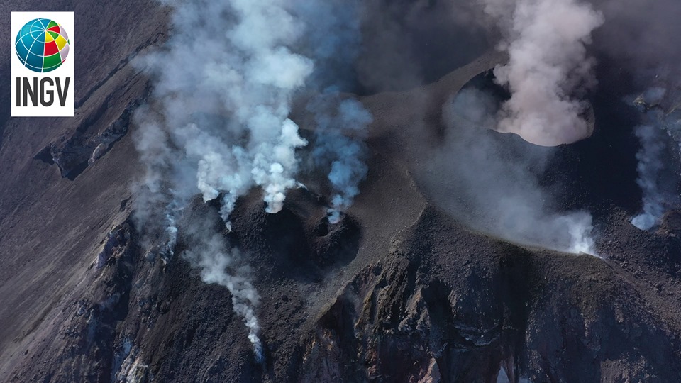
As observed during the inspection in the summit area on August 7, at least 9 vents are active in the North Crater Zone (Zone N), 3 of which form well-structured ash cones. These mouths produce Strombolian activity of low to medium intensity (h 150 m). In the south-central crater area, a large slag cone is clearly visible from the summit area, which generates medium to high explosions rich in pyroclastic material. The lightest part of the jets reaches a height greater than 200 m, while the coarse part does not exceed this height.
The analysis of the images recorded by the cameras placed at 400 meters allowed to analyze the explosive activity with precision until August 8th. During the days analyzed, the images revealed that the mouths of the northern crater area produced explosions of low intensity (less than 80 m high) to medium (less than 150 m high) emitting coarse materials (lapilli). and bombs) with an average frequency varying between 14 and 17 events / h. The mouths of the CS crater exhibited explosive activity of variable intensity ranging from low (less than 80 m high) to high (more than 150 m high) and consisted mainly of pyroclastic material with an average frequency ranging from 4 to 6 events / h. In recent days, it has not been possible to perform an accurate evaluation due to poor weather conditions or a technical problem in camera viewing mode.
https://www.facebook.com/bernhard.strohmeier.9/videos/10216410801074854/
With regard to effusive activity, it was noted during the inspection of 7 August that the lava overflow from the CS crater terrace remained confined to the upper part of the Sciara del Fuoco, between 500 and 600 m above sea level. ‘altitude. We observed along the Sciara del Fuoco that the block rolling due to the materials collapsed both from the active edges of the casting and from the unstable parts. During an inspection carried out on August 8 by a volcanological guide, it was possible to better detail the development of lava flows in the area of the summit where it was possible to observe an overflow of lava from the mouth. In addition, the images of the thermal camera at Punta dei Corvi and Q190 showed that the share of the lava fronts had settled in the upper part of the Sciara del Fuoco.
Source : INGV.
Photo : The photo is taken from a film made by drone, by researchers and technicians of the INGV.
Video : Bernhard Strohmeier
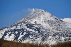
Japan , Asamayama :
36.406°N, 138.523°E
Elevation 2568 m
JMA reported that at 2208 on 7 August a small phreatic eruption at Asamayama produced an ash plume that rose higher than 1.8 km above the crater rim and drifted N. Blocks were ejected 200 m from the crater. The eruption lasted about 20 minutes and was the first since 19 June 2015. The Alert Level was raised to 3 (on a scale of 1-5). Ash fell in Tsumagoi Village and Naganohara Town, in the Gunma Prefecture.
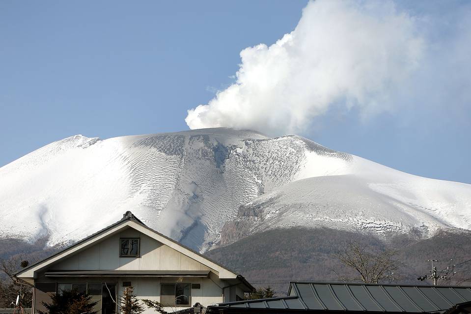
White plumes rose as high as 700 m above the crater rim during 8-13 August, and the amount of sulfur dioxide released was 90-200 tons per day.
Source:Japan Meteorological Agency (JMA) , GVP .
Photo : Auteur inconnu.
Mexico , Popocatepetl :
August 14, 11:00 am (August 14, 16:00 GMT)
In the last 24 hours, thanks to the surveillance systems of the Popocatepetl volcano, 160 exhalations have been identified, accompanied by steam, gas and ash, which the winds have scattered preferentially towards the West and 548 minutes of tremor of weak amplitude. In addition, 16 explosions were recorded, including seven yesterday at 09:33, 13:25, 16:00, 16:38, 17:35, 20:44 and 23:27, the others today. at 00:15, 01:28, 02:12, 02:35, 02:50, 03:16, 06:20, 07:13 and 08:46 h.
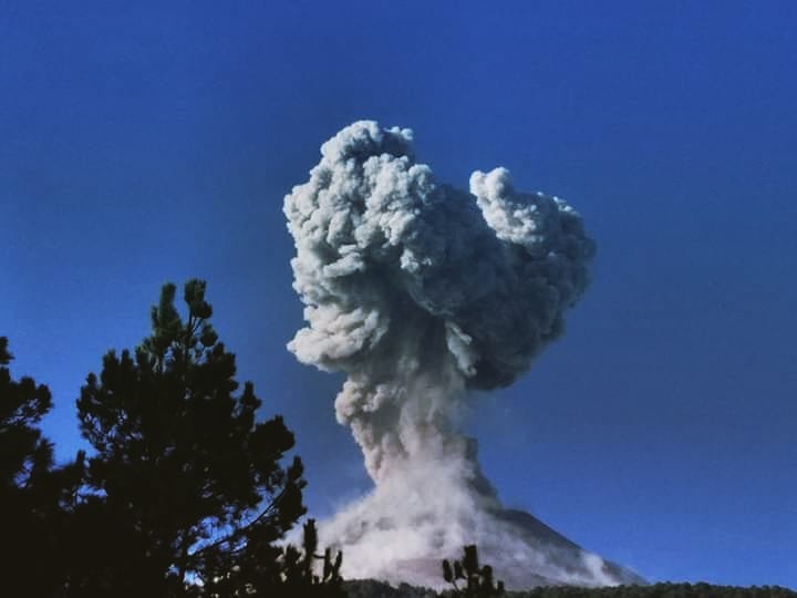
As of this morning and at the time of this report, the volcano is visible and there is a continuous emission of water vapor, gas and ash that the wind disperses to the North-West. Due to the activity presented, ash falls are recorded in the municipalities of Juchitepec, Ayapango and Ozumba, in the State of Mexico.
CENAPRED urges NOT to approach the volcano and in particular the crater because of the risk of falling ballistic fragments, and in case of heavy rains to stay away from the bottom of the ravines due to the risk of mudslides and debris.
The warning light of Popocatépetl is in YELLOW PHASE 2.
Source : Cenapred.
Photo : volcan popocatepetl