July 08 , 2019.
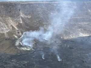
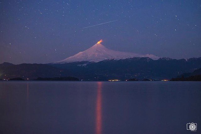
Chile , Villarica :
During this period, 19 volcano-tectonic (VT) seismic events were recorded associated with rock fracturing. The event that presented the greatest energy had a local magnitude of M 2.2, and was located 3.9 km east-southeast of the active crater and at a depth of 4.0 km.
In addition, a total of 5585 long-period (LP) seismic events were recorded, in relation to fluid dynamics within the volcano, with maximum reduced displacement values of 26.7 cm2.
Lastly, the volcanic tremor signal, a seismic signal also associated with the dynamics of the fluids inside the volcano during the period considered, remained the same as in previous periods with reduced displacement values of up to 4 cm2. . The dominant frequencies are maintained mainly between 1 and 3 Hz.
The images recorded with the IP cameras installed near the volcano, when the weather conditions allowed it, showed degassing of predominantly whitish color; this one did not exceed 150 m above the summit .It stands out an episode of height of emission column at 450 m, dated June 14th. . In addition, a night glow is recorded, when weather conditions allowed it to be observed sporadically from the crater.
According to data provided by 5 GNSS stations and two (2) electronic inclinometers, there were no lasting variations and due to changes in the internal dynamics of the volcano.
According to the data provided by the differential absorption optical spectrometry equipment (DOAS), Los Nevados and Tralco stations, located 10 km east-north-east and 6 km east-southeast of the crater On the active side, sulfur dioxide emission values of 1022 +/- 135 t / d were recorded, with a maximum value of 1392 t / d reported on 3 June. These values are considered as usual for this volcano.
During the period 2 thermal warnings were reported on the volcano, with a maximum observed volcanic radiative power (VRP) of 1.0 MW as of June 17, which is considered moderate, according to the data processed by Observation of volcanic activity (Mirova) (http://www.mirovaweb.it/).
The volcanic system maintains seismicity levels similar to previous months, with LP seismic activity correlating with the crater energy fluctuations involved in the lava lake in the latter. Other monitoring parameters such as deformation and concentration of SO2 gas suggest that the volcanic system retains its equilibrium. It is noted that the dynamics of the lava lake located in the main crater of the volcano is fluctuating and that it continues to be located near the surface, causing the occurrence of minor explosions affecting the environment of the crater.
Therefore, the alert level stays at the level:
GREEN LEVEL: Active volcano with stable behavior – No immediate risk – Time for possible eruption: MONTH / YEARS.
Observation: Due to the fluctuating dynamics of the lava lake, it is recommended to apply precautionary access restrictions to an area close to the crater with a radius of 500 m.
Source : Sernageomin.
Photos : Auteur inconnu , horadelaluz_martinifotografia.
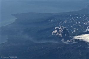
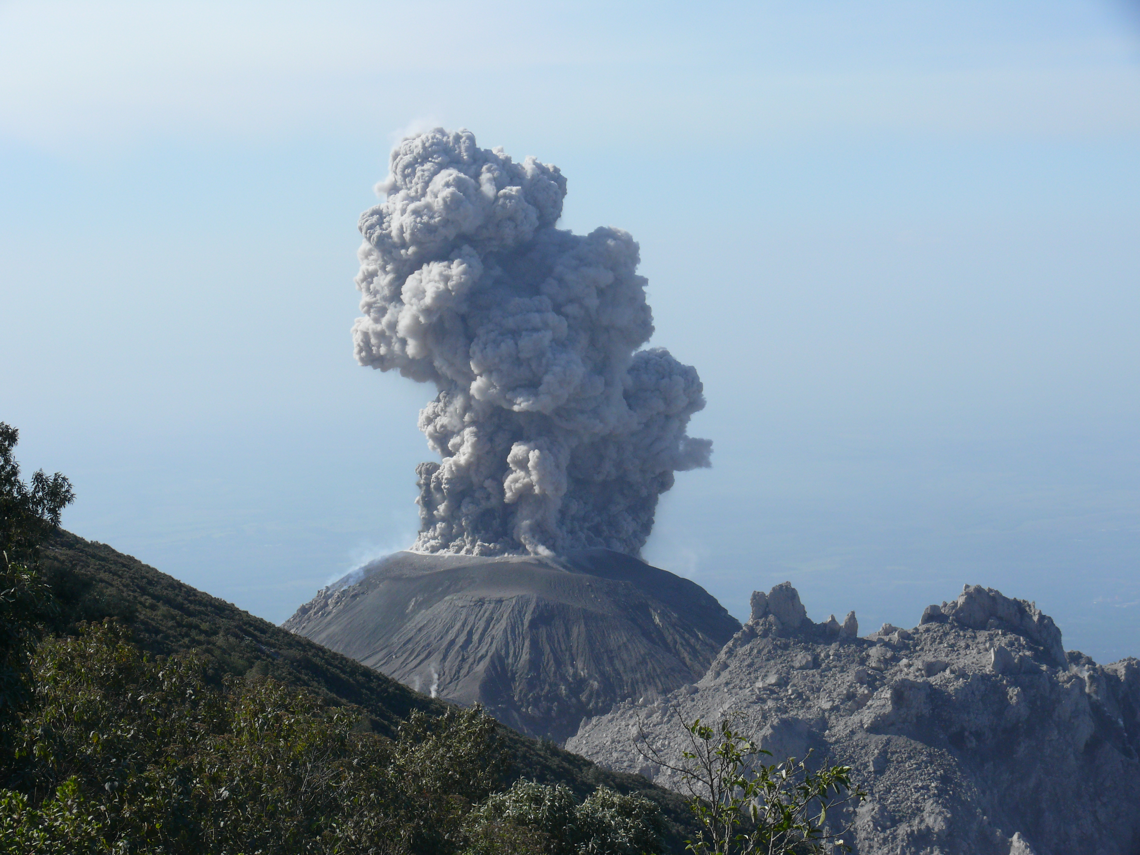
Guatemala , Santiaguito :
Activity type: Pelean
Morphology: Complex of dacitic domes
Geographical location: 14 ° 44 ’33 ˝ Latitude N; 91 ° 34’13˝ Longitude O.
Height: 2,500msnm.
Weather conditions: cloudy
Wind: East at 5 km / h
Precipitation: 0.0 mm
Note:
The parameters described below follow the activity noted in Special Bulletin No. 46-2019, in which activity of the Santiaguito volcano has been reported in recent days.
Activity:
Presence of a white degassing up to 3,000 m altitude and dispersing to the southwest, there are 2 to 3 weak to moderate explosions per hour that raise ash columns to a height of 3,000 to 3 300 m of altitude (9840-10825 feet) and which are dispersed towards the South-West. Falling ash particles are generated in the Monte Claro finca. The explosions generate sounds similar to those of an airplane turbine audible at 5 km distance with time of 3 min. At dawn there was an incandescent on the south-east and north-east edges of the dome. Small, moderate, and strong avalanches occur on the east, south-east, and south flanks that lift materials toward the base of the dome.
Source : Insivumeh.
Photo : Auteur inconnu.
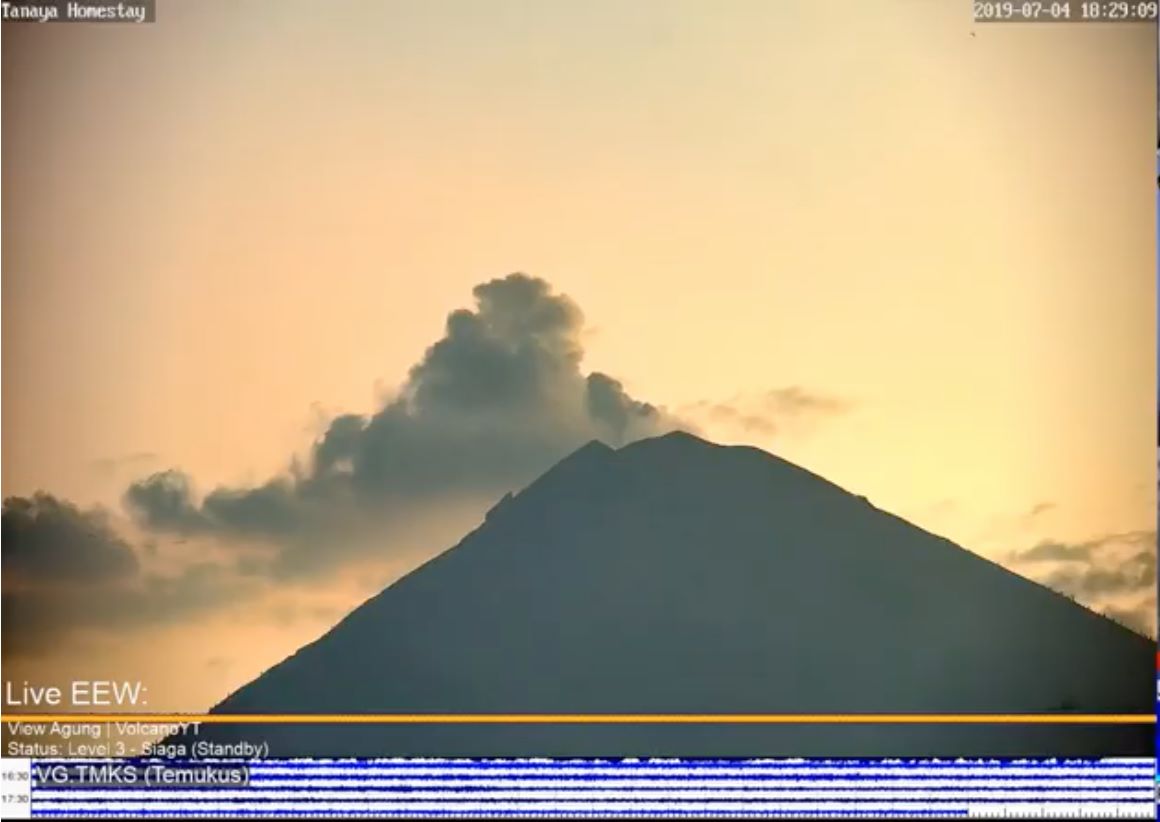
Indonesia , Agung :
This week, there is no effusive or explosive eruption. The visual observations of the volcano during the week are clear, but not visible in the fog / clouds / rains. It is generally observed that the smoke from the crater is thin and gray-white in color and reaches a height of 300 meters above the summit.
The Agung volcano has resumed an eruption phase from 21 November 2017 to today, after having rested more than 53 years. The current level of activity is Level III (SIAGA).
Since yesterday and until this morning, the volcano was covered with fog. It was possible to observe the smoke from the crater, white, at a height of 50-100 meters above the summit. The winds were weak and oriented to the west.
The seismographs of July 7, 2019 recorded:
2 earthquakes of explosions
2 distant tectonic earthquakes
On July 8, 2019 (00: 00-06: 00 WITA) it was recorded:
2 earthquakes of explosions
2 distant tectonic earthquakes
Recommendation:
Communities around G. Agung and mountaineers / visitors / tourists must not climb, climb or carry out any activity within the estimated risk zone, ie in all areas within 4 km radius of Mount Crater. Agung.
People who live and move around rivers downstream of Gunung Agung are aware of the potential secondary threat of lahar raids.
VONA:
The latest code VONA received the color code ORANGE, published on June 13, 2019 at 01:48 WITA, related to the eruption of June 13, 2019 at 1:38 WITA. The column of ash was not observed. The eruption was recorded on a seismogram with a maximum amplitude of 30 mm and an earthquake duration of 3 minutes 53 seconds.
Source : PVMBG
Photo : EEW , 04/07.
El Salvador , San Miguel ( Chaparrastique ) :
Special report 4. Decrease in the activity of the Chaparrastique volcano.
The Chaparrastique volcano showed a decrease in seismic activity and no gas plume was observed, indicating that degassing inside the volcanic system has decreased considerably and tends to equilibrate.
From June 30 until the publication of this report, the seismicity of the volcano shows a clear downward trend, indicating that the internal system of the volcano has eased.
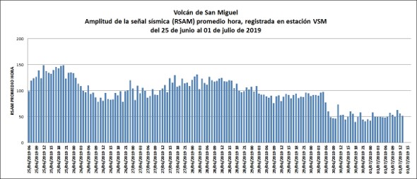
During the last 24 hours, seismic vibration values (RSAM) tend to decrease and fluctuate between 41 and 94 units, with an average hourly of 69 units when the threshold is 150 units.
Similarly, the network of local observers in the area indicates that the volcano is calm.
Analysis of the current situation:
The volcano shows a decrease in its activity, seismicity (RSAM) and the emission of gas, because the system has been balanced. However, as it did on earlier dates, this volcano could show a sudden change in its activity, which would be an indicator of a new rise in fluids, which could lead to a further increase in its activity.
The MARN continues the systematic monitoring of the volcano and maintains close communication with the Directorate General of Civil Protection and local observers. It also calls on locals, tourists and mountaineers to stay away from the crater as the volcano undergoes sudden changes in its activity with emission of gas and small amounts of ash.
This is the last special report of the series that began on Friday, June 21, 2019, during which time the volcano maintained an increase in its seismic activity, without observing gas plume.
If new changes indicating an increase in activity are detected, they will be reported promptly.
Source : Marn.
Photo : Auteur inconnu