May 08 , 2019.
Decidedly, I’m out of luck, power failure yesterday. Someone put a spell on me …
Indonesia , Sinabung :
VOLCANO OBSERVATORY NOTICE FOR AVIATION – VONA.
Issued: May 07 , 2019
Volcano: Sinabung (261080)
Current Aviation Colour Code: ORANGE
Previous Aviation Colour Code: unassigned
Source: Sinabung Volcano Observatory
Notice Number: 2019SIN01
Volcano Location: N 03 deg 10 min 12 sec E 98 deg 23 min 31 sec
Area: North Sumatra, Indonesia
Summit Elevation: 7872 FT (2460 M)
Volcanic Activity Summary:
Eruption with ash clouds at 23:41 UTC (06:41 local time). The eruption lasted for 2569 seconds.
Volcanic Cloud Height:
Best estimate of ash-cloud top is around 14272 FT (4460 M) above sea level, may be higher than what can be observed clearly. Source of height data: ground observer.
Other Volcanic Cloud Information:
Ash cloud is moving to Southwest.
Remarks:
Seismic activity is characterized by Gas Emission. Rock avalanche (Incandescent lava) is not identified.
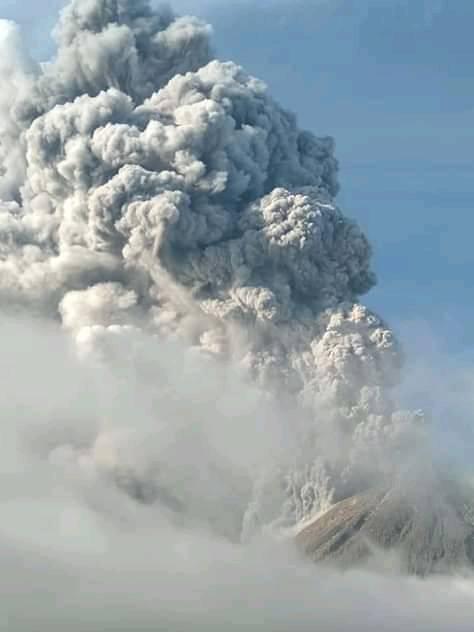
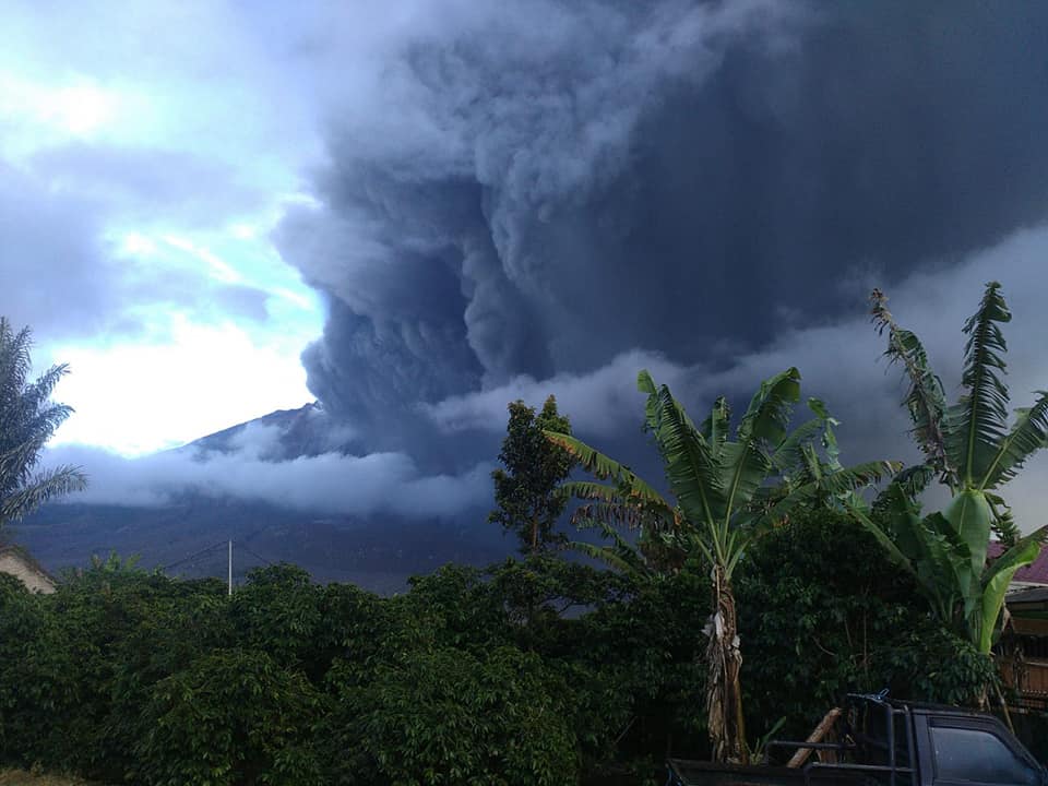
An eruption of Mount Sinabung, North Sumatra, occurred on 7 May 2019 at 07:48, with the height of the ash column observed ± 2,000 m above the summit (± 4,460 m above sea level) ). The column of ash was gray, of thick intensity and inclined towards the South-East. This eruption was recorded on a seismogram of maximum amplitude of 120 mm and a duration of ± 42 minutes 49 seconds.
Ash emissions are still in progress
Currently, G. Sinabung is at Activity Level IV (SIAGA) with recommendations:
– The community / visitors must not practice activities within a radius of 3 km for the North-West sector, 4 km for the South-West sector, 7 km for the South-South-East sector, within a radius of 6 km for the South-East sector and within a radius of 4 km. km for the North-East sector
– Communities living along the rivers below Mount Sinabung should be aware of the potential of lahars, especially during heavy rains.
Source : Magma Indonésie , PVMBG.
Photos : Irma Bulan Hutasuhut Irma ( 07/05/2019 ) , Marice Sagala ( 07/05/2019 ).
Guatemala , Fuego :
VOLCANOLOGICAL SPECIAL BULLETIN BEFGO No. 14-2019, Guatemala, May 3, 2019 at 8:55 pm (local time).
LAHAR MODERE IN THE RAVINE LAS LAJAS.
Type of activity: Vulcanian
Morphology: Composite Stratovolcano
Geographical location: 14 ° 28’54˝ Latitude N; 90 ° 52’54˝Longitude W.
Height: 3,763msnm.
Precipitation during the afternoon in the Fuego Volcano region is currently generating a descent of lahars with moderate features in the Las Lajas Canyon (tributary of the Guacalate River). The precipitation recorded by the FG12 station at this time is 26.2 mm.
This lahar has moderate characteristics, conveys pasty materials with blocks of different sizes, branches and tree trunks.
Due to the rains that can be generated during the night and early morning in the vicinity of the volcano, the possibility of lahars in one of the main ravines is not excluded.
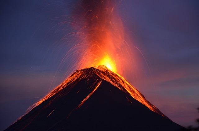
Activity:
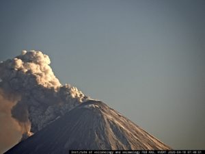
Presence of white degassing fumaroles at a height of 4200 meters (13780 feet), dispersing to the north and north-west. They generate 12 to 15 explosions per hour, low to moderate, which expel columns of gray ash to an altitude of 4,600 to 4,700 meters, dispersing about 15 kilometers to the north and northwest. At night and early in the morning, incandescence was observed between 200 and 350 meters above the crater, generating weak to moderate avalanches on the crater contour towards the Seca, Taniluyá, Ceniza, Trinidad and Las Lajas ravines. Incandescent materials descend to the vegetation. Low to moderate rumblings are perceived which give rise to weak shock waves, causing vibrations in the roofs of dwellings, mainly in the communities to the west and southwest. Degassing sounds are perceived with a lapse of time between 10 and 20 minutes. Lava flows are heading to the Seca ravine on the western flank of an approximate length of 700 meters.
Source : Insivumeh
Photo : Nath Duverlie , 05/05/2019
Kamchatka , Karymsky :
VOLCANO OBSERVATORY NOTICE FOR AVIATION (VONA).
Issued: May 7 , 2019
Volcano:Karymsky (CAVW #300130)
Current aviation colour code:ORANGE
Previous aviation colour code:orange
Source:KVERT
Notice Number:2019-90
Volcano Location:N 54 deg 2 min E 159 deg 26 min
Area:Kamchatka, Russia
Summit Elevation:4874.08 ft (1486 m)
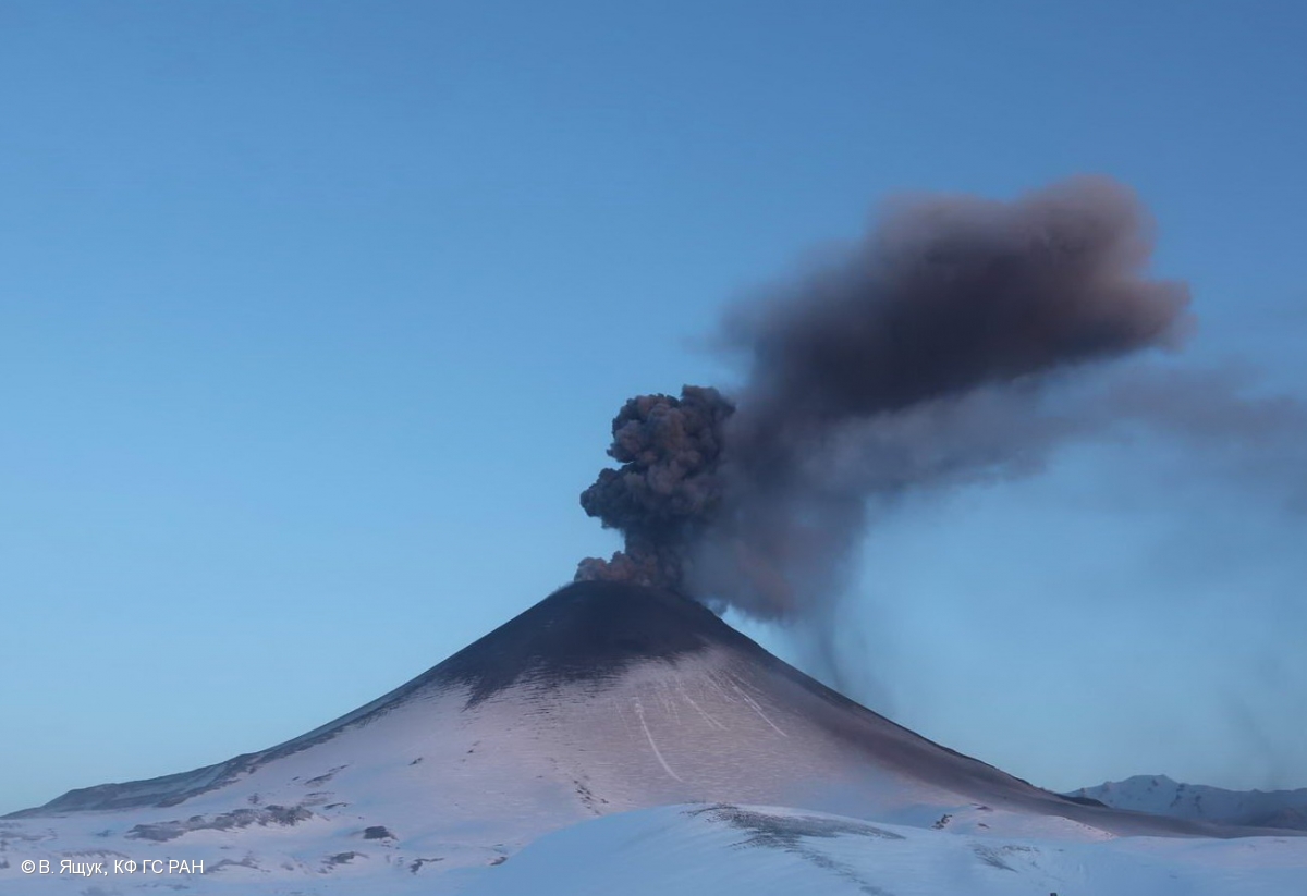
Volcanic Activity Summary:
Satellite data shows an ash plume is extending about 105 km to the south-east from volcano.
A moderate eruptive activity of the volcano continues. Ash explosions up to 13,100-19,700 ft (4-6 km) a.s.l. could occur at any time. Ongoing activity could affect low-flying aircrafts.
Volcanic cloud height:
6560-7216 ft (2000-2200 m) AMSL Time and method of ash plume/cloud height determination: 20190507/0620Z – Himawari-8
Other volcanic cloud information:
Distance of ash plume/cloud of the volcano: 65 mi (105 km)
Direction of drift of ash plume/cloud of the volcano: ESE / azimuth 122 deg
Time and method of ash plume/cloud determination: 20190507/0620Z – Himawari-8
Source : Kvert.
Photo : 24/3/2015 , V. Yaschuk, KB GS RAS
Peru , Sabancaya :
Analysis period: April 29 to May 5, 2019, Arequipa, May 6, 2019.
Alert level: ORANGE
The Geophysical Institute of Peru (IGP) reports that the eruptive activity of the Sabancaya volcano remains moderate, following the analysis of seismic information and cortical deformation, as well as satellite and visual observations. Therefore, for the following days, no significant change is expected.
The analysis of records obtained by the seismic network of the Sabancaya volcano for the period from April 29 to May 5, 2019 has identified the occurrence of about 1750 earthquakes, the highest percentage being associated with the movement of magmatic fluids. Earthquakes caused by the rise of magma remain few and the energy released remains low. During the same period, an average of 20 daily explosions were recorded, of medium to low intensity

The monitoring of the deformation of the volcanic structure (GPS stations) does not present anomalies. The visual surveillance, using surveillance cameras, identified the appearance of eruptive columns up to 3 km high on the summit of the volcano, whose ashes were dispersed to the eastern and south-eastern sectors of the volcano. volcano. Satellite monitoring identified 8 volcanic anomalies on the volcano ranging from 1 to 22 MW, associated with the presence of a hot body near the surface and the persistence of explosions.
Source : IGP
Photo : Ingemmet.
Colombia , Nevado del Huila :
Popayán, May 7, 2019, at 5.30 pm Weekly activity bulletin of the Nevado del Huila volcano.
The level of activity of the volcano continues at the level: yellow activity level or (III): changes in the behavior of volcanic activity.
Based on the analysis and evaluation of information obtained through the monitoring network of the Nevado del Huila volcano, from April 30 to May 6, 2019, the GEOLOGICAL SERVICE OF COLOMBIA – Volatological and Seismological Observatory of Popayán informs that:
During the evaluated period, 126 seismic events were recorded, 89 related to rock fracturing processes (type VT) and 37 related to fluid dynamics in volcanic canals. Of these, 34 were classified as long-period type events (LP type) and three (3) as low-energy tremor pulses (TR type). Among the seismicity associated with fracture processes, it should be noted that most events continue to be recorded north-east of the volcanic building, at a distance from the central peak of between 9 and 21 km and at depths between 6 and 6 km. and 12 km.
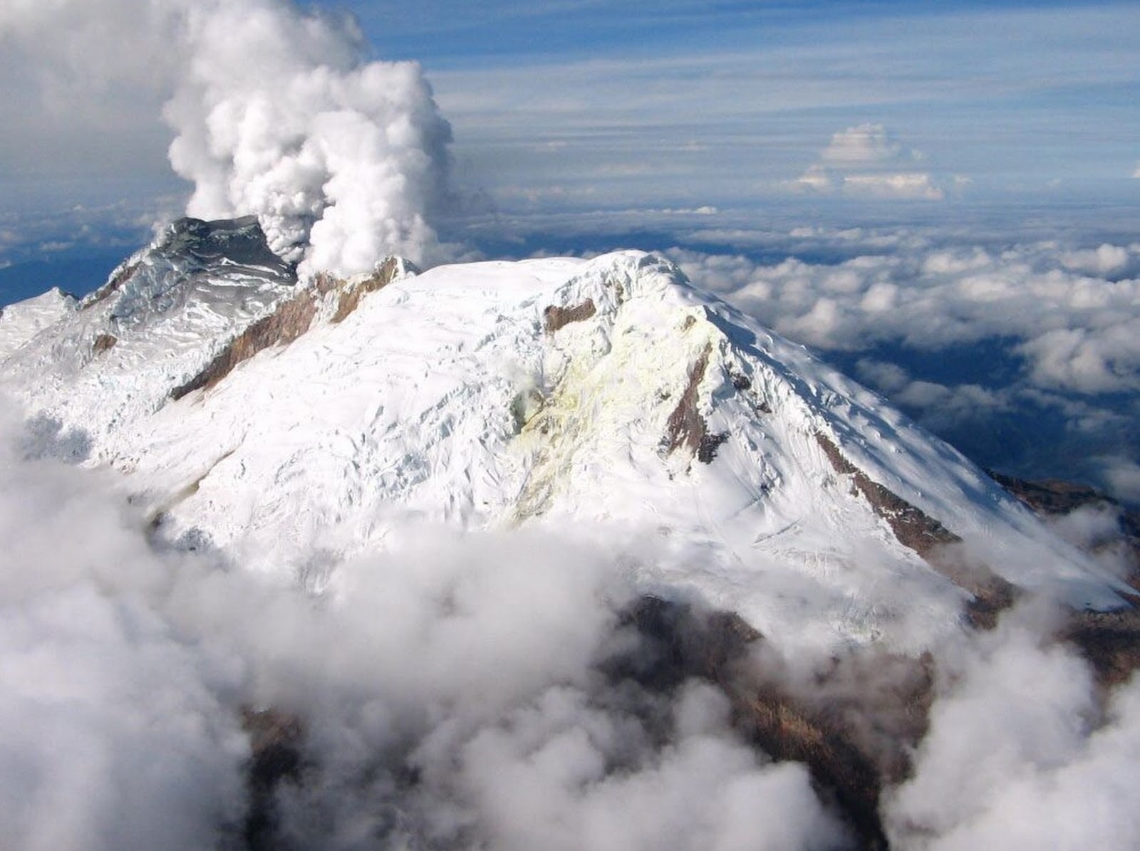
The images obtained during the week by the web cameras of Caloto, Tafxnú, Maravillas and La Palma showed a weak degassing of the volcanic system.
Sensors for monitoring soil deformation, magnetic fields and infrasound waves have not recorded any variations associated with changes in volcanic activity.
It is repeated that, although the VT seismicity located to the northeast of the Nevado del Huila volcano is in its zone of influence, these events are generated in a tectonically active zone and have so far not affected the other parameters. volcanic monitoring. The level of activity of the volcano has therefore not changed, which continues at the level of Amarillo activity or level III.
Source : SGC
Photo : Parque-Nacional-