February 26 , 2018.
Mayon , Philippines :
MAYON VOLCANO BULLETIN 26 February 2018 08:00 A.M.
Mayon’s condition for the past 24 hours was characterized by weak lava fountaining, lava effusion and degassing from the summit crater. As of 7:04 AM this morning, a total of thirty six (36) discrete episodes of lava fountaining lasting two (2) to nineteen (19) minutes have occurred, accompanied by booming and rumbling sounds audible beyond 10 kilometers of the summit crater. Lava fountains 50-200 meters tall generated steam-laden plumes that rose to 150-600 meters from the summit before drifting southwest, west-northwest, northwest, and northeast. In the evening, lava effusion from the vent was observed to continue feeding lava flows that have maintained fronts at 3.3 kilometers, 4.5 kilometers and 900 meters on the Miisi, Bonga and Basud Gullies, respectively, from the summit crater. Only two (2) episodes of lava-collapse pyroclastic density currents (PDC) were visually observed between 10:33 AM and 10:38 AM yesterday on the Miisi, Basud and Bonga-Buyuan Gullies within 4 kilometers of the summit crater.
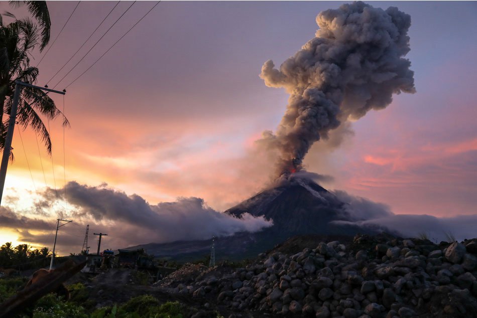
A total of one hundred twenty-four (124) volcanic earthquakes and one (1) rockfall event were recorded by Mayon’s seismic monitoring network. Sulfur dioxide (SO2) emission was measured at an average of 2070 tonnes/day on 23 February 2018. Deflation of the lower slopes that began on 20 February was recorded by electronic tilt, consistent with the transition to quiet lava effusion at the summit crater, a brief lull and resumption of sporadic fountaining. Nonetheless, overall electronic tilt and continuous GPS data indicate that the edifice is still swollen or inflated relative to November and October 2017, consistent with campaign Precise Leveling data acquired this week.
Alert Level 4 still remains in effect over Mayon Volcano. The public is strongly advised to be vigilant and desist from entering the eight (8) kilometer-radius danger zone, and to be additionally vigilant against pyroclastic density currents, lahars and sediment-laden stream flows along channels draining the edifice. Civil aviation authorities must also advise pilots to avoid flying close to the volcano’s summit as ash from any sudden eruption can be hazardous to aircraft.
DOST-PHIVOLCS maintains close monitoring of Mayon Volcano and any new development will be communicated to all concerned stakeholders.
Source : Phivolcs.
Photo : Jonathan Cellona ( 25 Janvier 2018)
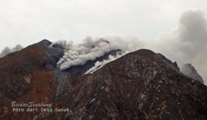
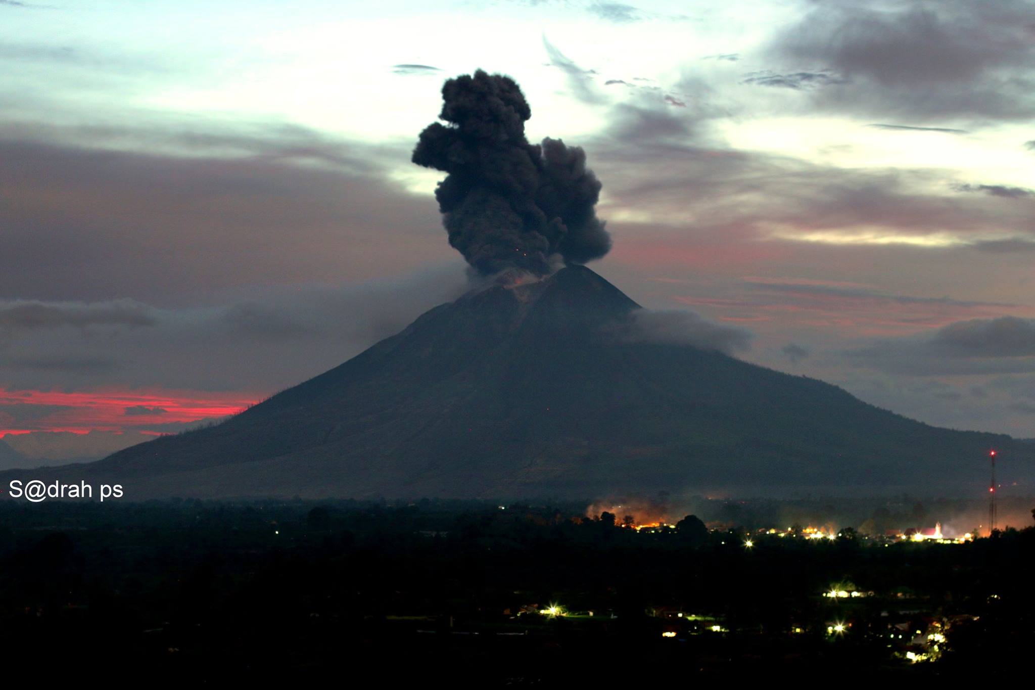
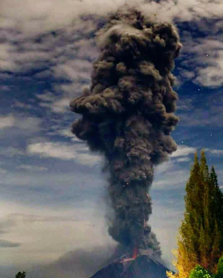
Sinabung , Indonesia :
VOLCANO OBSERVATORY NOTICE FOR AVIATION – VONA.
Issued: February 25, 2018.
Volcano: Sinabung (261080)
Current color code for aviation: RED
Previous aviation color code: red
Source: Sinabung Volcano Observatory
Number of reviews: 2018SIN90
Location of the volcano: N 03 deg 10 min 12 sec E 98 deg 23 min 31 sec
Region: North Sumatra, Indonesia
Altitude of the summit: 7872 ft (2460 m)
Summary of volcanic activity:
Eruption with ash clouds at 13:30 UTC (20:30 local time). The eruption lasted 610 seconds.
Height of the volcanic cloud:
The best estimate of the ash cloud summit is about 20032 feet (6260 M) above sea level, may be higher than can be clearly seen. Height data source: ground observer.
Other information about the volcanic cloud:
The ash cloud moves to the south-southwest
Remarks:
The seismic activity is characterized by deep volcanic earthquakes, low frequency earthquakes and hybrid earthquakes. Warm clouds are observed on the South-South-East slope and reach a distance of 2000 meters from the summit.
Level IV Activity Level (AWAS). The Sinabung (2460 m altitude) has been erupting constantly since 2013.
Since yesterday until this morning the volcano has been observed until it is covered with fog. The smoke coming out of the crater could be observed in white / gray color, with a height of 100 to 1000 m above the summit. An explosive eruption was observed, with strong pressure, where the height of the thick gray ash columns was observed and reached 3800 m above the peak. The eruption was accompanied by emission of hot clouds with sliding distances, to the southeast and south up to 500 m. The eruption lasted 610 seconds. The wind is blowing low to moderate in the South, in the West in the Southwest and in the North.
According to the seismographs , on February 25, 2018, it has been recorded:
1 eruption earthquakes
3 earthquakes of emission.
1 distant tectonic earthquakes.
8 low frequency earthquakes
1 phase / hybrid earthquake
1 shallow volcanic earthquake (VB)
5 deep volcanic earthquakes (VA)
A continuous tremor (microtremor) with an amplitude of 0.5-17 mm (dominant value of 8 mm)
Recommendations:
Communities / visitors should not do activities within 3 km of the summit, and by sector, 7 km to the South-South-East, 6 km East-South-East and 4 km to the South-East. km northeast.
The deposits formed a dam upstream on the Laborus River. People living in downstream river basins and around the Laborus River need to be vigilant because these dams can collapse at any time and no longer retain water volume, resulting in downstream lahars / floods .
Source : Magma , VSI.
Photos : Sadrah Peranginangin, Peter Rendez Vous.
San Miguel ( Chaparrastique ) , El Salvador :
Special Report No. 2: The activity of the Chaparrastic volcano tends to stabilize.
Date and time of publication: 2018-02-23 15:00:00.
The activity of the Chaparrastic volcano, reflected by seismicity and the emission of sulphurous gas, tends to decrease. During the last 24 hours, the seismic vibration has varied between 81 and 182 RSAM units, with an average of 113 units (Figure 1), the normal value being between 50 and 150 RSAM units / hour on average.

Figure 1. Low seismic vibration
At 08:58 on February 23, the volcano was calm and without the presence of a gas plume
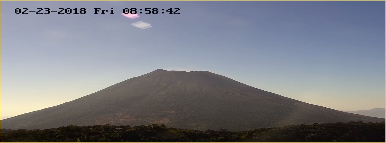
Figure 2. Current state of the volcano at 08:58 (23/02/2018)
Although the trend is downward, sulfur dioxide emissions are above the threshold of 620 tonnes per day (Figure 3). What is observed seems to indicate anomalies in the tank, so that the appearance of gas pulses and ash emissions are not excluded as reported previously.

Figure 3. Behavior of volcanic gas flow to date in 2018
In conclusion, the seismicity of the volcano showed a downward trend, being convergent with the decrease of the emission of gas. However, periodic changes in seismicity and degassing suggest the presence of fluids in the system, so it is not excluded that changes will occur in the future.
MARN continues the systematic monitoring of the volcano and maintains close communication with the Directorate General of Civil Protection and local observers. In addition, it invites tourists and mountaineers to stay away from the upper part of the volcano because, often, there are sudden changes in activity. If the activity does not evolve, the next report will be published on Friday, March 2, 2018.
Source : Snet
Popocatépetl , Mexico :
February 25, 11:00 (February 25, 17:00 GMT).
During the last 24 hours, through monitoring systems of the Popocatépetl volcano, 48 low intensity exhalations have been identified, accompanied by water vapor and gas. The most important were observed at 17h55 hours yesterday, and today at 07:14 h and 20h28. , which generated columns of steam and gas from a height of between 800 and 1000 m above the crater. Similarly, a preliminary magnitude volcano-tectonic event of M2.2 has been recorded.
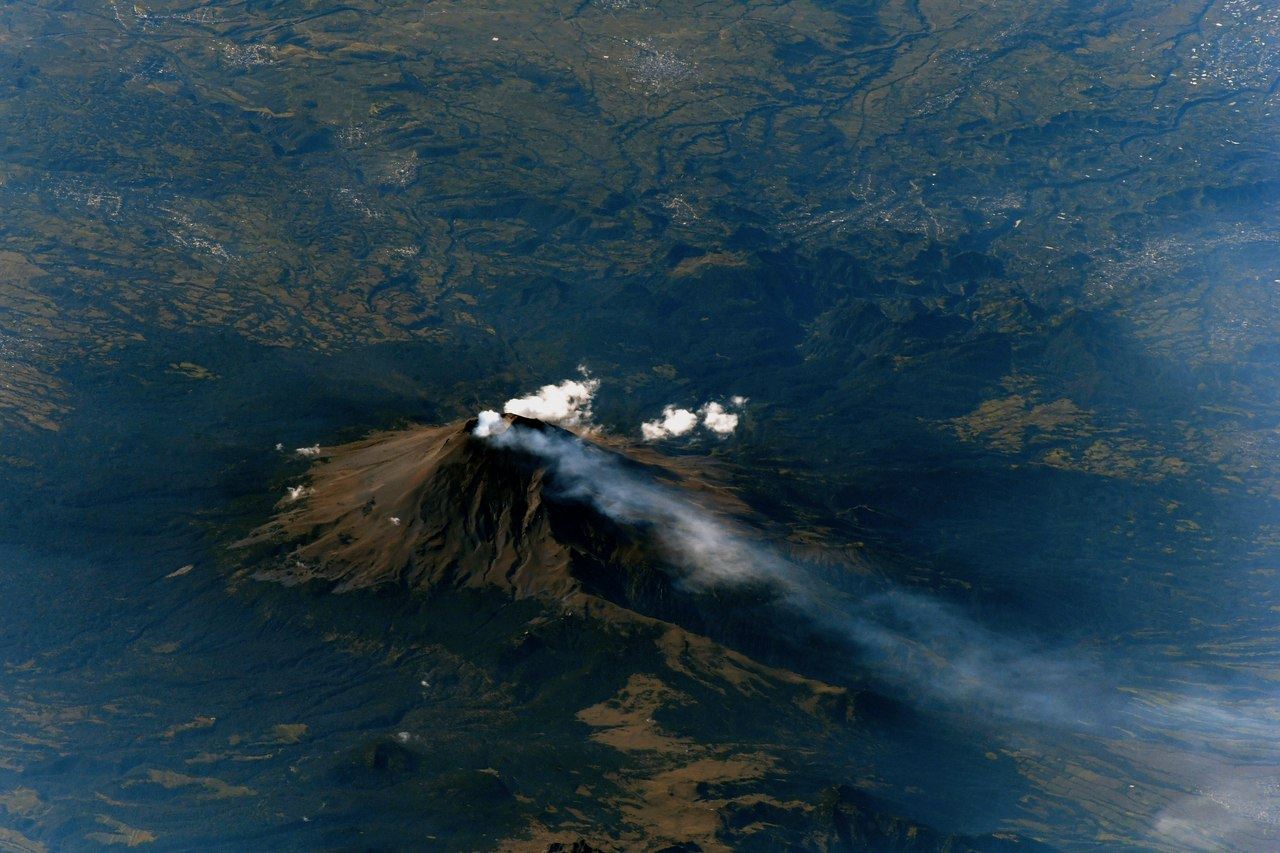
At the time of this report, there is no visibility because of clouds; nevertheless, during the previous hours, a slight emission of water vapor and gas was observed.
CENAPRED asked not to approach the volcano and in particular the crater, because of the risk of falling of projectiles, and in case of heavy rain to remain far from the bottom of the ravines because of the danger of landslides and flows of mud.
The volcanic warning light of the Popocatepetl volcano is located at Amarillo Phase 2
Source : Cenapred .