January 10 , 2026.
Italy / Sicily , Etna :
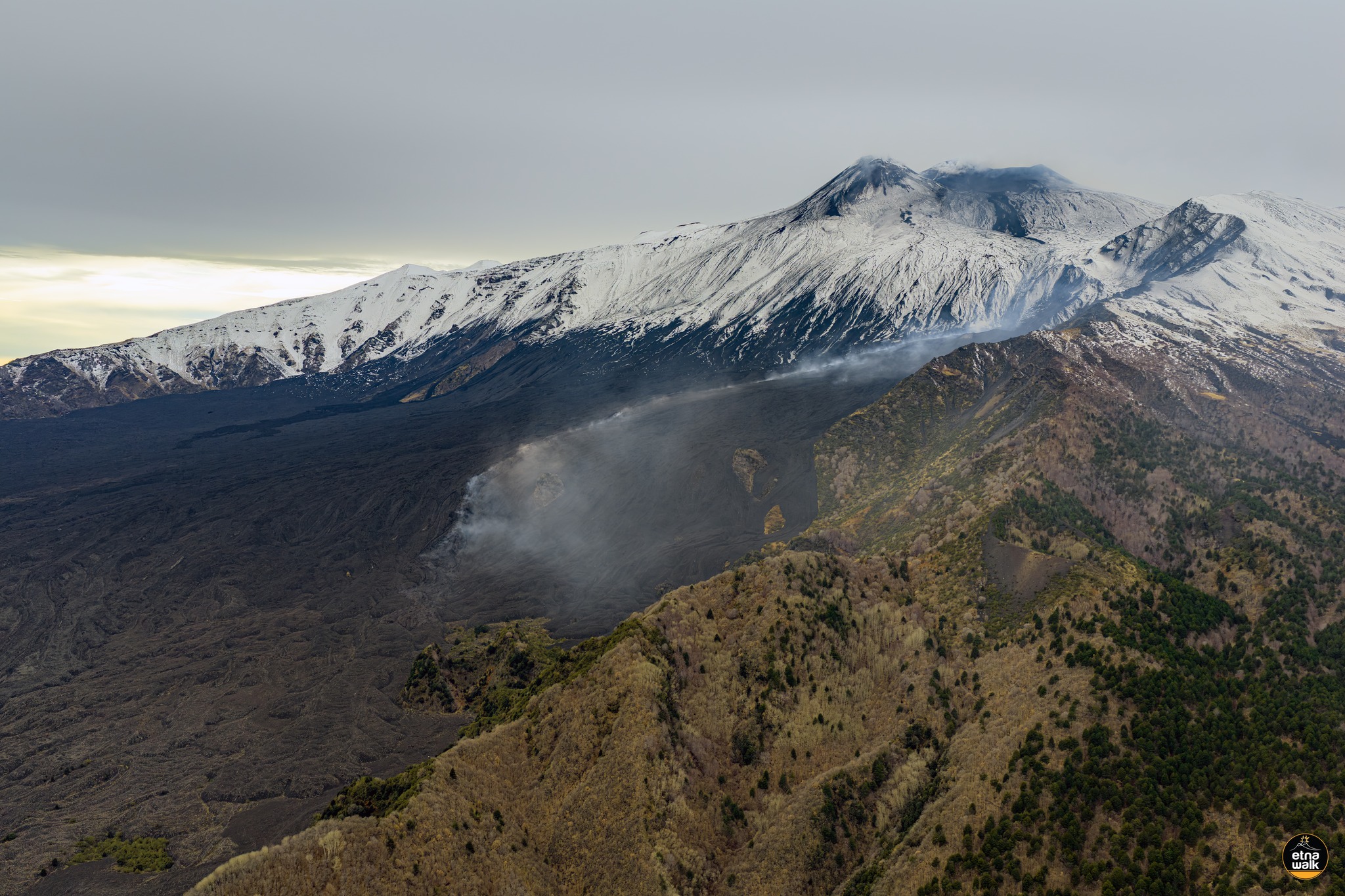
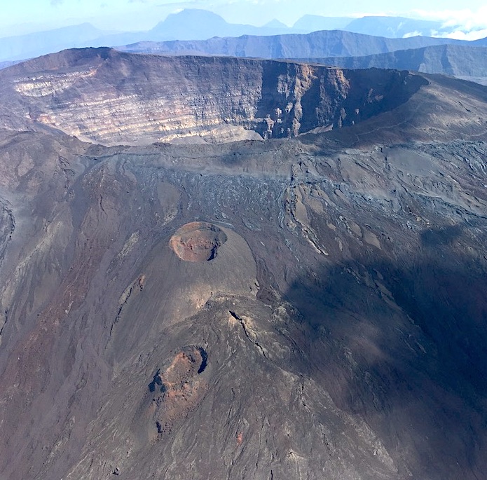
Etna Activity Update, January 9, 2026, 1:52 PM (12:52 UTC).
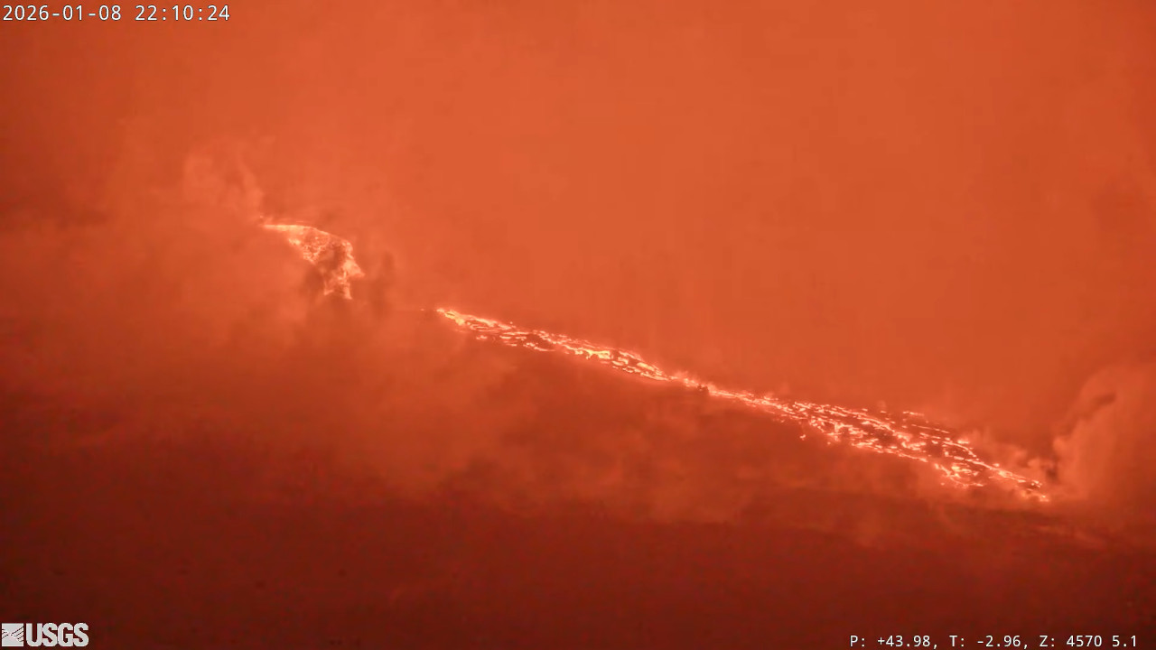
The National Institute of Geophysics and Volcanology (INGV-OE), Etna Observatory, reports that moderate effusive activity continues at the eruptive vents that opened on January 1 in the upper Valle del Bove. During the night, images from the Monte Cagliato surveillance cameras showed continuous flashes at the eruptive vents.
During an inspection carried out this morning by INGV-OE personnel at the eruptive site, several active lava flows were observed near Monte Simone. The most advanced lava front is located at an altitude of a few tens of meters below 1,900 m, and another, further east, is located a few tens of meters below 2,000 m. The lower part of the lava field, where the most advanced lava fronts were located last week, is stationary and cooling. During several hours of fieldwork in the Valle del Bove, INGV-OE personnel did not hear any detonations from the summit craters and only noted significant degassing from the Southeast, Northeast, and Voragine craters.
From a seismic perspective, since last night, the average amplitude of the volcanic tremor has fluctuated between low and medium values. The center of gravity of the volcanic tremor sources is located in the Northeast Crater area, at a depth of between 300 and 700 m above sea level.
Regarding infrasound signals, it was not possible to perform a reliable assessment, either in terms of frequency of occurrence or source location, due to the high noise level caused by poor weather conditions. On January 7, at approximately 2:30 PM UTC, the DRUV extensometer recorded a new phase of rapid compression, with an accumulation of about 20 nanostrains. This phase was followed by slow decompression. Currently, an oscillatory phase is underway, with periods of slow compression and decompression. A similar trend is visible on the ECP inclinometer. No changes have been observed on the GNSS-HF network.
Further updates will be communicated soon.
Source : INGV.
Photo : Giuseppe Distefano / Etna Walk.
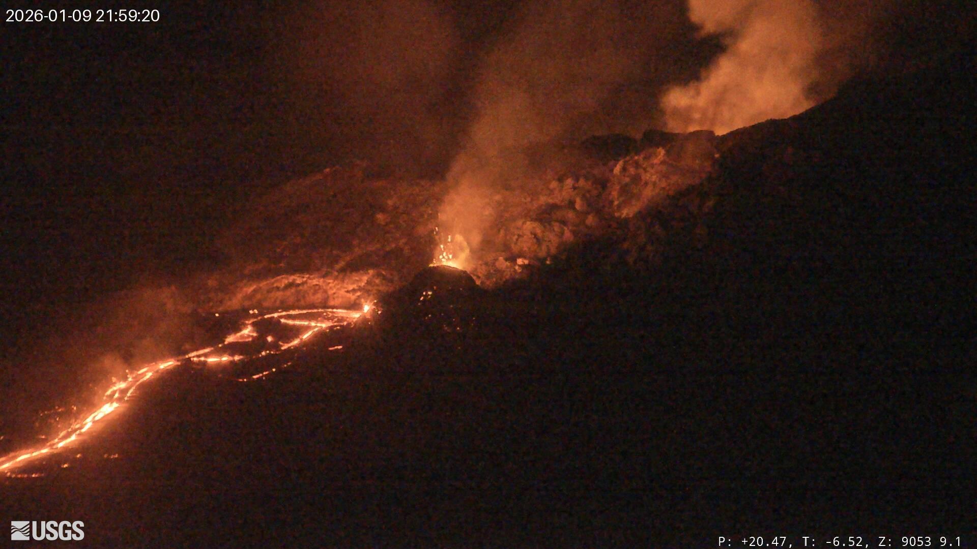
Hawaii , Kilauea :
HAWAIIAN VOLCANO OBSERVATORY DAILY UPDATE , U.S. Geological Survey
Friday, January 9, 2026, 9:25 AM HST (Friday, January 9, 2026, 19:25 UTC)
19°25’16 » N 155°17’13 » W,
Summit Elevation 4091 ft (1247 m)
Current Volcano Alert Level: WATCH
Current Aviation Color Code: ORANGE
Activity Summary:
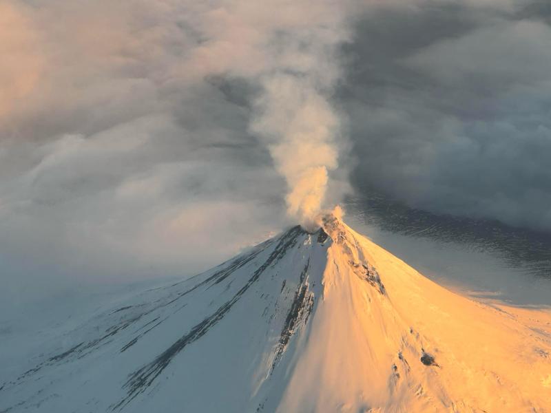
Lava overflowed from the south vent in Halemaʻumaʻu several times overnight and spattering continued to be visible within the north vent. Kīlauea summit region showed slow inflation on tiltmeter UWD over the past 24 hours. Forecasting models suggest the window for lava fountaining episode 40 is between January 10 and 14. Kīlauea’s East Rift Zone and Southwest Rift Zone remain quiet.
Summit Observations:
Glow from the north and south vents was strong overnight. A small tongue of lava briefly overflowed from the south vent at 4:05 p.m., followed by more significant overflows that generated narrow sluggish lava flows from 6:21-6:37 p.m. and 10:02-10:22 p.m. Spatter continued to be occasionally visible within the north vent, though lava did not overflow from the north vent. Seismometers are recording low level tremor from the vent region with poorly defined, weak bursts of tremor 10-20 minutes apart. Since the end of episode 39, the Uēkahuna tiltmeter (UWD) has recorded 21.7 microradians of re-inflation beneath Kīlauea summit, an increase of 0.7 microradians in the past 24 hours.
Volcanic gas emission rates have dropped significantly since the end of episode 39 but probably remain in the range of 1,000 to 5,000 tonnes of sulfur dioxide (SO2) per day, as typically observed during previous eruptive pauses.
Rift Zone Observations:
Rates of seismicity and ground deformation remain very low in the East Rift Zone and Southwest Rift Zone. SO2 emissions from the East Rift Zone remain below the detection limit.
Analysis:
The rapid rebound of inflationary tilt and presence of low-level volcanic tremor after episode 39 indicate that another lava fountaining episode is likely to occur. Spattering was visible in the north vent and lava overflowed from the south vent several times over night, indicating that magma is high in the vents. The UWD tiltmeter has shown slow rates of inflation over the past several days, with brief deflationary pulses that affect the forecast window for the start of episode 40 fountaining. The SDH and SMC tiltmeters have been recording steadily increasing tilt over the past 2 days indicating summit inflation is continuing, possibly in the deeper magma chamber. Forecast models suggest the window for onset of episode 40 fountaining is between January 10 and 14.
Source : HVO.
Photos : USGS.
Alaska , Shishaldin :
Signs of volcanic unrest at Shishaldin Volcano continued this week. Web camera images, when clear, showed a plume of gas rising from the summit crater. Low-level seismic activity has persisted, with small earthquakes occurring daily. Infrasound signals, likely caused by gas bubbles bursting deep within the volcanic vent, were also detected throughout the week when the conditions were not too windy. At this time, there is no evidence of lava at or near the surface.
Shishaldin Volcano is monitored by local seismic and infrasound sensors, web cameras, and a telemetered geodetic network. In addition to the local monitoring network, AVO uses nearby geophysical networks, regional infrasound and lighting data, and satellite data to monitor the volcano.
Source : AVO.
Photo : Reedy, Brian
Chile / Argentina , Planchón-Peteroa :
During the study period, volcano-tectonic (VT) seismic activity, associated with rock fracturing within the volcano, showed an increase in both the number of recorded events and the energy released compared to the previous period.
The most energetic recorded VT event had a local magnitude (ML) of 2.4 and was located 2.8 km north-northwest (NNW) of the volcanic edifice, at a depth of 4.7 km from the active crater.
Seismic activity associated with fluid movement within the volcano, represented by long-period (LP) events and tremors (TR), also showed an increase in both the number of recorded events and the energy released compared to the previous period. The maximum energy released for LP events, recorded by reduced displacement (DR), was 18 cm². For TR events, the maximum reduced displacement (DR) value was 15 cm². Furthermore, the energy of the continuous tremor signal, recorded from the RSAM value and associated with sustained fluid dynamics within the volcano, fluctuated throughout the period, with transient increases and decreases. These values remain above the reference level for this volcano.
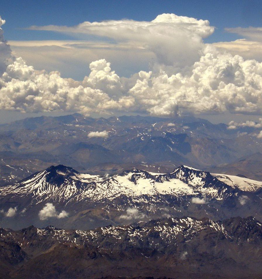
During this two-week period, low-altitude degassing plumes were frequently recorded at the summit of the volcano, reaching heights of less than 500 m above the crater rim. Notably, no nighttime incandescence or pyroclastic material (volcanic ash) emissions were recorded during this period.
For the evaluated period, satellite data processing detected no anomalies in sulfur dioxide (SO₂) emissions in areas near the volcanic edifice.
During the analyzed period, a low-magnitude thermal anomaly was detected on December 2 by VIIRS750, with a peak radiative power (PRP) of 1 MW, according to satellite image processing.
Geodetic monitoring carried out during this period revealed no significant variations related to volcanic activity. Morphological analysis, based on PlanetScope and Sentinel-2 L2A satellite imagery, showed that the emission of gas and water vapor from the Southwest Crater continues. Furthermore, no emissions or deposition of pyroclastic material were recorded during these two weeks.
Source et photo : Segemar.
La Réunion Island , Piton de la Fournaise :
Press release from the Paris Institute of Earth Physics / Piton de la Fournaise Volcanological Observatory, January 9, 2026 – 10:30 a.m. local time – 6:30 a.m. UTC
Seismicity
Seismic activity beneath Piton de la Fournaise continues. Since the magmatic intrusion of January 1, 2026, an average of thirty shallow volcano-tectonic earthquakes per day has been recorded beneath the summit of the volcano. These earthquakes, located between 1.5 and 2.2 km deep, are mainly situated beneath the northern and southern rims of the Dolomieu crater.
At the same time, deep volcano-tectonic seismicity persists, but its low magnitude makes it difficult to locate.
Only one deep event has been located at approximately 9 km deep, beneath the northwest sector of the summit.
This deep seismicity suggests that the supply of magma from deep zones to the volcano’s shallow feeding system continues.
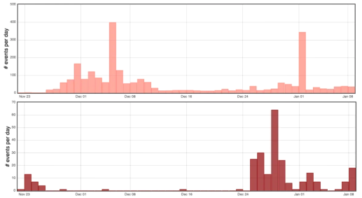
Histogram showing the number of deep (bottom) and shallow (top) volcano-tectonic earthquakes per day recorded since November 22, 2025 (© OVPF-IPGP)
Deformation
After a period of inactivity that began on December 14, inflation (swelling) of the volcano resumed at the end of December, just before the magma intrusion of January 1, 2026. Since this intrusion, inflation has persisted, indicating that the pressurization of the shallow magma reservoir continues.
Overall
Following the magma intrusion of January 1, 2026, seismicity and inflation continue, demonstrating that the magma reservoir remains under pressure. This pressurization process of the shallow reservoir can last from several days to several weeks, or even several months, before the roof of the reservoir ruptures, resulting in an injection of magma towards the surface and potentially an eruption, but it can also stop without leading to an eruption in the short term.
It should be noted that during these pressurization phases, seismic activity under the Piton de la Fournaise can fluctuate from day to day with periods of low seismicity interspersed with periods of higher seismicity.
Niveau d’alerte : Vigilance
Source et photos : OVPF.