January 3 , 2026 .
Italy / Sicily , Etna :
Etna Activity Update, January 1, 2026, 7:22 PM (6:22 PM UTC).
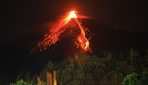
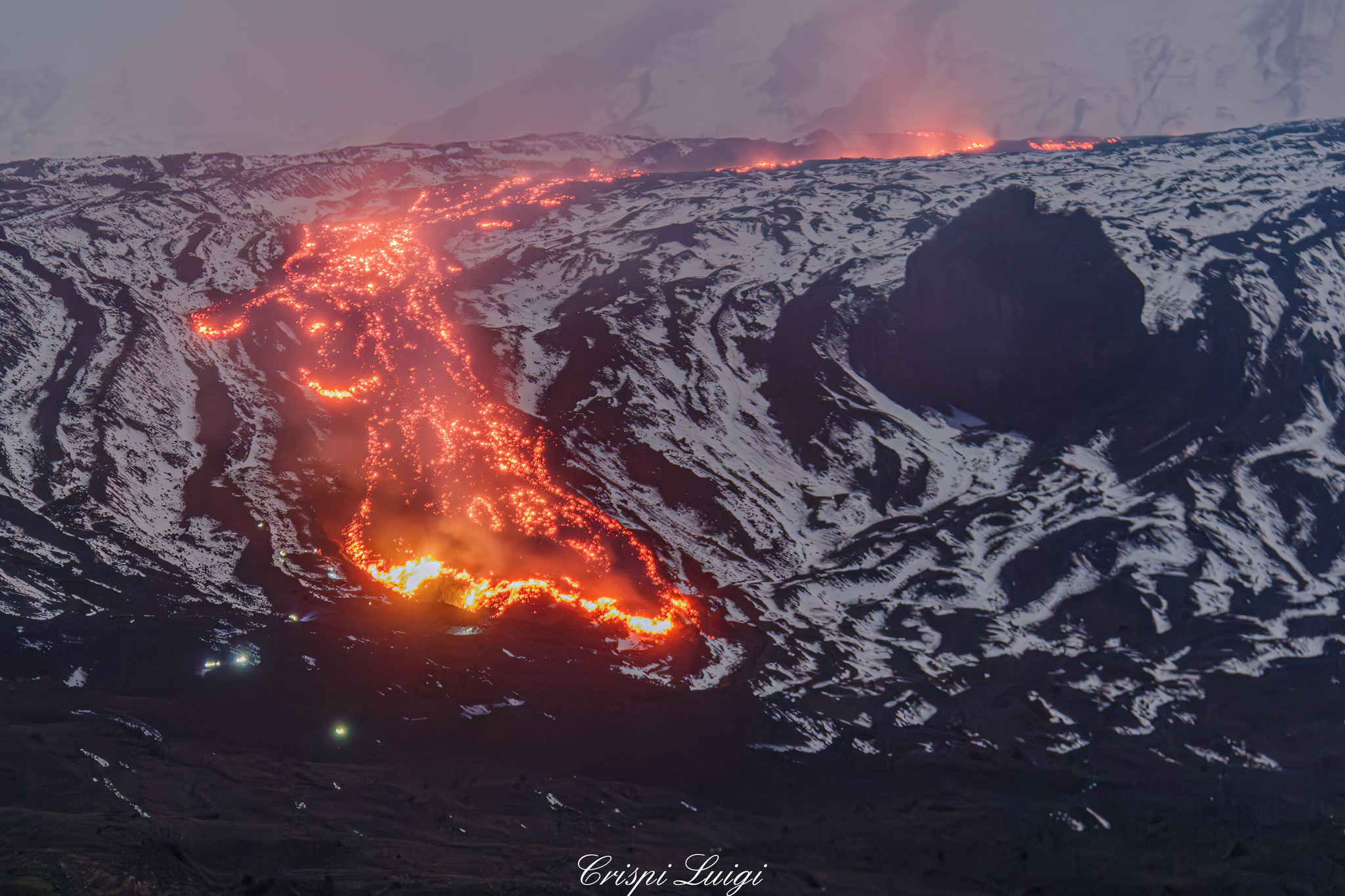
The National Institute of Geophysics and Volcanology (INGV), Etna Observatory, reports that starting at approximately 4:30 PM UTC, monitoring cameras observed effusive activity
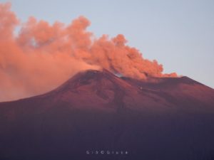
inside the Valle del Bove, near the northwest face. Measurements are currently being taken by INGV personnel. Explosive activity continues in the Bocca Nuova crater, with small ash emissions that are rapidly dispersing in the summit area.
From a seismic perspective, the average amplitude of the volcanic tremor is currently within the normal range. The location of the center of gravity of the volcanic tremor sources is currently unavailable due to technical limitations. The latest available position, at 14:15 UTC on December 31, 2025, indicated that the centroid remained in an area slightly northwest of the Northeast Crater, at an altitude of approximately 2,800 to 3,000 m above sea level. Infrasound activity is currently low, both in terms of frequency and energy of events, which are primarily located near the Voragine Crater.
Available tiltmeter and GNSS stations show no significant variation.
Etna Activity Report, January 1, 2026, 8:31 PM (7:31 PM UTC).
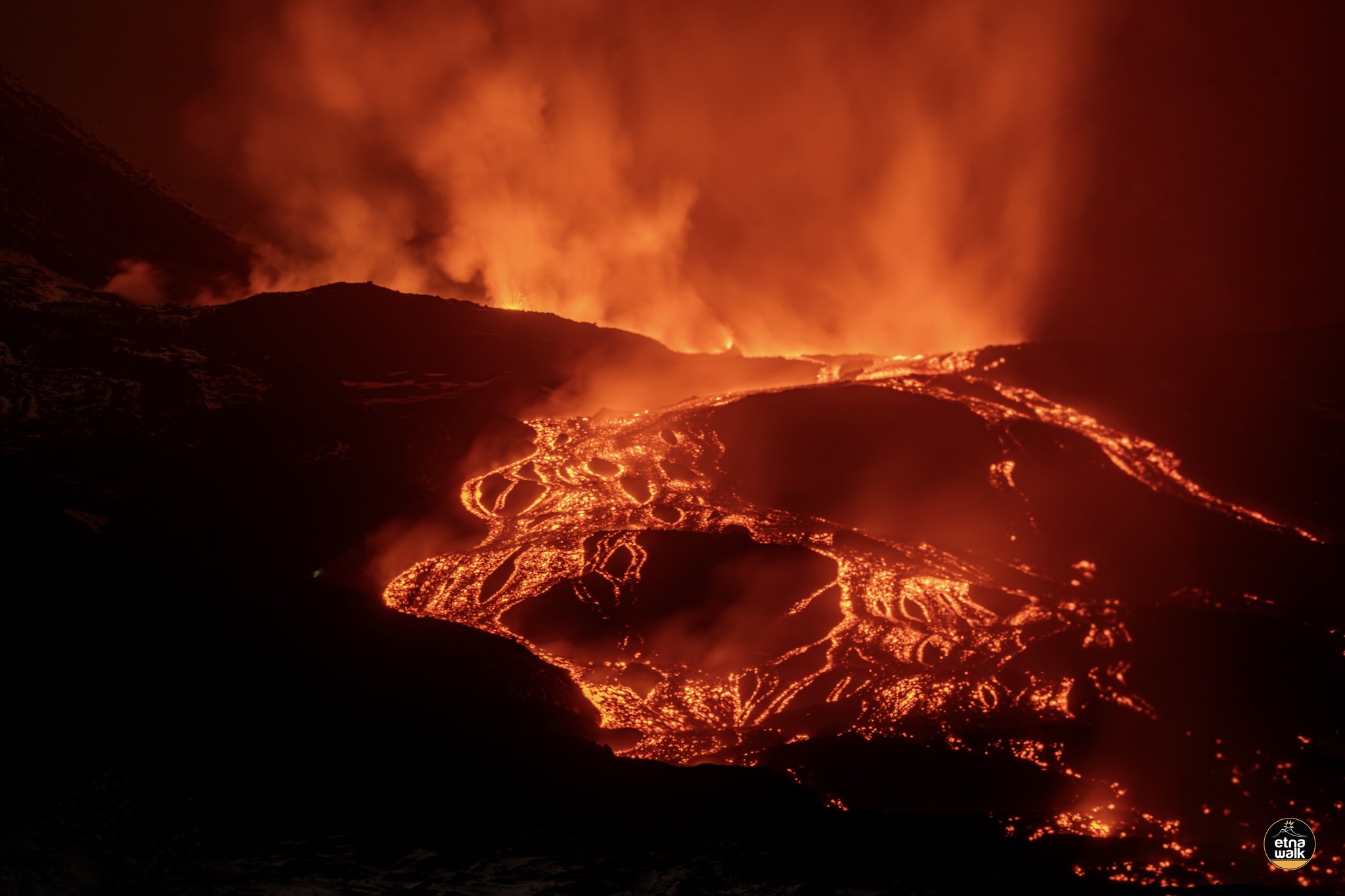
The National Institute of Geophysics and Volcanology (INGV), Etna Observatory, announces that, according to reports from its field staff and satellite imagery, the effusive vent feeding the activity in the Valle del Bove (see the Volcanic Activity Report of January 1, 2026, at 6:18 PM UTC) is located near Mount Simone, at an estimated altitude of approximately 2,100 m. Currently, the most advanced front is located immediately south of Rocca Musarra (approximately 1,580 m). Inspections are still underway by INGV staff.
Regarding seismic and infrasonic activity, no significant changes have been observed compared to the previous report. The GNSS and tilt networks show no substantial changes. A slight decompression trend is visible on the signals from the Monte Ruvolo extensometer (DRUV).
Etna Activity Update, January 2, 2026, 12:32 PM (11:32 UTC).
The National Institute of Geophysics and Volcanology (INGV), Etna Observatory, reports that surveillance cameras, satellite imagery, and field surveys conducted by INGV personnel show that the Valle del Bove lava field is still being fed and that the most advanced front has reached an altitude of approximately 1,420 meters above sea level, east of the Rocca Musarra peak. Currently, the maximum extent of the lava field is about 2.8 km.
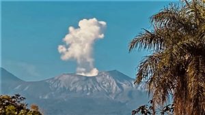
Furthermore, surveillance camera images taken early this morning showed weak Strombolian activity in the Voragine crater, with slight ash emissions that quickly dispersed in the summit area. Currently, due to adverse weather conditions, the summit area is invisible. From a seismic perspective, the average amplitude of the volcanic tremor remains within normal limits. The center of gravity of the volcanic tremor sources is located in an area near the Voragine crater, at an altitude of approximately 2,800 to 3,000 meters above sea level. Infrasound activity is currently low, both in terms of frequency and event energy. It appears to be concentrated primarily near the Voragine crater.
Ground deformation monitoring networks show no significant changes.
Further information will be released soon.
Source : INGV.
Photos : Etna Walk / Giuseppe Distefano / Marco Restivo , Luigi Crispi .
Indonesia , Semeru :
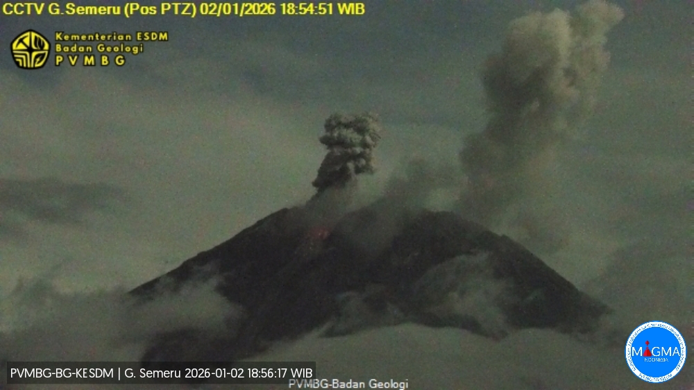
Mount Semeru erupted on Friday, January 2, 2026, at 6:54 PM (Jakarta time). An ash column was observed approximately 900 meters above the summit (at an altitude of about 4,576 meters). This column, white to gray in color and of moderate intensity, was drifting northward. At the time of writing, the eruption was still ongoing.
VOLCANO OBSERVATORY NOTICE FOR AVIATION – VONA
Issued : January 02 , 2026
Volcano : Semeru (263300)
Current Aviation Colour Code : ORANGE
Previous Aviation Colour Code : orange
Source : Semeru Volcano Observatory
Notice Number : 2026SMR013
Volcano Location : S 08 deg 06 min 29 sec E 112 deg 55 min 12 sec
Area : East java, Indonesia
Summit Elevation : 11763 FT (3676 M)
Volcanic Activity Summary :
Eruption with volcanic ash cloud at 11h54 UTC (18h54 local).
Volcanic Cloud Height :
Best estimate of ash-cloud top is around 14643 FT (4576 M) above sea level or 2880 FT (900 M) above summit. May be higher than what can be observed clearly. Source of height data: ground observer.
Other Volcanic Cloud Information :
Ash cloud moving to north. Volcanic ash is observed to be white to gray. The intensity of volcanic ash is observed to be medium.
Remarks :
Eruption recorded on seismogram with maximum amplitude 22 mm and maximum duration 110 second.
Source et photo : PVMBG
Colombia , Puracé – Los Coconucos volcanic chain:
Popayán, January 2, 2026, 9:30 a.m.
Regarding the monitoring of activity in the Los Coconucos volcanic chain, the Colombian Geological Survey (SGC), an agency under the Ministry of Mines and Energy, reports the following:
Since the publication of yesterday’s extraordinary bulletin, and continuing to this day, seismic activity related to fluid movements within the volcanic edifice continues. This activity consists of long-period (LP) earthquakes and tremors (TR). This seismicity, located beneath the Puracé volcano crater at a depth of less than 1.5 km, is linked to the internal dynamics of gases and their release into the atmosphere. Among these seismic signals, seven (7) were associated with ash emissions, for which alerts were issued to the Civil Aviation Authority. The columns dispersed according to the wind direction and reached up to 600 m in height above the summit of the volcano.

Significant emissions of sulfur dioxide (SO₂) into the atmosphere continue to be detected, and temperatures similar to those observed in previous days are still being recorded in the crater area, likely linked to the emission of hot gases from within the volcano. Furthermore, constant degassing continues through the fissure inside the Curiquinga volcano crater, without any ash emissions.
As long as the orange alert level remains in effect, temporary fluctuations in volcanic activity are possible; in other words, activity may sometimes decrease compared to previous days or weeks.
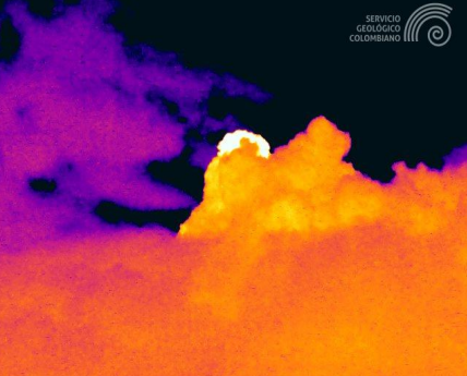
Image from the Mina infrared camera, located 2.2 km north of the Puracé volcano, showing a gas emission recorded on January 2 at 1:16 a.m. (local time).
Geological Service of Colombia (SGC) recommends staying away from the Puracé volcano crater and its surroundings, closely monitoring the situation through special bulletins and information published on our official channels, and following the instructions of local and departmental authorities and the National Unit for Disaster Risk Management (UNGRD).
The volcanic activity level remains at orange alert: Volcano exhibiting significant variations in monitored parameters.
Source et photo : SGC.
Japan , Satsuma Iwo-jima :
The Japan Meteorological Agency (JMA) reported that an eruption at Iodake Crater located at Satsuma Iwo-jima, a subaerial part of Kikai’s NW caldera rim, was recorded at 0207 on 29 December, the first since 3 September 2024. An eruption plume rose 200 m above the crater rim and drifted SW. The report noted that there were few volcanic earthquakes, and no notable changes detected before or after the eruption. No volcanic tremors were recorded. The Alert Level remained at 2 (on a 5-level scale), and residents were warned to be cautious within 500 m away from Iodake Crater.
![]()
Multiple eruption centers have exhibited recent activity at Kikai, a mostly submerged, 19-km-wide caldera near the northern end of the Ryukyu Islands south of Kyushu. It was the source of one of the world’s largest Holocene eruptions about 6,300 years ago when rhyolitic pyroclastic flows traveled across the sea for a total distance of 100 km to southern Kyushu, and ashfall reached the northern Japanese island of Hokkaido. The eruption devastated southern and central Kyushu, which remained uninhabited for several centuries. Post-caldera eruptions formed Iodake (or Iwo-dake) lava dome and Inamuradake scoria cone, as well as submarine lava domes. Recorded eruptions have occurred at or near Satsuma-Iojima (also known as Tokara-Iojima), a small 3 x 6 km island forming part of the NW caldera rim. Showa-Iojima lava dome (also known as Iojima-Shinto), a small island 2 km E of Satsuma-Iojima, was formed during submarine eruptions in 1934 and 1935. Mild-to-moderate explosive eruptions have occurred during the past few decades from Iodake, a rhyolitic lava dome at the eastern end of Satsuma-Iojima.
Sources : Japan Meteorological Agency (JMA) , GVP.
Photo : Ray_go
Peru , Sabancaya :
Local date and time: December 29, 2025 – 1:23 PM, Bulletin analysis period: December 22-28, 2025
Volcanic alert level
Orange alert level: The volcano’s eruptive activity has increased significantly. Increased seismic activity, frequent explosions, and emissions of ash and ballistic fragments have been observed.
Conclusions
The IGP reports that the Sabancaya volcano continues its eruptive process. During this period, three moderate volcanic explosions were detected, generating columns of ash and gas up to 3,500 meters above the volcano’s summit, in addition to seismic activity associated with the movement of magmatic fluids and internal fracturing. Therefore, the volcanic alert level remains orange.
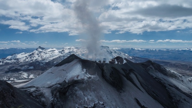
The Instituto Geofísico del Perú’s (IGP) Centro Vulcanológico Nacional (CENVUL) reported continuing eruptive activity at Sabancaya during 22-29 December. The seismic network detected 5-21 daily earthquakes indicating the movement of magma and gases. There were 0-4 daily thermal anomalies at the bottom of the crater identified in satellite images. Explosions at 15h24 and at 18h05 on 24 December produced eruption plumes that rose as high has 3.5 km above the crater rim. Gas, steam, and ash plumes rose as high as 1 km above the crater rim and drifted in various directions within 10 km on most days during 25-29 December. The Alert Level remained at Orange (the third level on a four-color scale) and the public was warned to stay outside of a 12 km radius from the summit.
Sources : Cenvul , GVP.
Photo : IGP.