November 15 , 2025.
Hawaii , Kilauea :
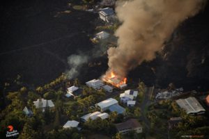
The federal government has reopened following the longest shutdown in United States history, and the USGS Hawaiian Volcano Observatory is once again posting photos to its website, including some featuring the high lava fountain episodes that occurred during the closure.
The federal government shutdown began on October 1, 2025, and lasted for 43 days. During that time, the USGS HVO continued to monitor Kīlauea volcano, and document the eruptive episodes that were occurring at the summit within Hawaiʻi Volcanoes National Park. Although USGS webcams continued to stream live video from the summit, and daily updates were provided, the Observatory was unable to share photos taken by scientists on the official website.
HAWAIIAN VOLCANO OBSERVATORY DAILY UPDATE U.S. Geological Survey
Friday, November 14, 2025, 9:43 AM HST (Friday, November 14, 2025, 19:43 UTC)
19°25’16 » N 155°17’13 » W,
Summit Elevation 4091 ft (1247 m)
Current Volcano Alert Level: WATCH
Current Aviation Color Code: ORANGE

On October 21, a USGS Hawaiian Volcano Observatory field engineer dug out monitoring equipment buried by tephra fallout from the episode 35 lava fountaining.
Activity Summary:
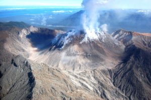
The Kīlauea summit eruption is paused. Overnight, the south vent showed persistent glow, while intermittent glow was visible from the north vent. Weak incandescent spots could also be seen on the slopes around the vents. Preliminary results for the forecast window suggest that episode 37 could occur between November 21 to November 28.
Summit Observations:
Glow was observed from both vents overnight. The glow varied from weak to strong, with the south vent glow generally stronger. Only a few spots of incandescence were visible around the vents and the small rockfalls on the crater wall that exposed incandescent material appear to have stopped.
The UWD tiltmeter has recorded about 11 microradians of inflationary tilt since the end of episode 37. Tremor spikes continue every 5–10 minutes and appear to be related to gas pistoning deeper in the vents.
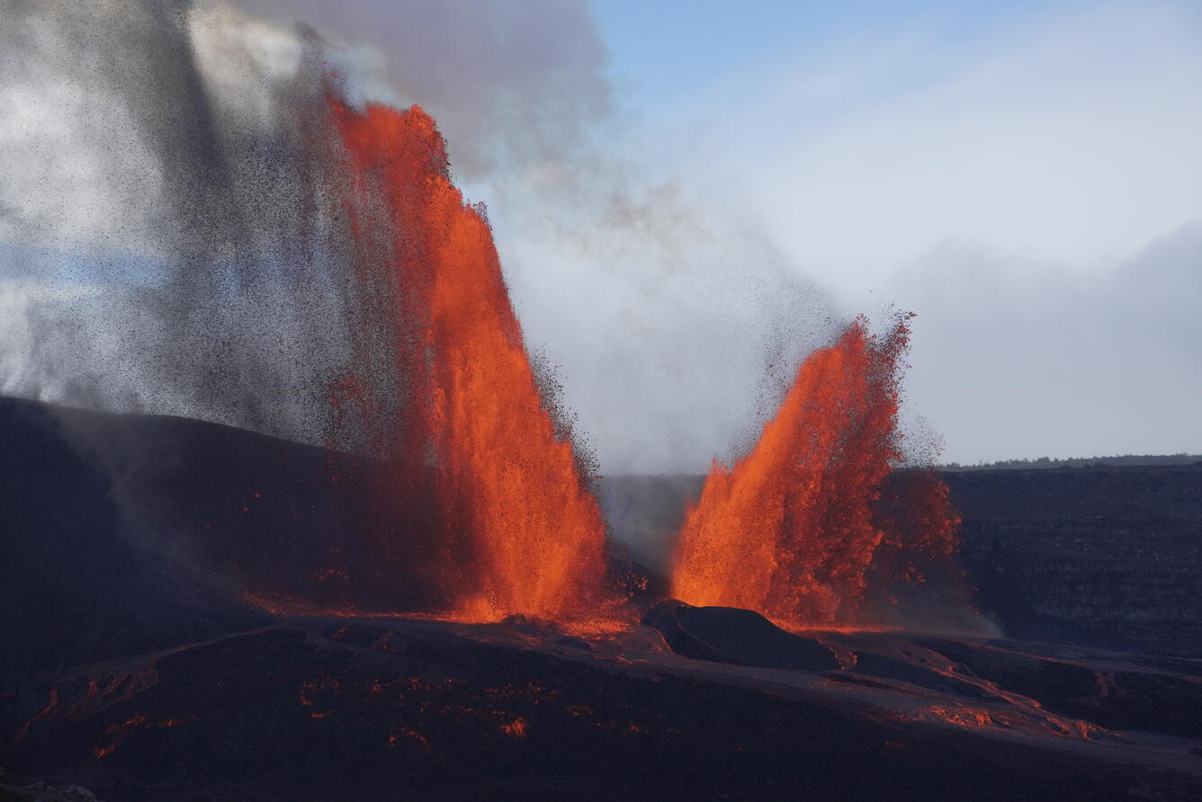
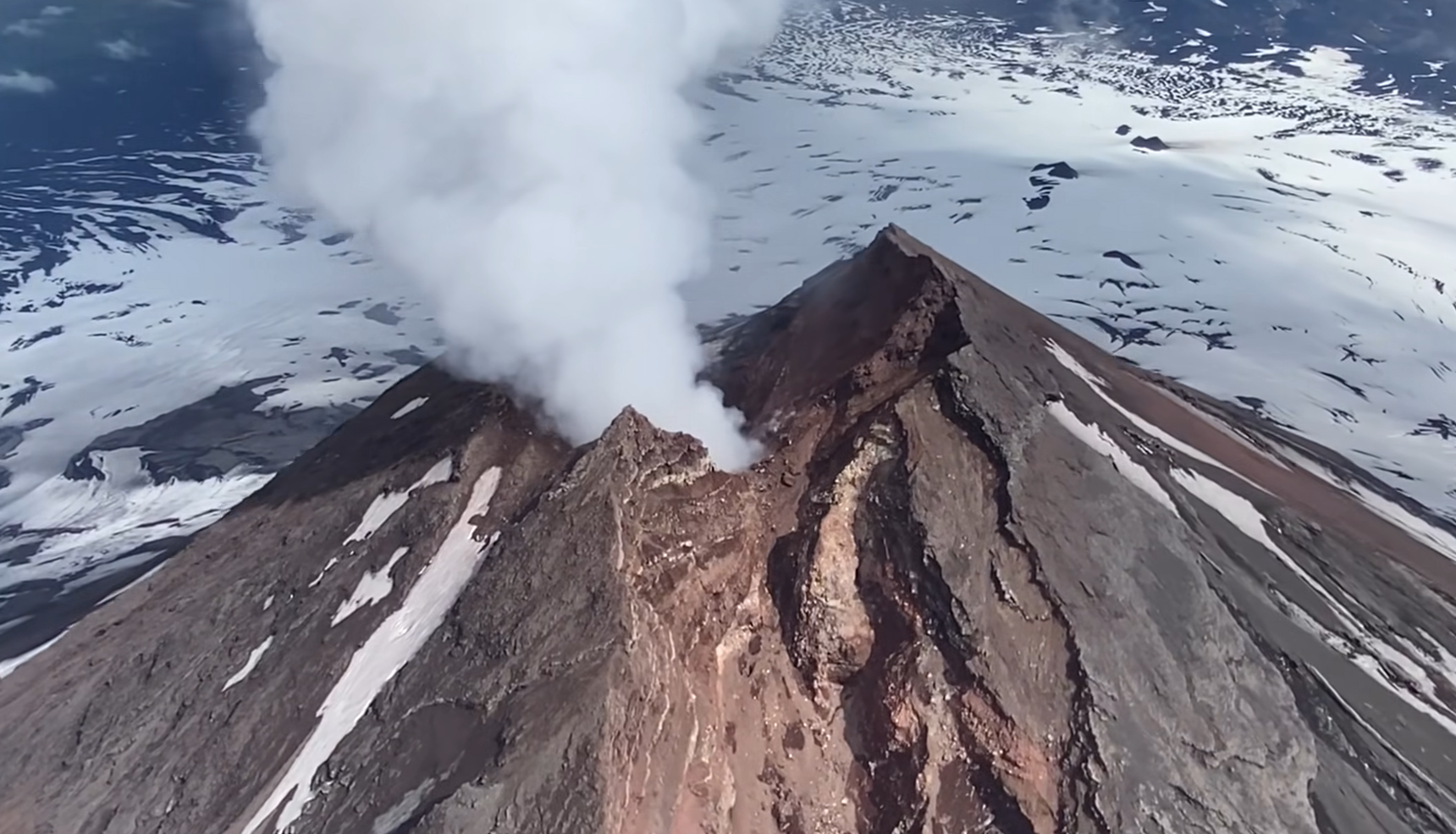
View of the dual fountains during episode 36 at the summit of Kīlauea, on Sunday, November 9. View is from the south rim of Halema‘uma‘u crater. Peak heights of lava fountains erupted during this episode reached about 350 meters (1150 feet).
Plumes of gas from both the south and north vents are visible this morning and sulfur dioxide (SO2) gas emissions remain at eruption pause levels, typically between 1,200 and 1,500 tonnes per day.
Episode 36 began at approximately 11:15 a.m. HST on November 9 and ended at 4:16 p.m. HST, after erupting for 5 hours. The north vent stopped earlier, at 3:38 p.m. HST, and the south vent gradually decreased in height and volume until it stopped erupting at 4:16 p.m. HST. South vent fountains reached heights of about 1,200 feet (360 meters) and north vent fountains reached heights of about 750 feet (230 meters). Episode 36 fountains produced just under 11 million cubic yards (about 8 million cubic meters) of lava. The combined average eruption rate was over 600 cubic yards per second (500 cubic meters per second) from the dual fountains. Lava flows from the fountains covered about 80 percent of the floor of Halemaʻumaʻu crater.
Sources : Big island Video news , HVO.
Photos : M. Patrick .
Chile , Planchón Peteroa :
Special Volcanic Activity Report (REAV), Maule Region, Planchón Peteroa Volcanic Complex
November 13, 2025, 10:10 a.m. local time (Mainland Chile)
The Chilean National Geological and Mining Service (Sernageomin) publishes the following PRELIMINARY information, obtained through monitoring equipment of the National Volcanic Monitoring Network (RNVV), processed and analyzed at the Southern Andes Volcanological Observatory (OVDAS):
On Thursday, November 13, images from monitoring cameras installed near the Planchón Peteroa Volcanic Complex revealed a column of gas and pyroclastic material observed at 1:00 p.m. UTC, reaching a height of 1,860 meters above the crater (Figure 1), and dispersing in a northeast direction.
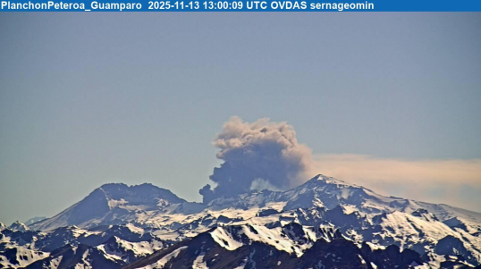
Image from the Guamparo surveillance camera, dated November 13, 2025, at 10:00 a.m. local time (1:00 p.m. UTC).
Based on the latest volcanic activity reports published by SERNAGEOMIN for this system, and considering the above, the possibility of further episodes of similar or greater energy, low to medium magnitude, affecting the immediate vicinity of the active craters, cannot be ruled out.
OBSERVATIONS: As of the date of publication of this report, the aforementioned pyroclastic flow continues, while seismic activity shows no other significant changes.
The volcanic alert level remains: Yellow Technical Alert.
Source et photo : Sernageomin
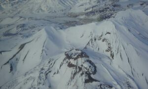
Alaska , Shishaldin :
Signs of volcanic unrest at Shishaldin continued this week. Low-level seismicity is ongoing, with frequent small earthquakes occurring daily. Infrasound signals were detected on most days when wind noise did not obscure them. The infrasound signals are likely caused by gas bubbles bursting through magma deep within the conduit. Satellite data show no evidence of elevated temperatures in the summit crater, indicating no lava at or near the surface.
Satellite observations of SO2 over the past week had a high noise level, but suggest continued SO2 emissions. Most clear web camera views of the volcano over the past week showed steam emissions at the summit.
Shishaldin Volcano is monitored by local seismic and infrasound sensors, web cameras, and a telemetered geodetic network. In addition to the local monitoring network, AVO uses nearby geophysical networks, regional infrasound and lighting data, and satellite images to monitor the volcano.
Source : AVO.
Photo : AVO , Capture d’écran 26/08/2025 .
Indonesia , Ili Lewotolok :
An eruption of Mount Ili Lewotolok occurred on Wednesday, November 12, 2025, at 5:27 PM (West African local time). The observed ash column rose approximately 300 meters above the summit (at an altitude of about 1,723 meters). This intense, gray ash column drifted westward. The eruption was recorded by a seismograph, with a maximum amplitude of 6.6 mm and a duration of 40 seconds.

Seismic Observations
15 eruption earthquakes with amplitudes ranging from 4 to 22.4 mm and durations from 27 to 54 seconds.
157 emissions earthquakes with amplitudes ranging from 1.1 to 7.1 mm and durations from 20 to 45 seconds.
1 harmonic tremor with an amplitude of 1.3 mm and a duration of 134 seconds.
1 deep volcanic earthquake with an amplitude of 4.7 mm and a duration of 9 seconds.
1 local tectonic earthquake with an amplitude of 6.2 mm and a duration of 27 seconds.
3 distant tectonic earthquakes with amplitudes ranging from 1.2 to 6.8 mm and durations from 54 to 65 seconds.
Recommendations
1. Residents living around Mount Ili Lewotolok, as well as visitors, climbers, and tourists, are advised to refrain from any activity or access within a 2 km radius of the Mount Ili Lewotolok activity center and within a 2.5 km radius of the South-Southeast and West sectors.
2. Be vigilant for the risk of lava avalanches and pyroclastic flows in the South, Southeast, West, and Northeast sectors of Mount Ili Lewotolok. The public is advised not to panic if rumbling or detonating sounds are heard from the Mount Ili Lewotolok crater, as these noises are characteristic of volcanic activity during an eruptive phase.
Source et photo : Magma Indonésie.
Colombia , Galeras :
Following the monitoring of activity at the Galeras volcano, the Colombian Geological Survey (SGC), an agency under the Ministry of Mines and Energy, reports the following:
During the week of November 4-10, 2025, the main variations in monitored parameters compared to the previous week were as follows:
● Seismic activity and energy released decreased slightly, remaining at low levels. Seismicity associated with rock fracturing was predominant.
● Earthquakes were mainly located near the crater of the Galeras volcano, with low energy and shallow depths, less than 2 km (reference level: 4,200 m). A few other earthquakes were recorded in different sectors of the volcanic edifice, at distances of up to 6 km and depths between 6 and 9 km. The maximum magnitude for this type of earthquake was 1.1.
● Small plumes of white gas, located at low altitude, were observed, emanating mainly from the fumarole fields of El Paisita (to the north) and Las Chavas (to the west). The dispersion of these plumes varied depending on the wind direction and strength.
● All other volcanic monitoring parameters remained stable.
Given the above, the Geological Survey of Colombia (SGC) recommends closely monitoring their evolution through weekly bulletins and other information published by its official channels, as well as following the instructions of local and departmental authorities and the National Unit for Disaster Risk Management (UNGRD).
Volcanic activity remains at the yellow alert level: Active volcano with changes in the basic behavior of monitored parameters and other manifestations.
Source et photo : SGC