November 2 , 2025.
Hawaii , Kilauea :
HAWAIIAN VOLCANO OBSERVATORY DAILY UPDATE , U.S. Geological Survey
Saturday, November 1, 2025, 8:44 AM HST (Saturday, November 1, 2025, 18:44 UTC)
19°25’16 » N 155°17’13 » W,
Summit Elevation 4091 ft (1247 m)
Current Volcano Alert Level: WATCH
Current Aviation Color Code: ORANGE
During the lapse in appropriations, the USGS Hawaiian Volcano Observatory (HVO) continues to maintain monitoring networks and issue updates and notifications of volcanic activity via the Hazard Notification Service. Volcano monitoring data will continue to be available on the HVO website. Static website content will not be updated until further notice and information may become outdated over time.
Activity Summary:
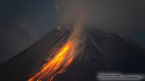
Episode 35 of the ongoing Halemaʻumaʻu eruption ended on October 18 after 7.5 hours of continuous lava fountaining. Both vents continue to exhibit incandescence and there was one short overflow from the north vent overnight. Kīlauea summit inflation continues along with seismic tremor and vent glow indicating that another lava fountaining episode is probable. Models suggest a likely forecast window of November 4–8 for episode 36 with November 5-7 most probable.
Sumit Observations:
The north vent had moderate to strong glow overnight with one gas piston overflow from 9:25-9:28 p.m. on October 31. The south vent had weak to moderate intermittent glow. (Note: All of the cameras were zoomed in on the vents last night and the infrared filters were turned off on the V2 and V3 making them appear much brighter and white in color.)
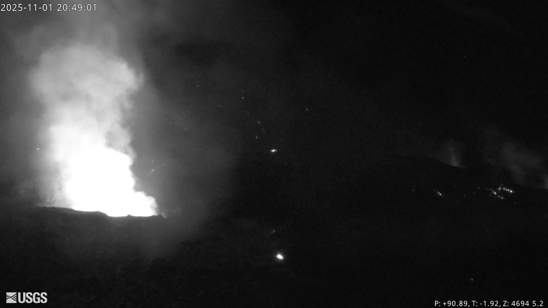
The summit continues to inflate. The Uēkahuna tiltmeter (UWD) has recorded just under 1 microradian of inflationary tilt over the past 24 hours and 22.3 microradians of inflationary tilt since the end of episode 35. Tremor patterns consisted of continuous tremor yesterday until about 5:30 p.m. when moderate spikes signaled the return of gas pistoning activity, which lasted until the short overflow event. A sharp spike in tremor accompanied drainback from this event and tremor became more constant for the rest of the night and early morning.
Plumes of gas continue from both vents this morning and sulfur dioxide (SO2) gas emissions remain at background levels, typically between 1,200 and 1,500 tonnes per day.
Source : HVO.
Indonesia , Marapi :
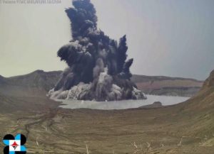
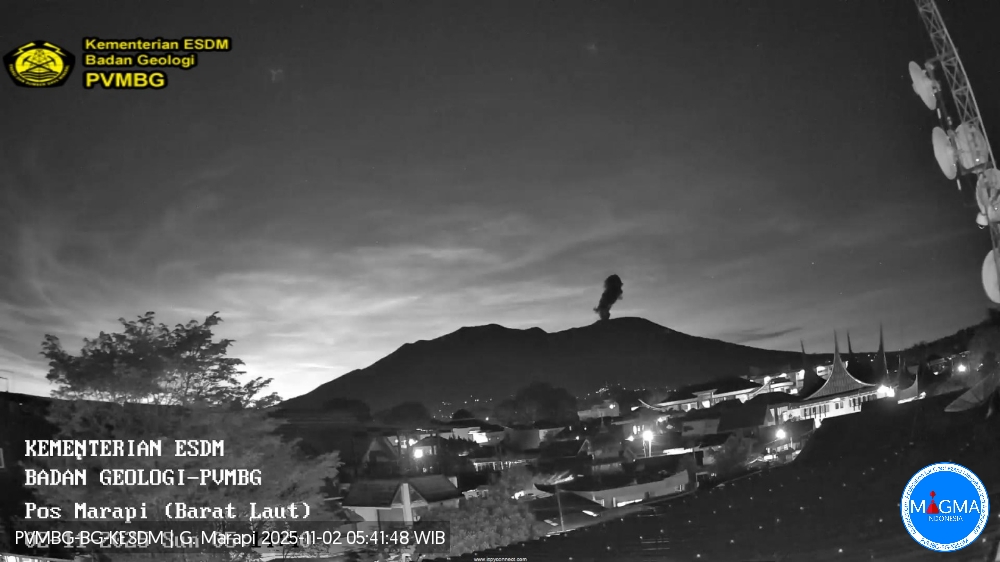
Mount Marapi erupted on Sunday, November 2, 2025, at 5:11 AM WIB. An ash column was observed approximately 300 meters above the summit (at an altitude of about 3,191 meters). This ash column, white to gray in color, was highly intense and extended to the southeast. The eruption was recorded by a seismograph with a maximum amplitude of 3.8 mm and a duration of 22 seconds.
Seismicity Observations
1 emission earthquake with an amplitude of 5.7 mm and a duration of 30 seconds.
12 local tectonic earthquakes with amplitudes ranging from 1.3 to 30.3 mm and durations from 23 to 62 seconds.
4 distant tectonic earthquakes with amplitudes ranging from 1.7 to 23.8 mm and durations from 50 to 139 seconds.
Recommendations
1. Communities living near Mount Marapi, climbers, visitors, and tourists are advised to refrain from all activity within a 3 km radius of the activity center (Verbeek Crater) of Mount Marapi.
2. Communities living near valleys, banks or rivers originating at the summit of Mount Marapi are advised to remain vigilant against the potential danger of lahars or lahar floods, which may occur, especially during the rainy season.
Source et photo : Magma Indonésie .
Colombia , Cumbal :
San Juan de Pasto, October 28, 2025, 5:10 PM
Regarding the monitoring of activity at the Cumbal Volcanic Complex (CVC), the Colombian Geological Service (SGC), an agency under the Ministry of Mines and Energy, reports the following:
During the week of October 21-27, 2025, the main variations in monitored parameters compared to the previous week were as follows:
• Seismic activity decreased slightly; however, the seismic energy released increased. Events associated with rock fracturing remain predominant.
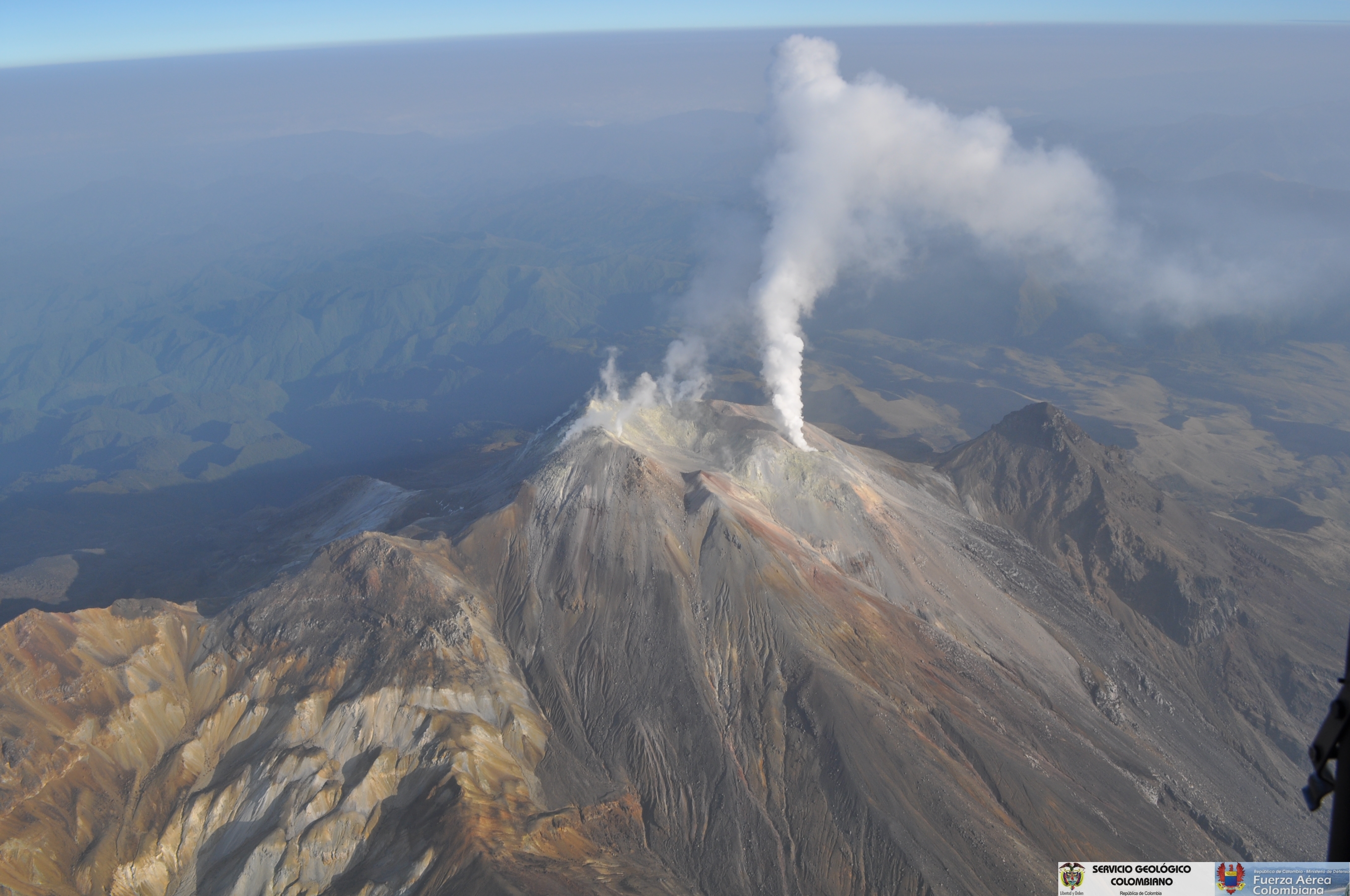
• Most seismic events occurred near the complex, within a 2.5 km radius and up to 6 km deep from the La Plazuela crater (4,700 m altitude). The strongest earthquake (magnitude 1.2) was recorded 2 km south-southwest of the La Plazuela crater, at a depth of 4.5 km.
Gas emissions were observed from the El Verde fumarole field.
Other monitored parameters (such as ground deformation) did not show significant variations and remained stable.
In light of the above, the Geological Survey of Colombia (SGC) recommends closely monitoring the situation through weekly bulletins and other information published by its official channels, as well as following the instructions of local and departmental authorities and the National Disaster Risk Management Unit (UNGRD).
Volcanic activity remains at the yellow alert level: active volcano showing changes in the reference behavior of monitored parameters and other manifestations.
Source et photo : SGC.
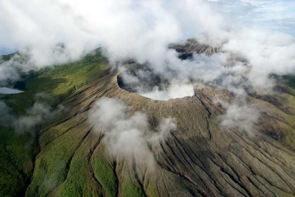
Costa Rica , Rincón de la Vieja :
Latitude: 10.83°N;
Longitude: 85.34°W;
Altitude: 1916 m.
Current Activity Level: Alert.
Seven small eruptions were recorded this week. None resulted in a decrease in lahars. Background tremor varied in amplitude and frequency throughout the week.
Brief pulses of higher amplitude tremor were also observed between October 25 and 26, and between October 28 and 29. From October 29 onward, tremor decreased, which could indicate a partial closure of cavities or conduits responsible for the accumulation of volcanic gases and the occurrence of phreatic eruptions. A slight increase in the number of long-period signals was also observed this week, some exhibiting multiple harmonic codas. The occurrence of long-period, tornillo-type events continues. Geodetic observations show a narrowing of the base.
This week, DOAS stations recorded a decrease in SO₂ flux (78 ± 42 t/d) compared to the previous week (142 ± 125 t/d). The MultiGAS station continues to record low gas concentrations and variable gas ratios. The last satellite detection of atmospheric SO₂ was on September 7. The Santuarium hot spring, located in Sensoria, Land of Senses, about 4 km north of the Rincón crater, has seen an increase in flow rate following recent heavy rainfall. Santuarium recorded a temperature of 33.3 °C on October 29, 2025, a value similar to those recorded since 1989 (between 30 and 36 °C). Furthermore, the Blue River hot springs, about 7 km north of the Rincón crater, also show stable temperatures, comparable to those recorded in recent years. The temperature data for the Blue River springs recorded on October 29, 2025 were as follows: Paila de Burbujas 62.4 degrees Celsius and Neftalí 49.8 degrees Celsius.
Source et photo : Ovsicori.
Alaska , Great Sitkin :
ALASKA VOLCANO OBSERVATORY WEEKLY UPDATE , U.S. Geological Survey
Friday, October 31, 2025, 11:48 AM AKDT (Friday, October 31, 2025, 19:48 UTC)
52°4’35 » N 176°6’39 » W,
Summit Elevation 5709 ft (1740 m)
Current Volcano Alert Level: WATCH
Current Aviation Color Code: ORANGE
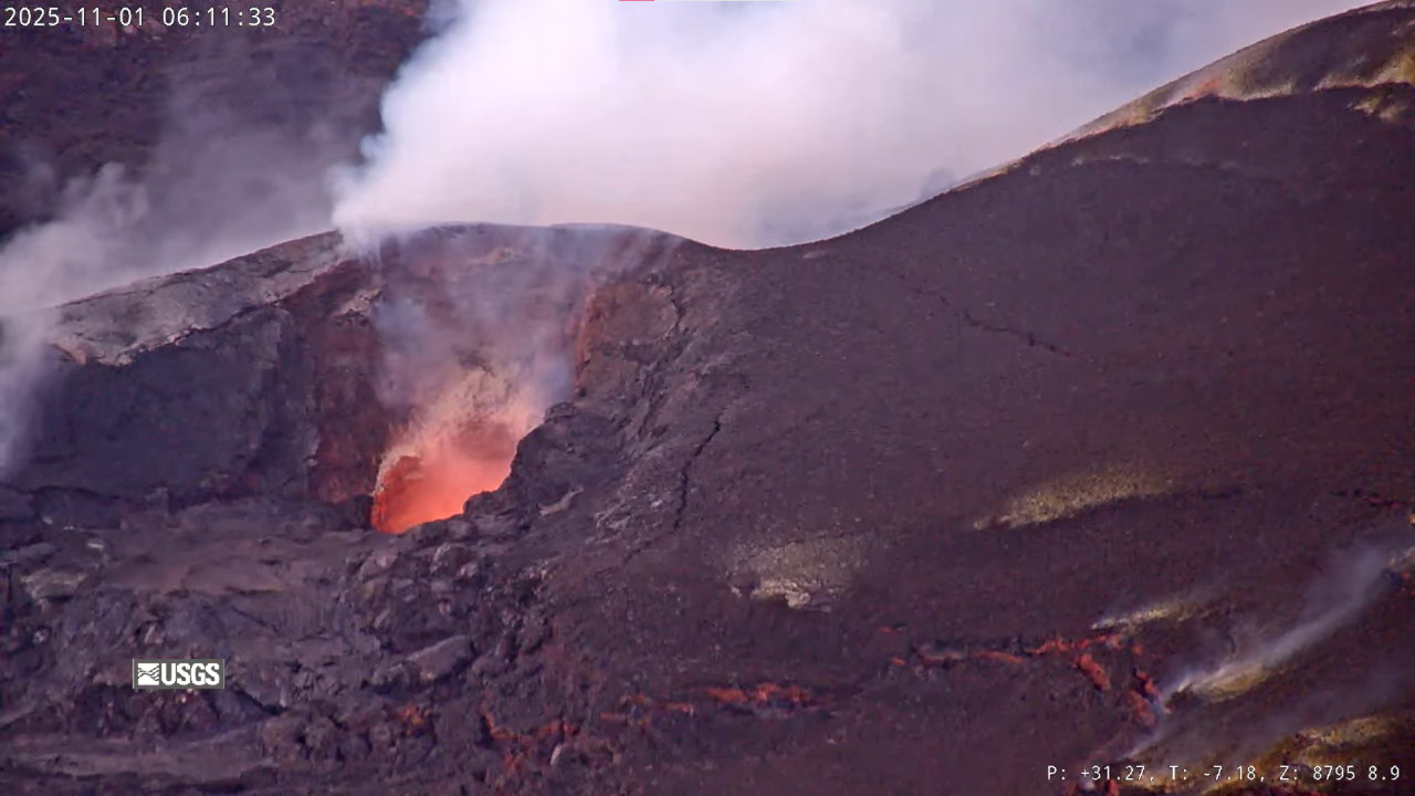
Lava continues to erupt within the summit crater at Great Sitkin Volcano. Satellite and webcam observations have been mostly blocked by clouds, but satellite observations from October 26 show continued growth of the lava dome generally toward the south. Seismicity has been low, and occasional small earthquakes and signals related to rockfall activity continue to be detected in seismic data.
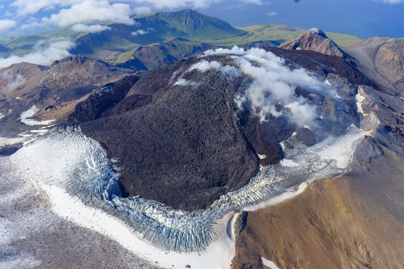
The current lava eruption began in July 2021 and has filled most of the summit crater and advanced into valleys below. There have been no explosions at Great Sitkin Volcano since an event in May 2021. The volcano is monitored using local seismic and infrasound sensors, satellite data and web cameras, and regional infrasound and lightning networks.
Great Sitkin Volcano is a basaltic andesite volcano that occupies most of the northern half of Great Sitkin Island, a member of the Andreanof Islands group in the central Aleutian Islands. It is located 26 miles (42 km) east of the community of Adak. The volcano is a composite structure consisting of an older dissected volcano and a younger parasitic cone with a ~1 mile (1.6 km)-diameter summit crater. A steep-sided lava dome, emplaced in the crater during an eruption in 1974, has been mostly buried by the ongoing eruption. The 1974 eruption produced at least one ash cloud that likely exceeded an altitude of 25,000 ft (7.6 km) above sea level. A poorly documented eruption also occurred in 1945, producing a lava dome that was partially destroyed in the 1974 eruption. Within the past 280 years a large explosive eruption produced pyroclastic flows that partially filled the Glacier Creek valley on the southwest flank.
Source : AVO.
Photo : Loewen, Matt / Alaska Volcano Observatory / U.S. Geological Survey.