October 26 , 2025.
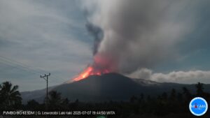
Philippines , Taal :
One minor phreatic (02:55 AM) and two minor phreatomagmatic (08:13 AM and 08:20 AM) eruptions at the Main Crater of Taal Volcano that occurred today, 26 October 2025. These events generated plumes that rose up to 1200 – 2100 meters above the crater as recorded by the Main Crater IP and thermal cameras.
Alert Level 1 prevails over Taal Volcano.
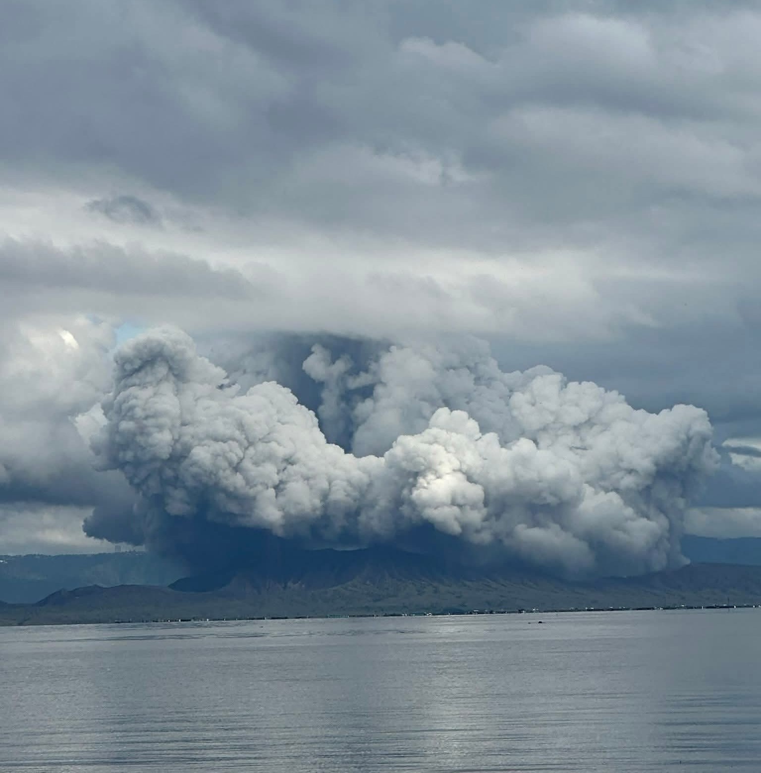
Taal is one of the most active volcanoes in the Philippines and has produced some powerful eruptions. The 15 x 20 km Talisay (Taal) caldera is largely filled by Lake Taal, whose 267 km2 surface lies only 3 m above sea level. The maximum depth of the lake is 160 m, with several submerged eruptive centers. The 5-km-wide Volcano Island in north-central Lake Taal is the location of all observed eruptions. The island is composed of coalescing small stratovolcanoes, tuff rings, and scoria cones. Powerful pyroclastic flows and surges have caused many fatalities.
Sources : Phivolcs , GVP.
Photo : via Philippine Weather System/Pacific Storm Updat
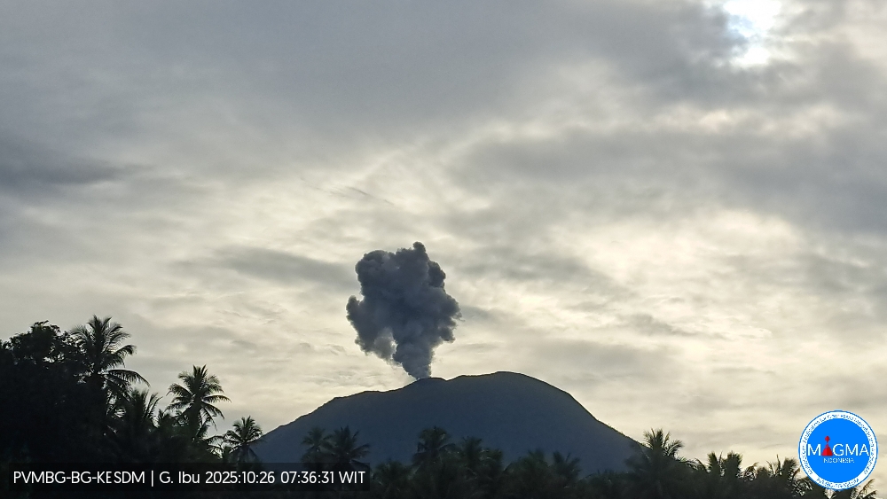
Indonesia , Ibu :
Mount Ibu erupted on Saturday, October 25, 2025, at 6:35 a.m. (local time). An ash column was observed about 900 m above the summit (about 2,225 m above sea level). The ash column was white to gray in color, with moderate to thick intensity, oriented toward the east and southeast. This eruption was recorded by seismograph with a maximum amplitude of 28 mm and a duration of 55 seconds.
Seismic Observations
91 eruptive earthquakes with amplitudes ranging from 15 to 28 mm and durations ranging from 32 to 81 seconds.
4 emission earthquakes with amplitudes ranging from 3 to 8 mm and durations ranging from 33 to 43 seconds.
20 harmonic tremors with amplitudes ranging from 2 to 10 mm and durations ranging from 20 to 160 seconds.
103 low-frequency earthquakes with amplitudes ranging from 2 to 10 mm and durations ranging from 17 to 29 seconds.
201 shallow volcanic earthquakes with amplitudes ranging from 2 to 8 mm and durations ranging from 7 to 21 seconds.
3 deep volcanic earthquakes with amplitudes ranging from 2 to 6 mm and durations ranging from 11 to 25 seconds.
48 distant tectonic earthquakes with amplitudes ranging from 2 to 28 mm and lasting from 33 to 122 seconds.
Recommendations
Residents of the vicinity of Mount Ibu and visitors/tourists are advised to avoid all activity within a 2 km radius and within a 3.5 km radius of the crater opening, in the northern part of the active crater of Mount Ibu.
In the event of ashfall, those engaging in outdoor activities are advised to wear a mask and protective eyewear.
Source et photo : Magma Indonésie .
Chile , Planchón Peteroa :
Special Volcanic Activity Report (REAV), Maule Region, Planchón Peteroa Volcanic Complex
October 25, 2025, 9:32 a.m. local time (Continental Chile)
The National Geology and Mining Service of Chile (Sernageomin) publishes the following preliminary information, obtained using the monitoring equipment of the National Volcanic Monitoring Network (RNVV), processed and analyzed at the Southern Andean Volcanological Observatory (OVDAS):
Today, Saturday, October 25, using images from surveillance cameras installed near the Planchón Peteroa Volcanic Complex, a column of gas and pyroclasts was observed at 11:32 UTC. It reached 1,100 meters above the crater (Figure 1), dispersing northward.
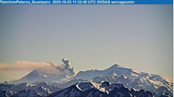
Image from the Guamparo surveillance camera, dated October 25, 2025, at 8:32 AM HL (11:32 UTC).
According to the latest volcanic activity reports published by SERNAGEOMIN for this system, and taking into account the above, the occurrence of new episodes of explosions of similar or greater energy, of low to moderate magnitude, likely to affect the immediate vicinity of active craters, cannot be ruled out.
OBSERVATIONS:
As of the publication date of this report, seismic activity has not shown any other significant changes.
The technical volcanic alert remains in effect at: YELLOW Technical Alert.
Source et photo : Sernageomin.
Colombia , Cumbal :
San Juan de Pasto, October 21, 2025, 4:50 p.m.
Regarding the monitoring of the activity of the Cumbal Volcanic Complex (CVC), the Colombian Geological Survey (SGC), an entity attached to the Ministry of Mines and Energy, reports that:
During the week of October 14 to 20, 2025, the main variations in the monitored parameters compared to the previous week were:
● An increase in the frequency of earthquakes and their energy release was recorded.
● The most significant contribution was seismic activity associated with rock fracturing processes.
● Most of the earthquakes were located near the La Plazuela crater, forming a southwest-northeast alignment with respect to the volcanic complex, at a maximum distance of 3.1 km. These events had a maximum magnitude of 0.7 and a depth of up to 6.3 km, according to the La Plazuela crater (4,700 m altitude).
● Gas emissions were recorded in the El Verde fumarole field, located to the northeast, and in the Boca Vieja and Rastrojos fumarole fields, located to the southeast of the CVC, with dispersion predominantly toward the northeast due to wind action.
● Other volcanic monitoring parameters remained stable.
In view of the above, the SGC recommends closely monitoring their developments through weekly bulletins and other information published through our official channels, as well as instructions from local and departmental authorities and the National Disaster Risk Management Unit (UNGRD).
Volcanic activity remains on alert: Yellow: Active volcano with changes in the baseline behavior of monitored parameters and other manifestations.
Source et photo : SGC
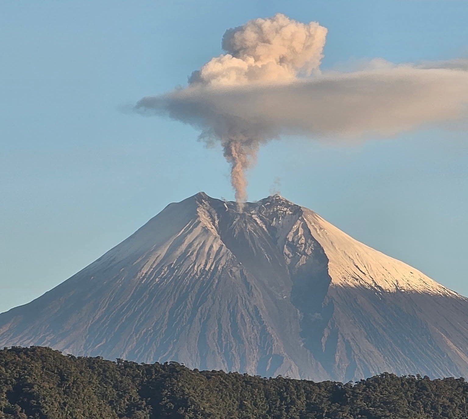
Ecuador , Sangay :
DAILY STATUS REPORT OF SANGAY VOLCANO, Saturday, October 25, 2025.
Information Geophysical Institute – EPN.
Surface Activity Level: Moderate, Surface Trend: No Change
Internal Activity Level: Moderate, Internal Trend: No Change
Seismicity: From October 24, 2025, 11:00 a.m. to October 25, 2025, 11:00 a.m.:
Seismicity:
Below is the count of seismic events recorded at the reference station.
Explosion (EXP): 106
Rainfall/Lahars:
No rainfall was recorded in the volcanic area. **Heavy rainfall could remobilize accumulated material, generating mud and debris flows that would cascade down the volcano’s flanks and flow into adjacent rivers.**
Emissions/Ash Plume:
Due to cloud cover in the volcanic area, only two gas and ash emissions were observed by surveillance cameras, at 500 and 1,000 meters above the crater, in northwest and west-southwest directions. Meanwhile, the Washington-based VAAC agency issued three reports of ash plumes moving west and northwest, at 600 and 1,500 meters above the crater.
Gas:
The MOUNTS satellite system reported 24.40 tons of sulfur dioxide (SO2) today, measured yesterday at 1:36 PM LT.
Other monitoring parameters:
The MIROVA-MODIS satellite system recorded two thermal anomalies, the MIROVA-VIIRS system five thermal anomalies, and the FIRMS satellite system six thermal anomalies over the past 24 hours.
Observation:
Last night, the surveillance camera system observed several episodes of incandescence and a descent of material on the northwest flank of the volcano, up to 1,200 meters below the crater level. As of the closing date of this report, the volcano remains completely cloudy.
Alert level: Yellow
Source : IGEPN
Photo : Missael Rivadeneira / Volcan Sangay / FB.