October 20 , 2025.
Kamchatka , Krasheninnikov :
VOLCANO OBSERVATORY NOTICE FOR AVIATION (VONA)
Issued: October 20 , 2025
Volcano: Krasheninnikov (CAVW #300190)
Current aviation colour code: ORANGE
Previous aviation colour code: orange
Source: KVERT
Notice Number: 2025-117
Volcano Location: N 54 deg 35 min E 160 deg 16 min
Area: Kamchatka, Russia
Summit Elevation: 1856 m (6087.68 ft)
Volcanic Activity Summary:
Moderate explosive activity of the volcano continues. The explosions sent ash up to 3 km a.s.l., and ash cloud is extending about 47 km to the east of the volcano.
The activity of the volcano continues. The danger of ash explosions up to 8 km (26,200 ft) a.s.l. remains. Ongoing activity could affect low-flying aircraft.
Volcanic cloud height:
2500-3000 m (8200-9840 ft) AMSL Time and method of ash plume/cloud height determination: 20251020/0341Z – MODIS AQUA 31m32
Other volcanic cloud information:
Distance of ash plume/cloud of the volcano: 47 km (29 mi)
Direction of drift of ash plume/cloud of the volcano: E / azimuth 92 deg
Time and method of ash plume/cloud determination: 20251020/0341Z – MODIS AQUA 31m32
Remarks:
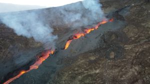
The first historical eruption of the volcano began on 02 August, 2025. The explosive-effusive eruption of the volcano continues. The previous effusive eruption of the volcano occurred 400-600 years ago. In 1963, fumarole activity was noted in the crater of the middle Northern cone.
Source : Kvert
Photo : Westernpacificweather.com (archive)
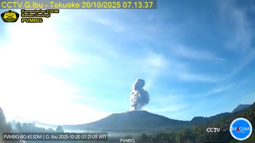
Indonesia , Ibu :
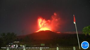
Mount Ibu erupted on Monday, October 20, 2025, at 7:10 a.m. (local time). An ash column was observed about 1,200 m above the summit (about 2,525 m above sea level). The ash column was gray and of strong intensity, oriented southwest. This eruption was recorded by seismograph with a maximum amplitude of 28 mm and a duration of 67 seconds.
VOLCANO OBSERVATORY NOTICE FOR AVIATION – VONA
Issued : October 20 , 2025
Volcano : Ibu (268030)
Current Aviation Colour Code : ORANGE
Previous Aviation Colour Code : orange
Source : Ibu Volcano Observatory
Notice Number : 2025IBU1092
Volcano Location : N 01 deg 29 min 17 sec E 127 deg 37 min 48 sec
Area : North Maluku, Indonesia
Summit Elevation : 4240 FT (1325 M)
Volcanic Activity Summary :
Eruption with volcanic ash cloud at 2210 UTC (0710 local).
Volcanic Cloud Height :
Best estimate of ash-cloud top is around 8080 FT (2525 M) above sea level or 3840 FT (1200 M) above summit. May be higher than what can be observed clearly. Source of height data: ground observer.
Other Volcanic Cloud Information :
Ash cloud moving to southwest. Volcanic ash is observed to be gray. The intensity of volcanic ash is observed to be thick.
Remarks :
Eruption recorded on seismogram with maximum amplitude 28 mm and maximum duration 67 second.
Source et photo : Magma Indonésie .
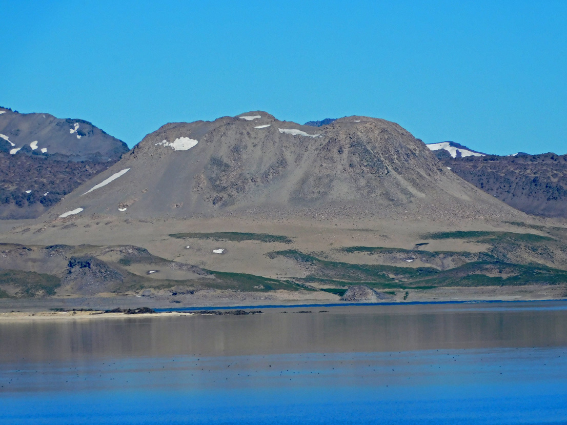
Chile , Laguna del Maule :
Seismology
Seismological activity during this period was characterized by:
32,657 VT-type earthquakes, associated with rock fracturing (volcano-tectonics). The most energetic earthquake, with a local magnitude (LM) of 4.0, was located 2.4 km east-southeast of the center of the lagoon, at a depth of 8.0 km.
29 LP-type earthquakes, associated with fluid dynamics within the volcanic system (Long Period). The magnitude of the strongest earthquake, evaluated using the reduced displacement (RD) parameter, was 14 cm².
One HB-type earthquake, associated with both rock fracturing and fluid dynamics within the volcanic system (Hybrid). This earthquake, with a reduced displacement (RD) of 13 cm² and a local magnitude (LM) of 1.3, occurred 12.9 km west-southwest and at a depth of 8 km from the center of the lagoon.
Fluid Geochemistry
No anomalies in sulfur dioxide (SO₂) emissions into the atmosphere were reported near the volcanic complex, according to data published by the Tropospheric Monitoring Instrument (TROPOMI) and the Sulfur Dioxide Group of the Ozone Monitoring Instrument (OMI).
Satellite Thermal Anomalies
During this period, no thermal alerts were recorded in the area associated with the volcanic complex, according to analytical processing of Sentinel 2-L2A and Landsat 8 satellite images, in false color and thermal bands, respectively.
Geodesy
Geodetic monitoring, carried out using five GNSS stations and satellite images, indicates that:
– System inflation continues, with a maximum vertical uplift rate of 4.5 cm/month at the station closest to the center of the lagoon, slightly lower than in the previous period, but still considered very high.
– Horizontal displacements maintain their trends and, like vertical displacements, show a slight decrease for this period, adjusting to rates below 2.7 cm/month.
– The distance between stations crossing the lagoon from east to west continues to increase, with an increase of 3.5 cm/month.
– Radar interferometry (InSAR) of Sentinel 1A images reveals the deformation pattern and, although some areas still show low coherence, the observed displacement amplitudes coincide with those measured at the GNSS stations. Furthermore, relative displacements of 2 to 4 cm are observed in the Las Nieblas lava flow.
– Modeling indicates that the maximum deformation, occurring beneath the lagoon, has shifted approximately 1.5 km to the southeast compared to previous years.
Consequently, deformation of the volcanic system continues with displacement rates above the average recorded since 2012 and shows slight spatial changes in the source of deformation, indicating increased internal activity within the volcanic complex.
Satellite Geomorphological Analysis
According to the analysis of Sentinel 2 L2A and Planet Scope images, no morphological changes related to volcanic activity were identified.
During the first half of October, seismic activity at the Laguna del Maule Volcanic Complex (CVLM) remained high, with daily productivity exceeding the seismic swarm threshold for much of the period. Seismic activity continues to be distributed across several foci around the lagoon, with preferential epicentral concentration areas in the northern sector, the center of the lagoon, and the Los Espejos sector. Activity was also observed, to a lesser extent, in the Troncoso sector. During this period, a volcano-tectonic (VT) event with a local magnitude of ML 4.0 was recorded, one of the most energetic events in the current activity cycle. This event suggests the involvement of volumetric processes associated with magma mobilization at depth. Concurrently, a continuous spatial migration and diversification of seismic sources are observed, indicating a dynamic evolution of the volcanic system. These processes are developing in line with the trend of accelerated deformation measured by GNSS stations, which maintains high values in historical instrumental records, suggesting the persistence of magmatic inputs and/or internal pressurization.
The integration of these antecedents confirms the instability of the volcanic system, compatible with a YELLOW volcanic technical alert level.
Source : Sernageomin
Photo : Álvaro Vivanco – Volcán Domos del Maule
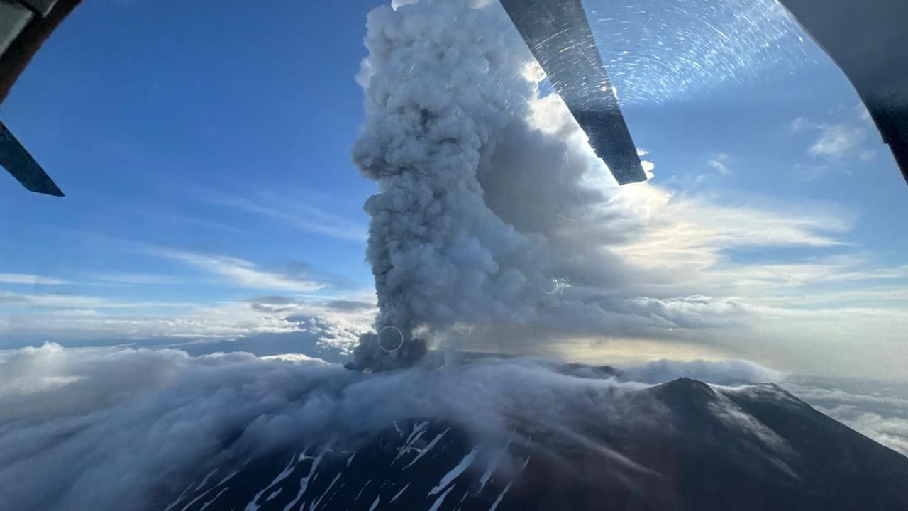
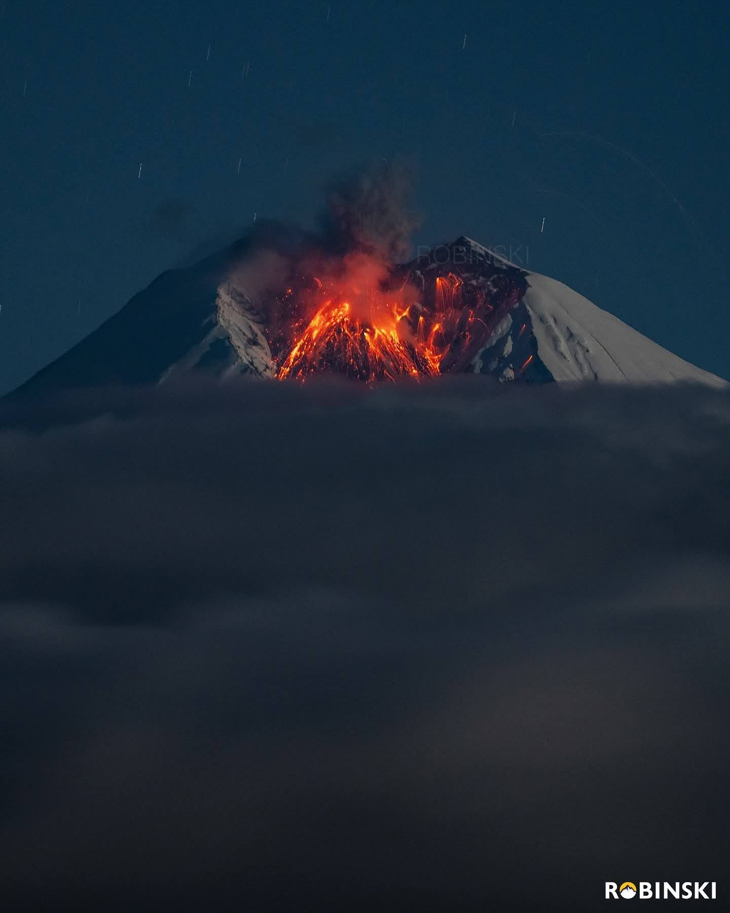
Ecuador , Sangay :
DAILY STATUS REPORT OF SANGAY VOLCANO, Sunday, October 19, 2025.
Information Geophysical Institute – EPN.
Surface Activity Level: Moderate, Surface Trend: No Change
Internal Activity Level: Moderate, Internal Trend: No Change
Seismicity: From October 18, 2025, 11:00 a.m. to October 19, 2025, 11:00 a.m.:
Seismicity:
Below is the count of seismic events recorded at the reference station.
Explosion (EXP): 53
Rainfall/Lahars:
No rainfall has been recorded in the volcanic area. **Heavy rainfall could remobilize accumulated material, generating mud and debris flows that would cascade down the volcano’s flanks and drain into adjacent rivers**.
Emission/Ash Column:
Yesterday afternoon, the GOES-19 satellite recorded an emission of gas and ash reaching 800 meters above the crater, in a southwesterly direction.
In addition, the Washington State Weather Agency (VAAC) reported an emission reaching 800 meters above the crater, in a southwesterly direction.
Observation:
In the early morning, the camera network recorded several episodes of incandescent material falling on the northwest flank, up to 400 meters below the crater level. At the time of writing, the volcano remains cloudy.
Alert Level: Yellow
Source : IGEPN
Photo : Robinsky/ Volcan Sangay / FB.
Costa Rica , Rincon de la Vieja :
ERUPTION REPORT, Rincón de la Vieja Volcano
Location: N10.83 W85.34
Mass elevation: 1,916 m (6,284 ft)
Date: 10/19/2025
Time: 11:46 AM
Plume height (above crater): 3,000 m (9,840 ft)
Plume observation sources: Seismographs, infrasound, webcams, and observations of the surrounding volcano.
Observed activity:
Intense phreatic eruption at Rincón de la Vieja Volcano today, October 19, 2025, at 11:46 AM local time. Acoustic magnitude: 3.9. No ashfall has been reported at the time of writing. The eruptive plume is very rich in water vapor, gases, and aerosols. The vapor and gas plume rose approximately 3,000 meters above the crater, while ash and wet sediment were ejected approximately 500 meters from the main crater floor.
The wind is moving the white eruptive plume westward.
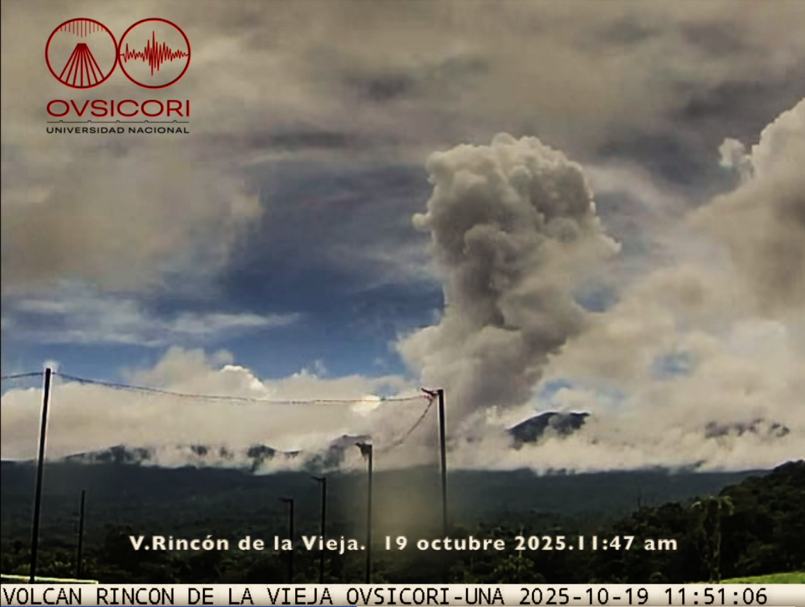
An impressive eruption was recorded at the Rincón de la Vieja volcano in Guanacaste around noon this Sunday. Material rose up to three kilometers high, according to the National Volcanological and Seismological Observatory (OVSICORI). No ash fall has yet been reported.
A few hours before the eruption, seismographs recorded several short, banded tremors, followed by a more significant tremor, and then several hours of decreasing seismic amplitude.
This sequence culminated in the 11:46 a.m. eruption, which generated a plume rich in steam and gas that rose approximately 3,000 meters above the volcano’s summit.
Sources : Ovsicori , Crhoy . com.
Photo : Ovsicori.