September 27 , 2025.
Iceland , Reykjanes Peninsula :
Entering new period of increased likelihood of an eruption
The waiting period for the next event could be up to 3 months
Updated 25 september
Increased likelihood of an eruption from 27 September
The volcano alert level for Reykjanes/Svartsengi is elevated from 1 to 2
A new hazard map is issued
Past behaviour of the Svartsengi volcanic system (since December 2023), has shown variability in magma volumes recharged to the Svartsengi reservoir prior to diking/eruption onset.
Analysis of past events has enabled an estimate of the likely volume range required to trigger the next diking event/eruption.
By using a geodetic model, it is possible to calculate the time needed to recharge these specific volumes, including their associated uncertainties. As of today, it is assessed that the lower bound of 11 million m3 will be reached on 27 September and the upper bound of 23 million m3 on 18 December, provided.
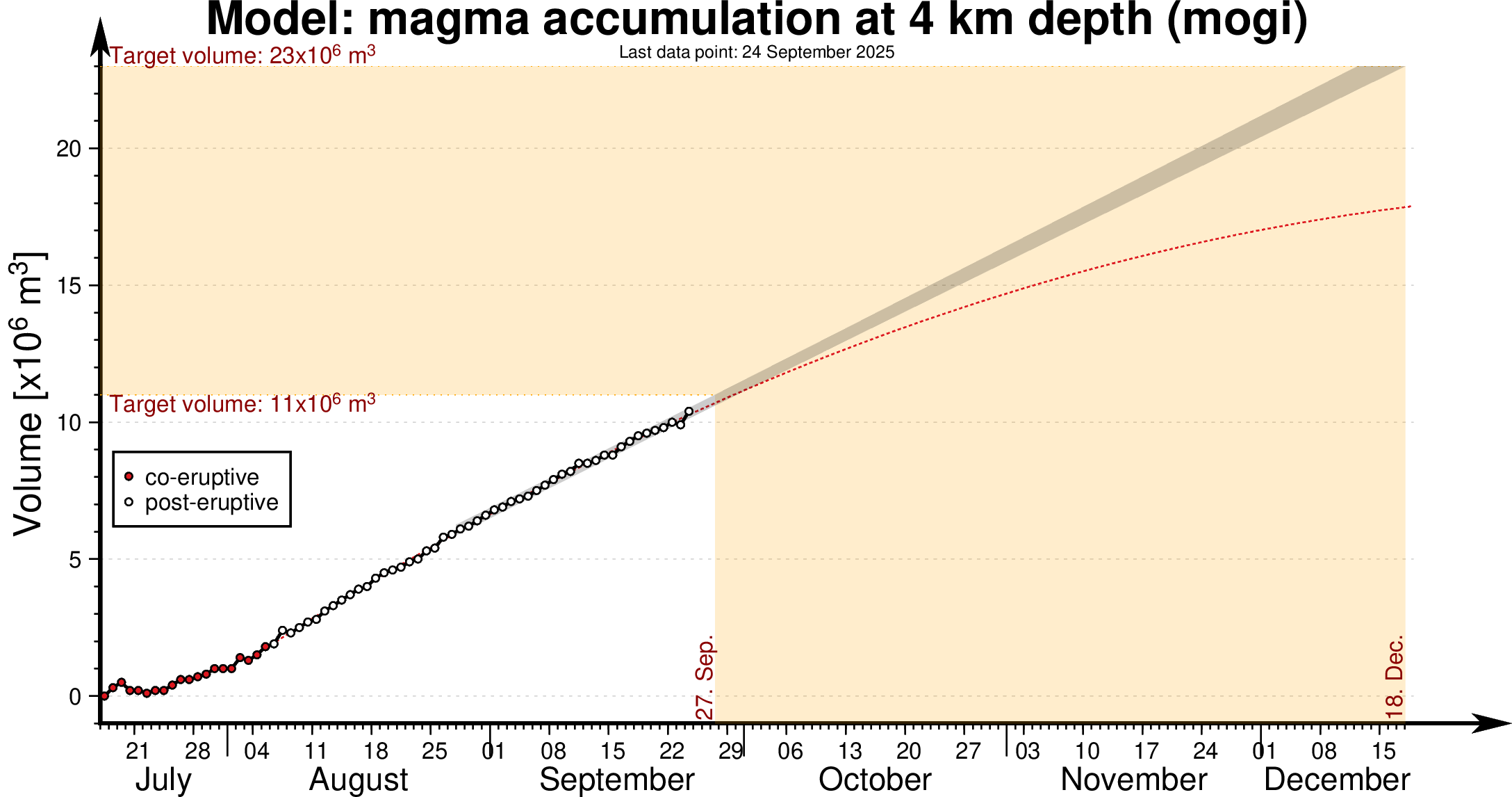
The graph shows magma accumulation at a depth of 4 km beneath Svartsengi from July to 18 December 2025. The black dots indicate the measured magma volume after the last eruption, while the red dots show magma accumulation during the eruption.
The magma inflow rate remains unchanged.
Once the lower volume is reached it is considered that we have entered a period with increased likelihood of a new diking event and eruption. An eruption may occur any time after this lower bound is reached. This time period from 27 September to 18 December represents the medium-term forecast. This forecast will change based on variations in the magma inflow rate and will be updated accordingly. As in previous events the short-term forecast will be issued as soon as the real-time IMO monitoring network detects new activity indicative of a dike propagation.
For these reasons the IMO decided to increase the volcano alert level for Reykjanes-Svartsengi from VALS=1 to VALS=2 and, accordingly, the hazard assessment for the area has been re-evaluated and elevated.
Source : IMO.
Photos : IMO
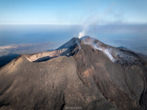
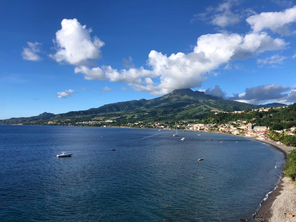
La Martinique , Mount Pelée :
Weekly Report, Paris Institute of Earth Physics, Martinique Volcanological and Seismological Observatory
Saint-Pierre, September 26, 2025 at 5:00 PM (GMT-4)
Volcanic activity increased sharply this week, with 2,267 earthquakes of volcanic origin observed.
Between September 19, 2025 at 4:00 PM (UTC) and September 26, 2025 at 4:00 PM (UTC), the OVSM recorded:
-2,203 volcano-tectonic earthquakes. Most of these low-energy earthquakes were clearly identified as originating from one of the well-known seismically active zones on
Montagne Pelée, located between 1.0 and 1.4 km deep below the volcano’s summit. However, 130 of these earthquakes, of higher energy, were located deeper, between 2.4 km and 4.3 km below the volcano’s summit. Among them, 114 had a local magnitude Mlv greater than Mlv = 0.5; 31 had a magnitude greater than Mlv = 1; and the largest had a magnitude Mlv = 2.16. The shallow volcano-tectonic seismicity is associated with microfracturing in the volcanic edifice, linked to the global reactivation of the volcano observed since 2019.
-57 shallow hybrid earthquakes, including 13 located between 1 km and 2 km deep under the domes of Mount Pelée, in the same area as the volcano-tectonic earthquakes, and with a local magnitude between Mlv = 0.64 and Mlv = 1.49; and 1 located 3.2 km below the volcano’s summit, with a magnitude of Mlv = 1.96. Hybrid seismic signals are enriched in low frequencies and are associated with the circulation of pressurized fluids (gas, hydrothermal fluids) within the volcanic edifice, which contribute to microfracturing.
– 5 shallow, low-energy long-period earthquakes located in the same area as the volcano-tectonic earthquakes. Long-period earthquakes are characterized by signals that contain only low frequencies and are associated with the circulation of fluids within the volcanic edifice.
– 2 deep, low-energy long-period earthquakes, one of which was located 22 km below the volcanic edifice. Long-period earthquakes are characterized by signals
that contain only low frequencies and are associated with the circulation of fluids (magma, supercritical fluids) in the deep parts of the magmatic system.
No earthquakes were felt by the public. However, several volcanic earthquakes had magnitudes approaching those likely to be felt by hikers on Mount Pelée.
The previous week, the OVSM had recorded 651 earthquakes of volcanic origin. As of September 26, 2025, and over the past four weeks, the OVSM has therefore observed a total of 4,033 volcanic earthquakes, an average of 1,008 to 1,009 earthquakes per week.
The seismic energy released by volcanic earthquakes this week shows a significant increase.
Based on data currently being processed, a preliminary estimate shows that the energy released between 01/09 and 26/09 is higher than that released between 01/01/2025 and 31/08/2025 (approximately 775 MJ versus 740 MJ). This level of energy released by volcanic earthquakes is the highest recorded since the beginning of reactivation in 2019.
With the progression of the hypocenters of volcano-tectonic earthquakes to between 1 km and 3 km below sea level, the data recorded this week suggest that mechanical connectivity is beginning to develop between the very superficial parts of the volcano, where seismicity has been primarily concentrated until now, and deeper regions within the edifice, down to approximately 4 km below the surface. Furthermore, the location of the earthquakes reveals a tubular geometry consistent with the presence of a volcanic conduit. However, the deformations of the structure are very slight, and to date, show no marked inflation of the summit area or evidence of deeper deformation.
There is currently no evidence of fumarolic activity on Mount Pelée.
During phases of volcanic reactivation in volcanoes similar to Mount Pelée, it is common to observe seismic activity of varying intensity and frequency, which can evolve rapidly but also cease rapidly without major changes to the system.
The probability of eruptive activity in the short term remains low. However, given all the observations collected since the end of 2018 and their nature, and based on the OVSM-IPGP observations summarized in the latest monthly bulletin (August 2025) and the data recorded over the last 7 days, we cannot rule out a change in the situation in the medium term (months, weeks). Given the inherent uncertainties in predicting the evolution of volcanic processes, the activity is being closely monitored by the OVSM-IPGP, which has strengthened its monitoring resources.
For more details on observations and interpretations of volcanic activity over the longer term, refer to the OVSM’s monthly bulletins.
The volcanic alert level, in accordance with the measures planned by the authorities, is currently YELLOW: vigilance.
Source : Direction de l’OVSM-IPGP
Photo : rci.fm
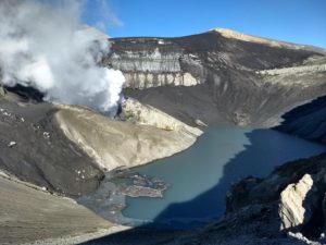
Colombia , Nevado del Ruiz :
Manizales, September 23, 2025, 4:30 p.m.
Regarding the monitoring of the activity of the Nevado del Ruiz volcano, the Colombian Geological Survey (SGC), an entity attached to the Ministry of Mines and Energy, reports that:
During the week of September 16 to 22, 2025, the volcano continued to exhibit unstable behavior. Compared to the previous week, the main variations in the monitored parameters were:
– Seismicity related to fluid dynamics in volcanic conduits decreased, with a decrease in the number of recorded earthquakes and the seismic energy released, particularly for short-duration signals. This week, long-duration signals were recorded again, something not observed since September 7. The energy levels of the seismic signals were mostly low to moderate, and events associated with ash emissions showed an increase in seismic energy. The cameras (conventional or thermographic) used to monitor the volcano and reports from officials of the Los Nevados National Natural Park (PNN) confirmed several pulsed ash emissions and variations in the apparent temperature of the emitted materials.

– Seismic activity associated with rock fracturing processes within the volcanic edifice decreased, both in terms of the number of recorded earthquakes and the seismic energy released. The earthquakes were mainly located in the Arenas crater, at a depth of less than 2 km, measured from the volcano’s summit. To a lesser extent, seismic activity was recorded on the volcano’s south-southeast, southeast, northeast, and northwest flanks, at distances ranging from 1 km to 10 km from the Arenas crater. The earthquake that occurred on September 18 at 3:24 p.m., with a magnitude of 1.1, was the most significant event of the week. It was located in the Arenas crater, at a depth of less than 1 km. Additionally, on September 20, seismic activity related to the activity of the lava dome (protuberance or mound) located at the crater floor was recorded. It was characterized by low energy levels, both in terms of the number of events and the seismic energy released.
The emission of water vapor and volcanic gases, mainly sulfur dioxide (SO₂), into the atmosphere from the Arenas crater showed some variability throughout the week. Estimated values of the flux associated with SO₂ degassing increased slightly compared to those recorded the previous week.
The vertical height of the gas, water vapor, or ash column generally remained below the 600 m measured above the volcano’s summit and reached a maximum height of 1,000 m. During the dispersal, the maximum height reached 1,200 m, a value measured during the ash emission recorded on September 18 at 4:23 a.m. During the week, the direction of dispersal was oriented towards the northwest flank of the volcano and, to a lesser extent, towards the west-northwest and west-southwest flanks. Due to this preferential wind direction, ashfall occurred in the Tumbas sector of the national park.
– When monitoring thermal anomalies at the floor of the Arenas crater using satellite monitoring platforms, detection was limited by the persistence of atmospheric conditions of high cloud cover in the volcanic area. However, low-energy anomalies were reported.
Source et photo : SGC
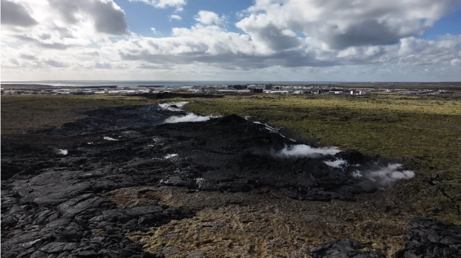
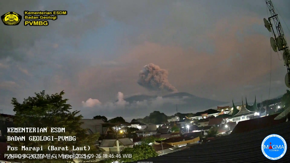
Indonesia , Marapi :
Mount Marapi erupted on Friday, September 26, 2025, at 6:31 p.m. (local time). An ash column was observed about 1,000 m above the summit (about 3,891 m above sea level). The ash column, white to gray in color, was dense and moving eastward. This eruption was recorded by seismograph with a maximum amplitude of 30.4 mm and a duration of 46 seconds.
VOLCANO OBSERVATORY NOTICE FOR AVIATION – VONA
Issued : September 26 , 2025
Volcano : Marapi (261140)
Current Aviation Colour Code : ORANGE
Previous Aviation Colour Code : orange
Source : Marapi Volcano Observatory
Notice Number : 2025MAR076
Volcano Location : S 0 deg 22 min 52 sec E 100 deg 28 min 23 sec
Area : West Sumatra, Indonesia
Summit Elevation : 9251 FT (2891 M)
Volcanic Activity Summary :
Eruption with volcanic ash cloud at 11h31 UTC (18h31 local).
Volcanic Cloud Height :
Best estimate of ash-cloud top is around 12451 FT (3891 M) above sea level or 3200 FT (1000 M) above summit. May be higher than what can be observed clearly. Source of height data: ground observer.
Other Volcanic Cloud Information :
Ash cloud moving to east. Volcanic ash is observed to be white to gray. The intensity of volcanic ash is observed to be thick.
Remarks :
Eruption recorded on seismogram with maximum amplitude 30.4 mm and maximum duration 46 second.
Source et photo : Magma Indonésie .
Guatemala , Fuego :
Atmospheric Conditions: Clear
Wind: East
Precipitation: 20.1 mm
Activity
Slight degassing is observed above the crater, reaching a height of 200 meters and dispersing westward. Weak to moderate Strombolian explosions are recorded at a frequency of 6 to 9 per hour, generating columns of gas and ash reaching an altitude of 4,800 meters. The ash disperses over a distance of 8 to 10 km to the west. Fine ash fallout occurs in localities located on the southwest flank.
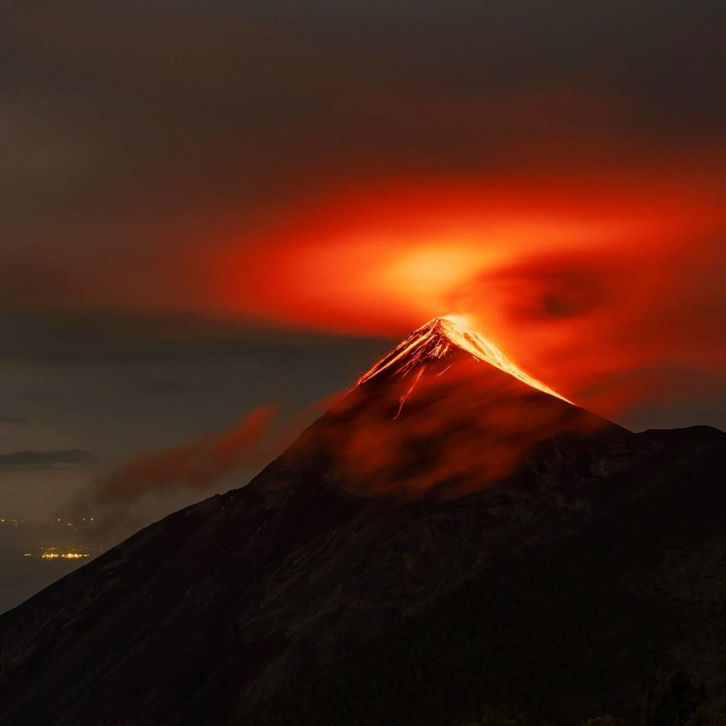
The explosive activity also generates rumbles, shock waves, and noises similar to those of a reactor, due to the continuously expelled gases. During the night and early morning, incandescence can be observed emanating from the crater. In the presence of rain in the afternoon and evening, weak and moderate lahars can form, descending into the various ravines of the volcano. Therefore, follow the recommendations of bulletin BEFGO-013-2025.
Source : Insivumeh
Photo : Diego Rizzo . ( archive)