September 10 , 2025.
Italy , Stromboli :
WEEKLY BULLETIN, from September 1, 2025 to September 7, 2025. (Publication date: September 9, 2025)
ACTIVITY SUMMARY
Based on monitoring data, the following points are highlighted:
1) VOLCANOLOGICAL OBSERVATIONS: During this period, ordinary Strombolian eruptive activity was observed. The total hourly frequency fluctuated between average (9 events/h) and high (18 events/h) values. The intensity of the explosions was low and medium in the North and South-Central crater areas.
2) SEISMOLOGY: The monitored seismic parameters show no significant variation.
3) GROUND DEFORMATION: The ground deformation monitoring networks did not measure any significant variations. 4) GEOCHEMISTRY: SO2 flux at an average level
Soil CO2 flux in the Pizzo area (STR02): Due to technical data transmission issues, no updates are available. The latest recorded values (August 3) are average to high.
The C/S ratio in the plume remains at average values.
Dissolved helium isotope ratio (R/Ra) in the thermal aquifer: No updates are available. The latest values (July 9) are high.
Soil CO2 flux in the Scari area is average to high.
5) SATELLITE OBSERVATIONS: Thermal activity observed by satellite in the summit area was generally low, with some isolated moderate thermal anomalies.
VOLCANOLOGICAL OBSERVATIONS
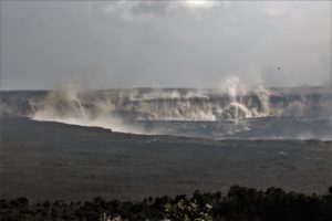
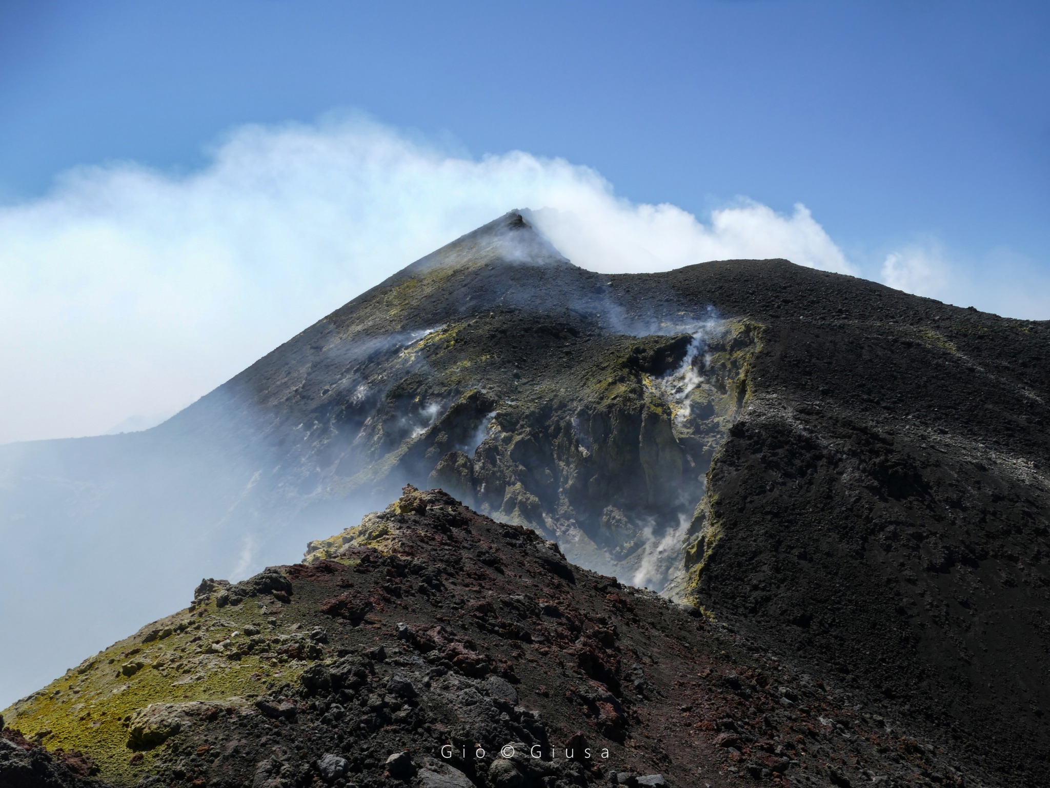
During the observation period, Stromboli’s eruptive activity was characterized by analyzing images recorded by the INGV-OE surveillance cameras located at 190 m (SCT-SCV) and at Punta dei Corvi (SPCT). Explosive activity was mainly produced by four (4) eruptive vents located in the North Crater area and by at least two (2) vents located in the Central-South area.
Observations of Explosive Activity Captured by Surveillance Cameras
Four active vents were observed in the North Crater area, producing low-intensity explosive activity (less than 80 m in height) and occasionally medium-intensity explosive activity (less than 150 m in height). The eruptive products were mainly coarse materials (bombs and lapilli). The average explosion frequency ranged from 8 to 16 events per hour. Fine-grained explosions of moderate to low intensity were observed in the area of the Centre-Sud (CS) crater. The average frequency of explosions varied from less than one event per hour to two events per hour.
Source : INGV
Photo : Stromboli stati d’animo / Sebastiano Cannavo
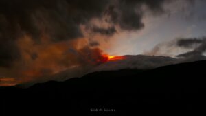
Italy / Sicily , Etna :
WEEKLY BULLETIN, from September 1, 2025 to September 7, 2025. (Publication date: September 9, 2025)
ACTIVITY SUMMARY
Based on monitoring data, the following points are highlighted:
1) VOLCANOLOGICAL OBSERVATIONS: Variable rate degassing in the summit craters.
2) SEISMOLOGICAL OBSERVATIONS: No seismic activity due to fracturing with Ml >= 2.0. Tremor amplitude at a generally low level.
3) INFRASOUND: Low infrasound activity.
4) GROUND DEFORMATION: GNSS (HF) and inclinometer networks monitoring ground deformation have not measured any significant changes over the past week.
5) GEOCHEMISTRY: SO2 flux at an average level.
The CO2 flux from the soil remains low.
Partial pressure of dissolved CO2 in groundwater (Ponteferro): No update available.
Helium isotope ratio at peripheral sites: The latest data from August 27 remain high.
6) SATELLITE OBSERVATIONS: Thermal activity observed by satellite in the summit area was generally low, with some isolated moderate thermal anomalies.
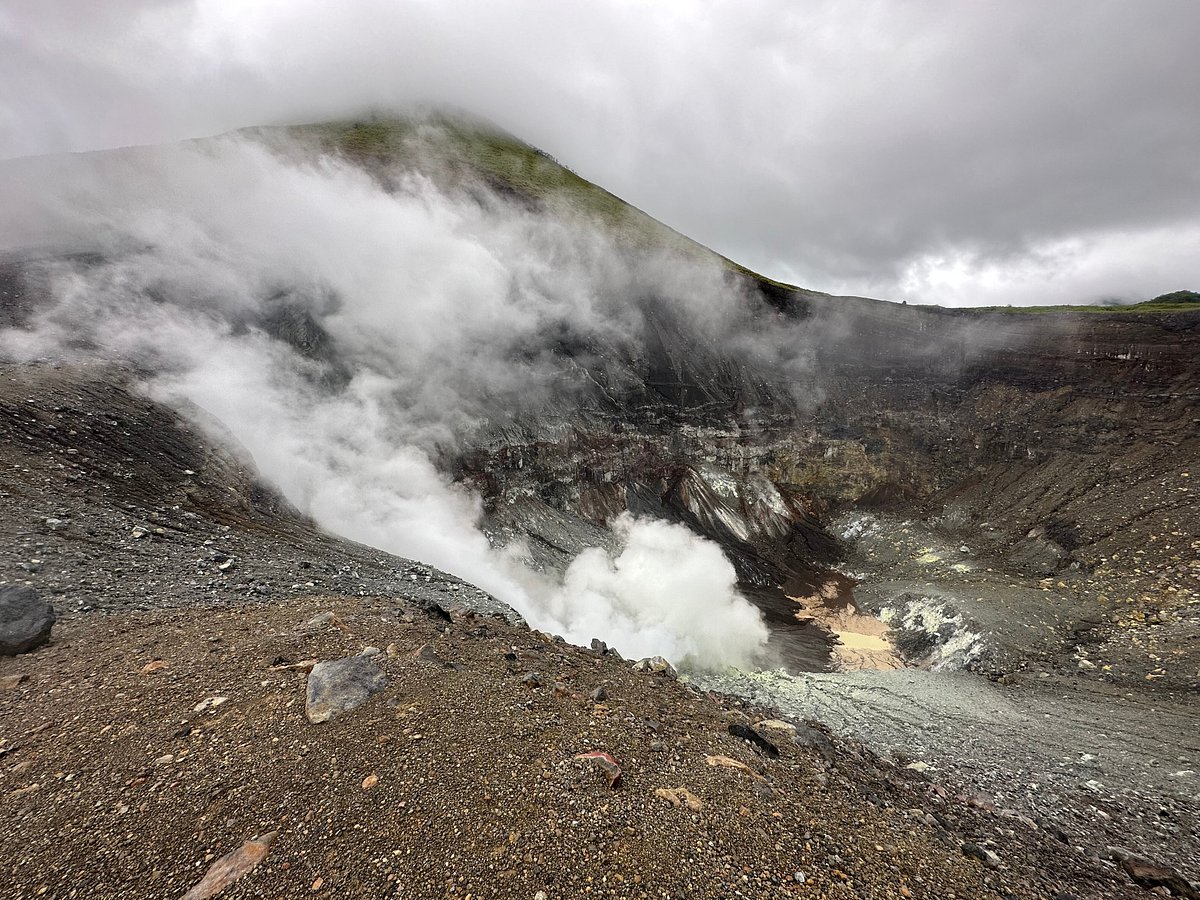
VOLCANOLOGICAL OBSERVATIONS
During the observation period in question, Mount Etna’s volcanic activity was monitored through the analysis of images from the INGV (Osservatorio Etneo) surveillance camera network,
INGV-OE.
The Northeast Crater (CNE) is experiencing pulsed degassing generated by a vent located at the crater floor. The other craters, on the other hand, show diffuse degassing of lesser intensity, mainly attributable to various fumarolic systems, while the Bocca Nuova (BN) crater shows degassing generated mainly by the pit crater BN1.
Source : INGV
Photo : Gio Giusa
Indonesia , Lokon-Empung :
Visual Observations
The volcano is clearly visible. Moderate to intense white smoke was observed from the main crater, approximately 25 to 50 meters above the summit. The weather was clear to cloudy, with light to moderate northwest winds.
Seismic Observations
Two emission earthquakes with an amplitude of 5 to 7 mm and a duration of 8 to 9 seconds.
One nonharmonic tremor with an amplitude of 5 mm and a duration of 75 seconds.
Nine shallow volcanic earthquakes with an amplitude of 3 to 8 mm and a duration of 3 to 5 seconds.
Recommendations
(1) The public and tourists are advised not to approach or participate in activities within a 2.5 km radius of the Tompaluan crater (activity center). (2) In the event of an eruption and ash fall, the public is advised to stay indoors. Outdoors, it is recommended to wear protection for the nose, mouth and eyes (goggles).
Mount Lokon crater emits firelight, PGA Post reports
Manado (ANTARA) – The Head of the Volcano Security Post (PGA), Armando Manguleh, stated that firelights have been observed from the Tompaluan crater of Mount Lokon in Tomohon City, North Sulawesi, since September 4, 2025.
« The firelights have been visible since September 4, 2025, » said Manguleh in Tomohon on Sunday.
The appearance of firelights indicates magma activity rising to the surface, heating the ground, including solfatara.
« That’s what causes the firelights visible in the Tompaluan crater, » he said.
He said the potential for an eruption is possible due to the still-high activity and rising ground temperatures.
He said the firelights could persist or disappear, depending on seismic activity, continued magma supply, and continued heating of the ground.
Armando explained that in 2008, firelights appeared from the Tompaluan crater of Mount Lokon, but no eruption occurred at that time.
« The appearance of the fire will be followed by an eruption three years later. When the eruption occurs, residents will be evacuated, » he said.
The Geological Agency of the Ministry of Energy and Mineral Resources (ESDM) raised the status of Mount Lokon from Alert (Level II) to Standby (Level III) starting Wednesday, September 3, at 12:00 p.m. local time.
The status upgrade follows a significant increase in the number of earthquakes, reaching more than 100 per day, up from the normal frequency of only three per day.
Sources : Magma Indonésie , En Antara News .
Photo : Paul S .
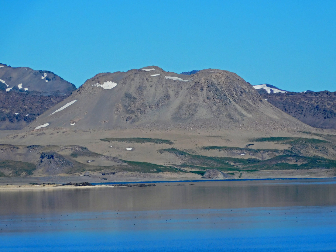
Chile , Laguna del Maule :
Seismology
Seismological activity during this period was characterized by:
6,481 VT-type earthquakes, associated with rock fracturing (volcano-tectonics). The most energetic earthquake, with a local magnitude (LM) of 2.9, was located 7.1 km west-northwest and at a depth of 8.0 km from the center of the lagoon.
Nine LP-type earthquakes, associated with fluid dynamics within the volcanic system (Long Period), were observed. The magnitude of the strongest earthquake, evaluated using the reduced displacement (RD) parameter, was 4 cm².
One TR-type earthquake, associated with sustained fluid dynamics within the volcanic system (TRemor), was observed. The magnitude of the earthquake, evaluated using the reduced displacement (RD) parameter, was 9 cm².
Fluid Geochemistry
No atmospheric sulfur dioxide (SO2) emission anomalies were reported in the area near the volcanic complex, according to data published by the Tropospheric Monitoring Instrument (TROPOMI) and the Sulfur Dioxide Group of the Ozone Monitoring Instrument (OMI).
Geodesy
Geodetic activity for the period was characterized by:
– GNSS vertical deformation rates, with maximum magnitude variations of 2.6 cm/month at the station closest to the center of the lagoon, indicating a slight decrease in internal activity reflected at the surface compared to the increase in activity measured from mid-May to the end of July of this year;
– Horizontal variation rates at GNSS monitoring stations, with variations of approximately 2.6 cm/month, a value considered high. – An increase in the rate of variation of GNSS monitoring lines (distance between GNSS stations), reaching a maximum of 3.6 cm/month for the reported period, a value consistent with the increase in activity measured in previous parameters.
Radar interferometry (InSAR) of Sentinel 1A (Single Look Complex-SLC) images shows no signs of deformation due to low coherence caused by the high presence of snow in the area.
Consequently, the activity associated with the deformation of the volcanic system remains above the historical average, demonstrating that the increase in internal activity within the volcanic complex continues, albeit at a slower pace.
Satellite geomorphological analysis
No morphological variations associated with volcanic activity were identified from Planet Scope and Sentinel 2 L2A satellite images.
The Laguna del Maule volcanic complex has experienced a progressive increase in volcano-tectonic seismicity, with the appearance of various swarms located mainly in the Troncoso-Nieblas sectors (southwest), in the eastern sector of the lagoon, and in the center, near the calculated zone of maximum deformation. A notable VT seismic swarm persisted until the publication of this report, accompanied by energetic seismicity during these September days.
These processes have occurred simultaneously in recent months, with an increase in deformation rates recorded by GNSS stations, particularly on the PUEL-MAU2 line, which has reached historically high levels. The integration of these historical events, along with the temporal and spatial evolution observed in the instrumental records, shows an intensification and diversification of the complex’s internal dynamics.
Overall, current parameters exceed their reference levels and confirm a scenario of ongoing volcanic activity. Therefore, the Volcanic Technical Alert remains in effect at:
YELLOW TECHNICAL ALERT: Changes in the behavior of volcanic activity
Source : Sernageomin
Photo : Álvaro Vivanco – Volcán Domos del Maule.
Colombia , Chiles / Cerro Negro :
San Juan de Pasto, September 9, 2025, 5:10 p.m.
Regarding the monitoring of the activity of the Chiles-Cerro Negro Volcanic Complex (CVCCN), the Colombian Geological Survey (SGC), an entity affiliated with the Ministry of Mines and Energy,
reports that:
From September 2 to 8, 2025, the main variations in the monitored parameters compared to the previous week were:
● An increase in the frequency of earthquakes was observed, with similar levels of released seismic energy. Seismicity associated with fracturing processes remained dominant, along with a significant number of earthquakes related to fluid dynamics.
● Fracture earthquakes were located mainly at the summit and in the collapse zone of the Chiles volcano, at distances of less than 1.5 km, at depths between 2 and 4 km from its summit (approximately 4,700 m above sea level), and with a maximum magnitude of 2.3.
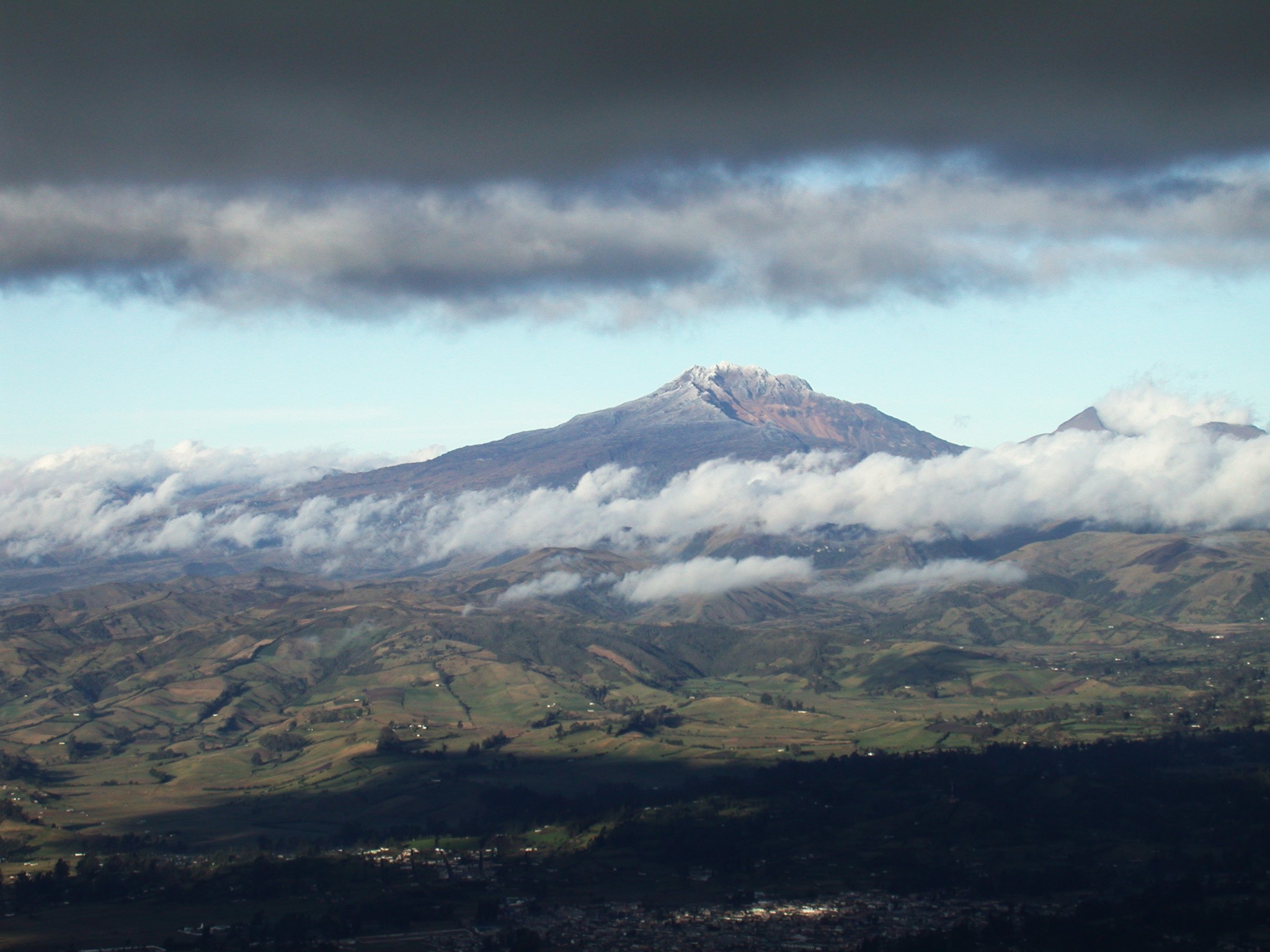
● Data recorded by satellite sensors and ground-based measuring stations continue to indicate changes related to inflationary processes in the volcanic area.
Based on the assessment and correlation of monitored parameters, the SGC recommends closely monitoring developments through weekly bulletins and other information published through our official channels, as well as instructions from local and departmental authorities and the National Disaster Risk Management Unit (UNGRD).
Volcanic activity remains on alert. Yellow: Active volcano with changes in the baseline behavior of monitored parameters and other manifestations.
Source et photo : SGC.