August 12 , 2025.
Italy / Sicily , Etna :
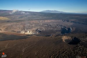
Etna Activity Update, August 10, 2025, 11:03 (09:03 UTC)
The Osservatorio Etneo, the National Institute of Geophysics and Volcanology, reports the opening of an effusive vent.
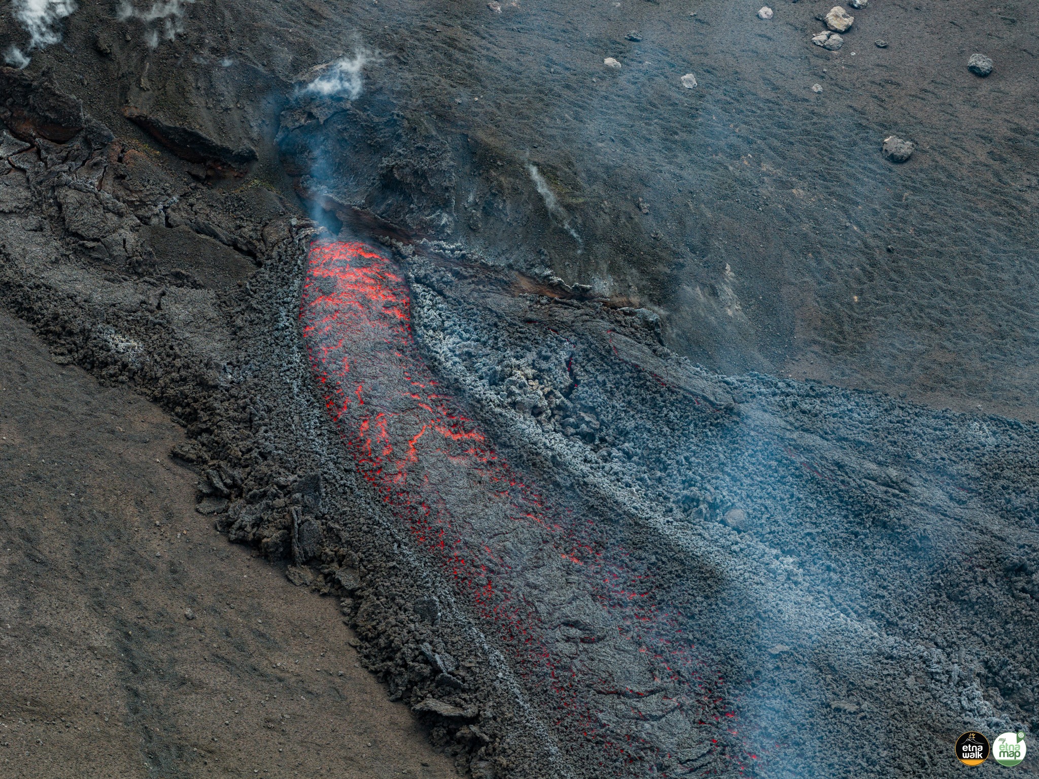
In the morning, a lava flow erupted at the summit, at an altitude of approximately 3,000 m, causing the opening of an effusive vent on the southern slope of Bocca Nuova. The flow is moving southward; INGV personnel are currently conducting field surveys.
From a seismic perspective, no significant changes have been reported. The source of the volcanic tremor is located at an altitude of 2,800 m, between Voragine and the Northeast Crater. No significant infrasound activity has been reported. Analysis of ground deformation network signals shows a very small compression variation, of about one nano-strain, at the Mount Ruvolo Deformation Meter (DRUV) between 03:30 and 04:00 UTC. No signal beyond the background variability is detectable at the inclinometer and GNSS network stations.
Etna Activity Statement, August 10, 2025, 7:09 PM (5:09 PM UTC)
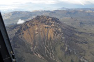
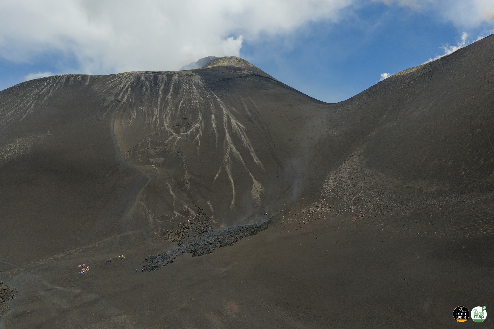
The Osservatorio Etneo, the National Institute of Geophysics and Volcanology, announces that following field surveys carried out today by INGV personnel using a drone, the lava flow from an eruptive fracture at an altitude of 3,100 m, oriented north-northeast/south-southwest, has been mapped. It is 33 m long. The flow is located in the saddle between the Bocca Nuova and the Southeast Crater; at 2:00 PM, the lava front was at an altitude of 3,070 m.
In total, the flow had traveled 125 m in a southwesterly direction, and the effusive activity was weak. The Southeast Crater was experiencing explosive activity, with ejection of lava fragments that fell back onto the crater rim and, sporadically, onto the cone slopes. From a seismic point of view, volcanic tremors remain of medium intensity and their sources are located at approximately 2,900 meters above sea level, between the Voragine and Northeast craters. Infrasound activity remains extremely low, both in number and amplitude, and their location is attributable to the Northeast and Southeast craters. Analysis of ground deformation signals reveals no significant changes in the GNSS, inclinometric and extensometric networks.
Etna Activity Update, August 12, 2025, 12:37 PM (10:37 UTC)
The Etna Observatory of the National Institute of Geophysics and Volcanology (INGV) reports that, following field surveys conducted this morning by the INGV team, the lava flow
is no longer being fed. This activity had already decreased considerably last night.
Strombolian activity continues at the Southeast Crater, with the emission of ballistic ash that falls back inside the crater. This activity is accompanied by intermittent ash emissions that quickly disperse in the summit area. Volcanic tremor has remained average, and the sources appear to be located between the Northeast Crater and the Voragine Crater, at an altitude of approximately 2,800 meters above sea level. Infrasound activity is moderate, both in number of events and amplitude, and is located primarily near the Northeast Crater and occasionally near the Southeast Crater.
Over the past few hours, data from ground deformation monitoring networks have not shown any significant changes.
Updates will be provided promptly, and in any case within 3 hours of the publication of this press release.
Source : INGV.
Photo : Etna , Etnawalk / Giuseppe Distefano / Marco Restivo / FB
Philippines , Taal :
TAAL VOLCANO ADVISORY 10 August 2025 ,2:00 PM
This is a notice of increased seismic energy release from Taal Volcano.
Since 05:25 AM today, 10 August 2025, stations of the Taal Volcano Network (TVN) situated on Taal Volcano Island (TVI) have been recording a pronounced increase in real-time seismic energy measurement, or RSAM, simultaneous with continuing volcanic tremor. A total of nineteen (19) volcanic earthquakes has been recorded by the TVN since 09 August 2025. Visual observations noted a moderate to voluminous plume from the Taal Main Crater since the start of RSAM increase. Taal has been degassing low levels of sulfur dioxide or SO2 since June 2025 with the latest emission measured on 8 August 2025, averaging 374 tonnes/day. These sharp increase in RSAM and vigorous steaming from the Main Crater may lead to a phreatic or even a minor phreatomagmatic eruption.
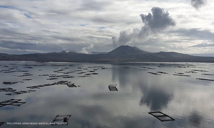
DOST-PHIVOLCS reminds the public that Alert Level 1 prevails over Taal Volcano, which means that it is still in abnormal condition and should not be interpreted to have ceased unrest nor ceased the threat of eruptive activity. At Alert Level 1, sudden steam-driven or phreatic or minor phreatomagmatic eruptions, minor ashfall and lethal accumulations or expulsions of volcanic gas can occur and threaten areas within TVI. DOST-PHIVOLCS strongly recommends that entry into TVI, Taal’s Permanent Danger Zone or PDZ, especially the vicinities of the Main Crater and the Daang Kastila fissure, must remain strictly prohibited. Local government units are advised to continuously prepare for potential recurrence of volcanic SO2 increases and exposure of their communities and undertake appropriate response measures to mitigate the health impacts of these hazards. Lastly, civil aviation authorities must also advise pilots to avoid flying above TVI as ash from any sudden eruption can be hazardous to aircraft.
DOST-PHIVOLCS is closely monitoring Taal Volcano’s activity and any new significant development will be immediately communicated to all stakeholders.
Source : Phivolcs
Photo : CNNPH , Marcello Teofilo ( archive)
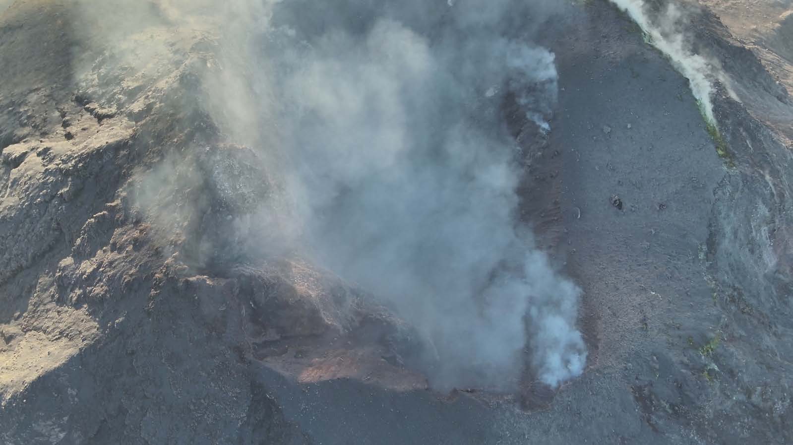
Indonesia , Lewotobi Laki – Laki :
SPECIAL REPORT ON THE CHANGE IN THE ACTIVITY LEVEL OF MOUNT LEWOTOBI LAKI-LA, FROM LEVEL IV (AWAS) TO LEVEL III (SIAGA) ON AUGUST 10, 2025, 3:00 PM WITA
The volcano was clearly visible until it was covered by thick fog. White, thin, moderate to thick smoke escaping from the main crater was observed approximately 50-1,200 meters from the summit. An eruption occurred at an altitude of 800-18,000 meters from the summit, with a gray eruptive column. Avalanches were observed at a distance of 700 meters from the summit, and the landslide direction was northwest.
Seismic data from August 1 to 10, 2025, included:
6 eruption earthquakes,
21 avalanche earthquakes,
68 emission earthquakes,
9 harmonic tremors,
212 non-harmonic tremors,
91 low-frequency earthquakes,
245 deep volcanic earthquakes,
31 local tectonic earthquakes,
43 distant tectonic earthquakes,
1 continuous tremor with a dominant amplitude of 4.4 mm.
The seismic data indicate a decreasing trend in volcanic activity toward short-term stability, with a predominance of shallow and surface earthquakes. The significant decrease in eruption earthquakes indicates a reduction in internal pressure, while the vent is unblocked, producing thin to thick smoke with low to moderate pressure.
Eruption earthquakes have significantly decreased, while harmonic tremors, non-harmonic tremors, and low-frequency earthquakes still dominate, but with a decreasing trend. No shallow volcanic earthquakes have been recorded, indicating the absence of shallow blockages. The system is therefore in an open phase, allowing magma and gas to move freely. The number of deep volcanic earthquakes has also decreased, indicating a reduction in the supply of new magma at depth.
Monitoring of deformation using a tiltmeter after the eruption on August 1, 2025, showed a stabilization of the movement. The x-axis, which had been decreasing sharply since mid-May, is now tilted and stagnant, while the y-axis, which had been rising until the end of July, is flat with slight fluctuations. This pattern indicates a relatively stable phase or temporary lull in activity, although signs of new magma inflow persist at a slow pace.
GNSS data from the same period show a slowdown in uplift to a point of stagnation, indicating that material has been released and that the volcano’s body is undergoing deflation. Although magma inflow from the depths is still present, its movement toward the shallow zone is reduced, and no significant inflow has been observed. As of August 9, 2025, no signs of rapid inflation have been detected, indicating that the system is in a pressure-release phase with the potential for a small- to medium-sized, or phreatic, eruption.
Based on the results of a comprehensive analysis and assessment of visual and instrumental monitoring, the activity level of Mount Lewotobi Laki-laki has been downgraded from Level IV (AWAS) to Level III (SIAGA). As of August 10, 2025 at 3:00 PM WITA.
Source et photo : PVMBG
Indonesia , Marapi :
Mount Marapi erupted on Tuesday, August 12, 2025, at 8:39 a.m. (local time). An ash column was observed about 1,600 m above the summit (about 4,491 m above sea level). The ash column, white to gray in color, was dense and moving northeast. At the time of writing, the eruption was still ongoing.
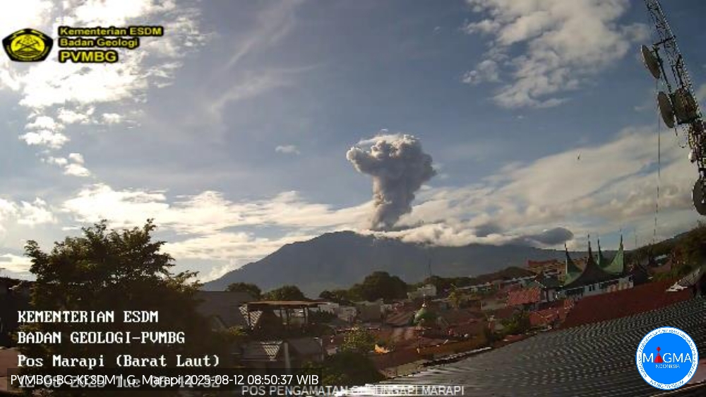
VOLCANO OBSERVATORY NOTICE FOR AVIATION – VONA
Issued : August 12 , 2025
Volcano : Marapi (261140)
Current Aviation Colour Code : ORANGE
Previous Aviation Colour Code : orange
Source : Marapi Volcano Observatory
Notice Number : 2025MAR059
Volcano Location : S 0 deg 22 min 52 sec E 100 deg 28 min 23 sec
Area : West Sumatra, Indonesia
Summit Elevation : 9251 FT (2891 M)
Volcanic Activity Summary :
Eruption with volcanic ash cloud at 01h39 UTC (08h39 local).
Volcanic Cloud Height :
Best estimate of ash-cloud top is around 14371 FT (4491 M) above sea level or 5120 FT (1600 M) above summit. May be higher than what can be observed clearly. Source of height data: ground observer.
Other Volcanic Cloud Information :
Ash cloud moving to northeast. Volcanic ash is observed to be white to gray. The intensity of volcanic ash is observed to be thick.
Remarks :
Eruption recorded on seismogram with maximum amplitude 30.4 mm and maximum duration 34 second.
Source et photo : Magma Indonésie
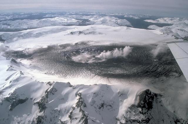
Chile , Hudson :
Special Report on Volcanic Activity (REAV), Aysen del General Carlos Ibanez del Campo Region, Hudson Volcano, August 10, 2025, 11:55 PM local time (Continental Chile)
The National Geology and Mining Service of Chile (SERNAGEOMIN) announces the following preliminary information, obtained using the monitoring equipment of the National Volcanic Monitoring Network (RNVV), processed and analyzed at the Southern Andean Volcano Observatory (OVDAS):
On Sunday, August 10, 2025, at 11:24 PM (Monday, August 11, at 3:24 AM UTC), monitoring stations installed near Hudson Volcano recorded an earthquake associated with both rock fracturing and fluid dynamics within the volcanic system (Hybrid Type).
The characteristics of the highest-energy earthquake after its analysis are as follows:
TIME OF ORIGIN: 11:24 PM local time (03:24 UTC)
LATITUDE: 45.924°S
LONGITUDE: 72.973°W
DEPTH: 7.4 km
LOCAL MAGNITUDE: 2.5
REDUCED DISPLACEMENT: 873 cm²
Observation:
Prior to this event, volcano tectonic (VT) seismicity was recorded, but with lower magnitudes.
The technical volcanic alert remains at GREEN.
Source : Sernageomin
Photo : Norm Banks, 1991 (U.S. Geological Survey).