August 07 , 2025 .
Hawaii , Kilauea :
HVO/USGS Volcanic Activity Notice
Current Volcano Alert Level: WATCH
Current Aviation Color Code: ORANGE
Issued: Wednesday, August 6, 2025, 2:06 AM HST
Source: Hawaiian Volcano Observatory
Notice Number: 2025/H345
Location: N 19 deg 25 min W 155 deg 17 min
Elevation: 4091 ft (1247 m)
Area: Hawaii
Volcanic Activity Summary:
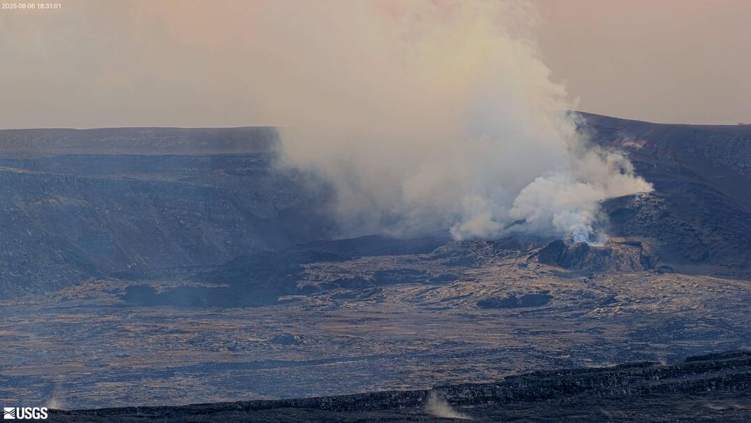
Episode 30 vigorous fountaining of the ongoing Halemaʻumaʻu eruption began at approximately 1:20 a.m. HST on august 6 and is currently producing broad fountains150-300 feet (45-90 meters) high from the north vent. Lava flows from the north vent have covered about 20% of the floor of Halemaʻumaʻu crater. There is a line of small fountains that formed south of the old south vent area that are producing lower volume flows. This appears to be a new vent for this eruption and seems to be associated with a cluster of small earthquakes just south of Halemaʻumaʻu. Past episodes have produced incandescent lava fountains over 1000 feet (300 meters) high that produce eruptive plumes up to 20,000 feet (6000 meters) above ground level. According to the National Weather Service, winds are light and variable from the north direction, which suggests that volcanic gas emissions and volcanic material may be distributed to the south but may fall in a broader pattern than during typical trade winds.
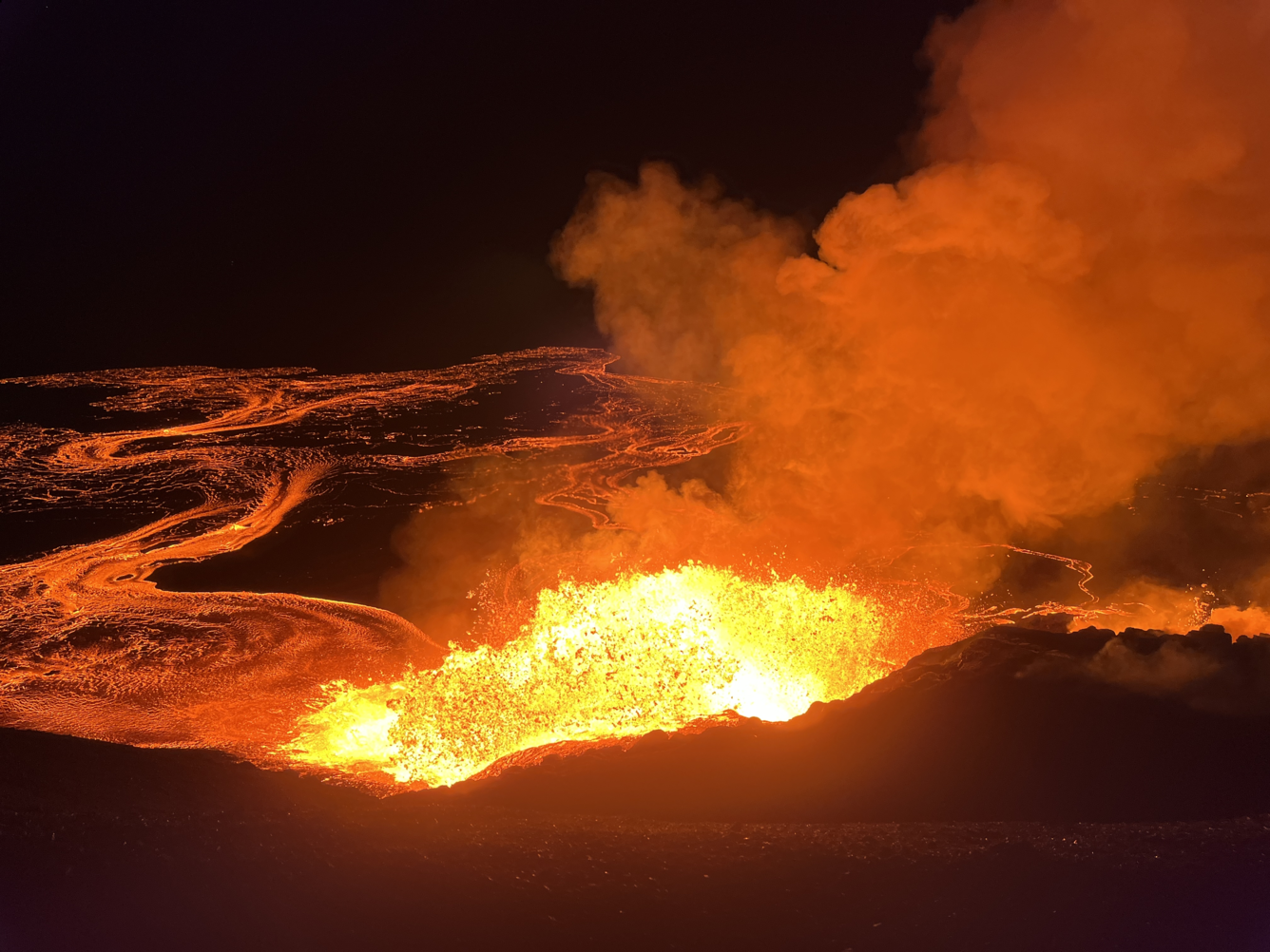
Early in the morning on August 6, Hawaiian Volcano Observatory geologists visited the western rim of Halemaʻumaʻu crater to observe Kīlauea summit eruption episode 30. Lava fountains were reaching about 70 meters (230 feet) above the north vent at the time.
All eruptive activity is confined to Halemaʻumaʻu crater within Hawaiʻi Volcanoes National Park; commercial airports in Hawaii County (KOA and ITO) will not be affected by this activity.
Episode 30 was preceded by spatter fountains and vigorous overflows that began at approximately 12:56 a.m. and continued to increase in intensity until about 1:20 a.m., when sustained, energetic fountaining began.
Inflationary tilt reached just over 19 microradians since the end of the last episode. Seismic tremor began increasing and tilt at UWD switched from inflationary to deflationary at about 12:56 a.m HST, about the same time lava flows began erupting onto the crater floor. Strong tremor and increased deflation accompanied the onset of vigorous sustained fountaining at about 1:20 a.m. HST.
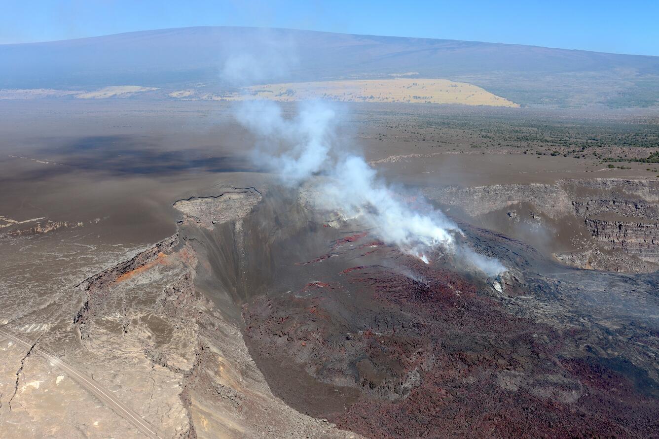
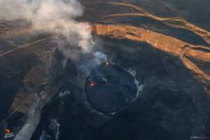
This aerial view of the complex tephra cone built in recent months around the Halemaʻumaʻu eruptive vents was captured on August 5. The cone has been built against the western wall of Kaluapele (Kīlauea caldera), with tephra also forming a hill atop the caldera rim. The cone around the vent is built from hot tephra deposited by the lava fountains, and portions can remain semi-fluid for hours. These hot, unstable portions of the cone will flow during and shortly after the lava fountaining, creating large cracks in the cone flank and producing a deposit that resembles rubbly ʻaʻā lava.
Most episodes of Halemaʻumaʻu lava fountaining since December 23, 2024, have continued for around a day or less and have been separated by pauses in eruptive activity lasting generally at least several days.
Some unusual earthquakes within Kaluapele, the summit caldera, just south of the vents within Halemaʻumaʻu have accompanied the start of this eruption. No changes have been detected in the East Rift Zone or Southwest Rift Zone.
Kīlauea Volcano Alert Level/Aviation Color Code remain at WATCH/ORANGE. All current and recent activity is within Hawaiʻi Volcanoes National Park.
Issued: Wednesday, August 6, 2025, 1:23 PM HST
Volcanic Activity Summary:
Episode 30 of the ongoing Halemaʻumaʻu eruption ended abruptly at 12:55 p.m. HST on August 6 after 12 hours of continuous fountaining. Lava flows continued to drain down the north cone for about 5 minutes after fountaining ceased.
The north vent stopped vigorous fountaining at approximately 12:55 p.m. HST marking the end of the episode. The south vent stopped erupting at approximately 12:50 p.m. HST, Lava fountains reached up to 300 ft (90 m) during this episode. A new fissure vent that transected the south wall of Halemaʻumaʻu ceased erupting at 4:40 a.m. HST on the morning of August 6. Volcanic gas emissions have greatly decreased. Lava flows from this episode on the floor of Halemaʻumaʻu within the southern part of Kaluapele (Kīlauea caldera) may continue to exhibit slow movement or incandescence as they cool and solidify over the coming days.
The Uēkahuna tiltmeter (UWD) recorded about 22.5 microradians of deflationary tilt during this episode. The end of the eruption was coincident with a rapid change from deflation to inflation at the summit and a decrease in seismic tremor intensity.
Most episodes of Halemaʻumaʻu lava fountaining since the eruption started on December 23, 2024, have continued for around a day or less and have been separated by pauses in eruptive activity lasting generally at least several days.
Source : HVO
Photos : USGS / N. Deligne , USGS / M. Bagnardi.
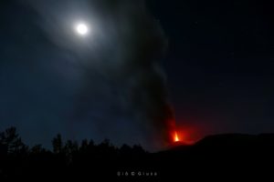
Kamchatka , Klyuchevskoy :
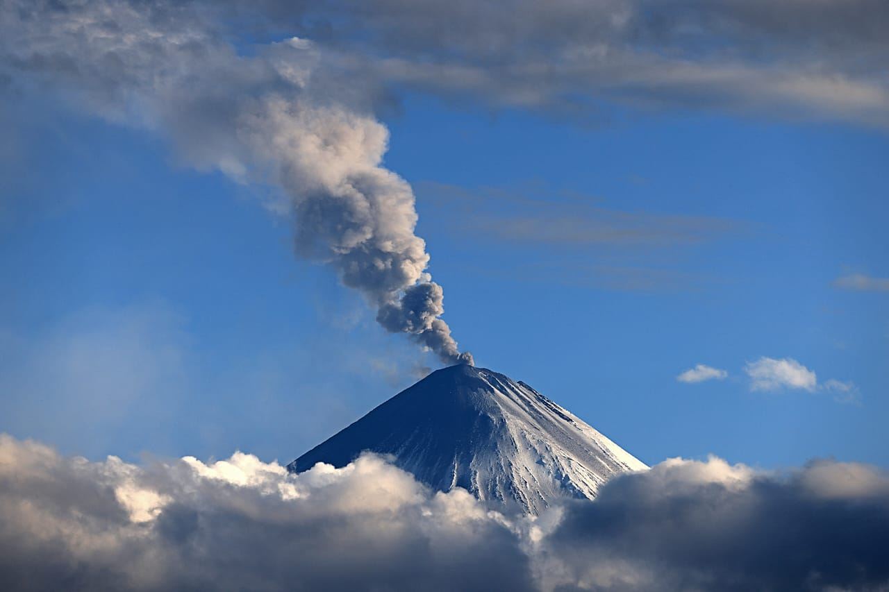
The Kamchatkan Volcanic Eruption Response Team (KVERT) reported that eruptive activity at Klyuchevskoy’s summit crater continued during 30 July-5 August. Satellite data showed a strong thermal anomaly at the volcano all week. Since 30 July a lava flow has been moving down the WSW flank, accompanied by phreatic explosions. Satellite data at 23h15 on 1 August showed an ash plume extending for 150 km to the SE. Ash seen in satellite imagery at 06h13 on 2 August was rising up to 7-8 km (23,000-26,200 ft) a.s.l. and drifting 50 km E. Additional satellite data from 4 August at 04h32 showed ash reaching up to 7.5 km (24,600 ft) a.s.l. and extending for 50 km to the NE. Two lava flows were reported on 4 August effusing down the W and SE flanks, with ash rising up to 7 km (23,000 ft) a.s.l. and drifting for 600 km to the SE. The Aviation Color Code remained at Orange (the second highest level on a four-color scale). Dates and times are provided in Coordinated Universal Time (UTC); specific events are indicated in local time where specified.
Klyuchevskoy is the highest and most active volcano on the Kamchatka Peninsula. Since its origin about 6,000 years ago, this symmetrical, basaltic stratovolcano has produced frequent moderate-volume explosive and effusive eruptions without major periods of inactivity. It rises above a saddle NE of Kamen volcano and lies SE of the broad Ushkovsky massif. More than 100 flank eruptions have occurred during approximately the past 3,000 years, with most lateral craters and cones occurring along radial fissures between the unconfined NE-to-SE flanks of the conical volcano between 500 and 3,600 m elevation. Eruptions recorded since the late 17th century have resulted in frequent changes to the morphology of the 700-m-wide summit crater. These eruptions over the past 400 years have originated primarily from the summit crater, but have also included numerous major explosive and effusive eruptions from flank craters.
Sources: Kamchatkan Volcanic Eruption Response Team (KVERT) , GVP
Photo : via Vulcaniya FB.
Kamchatka , Krasheninnikov :
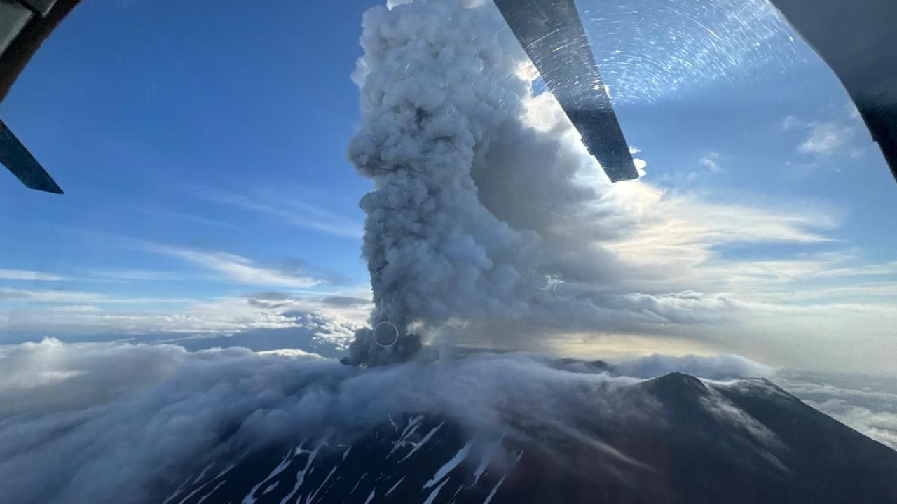
The Kamchatkan Volcanic Eruption Response Team (KVERT) reported that an explosive eruption at Krasheninnikov began at 16h50 on 2 August. Initial ash explosions rose to 3-4 km (10,000-13,100 ft) a.s.l. from the summit crater of the northern cone; the rim is at about 1,600 m elevation. A fissure also opened on the NW flank and was effusing viscous lava. According to reports from Kronotsky nature park staff, explosions generated ash plumes that rose to 5-6 km (16,400-19,700 ft) a.s.l. by 21h50, causing ashfall in part of the park. Satellite imagery showed an ash plume drifting 72-75 km E. The Aviation Color Code (ACC) was raised from Green to Orange (the second highest level on a four-color scale) at 21h57.
Ash explosions continued throughout the night, rising as high as 8-10 km (32,800 ft) a.s.l. and drifting 185 km E by 01h50 on 3 August. The ACC was raised to Red (the highest level) at 02h23 on 3 August. By 0711 activity had decreased, with possible moderate explosive activity continuing, but satellite views were obscured by clouds; the ACC was lowered back to Orange. The edge of the diffuse detached ash plume, about 20 km wide and 115 km long, was at 4 km (13,100 ft) a.s.l. and 290 km ESE.
On 4 August at 04h10 satellite data showed an ash plume rising to 3.5-4 km (11,500-13,100 ft) a.s.l. and drifting 580 km SE and ESE; by 07h50 the ash plume had extended to 750 km. Additional explosions produced ash plumes that rose to 5-6 km (16,400-19,700 ft) a.s.l. and had drifted 840 km SE and ESE by 22h20. On 5 August explosions generated ash plumes that again rose to 5-6 km (16,400-19,700 ft) a.s.l. and extended 160 km SE and ESE at 05h30. Lava effusion on the NW flank was accompanied by ash emissions from the crater through 5 August.
The volcanic system includes a 9 x 10 km caldera containing two overlapping stratovolcanoes, distinguished as northern and southern cones, each with a summit crater. This is the first observed activity at this volcano, and the first known since eruptions during about 1350-1550 CE (400-600 years before present, using a 1950 CE baseline) that built the Pauk lava cone in the northern summit crater, produced the Yuzhny lava flow on SW flank outside the caldera, and the Molodoy flow from the upper SW flank of the southern cone. Explosive activity around 850 CE created the northern cone summit crater. Dates and times are provided in Coordinated Universal Time (UTC); specific events are indicated in local time where specified.
Sources: Kamchatkan Volcanic Eruption Response Team (KVERT), Tokyo Volcanic Ash Advisory Center (VAAC), GVP
Photo : Westernpacificweather / FB .
Japan , Kusatsu-Shiranesan :
The Japan Meteorological Agency (JMA) reported increased unrest near Kusatsu-Shiranesan’s Yugama crater starting around 15h00 on 3 August, characterized by an increase in volcanic earthquakes with epicenters near the Yugama crater. Additionally, ground deformation data since June 2024 indicated minor uplift of the NW Yugama crater area. Low-amplitude, short-duration seismic tremor recorded on 2 August was the first since 12 November 2020. Volcanic earthquakes continued to be recorded, prompting the JMA to raise the alert level at 05h50 on 4 August to Level 2 (on a 5-level scale). The public was advised to maintain a minimum distance of 1 km from Yugama Crater.
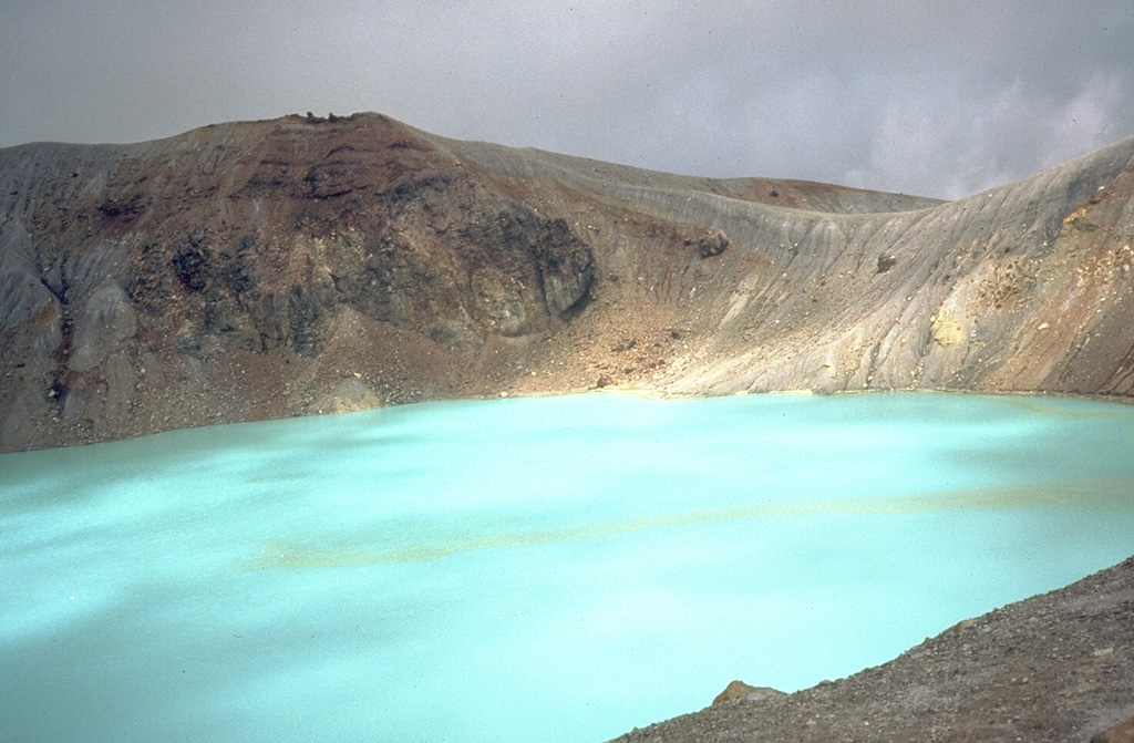
The turquoise waters of Yugama, one of three craters at the summit of Japan’s Kusatsu-Shirane volcano, are a popular tourist destination. Yellow rafts of sulfur float on the surface of the acidic lake, which prior to an eruption in 1882, was clear with forested walls. Frequent phreatic explosions have occurred from Yugama and the two other summit craters during historical time. This 1981 photo was taken from the south crater rim.
The Kusatsu-Shiranesan complex, located immediately north of Asama volcano, consists of a series of overlapping pyroclastic cones and three crater lakes. The andesitic-to-dacitic volcano was formed in three eruptive stages beginning in the early to mid-Pleistocene. The Pleistocene Oshi pyroclastic flow produced extensive welded tuffs and non-welded pumice that covers much of the E, S, and SW flanks. The latest eruptive stage began about 14,000 years ago. Historical eruptions have consisted of phreatic explosions from the acidic crater lakes or their margins. Fumaroles and hot springs that dot the flanks have strongly acidified many rivers draining from the volcano. The crater was the site of active sulfur mining for many years during the 19th and 20th centuries.
Sources: Japan Meteorological Agency (JMA) , GVP
Photo : Dick Stoiber, 1981 (Dartmouth College).
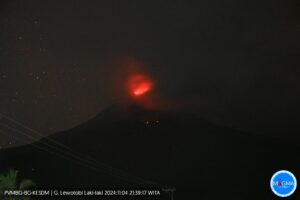
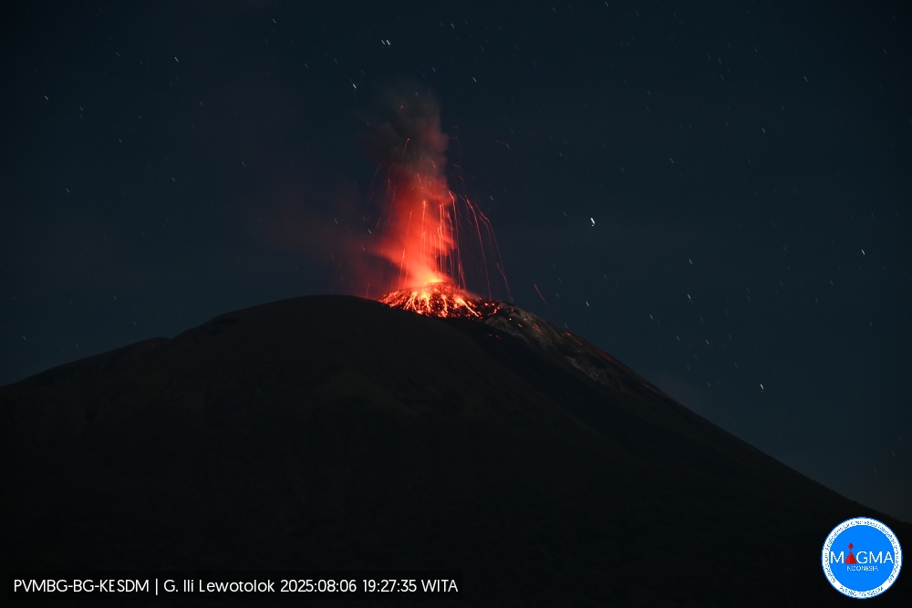
Indonesia , Ili Lewotolok :
An eruption of Mount Ili Lewotolok occurred on Wednesday, August 6, 2025, at 7:27 PM WITA. An ash column was observed about 400 m above the summit (about 1,823 m above sea level). The ash column was white to gray in color, moderate in intensity, and directed westward. This eruption was recorded by seismograph with a maximum amplitude of 36.6 mm and a duration of 55 seconds.
Seismic Observations
33 eruption earthquakes with amplitudes ranging from 5.4 to 37 mm and lasting from 40 to 51 seconds.
28 emission earthquakes with amplitudes ranging from 1.6 to 7.8 mm and lasting from 29 to 45 seconds.
Recommendations
At Activity Level III (SIAGA):
Residents living near Mount Ili Lewotolok, as well as visitors, mountaineers, and tourists, are advised to refrain from entering a 3 km radius around the activity center of Mount Ili Lewotolok. Be aware of the potential dangers of lava avalanches and pyroclastic flows originating from the southern, southeast, western, and northeast sectors of Mount Ili Lewotolok.
Source et photo : Magma Indonésie .