July 28 , 2025.
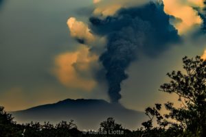
Iceland , Reykjanes Peninsula :
At the eruption site today, significant sulfur dioxide (SO₂) pollution has been measured, which is considered harmful to sensitive individuals. The Icelandic Meteorological Office’s gas dispersion forecast predicts continued NNW winds in the area, so it is likely that the pollution will persist at the eruption site and surrounding areas, such as hiking trails and viewpoints overlooking the eruption. The Environmental Agency recommendations say to reduce outdoor exertion under such conditions, and children are advised not to stay outdoors when exposed to this pollution.
There is reason to warn about the danger created by walking on newly formed lava, as people have been seen walking on new and recent lava near the Sundhnúkar crater row in recent days.
Did you know that a 10-meter-thick lava flow can take more than two years to solidify completely? Lava is an excellent insulator, so it stays hot and even molten beneath a thin crust for a long time after it has erupted. Therefore, it can be extremely dangerous to walk on new lava, as there may be only a few centimeters separating the hard lava surface from liquid lava below. This also applies to older lava flows that have erupted in recent years.
The crust on the new lava is thin and can break, so it is also inadvisable to go very close to the lava edge, as new lava tongues can flow forward without warning.
Source : IMO .
Photo : Smile Adventure
Indonesia , Ili Lewotolok :
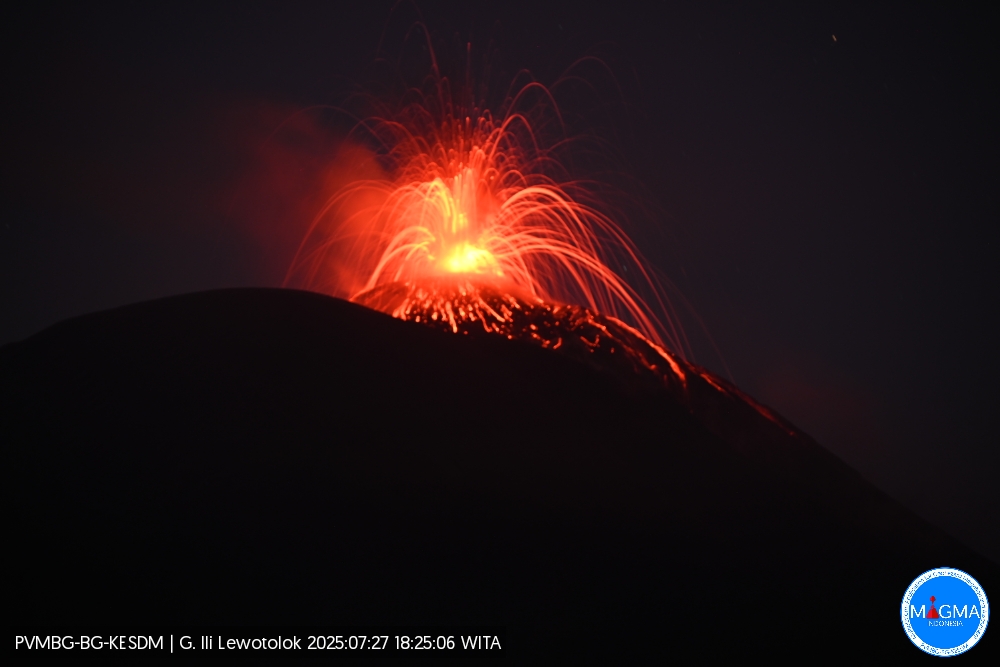
An eruption of Mount Ili Lewotolok occurred on Sunday, July 27, 2025, at 6:25 p.m. (local time). An ash column was observed about 200 m above the summit (about 1,623 m above sea level). The ash column was white to gray in color, with moderate intensity, oriented northwest. This eruption was recorded by seismograph with a maximum amplitude of 35.3 mm and a duration of 30 seconds.
Seismic Observations
40 eruption earthquakes with amplitudes ranging from 12.8 to 35 mm and durations ranging from 54 to 63 seconds.
38 emission earthquakes with amplitudes ranging from 1.2 to 7 mm and durations ranging from 23 to 43 seconds.
3 deep volcanic earthquakes with amplitudes ranging from 1.1 to 4.4 mm and durations ranging from 9 to 24 seconds.
Recommendations
At Activity Level III (SIAGA):
Residents living near Mount Ili Lewotolok, as well as visitors, climbers, and tourists, are advised to refrain from entering or carrying out activities within a 3 km radius of the activity center of Mount Ili Lewotolok. Be aware of the potential dangers of lava avalanches and pyroclastic flows originating from the southern, southeastern, western and northeastern sectors of Mount Ili Lewotolok.
Source et photo : Magma Indonésie .
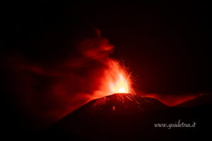
Colombia , Galeras :
San Juan de Pasto, July 22, 2025, 4:30 p.m.
Regarding the monitoring of the activity of the Galeras Volcano, the Colombian Geological Survey (SGC), an entity affiliated with the Ministry of Mines and Energy, reports that:
During the week of July 15 to 21, 2025, the main variations in the monitored parameters compared to the previous week were:
• A decrease in seismic occurrence and energy release was recorded, with seismic activity remaining low. The predominance of seismic activity associated with rock fracturing continues, accounting for 80% of all seismic events. • Most of the events were located near the volcano’s crater, at distances less than 1.0 km, at shallow depths (less than 2.2 km from its summit at 4,200 m altitude) and with low energy levels. In addition, two earthquakes were located in the area of influence of the Galeras volcano, at a maximum distance of 5.4 km from the crater and at a depth of 5.5 km.

• When weather conditions permitted, gas plumes were observed, mainly originating from the fumarole fields of El Paisita, to the north, and Las Chavas, to the west of the active cone. These plumes were white, low in height, and exhibited variable dispersion, influenced by wind direction and speed.
• Other volcanic monitoring parameters remained stable.
In view of the above, the SGC recommends closely monitoring developments through weekly bulletins and other information published through our official channels, as well as instructions from local and departmental authorities and the National Disaster Risk Management Unit (UNGRD).
Volcanic activity remains on yellow alert: active volcano with changes in the reference level of monitored parameters and other manifestations.
Source et photo : SGC.
Ecuador , Sangay :
DAILY STATUS REPORT OF SANGAY VOLCANO, Sunday, July 27, 2025.
Information Geophysical Institute – EPN.
Surface Activity Level: High, Surface Trend: No Change
Internal Activity Level: Moderate, Internal Trend: No Change
Seismicity: From July 26, 2025, 11:00 a.m. to July 27, 2025, 11:00 a.m.:
Seismicity:
Below is the count of seismic events recorded at the reference station.
Explosion (EXP): 58
Rainfall/Lahars:
Since yesterday afternoon, no rain has been recorded in the volcanic area. **Heavy rains could remobilize accumulated material, generating mud and debris flows that would cascade down the volcano’s flanks and flow into adjacent rivers**.
Emissions/Ash Column:
Over the past 24 hours, surveillance cameras and satellite images have observed several gas and ash emissions, with columns rising 600 to 1,400 meters above the crater, oriented north-northeast, north, northwest, southeast, and southwest. In this regard, the Washington VAAC has published three reports, all corresponding to emissions equal to 850 meters above the crater, oriented east-southeast, southeast, and southwest.
Gas:
The Mounts satellite system detected 6.70 tons of SO2 (sulfur dioxide), measured at 1:23 PM LT on July 26, 2025.
Other monitoring parameters:
Over the past 24 hours, the FIRMS satellite system recorded 17 thermal anomalies, while the MIROVA-SENTINEL, MIROVA-VIIRS 750, and MIROVA-VIIRS 375 systems recorded 1, 2, and 3 thermal anomalies, respectively.
Observation:
Since yesterday afternoon, the volcano has remained mostly cloudy. However, in the early hours of the day, the surveillance camera system observed incandescent material descending up to 400 meters below the crater level.
Alert level: Yellow
Source : IGEPN
Photo : Cristopher Cardenas / Volcan Sangay / FB.
La Martinique , Mount Pelée :
Weekly Report, Paris Institute of Earth Physics / Martinique Volcanological and Seismological Observatory
Saint-Pierre, July 25, 2025, at 3:15 p.m. local time (GMT-4)
Volcanic activity decreased slightly this week, with 59 earthquakes of volcanic origin observed.
Between July 18, 2025, at 4:00 p.m. (UT) and July 25, 2025, at 4:00 p.m. (UT), the OVSM recorded:
• 58 low-energy volcano-tectonic earthquakes. These earthquakes were clearly identified as originating from one of the well-known seismically active zones on Mount Pelée,
located between 1.0 and 1.4 km deep below the volcano’s summit. The shallow volcano-tectonic seismicity is associated with microfracturing within the volcanic edifice, linked to the overall reactivation of the volcano observed since late 2018.
• One deep long-period earthquake with a magnitude of Mlv = 0.7 was located at a depth of 29 km southwest of Mount Pelée. Deep long-period earthquakes contain only low frequencies and are associated with the circulation of magmatic fluids deep within the Mount Pelée volcanic system.
No earthquakes were felt by the population.
The previous week, the OVSM recorded 91 earthquakes of volcanic origin. As of July 25, 2025, and over the past four weeks, the OVSM has observed a total of 327 volcanic earthquakes, an average of 81 to 82 earthquakes per week.
During phases of volcanic reactivation in volcanoes similar to Mount Pelée, seismic activity of varying intensity and frequency is commonly observed.
For more details on observations and interpretations of volcanic activity over the longer term, refer to the OVSM’s monthly bulletins.
The alert level is currently YELLOW: vigilance.
Source : Direction de l’OVSM-IPGP.
Photo : rci.fm