July 23 , 2025 .
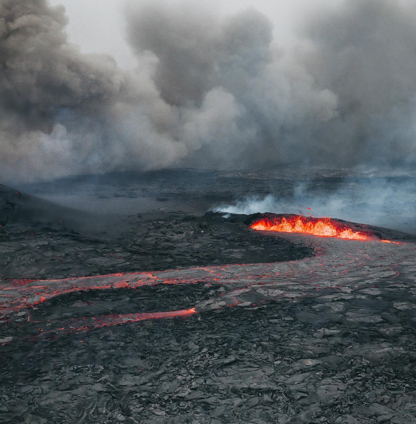
Iceland : Reykjanes Peninsula :
Eruption ongoing on the Sundhnúkur crater row
Updated 14:40, 22 July
SO₂ pollution is expected to drift eastward today, covering large parts of South and East Iceland by the evening. Tomorrow, the pollution is forecasted to spread more widely across the country.
Only one crater remains active. The northern crater activity ceased at 22:00 last night.
Ground deformation observations currently show no indication of deformation around Svartsengi
People are encouraged to monitor gas forecasts, air quality, and their own symptoms and reactions.

The hazard assessment map has been updated and is valid until July 25, unless changing conditions warrant further updates.
Eruption Status
Only one of the two previously active craters is currently erupting. Activity from the northern crater ceased around 22:00 last night. The lava continues to thicken and flow slowly eastward into Fagradal, although the advance is very gradual. Volcanic tremor is gradually decreasing with intermittent fluctuations due to crater rim build-up. Seismic activity remains low in the area.
Ground deformation observations “GPS and InSAR” currently show no indication of either uplift or subsidence in the vicinity of Svartsengi, suggesting that magma inflow and outflow to the system are presently in equilibrium and that the eruption is being sustained by magma inflow from a deeper level within the crust.
Source : IMO
Photo : Bjorn Steinbekk via FB.
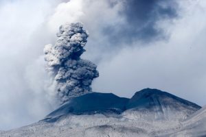
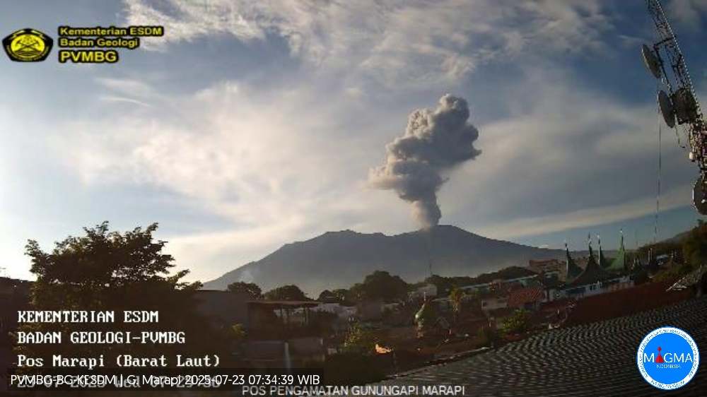
Indonesia , Marapi :
Mount Marapi erupted on Wednesday, July 23, 2025, at 7:23 a.m. (local time). An ash column was observed about 1,600 m above the summit (approximately 4,491 m above sea level). The ash column was white to gray in color, with a strong intensity directed toward the southeast. This eruption was recorded by seismograph with a maximum amplitude of 30.5 mm and a duration of 78 seconds.
VOLCANO OBSERVATORY NOTICE FOR AVIATION – VONA
Issued : July 23 , 2025
Volcano : Marapi (261140)
Current Aviation Colour Code : ORANGE
Previous Aviation Colour Code : orange
Source : Marapi Volcano Observatory
Notice Number : 2025MAR057
Volcano Location : S 0 deg 22 min 52 sec E 100 deg 28 min 23 sec
Area : West Sumatra, Indonesia
Summit Elevation : 9251 FT (2891 M)
Volcanic Activity Summary :
Eruption with volcanic ash cloud at 0023 UTC (0723 local).
Volcanic Cloud Height :
Best estimate of ash-cloud top is around 14371 FT (4491 M) above sea level or 5120 FT (1600 M) above summit. May be higher than what can be observed clearly. Source of height data: ground observer.
Other Volcanic Cloud Information :
Ash cloud moving to southeast. Volcanic ash is observed to be white to gray. The intensity of volcanic ash is observed to be thick.
Remarks :
Eruption recorded on seismogram with maximum amplitude 30.5 mm and maximum duration 78 second.
Source et photo : Magma Indonésie .
Italy / Sicily , Etna :
WEEKLY BULLETIN, July 14-20, 2025. (Publication date: July 22, 2025)
ACTIVITY STATUS SUMMARY
Based on monitoring data, the following points are highlighted:
1) VOLCANOLOGICAL OBSERVATIONS: Variable rate degassing activity in the summit craters.
2) SEISMOLOGICAL OBSERVATIONS: Absence of seismic fracturing with Ml >= 2.0. Tremor amplitude generally low.
3) INFRASOUND: Moderate infrasound activity.
4) GROUND DEFORMATION: No significant changes are reported in the time series of ground deformation monitoring networks. 5) GEOCHEMISTRY: SO2 flux at low levels
Soil CO2 flux (EtnaGas Network): medium to low values
Dissolved CO2 in groundwater (EtnaWater Network): no update.
Helium isotope ratio at peripheral sites: no update; the latest data from June 25 showed medium to high values.
6) SATELLITE OBSERVATIONS: Thermal activity observed by satellite in the summit area was generally low.
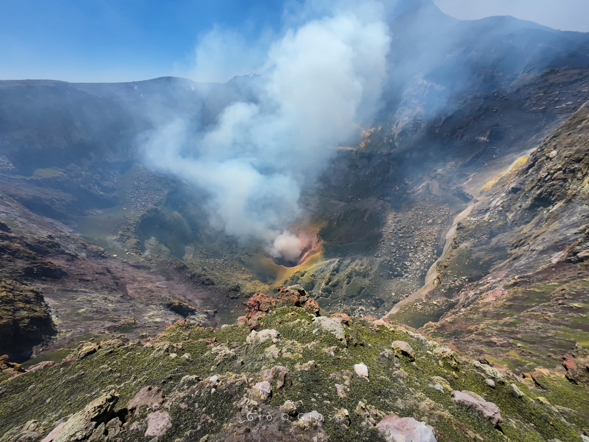
VOLCANOLOGICAL OBSERVATIONS
During the observation period in question, Mount Etna’s volcanic activity was monitored through the analysis of images from the INGV surveillance camera network (Osservatorio Etneo
INGV-OE). During the week of observation, the activity of the summit craters remained essentially the same as that described in the previous week’s bulletin: the summit craters were characterized by variable degassing at each crater.
The Northeast Crater (CNE) is experiencing intense degassing generated by a vent located at the crater floor. The other craters, however, exhibit less intense diffuse degassing, mainly attributable to various fumarolic systems, while the Bocca Nuova Crater (BN) exhibits degassing primarily generated by the BN1 pit crater.
Source : INGV
Photo : Gio Giusa
Italy , Stromboli :
WEEKLY BULLETIN, July 14-20, 2025. (Publication date: July 22, 2025)
ACTIVITY STATUS SUMMARY
Based on monitoring data, the following points are highlighted:
1) VOLCANOLOGICAL OBSERVATIONS: Ordinary, low-frequency eruptive activity occurred in the North and South-Central crater areas. The average total frequency was 6.2 events/hour, with low intensity and medium-intensity episodes in the North area and low intensity in the South-Central area. Eruptive activity has been decreasing since the second half of June.
2) SEISMOLOGY: The monitored seismological parameters show no significant changes.
3) GROUND DEFORMATION: No significant changes were detected.
4) GEOCHEMISTRY: Low-level SO2 fluxes. Soil CO2 fluxes in the Pizzo area (STR02) are medium to high.
C/S ratio in the plume: medium values.
Helium isotope ratio (R/Ra) dissolved in the thermal aquifer: high values.
Soil CO2 fluxes in the Scari area: high values.
5) SATELLITE OBSERVATIONS: Thermal activity observed by satellite in the summit area was generally low.
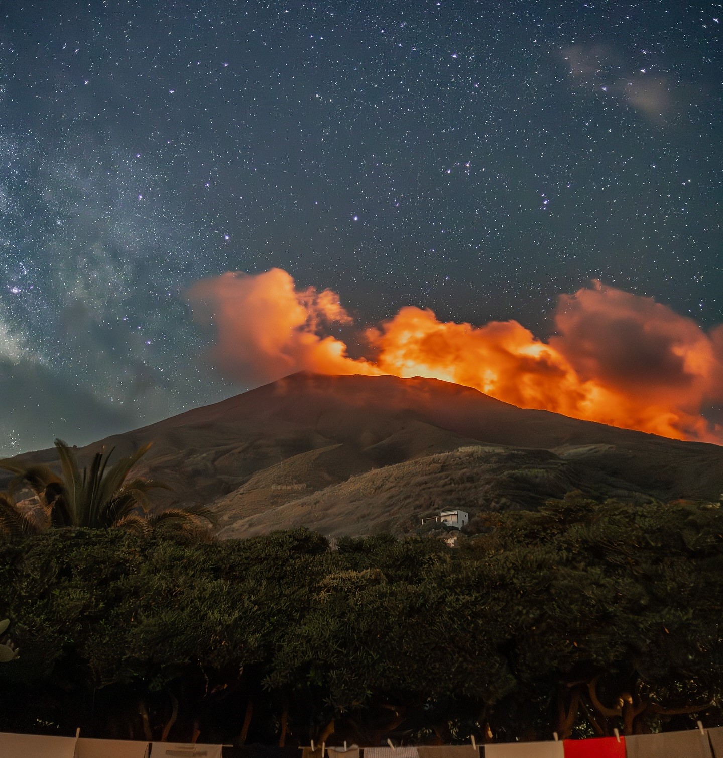
VOLCANOLOGICAL OBSERVATIONS
During the observation period, Stromboli’s eruptive activity was characterized by analyzing images recorded by the INGV-OE surveillance cameras located at an altitude of 190 m (SCT-SCV) and at Punta dei Corvi (SPCT). The explosive activity was mainly produced by four eruptive vents located in the North Crater area and by at least two vents located in the Central-South Crater area.
Observations of explosive activity captured by surveillance cameras
The eruptive activity observed in the North Crater area (N) was produced by four active vents, with eruptive products consisting mainly of coarse materials (bombs and lapilli). The explosions were of low intensity (the eruptive products reached a height of less than 80 m) and, at times, of medium intensity (the height of the products varied between 80 and 150 m). The average explosion frequency was approximately 5.3 events per hour.
In the Centre-Sud (CS) area, explosive activity was modest, with the explosions characterized by the emission of low-intensity fine particles. The average explosion frequency was approximately 1 event per hour.
Source : INGV
Photo : Stromboli stati d’animo / Sebastiano Cannavo.
Chile , Planchon-Peteroa :
Seismology
The seismological activity during this period was characterized by:
85 volcano-tectonic (VT) earthquakes, associated with rock fracturing. The highest-energy earthquake, with a local magnitude (LM) of 2.6, occurred 7.1 km northeast of the volcanic edifice, at a depth of 4.4 km.
2,624 LP (Long Period) earthquakes, associated with fluid dynamics within the volcanic system. The magnitude of the largest earthquake, evaluated using the reduced displacement (RD) parameter, was 25 cm².
438 TR (Tremor) earthquakes, associated with sustained fluid dynamics within the volcanic system. The magnitude of the largest earthquake, evaluated using the reduced displacement (RD) parameter, was 9 cm².
Satellite Thermal Anomalies
During the period, no thermal anomalies were recorded in the area associated with the volcanic system, according to MODIS and VIIRS (750 m) data processed by the Mid-Infrared Volcanic Activity Observation Center (MIROVA), as well as LandSat 8 data and analytical processing of Sentinel 2-L2A satellite images, using a combination of false-color bands. VIIRS (375 m), provided by MIROVA, recorded maximum values below 0.3 MW during the period assessed, which is considered a very low radiative power anomaly.
Geodesy
According to data obtained by the Global Navigation Satellite System (GNSS) network, which measures the volcano’s surface deformation, a slight variation of 0.5 cm/month was observed in the horizontal component over the last month. No variation in the vertical component was observed in the medium or long term, which could indicate a moderate response to a surface process, with no signs of activity at depth. Furthermore, radar interferometry results are not available due to a lack of coherence caused by snow cover.
Surveillance Cameras
Images provided by fixed cameras installed near the volcanic system recorded passive degassing from the summit of Peteroa Volcano, with a column height of approximately 100 m above the crater level. No other variations associated with surface activity were observed.
The Planchón-Peteroa volcanic complex has shown a significant change in its internal activity since July 10, evidenced by an increase in seismicity associated with fluid dynamics (LP-type seismic events and tremors). The characteristics and location of these events suggest the activation of hydrothermal systems driven by heat transfer from deep magmatic fluids. Although other monitoring parameters remain stable and surface activity is limited, this type of behavior preceded previous eruptive cycles characterized by ash emissions.
In light of the above, it is concluded that the volcanic system is showing signs of activity above its baseline threshold. Therefore, the technical volcanic alert has been modified to:
YELLOW TECHNICAL ALERT: Changes in the behavior of volcanic activity.
Source et photo : Ingeominas.