July 17 , 2025.
Iceland , Reykjanes Peninsula :
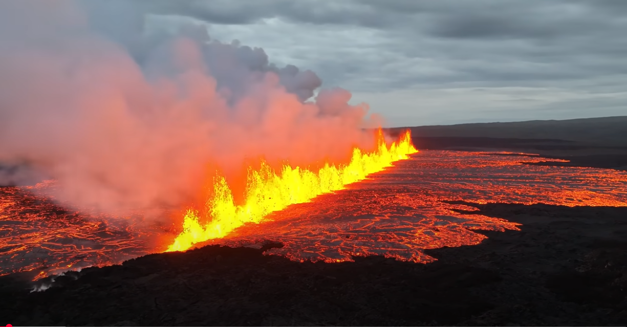
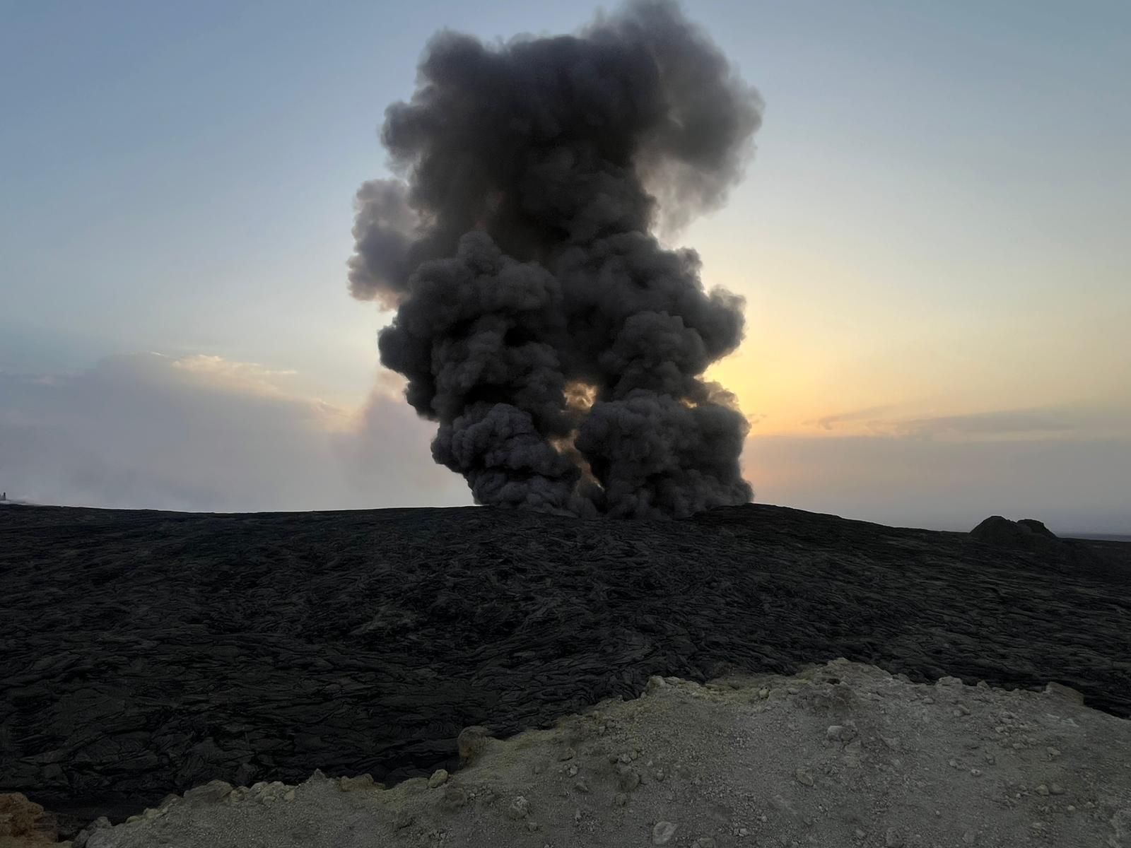
An eruption has started on Sundhnúksgígaröð crater row , July 16 , 2025
Updated at 17:30
The Icelandic Meteorological Office has issued an updated hazard assessment map, valid until 15:00 on 18 July unless activity changes. The alert level for the volcanic system remains at the highest level, 3.
The hazard assessment is based on recent observations and shows the following:
The eruptive fissure has lengthened and now extends farther north than previous fissures since December 2023.
Lava flow continues but has decreased in intensity.
Most of the lava is accumulating east of the fissure and is likely to fill depressions in the area.
Seismic activity has decreased significantly, now measuring only a few small earthquakes per hour.
Gas emissions and wildfires continue to contribute to pollution.
Volcanic tremor and activity
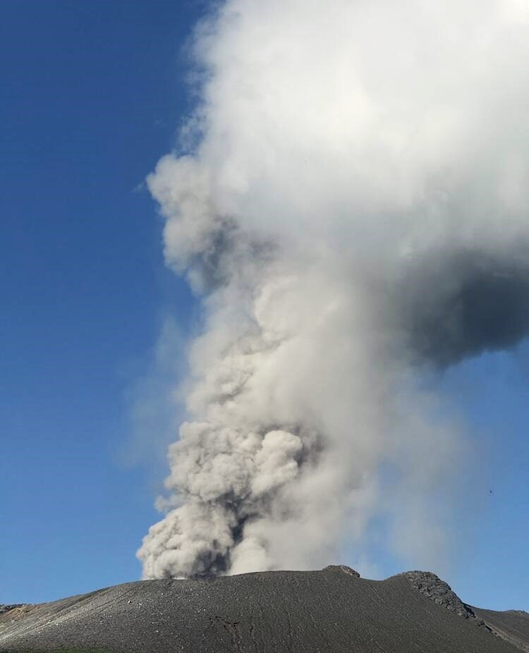
The eruption at Sundhnúksgígaröð continues, but measurements show a decline in its intensity since this morning.
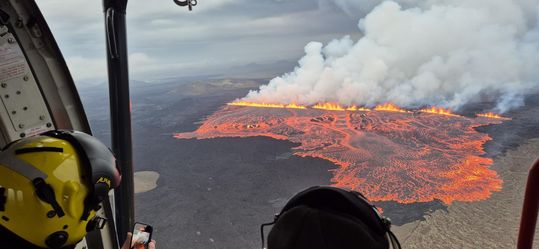
The eruption seen from the Coast Guard helicopter during a surveillance flight.
The Icelandic Meteorological Office (IMO) reported that an eruption began on 16 July in an area NE of Stóra Skógfell, along the Sundhnúkur crater row, within the Reykjanes volcanic system. IMO issued a Volcano Observatory Notices for Aviation (VONA) at 01h06, raising the Aviation Color Code to Red (the highest level on a four-color scale), after monitoring data indicated a dike intrusion. An intense seismic swarm that began at 01h20 was located between Stóra-Skógfell and Sýlingarfell, and deformation data indicated that the dike was propagating towards the S and rising to the surface. A fissure eruption began at 03h56. The eruption was observed in webcams along with both drone and helicopter overflights. Lava fountains rose along the fissure, but no ash was present in the air; the Aviation Color Code was lowered to Orange at 04h35.
By 05h05 the fissure was 700-1,000 m long and opening towards the N. Lava fountains continued to rise along the fissure and lava flows traveled mostly SE. Seismicity had decreased by 08h45. Lava flows advanced W and to a greater extent to the E. Pele’s hair drifted downwind. High levels of volcanic gases were measured in Reykjanesbær prompting authorities to advise residents to stay indoors. By noon two fissures were erupting; the larger fissure at the Sundhnúkur crater row was about 2.4 km long, and a smaller fissure, about 500 m long, had opened W of Fagradalsfjall.
Sources: Icelandic Meteorological Office (IMO), GVP.
Photos : The Icelandic Met Office/Halldór Björnsson , Afar TV ( capture d’écran).
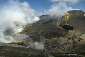
Ethiopia , Erta Ale :
Eruptive activity at Erta Ale continued during July based on satellite data and field observations. Small thermal anomalies at both the N and S pit craters were visible in periodic satellite image views on 1, 6, 8, and 11 July. On 15 July a dense black plume rising from an unstated area was filmed by a local observer and was thought to have originated from a collapse of a portion of crust covering a lava lake. A post on social media showed pictures of the plumes and stated that the plumes sank to the ground and spread out over an area of 15 km. Plumes were visible on 16 July.
The Erta Ale basaltic shield volcano in Ethiopia has a 50-km-wide edifice that rises more than 600 m from below sea level in the Danakil depression. The volcano includes a 0.7 x 1.6 km summit crater hosting steep-sided pit craters. Another larger 1.8 x 3.1 km wide depression elongated parallel to the trend of the Erta Ale range is located SE of the summit and is bounded by curvilinear fault scarps on the SE side. Basaltic lava flows from these fissures have poured into the caldera and locally overflowed its rim. The summit caldera usually also holds at least one long-term lava lake that has been active since at least 1967, and possibly since 1906. Recent fissure eruptions have occurred on the N flank.
Sources: Copernicus, Sputnik, Adal state , GVP.
Photo : Seifegebreil Shifferaw .
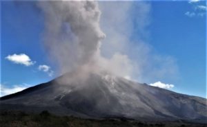
Japan , Shinmoedake :
The Japan Meteorological Agency (JMA) reported that eruptive activity continued at Shinmoedake (Shinmoe peak, a stratovolcano of the Kirishimayama volcano group) during 10-16 July. The number of volcanic earthquakes with epicenters directly beneath Shinmoedake had been fluctuating since late October 2024; volcanic tremor was occasionally detected. Eruptive activity occurred intermittently with grayish-white plumes rising as high as 400 m above the crater rim. On 15 July sulfur dioxide emissions were high, averaging 1,600 tons per day. The Alert Level remained at 3 (on a 5-level scale) and the public was warned to exercise caution within 3 km from Shinmoedake Crater.
Kirishimayama is a large group of more than 20 Quaternary volcanoes located north of Kagoshima Bay. The late-Pleistocene to Holocene dominantly andesitic group consists of stratovolcanoes, pyroclastic cones, maars, and underlying shield volcanoes located over an area of 20 x 30 km. The larger stratovolcanoes are scattered throughout the field, with the centrally located Karakunidake being the highest. Onamiike and Miike, the two largest maars, are located SW of Karakunidake and at its far eastern end, respectively. Holocene eruptions have been concentrated along an E-W line of vents from Miike to Ohachi, and at Shinmoedake to the NE. Frequent small-to-moderate explosive eruptions have been recorded since the 8th century.
Sources: Japan Meteorological Agency (JMA), GVP.
Photo : GSJ_JP . via Sherine France / FB.
Chile , Laguna del Maule :
Special Report on Volcanic Activity (REAV), Maule Regions, Laguna del Maule Volcanic Complex, July 16, 2025, 4:59 a.m. local time (Continental Chile)
The National Geology and Mining Service of Chile (Sernageomin) announces the following preliminary information, obtained using the monitoring equipment of the National Volcanic Monitoring Network (RNVV), processed and analyzed at the Southern Andean Volcano Observatory (OVDAS):
On Wednesday, July 16, 2025, at 4:57 a.m. (08:57 UTC), monitoring stations installed near the Laguna del Maule volcanic complex recorded an increase in the occurrence of volcano-tectonic earthquakes (associated with rock fracturing within the volcanic system), reaching a total of 100 earthquakes in the last three hours, characterizing this seismic episode as a swarm of earthquakes.
The characteristics of the highest-energy earthquake after its analysis are as follows:
TIME OF ORIGIN: 04:35 local time (08:35 UTC)
LATITUDE: 36.080° S
LONGITUDE: 70.486° W
DEPTH: 7.9 km
LOCAL MAGNITUDE: 3.1 (ML)
Observation:
At the time of this report, volcano-tectonic events continue to be recorded at the Laguna del Maule volcanic complex, but at lower magnitudes.
The technical volcanic alert remains at GREEN.
Source : Sernageomin
Photo : auteur inconnu
Colombia , Chiles / Cerro Negro :
San Juan de Pasto, July 15, 2025, 4:45 p.m.
According to monitoring of the activity of the Chiles-Cerro Negro Volcanic Complex (CVCCN), the Colombian Geological Survey (SGC), an entity affiliated with the Ministry of Mines and Energy, reports that:
From July 8 to 14, 2025, the main variations in the monitored parameters compared to the previous week were:
● An increase in seismic occurrence and energy release was recorded, manifested by a series of earthquakes associated with rock fractures, which began on July 9, with a peak in activity on July 10, 11, and 12.
Compared to other periods of increased seismic activity, very few earthquakes related to fluid movements were recorded during this period.
● Seismic activity was concentrated at the summit and collapse zone of Chiles Volcano, at depths between 2 and 5 km from its summit (4,700 m above sea level) and at distances of less than 1.5 km. Three high-intensity events were observed: the first, recorded on July 11 at 12:34 p.m., with a magnitude of 3.7; the other two, recorded on July 12 at 1:55 p.m. and 2:20 p.m., with magnitudes of 3.3 and 3.0, respectively.
The last of these earthquakes was reported as being felt in the epicentral area.
● Satellite sensors and ground stations measuring crustal deformation continue to show inflation in the volcanic area. Based on the assessment and correlation of monitored parameters, the SGC recommends closely monitoring developments through weekly bulletins and other information published through our official channels, as well as instructions from local and departmental authorities and the National Disaster Risk Management Unit (UNGRD).
Volcanic activity remains on yellow alert: active volcano with changes in the baseline behavior of monitored parameters and other manifestations.
Source et photo : SGC.