July 3 , 2025 .
Japan , Shinmoedake :
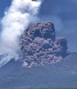
The Japan Meteorological Agency (JMA) reported that eruptive activity continued at Shinmoedake (Shinmoe peak, a stratovolcano of the Kirishimayama volcano group) at least through 30 June. After the eruption on 22 June no further eruptive events were detected in monitoring data during 23-24 June, and weather clouds often obscured views. On 24 June white plumes rose more than 400 m above the crater rim and at most 100 m above a fissure on the W flank based on webcam images. Tilt data from a station 3 km SE indicated inflation on the NW flank during 23-25 June, though minor inflation had been detected since March. The number of volcanic earthquakes with epicenters directly beneath Shinmoedake had been fluctuating since late October 2024, though the rates were very high with more than 600 events recorded during 23-24 June, more than 400 events during 24-25 June, and more than 300 events during 25-26 June. Volcanic tremor was also periodically detected. On 25 June sulfur dioxide emissions were high, averaging 2,100 tons per day.
Weather clouds obscured views during the morning of 26 June, though at around 07h58 a small amount of ashfall was reported at Takaharu Town (12 km E) in Miyazaki Prefecture. At 12h50 white plumes were visible rising 1 km above the crater rim and drifting E, and by 15h07 they were drifting SE. Grayish white plumes continuously rose as high as 1.6 km above the crater rim, drifting S and SE, from 10h25 on 27 June until at least 15h00 on 1 July. Minor ashfall was reported at the Miyazaki Local Meteorological Observatory (Miyazaki City, 50 km E) during 26-27 June, and a relatively large amount of ash fell in both Kobayashi City (13 km NE) and Kirishima City (21 km SW) during 09h00-23h00 on 28 June. During a 28 June field survey, observers noted that the plumes were rising from a row of N-S-trending craters located on the NE part of the crater floor. Ash deposits were visible on the N flank and the temperature of those deposits was higher than surrounding areas. A geothermal area near a fissure on the W flank was enlarged compared to 7 May observations. The Alert Level remained at 3 (on a 5-level scale) and the public was warned to exercise caution within 3 km from Shinmoedake Crater.
Sources : Agence météorologique japonaise (JMA) , GVP.
Photo : Capture d’écran du Groupe vidéo du journal Mainichi
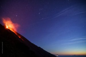
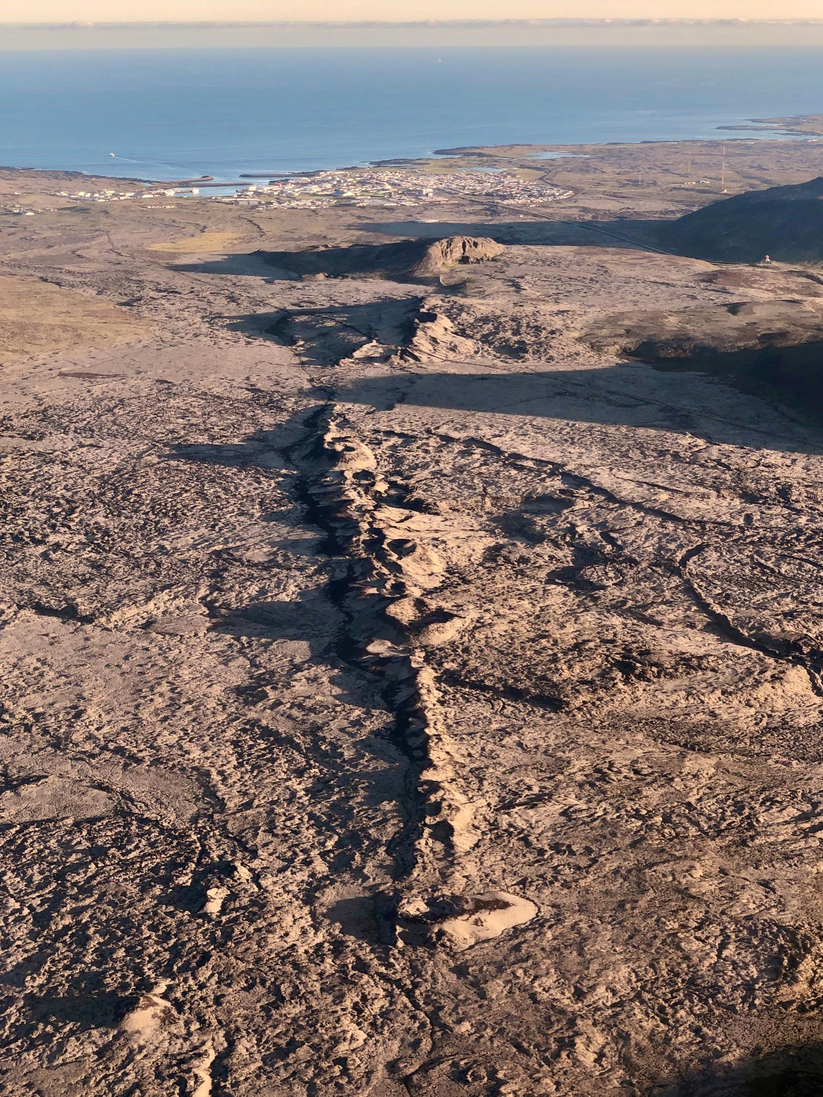
Iceland , Reykjanes Peninsula :
Continued Uplift in Svartsengi
Update 1. July
Uplift and seismic activity continue in the Svartsengi area. Activity levels have remained stable in recent weeks.
Magma continues to accumulate in the reservoir beneath Svartsengi.
No significant changes have been observed that would warrant a revision of the current hazard assessment.
If magma accumulation continues, the likelihood of a magma intrusion or volcanic eruption will increase.
The Icelandic Meteorological Office’s hazard map remains valid until 15 July 2025, unless conditions change.
Land uplift and earthquake activity are ongoing in the Svartsengi area, with stable activity levels in recent weeks. On average, about 10 micro-earthquakes are detected per day, most of them located north of Grindavík and south of Stóra Skógfell.
No substantial changes have been detected in key measurements that would prompt a reassessment of the hazard level. However, continued magma accumulation could increase the likelihood of a magma intrusion or volcanic eruption in the coming autumn.
Source : IMO.
Photo : Siggi Anton
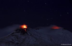
Italy , Vulcano :
MONTHLY BULLETIN, REFERENCE MONTH JUNE 2025, (publication date: July 1, 2025)
ACTIVITY STATUS SUMMARY
Monitoring data highlights:
1) Crater fumarole temperature: Crater fumarole temperature values recorded in June are decreasing.
2) CO2 flux in the crater area: CO2 flux data continuously recorded by the VSCS station indicate average to low values.
3) SO2 flux in the crater area: SO2 flux is at an average level.
4) Fumarolic gas geochemistry: CO2 concentrations in the crater fumaroles are between 9 and 10 mol%, a decrease compared to the values measured during the summer of 2024.
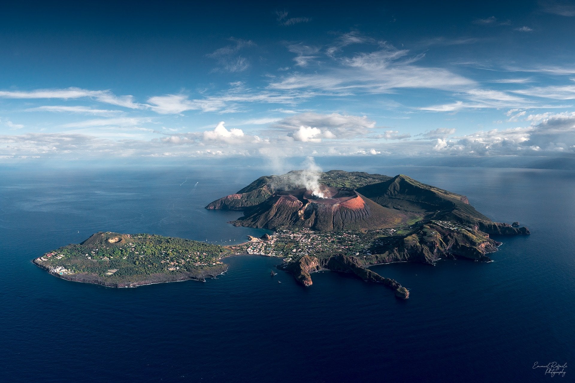
5) CO2 fluxes at the base of the La Fossa cone and in the Vulcano Porto area: Continuously recorded CO2 fluxes at the base of the cone show stable values compared to their respective background levels, and no significant variations are observed.
6) Thermal aquifer geochemistry: In the C. Sicilia well, temperatures and conductivity are constant. In the Bambara well, no significant variations are observed.
7) Local seismicity: Low occurrence rate of local seismicity.
8) Regional seismicity: Low seismic activity due to fracturing.
9) Deformation – GNSS: No significant changes at high-frequency GNSS stations.
10) Deformation – Inclinometer: No significant changes in the inclinometer data.
11) Gravimetry: No significant changes were recorded.
Notes:
A dormant volcano, without eruptive activity, with gas emissions from fumaroles within the crater and areas outside the crater, possibly accompanied by: diffusion of toxic gases in the fumarole emission areas; accumulations of gases (particularly CO2 and H2S) near emission areas at sea, in downwind areas, at low altitudes, or in enclosed areas; mud and debris flows or flooding triggered by intense rainfall along the slopes of the La Fossa cone.
Source : INGV.
Photo : Emanuel Raffaele Photography.
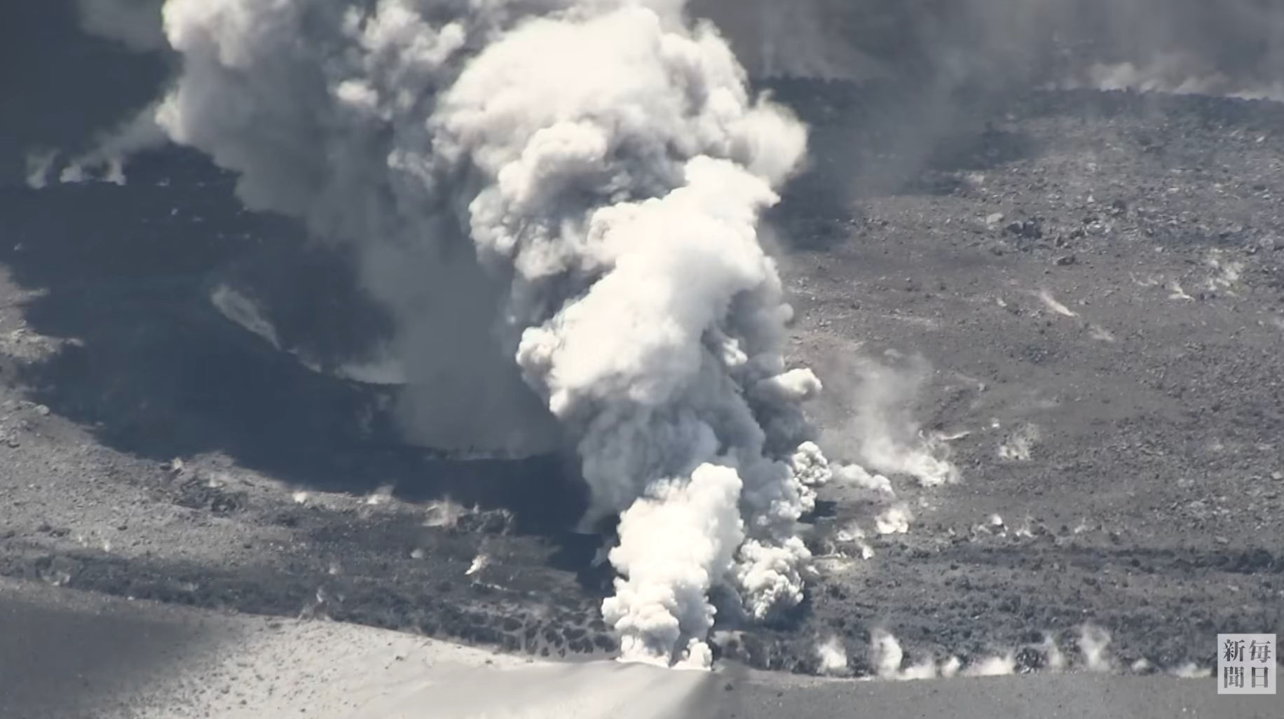
Indonesia , Ili Lewotolok :
SPECIAL REPORT ON THE INCREASE IN THE ACTIVITY LEVEL OF ILI LEWOTOLOK VOLCANO FROM LEVEL II (WASPADA) TO LEVEL III (SIAGA) ON JULY 2, 2025 AT 8:00 PM WITA.
Eruptive activity at Mount Ili Lewotolok, in the East Nusa Tenggara, has increased since June 27, 2025, and has intensified to date. This increase is marked by the rise of the eruptive column, reaching 1,200 meters above the summit, and by the ejection of incandescent material in all directions, with the maximum ejection distance reaching approximately 1,500 meters to the north and east-northeast. The ejection of incandescent material caused vegetation fires on the northern and northeastern slopes of Mount Ili Lewotolok. The eruption was also accompanied by weak to strong rumbling noises.
Seismic data for the period from June 16 to July 2, 2025 (until 8:00 PM WITA) recorded 2,482 eruption earthquakes, 4 collapse earthquakes, 3,088 emission earthquakes, 11 harmonic tremors, 16 nonharmonic tremors, 3 hybrid volcanic earthquakes, 8 shallow volcanic earthquakes, 2 deep volcanic earthquakes, 2 local tectonic earthquakes, and 16 distant tectonic earthquakes.
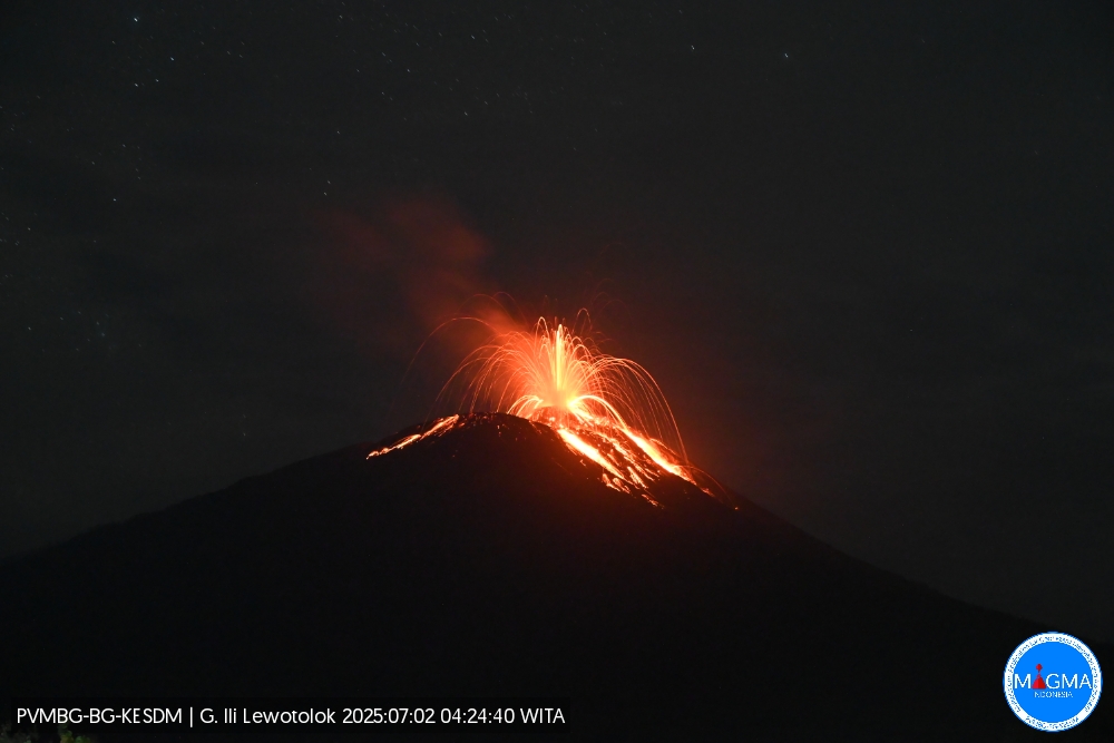
An eruption of Mount Ili Lewotolok occurred on Wednesday, July 2, 2025, at 4:26 a.m. (local time). The observed ash column was ± 500 m above the summit (± 1,923 m above sea level). The ash column was gray and of strong intensity, oriented toward the west and northwest. This eruption was recorded by a seismograph with a maximum amplitude of 40 mm and a duration of 26 seconds.
Visually, the volcano is clearly visible until it is covered by fog. White, thin to thick smoke was observed in the crater, ranging from 10 to 600 meters above the summit. The height of the observed eruptive column ranged from 100 to 1,200 meters above the summit, and was white, gray, to black.
Based on visual and instrumental monitoring data, the activity level of Mount Ili Lewotolok has been increased from Level II (WASPADA) to Level III (SIAGA) as of 20:00 (local time) on July 2, 2025. The following recommendations are issued:
Residents living near Mount Ili Lewotolok, as well as visitors, climbers, and tourists, are urged not to enter or carry out any activities within a 3 km radius of the activity center of Mount Ili Lewotolok. Be aware of the potential risk of lava avalanches and hot clouds in the southern and southeast, western, and northeast sectors of Mount Ili Lewotolok. The public is advised not to panic if rumbling noises are heard from the crater of Mount Ili Lewotolok, as this noise is characteristic of volcanic activity during an eruption phase. Loud noise can cause strong vibrations in several parts of the building, including windows and glass doors.
Local authorities and the community routinely collaborate with the Ili Lewotolok Mountain Observation Post in Laranwutun Village, Ile Ape District, the Volcanology and Geological Disaster Mitigation Center, and the Bandung Geological Agency to obtain information on the activities of Ili Lewotolok Mountain.
Source et photo : PVMBG.
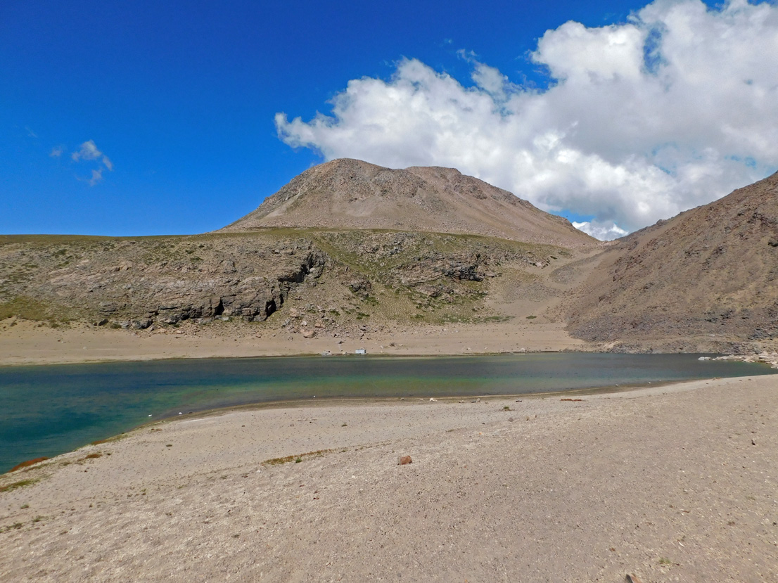
Chile , Laguna del Maule :
Special Report on Volcanic Activity (REAV), Maule Regions, Laguna del Maule Volcanic Complex, July 2, 2025, 5:10 p.m. local time (Continental Chile)
The National Geology and Mining Service of Chile (SERNAGEOMIN) announces the following preliminary information, obtained using the monitoring equipment of the National Volcanic Monitoring Network (RNVV), processed and analyzed at the Southern Andean Volcano Observatory (OVDAS):
On Wednesday, July 2, 2025, at 1:40 p.m. (5:40 p.m. UTC), monitoring stations installed near the Laguna del Maule volcanic complex recorded an increase in the occurrence of volcano-tectonic earthquakes (associated with rock fracturing within the volcanic system), reaching a total of 115 earthquakes in the last few hours, characterizing this episode. seismic like a swarm of earthquakes.
The characteristics of the highest-energy earthquake after its analysis are as follows:
TIME OF ORIGIN: 3:35 PM local time (7:35 PM UTC)
LATITUDE: 36.063°S
LONGITUDE: 70.464°W
DEPTH: 6.1 km
LOCAL MAGNITUDE: 1.8 (ML)
Observation:
At the time of this report, seismic events with similar characteristics but lower energy are still being recorded.
The Volcanic Technical Alert remains at GREEN.
Source : Sernageomin
Photo : Álvaro Vivanco , Photo prise au Sud-Ouest de la lagune de Maule.