June 29 , 2025.
Hawaii , Kilauea :
HVO/USGS Volcanic Activity Notice
Current Volcano Alert Level: WATCH
Current Aviation Color Code: ORANGE
Issued: Saturday, June 28, 2025, 8:50 AM HST
Source: Hawaiian Volcano Observatory
Notice Number: 2025/H299
Location: N 19 deg 25 min W 155 deg 17 min
Elevation: 4091 ft (1247 m)
Area: Hawaii
Volcanic Activity Summary:
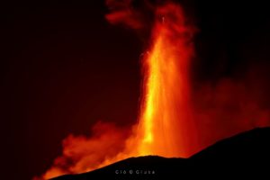
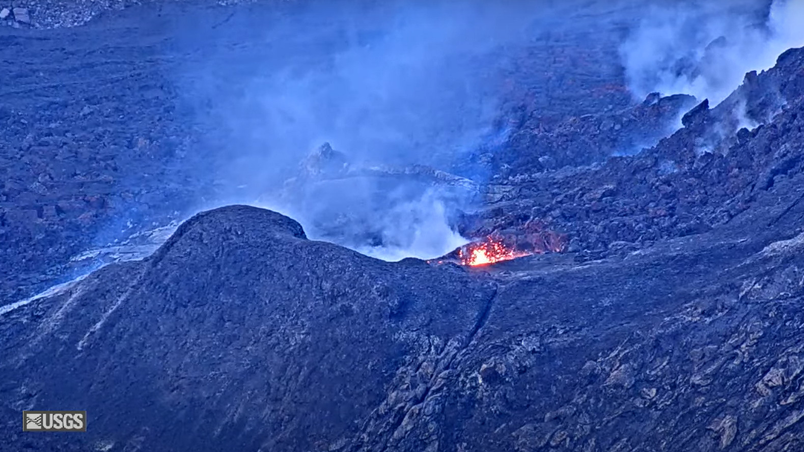
Precursory low-level activity for episode 27 of the ongoing Halemaʻumaʻu eruption began around 7:27 a.m. HST on June 28, currently consisting of intermittent lava overflows from the north vent. Sustained lava fountaining is likely to begin on June 29 or 30 (tomorrow or Monday) based on the current rate of summmit inflation, but could begin sooner if precursory activity escalates. According to the National Weather Service, winds are forecast to blow from the north-northeast to east directions within that timeframe.
In recent episodes of the ongoing eruption within Halemaʻumaʻu, low-level precursory activity has lasted from a few hours to a few days. This activity can include spatter from the north and/or south vents, small dome fountains, and lava overflowing from one or both vents.
At the start of previous episodes, precursory activity has rapidly escalated into sustained high fountaining over minutes to tens of minutes. During previous episodes, fountains reached heights of more than 1,000 feet (305 meters) and the eruptive plume reached heights of up to 20,000 feet (6,000 meters) above ground level soon after sustained fountaining began.
The tiltmeter at Uēkahuna (UWD) has recorded 15.5 microradians of inflationary tilt since the end of the last episode, during which it recorded 18.5 microradians of deflationary tilt. Low level seismic tremor continues beneath Halemaʻumaʻu crater.
Most episodes of Halemaʻumaʻu lava fountaining since December 23, 2024, have continued for around a day or less and have been separated by pauses in eruptive activity lasting generally at least several days.
No changes have been detected in the East Rift Zone or Southwest Rift Zone. A VAN/VONA will be issued when sustained lava fountaining begins, marking the start of episode 27, or earlier if the situation warrants a further update.
Source : HVO.
Photo : USGS
Japan , Shinmoedake :
The Meteorological Agency on Sunday raised the volcanic alert for Shinmoedake in the Kyushu region to Level 3 from Level 2.
The agency warned that large volcanic rocks could reach areas within 4 kilometers of the crater of the volcano, which is located between Miyazaki and Kagoshima prefectures.
Level 3 urges restrictions on entry to the volcano, while Level 2 advises people to avoid approaching areas around the crater.
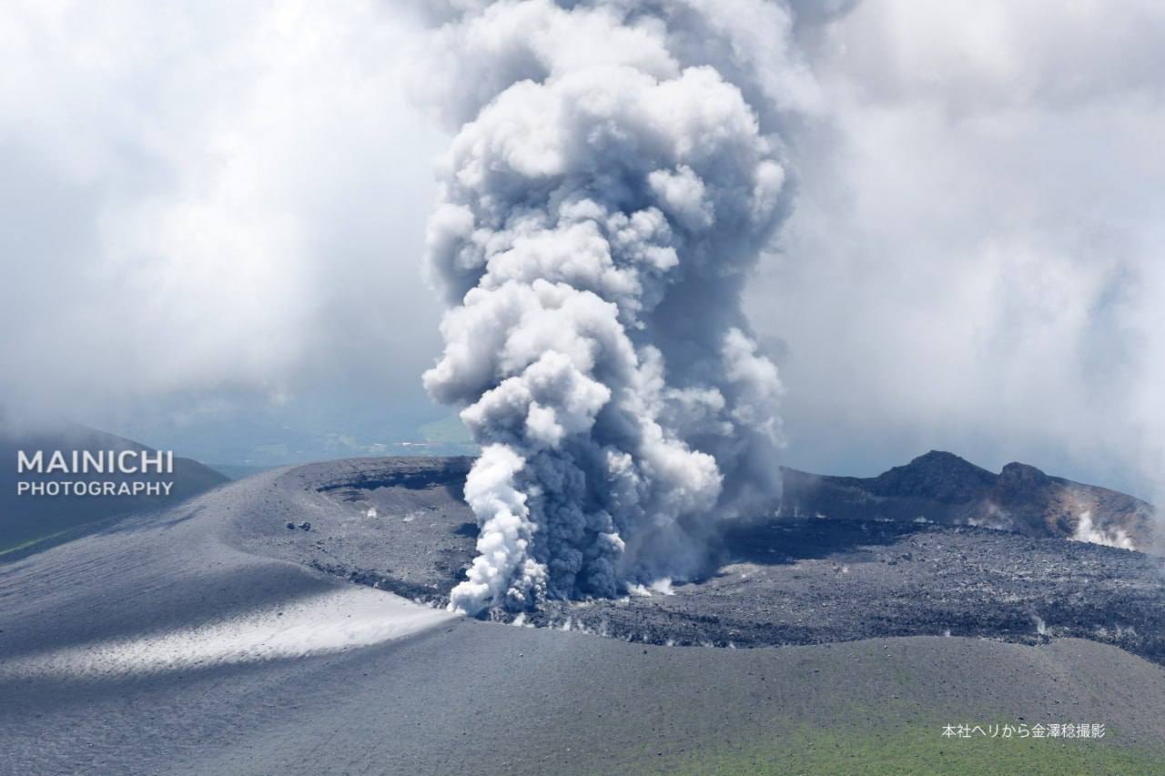
At Shinmoedake, volcanic earthquakes have increased since around Friday, and changes believed to be the swelling of the mountain have also been confirmed, according to the agency.
The alert for Shinmoedake was raised to Level 2 on Dec. 12 last year from Level 1, which warns of a possible increase in volcanic activity.
Sources : Japan Times .
Photo : Mainichi .
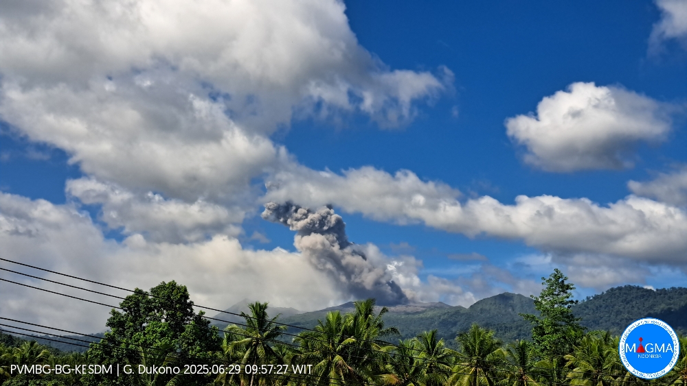
Indonesia , Dukono :
Mount Dukono erupted on Sunday, June 29, 2025, at 10:43 a.m. (local time). The observed ash column was ± 1,200 m above the summit (± 2,287 m above sea level). The ash column was white to gray, with a strong intensity, oriented northeast. At the time of this report, the eruption was still ongoing.
Seismicity Observation:
236 eruption earthquakes with an amplitude of 6 to 34 mm and a duration of 32.73 to 87.86 seconds.
4 distant tectonic earthquakes with an amplitude of 27 to 34 mm and a duration of 89.69 to 169.41 seconds.
1 continuous tremor with an amplitude of 2 to 5 mm, with a dominant value of 3 mm.
Recommendation
(1) Residents of the vicinity of Mount Dukono and visitors/tourists should not engage in activities, climb, or approach the Malupang Warirang crater within a 4 km radius. (2) Since volcanic ash eruptions occur periodically and the distribution of ash follows the direction and speed of the wind, so the area where the ash lands is not constant, people around Mount Dukono are recommended to always carry masks/nose and mouth covers to use when needed to avoid the threat of volcanic ash to the respiratory system.
Source et photo : Magma Indonésie .
Chile , Laguna del Maule :
Special Report on Volcanic Activity (REAV), Maule Regions, Laguna del Maule Volcanic Complex, June 28, 2025, 10:05 a.m. local time (Continental Chile)
The National Geology and Mining Service of Chile (Sernageomin) announces the following preliminary information, obtained using the monitoring equipment of the National Volcanic Monitoring Network (RNVV), processed and analyzed at the Southern Andean Volcano Observatory (OVDAS):
On Saturday, June 28, 2025, at 11:50 a.m. (15:50 UTC), monitoring stations installed near the Laguna del Maule volcanic complex recorded an increase in the occurrence of volcano-tectonic earthquakes (associated with rock fracturing within the volcanic system), reaching a total of 100 earthquakes in the last few hours, characterizing this episode. seismic like a swarm of earthquakes.

The characteristics of the highest-energy earthquake after its analysis are as follows:
TIME OF ORIGIN: 11:23 local time (15:23 UTC)
LATITUDE: 36.102°S
LONGITUDE: 70.561°W
DEPTH: 6.9 km
LOCAL MAGNITUDE: 1.6 (ML)
Observation:
At the time of this report, seismic events with similar characteristics but lower energy are still being recorded.
The Volcanic Technical Alert remains at GREEN.
Source : Sernageomin
Photo : Dr Katie Keranen.
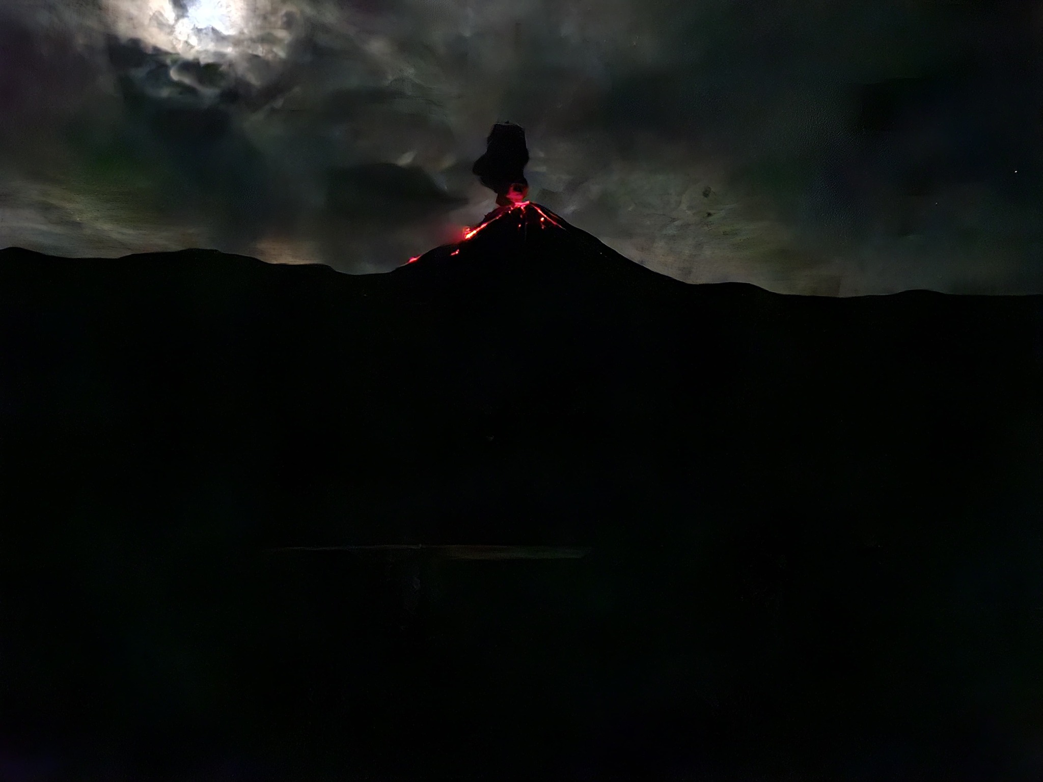
Ecuador , El Reventador :
DAILY STATUS REPORT OF REVENTADOR VOLCANO, Saturday, June 28, 2025.
Information Geophysical Institute – EPN.
Surface Activity Level: High, Surface Trend: No change
Internal Activity Level: Moderate, Internal Trend: No change
From June 27, 2025, 11:00 a.m. to June 28, 2025, 11:00 a.m.:
Seismicity:
Below is the count of seismic events recorded at the reference station.
Explosion (EXP) 95
Long Period (LP) 10
Emission Tremor (TREMI) 5
Harmonic Tremor (TRARM) 3
Rainfall/Lahars:
Precipitation was recorded in the area without generating mudflows or debris flows. **Heavy rainfall can remobilize accumulated material and generate debris-laden mudflows (lahars), which could cascade down the volcano’s flanks and drain into adjacent rivers.**
Emission/Ash Plume:
Yesterday afternoon and this morning, surveillance cameras and satellite images recorded several emissions of gas and ash, at heights ranging from 500 to 800 meters above the crater, in a west and southwest direction. Regarding this activity, the Washington VAAC issued four reports of ash plumes in a northwest and west direction, with heights of approximately 705 m.
Other Monitoring Parameters:
The VIIRS 750 and VIIRS 375 satellite systems recorded a weak thermal anomaly over the past 24 hours.
Observation:
During the night, the camera system observed the descent of incandescent material on the east-southeast and southeast flanks, up to 1,100 meters below the crater level. At the time of writing, the volcano was still completely cloudy.
Alert Level – SGR: Orange
Source : IGEPN
Photo : 07/2024 , volcanes ecuador/ FB.