June 22 , 2025.
Indonesia , Dukono :
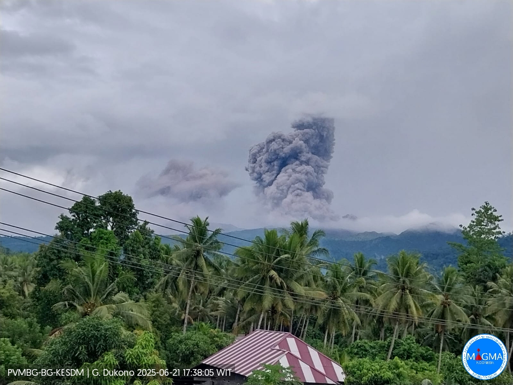
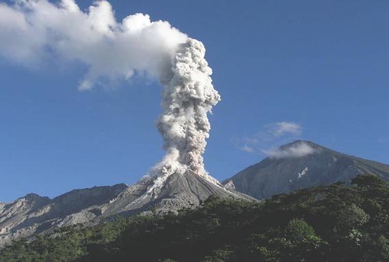
Mount Dukono erupted on Saturday, June 21, 2025, at 5:26 PM WIT. The observed ash column was ± 1,400 m above the summit (± 2,487 m above sea level). The ash column was white to gray, with a strong intensity, oriented toward the east. This eruption was recorded by seismograph with a maximum amplitude of 32 mm and a duration of 75.73 seconds.
VOLCANO OBSERVATORY NOTICE FOR AVIATION – VONA
Issued : June 21 , 20250619/0249Z
Volcano : Dukono (268010)
Current Aviation Colour Code : ORANGE
Previous Aviation Colour Code : orange
Source : Dukono Volcano Observatory
Notice Number : 2025DUK158
Volcano Location : N 01 deg 41 min 35 sec E 127 deg 53 min 38 sec
Area : North Maluku, Indonesia
Summit Elevation : 3478 FT (1087 M)
Volcanic Activity Summary :
Eruption with volcanic ash cloud at 17h26 (04h26 local).
Volcanic Cloud Height :
Best estimate of ash-cloud top is around 7958 FT (2487 M) above sea level or 4480 FT (1400 M) above summit. May be higher than what can be observed clearly. Source of height data: ground observer.
Other Volcanic Cloud Information :
Ash cloud moving to northwest. Volcanic ash is observed to be white. The intensity of volcanic ash is observed to be medium.
Remarks :
Eruption recorded on seismogram with maximum amplitude 32 mm and maximum duration 75,73 second. Tremor recorded on seismogram with maximum amplitude 3 mm.
Source et photo : Magma Indonésie
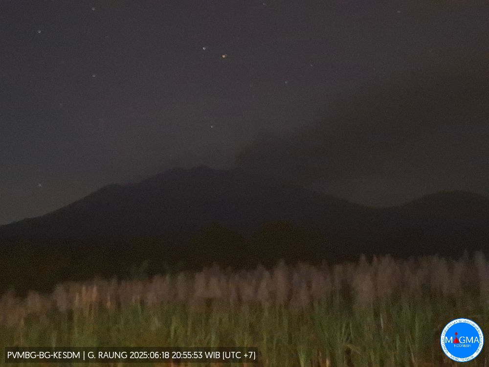
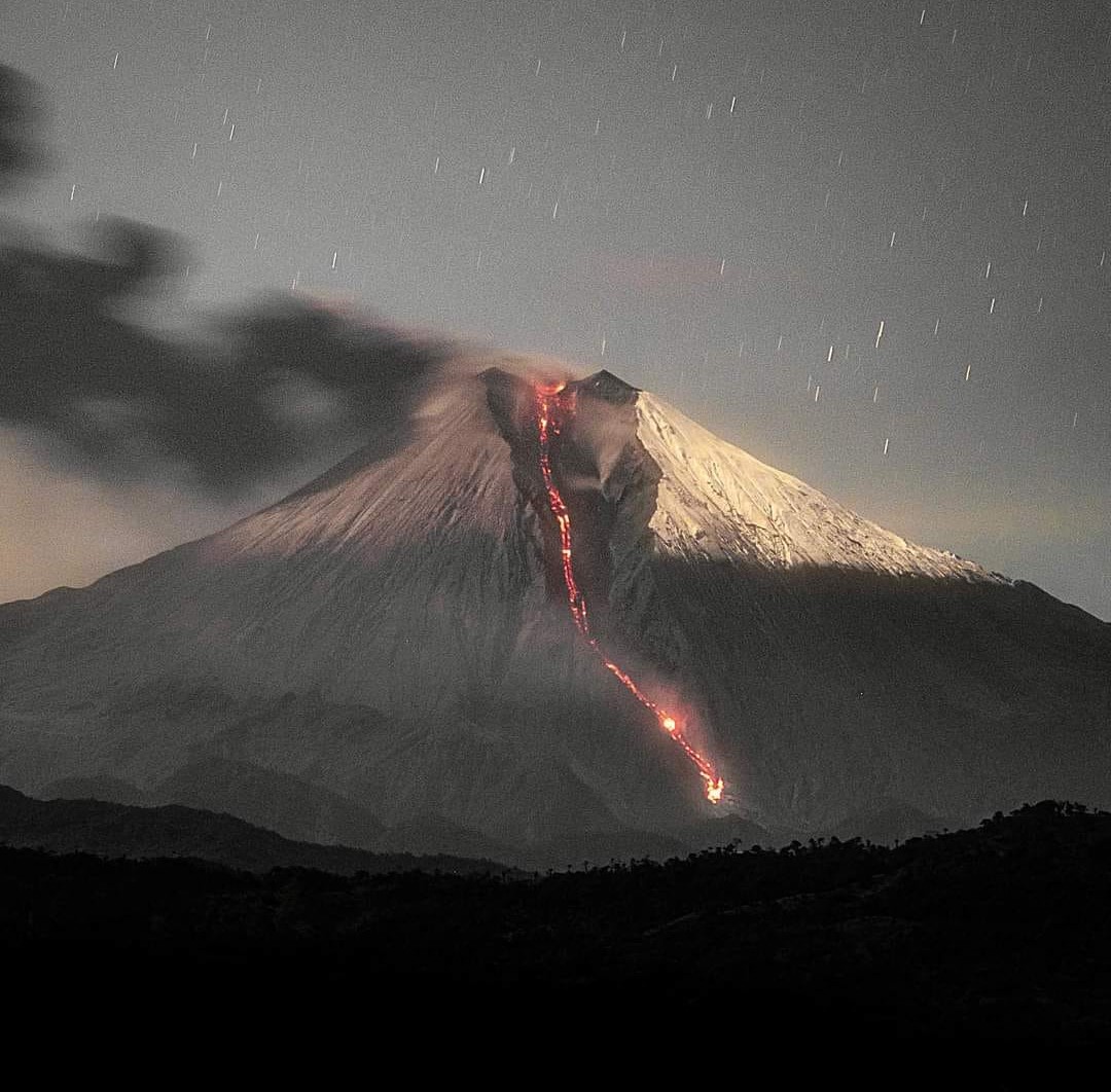
Indonesia , Raung :
RAUNG VOLCANO ACTIVITY, EAST JAVA, JUNE 20, 2025
Raung Volcano, one of the active volcanoes in East Java, has been on alert level II since December 19, 2023. Continuous eruptions have been occurring since June 5, 2025. On June 19, 2025, at 4:43 a.m. (Java Time), an eruption was observed, with the highest eruptive column during the continuous eruption period, approximately 2,000 m above the peak. On June 20, 2025, from 3:02 a.m. (Java Time) to 5:00 a.m. (Java Time), incandescence was observed toward the crater/peak, up to approximately 50 m from the summit. Thermal satellite imaging observations revealed a visible thermal anomaly at the base of Raung Crater on 18 June 2025. No thermal anomaly was detected on 20 June 2025. The intensity of the heat released is assumed to be still low, due to the emergence of high-temperature gases in the conduit system, opened by a series of eruptions since 5 June 2025.
Following the eruption on June 19, 2025, seismic activity at Mount Raung consisted of six eruption earthquakes, one distant tectonic earthquake, and a continuous tremor with amplitudes ranging from 0.5 to 6 mm, with a dominant value of 1 mm. Seismic energy observations showed fluctuations, and a decreasing trend was observed on June 20, 2025, likely due to the release of significant fluids during the eruption on June 19, 2025.
The series of eruptions at Mount Raung, from June 5 to 20, 2025, produced a dominant mass of ash-sized material, mainly distributed around the crater, and therefore did not change the hazard level. The activity level is still considered relevant, at Level II (WASPADA), with a recommendation not to undertake activities within a 3 km radius of the crater/summit.
Regarding the volcanic activity of Mount Raung, the public should comply with the recommendations issued by the Geological Agency through the Center for Volcanology and Geological Disaster Mitigation, and not be misled by false and irresponsible reports regarding the activity of Mount Raung. They should also follow the instructions of the authorized agency, namely the Geological Agency, which will continue to coordinate with the BNPB, the BMKG, ministries/institutions, regional governments, and other relevant agencies.
Source et photo : PVMBG
Colombia , Nevado del Ruiz :
Manizales, June 17, 2025, 6:50 p.m.
Regarding the monitoring of the activity of the Nevado del Ruiz volcano, the Colombian Geological Survey (SGC), an entity attached to the Ministry of Mines and Energy, reports that:
From June 10 to 16, 2025, the volcano continued to exhibit unstable behavior. Compared to the previous week, the main variations in the monitored parameters were:
– Seismic signals related to fluid dynamics in the volcanic conduits recorded an increase in the number of events and a decrease in the seismic energy released. These seismic signals were mostly low-energy, with occasional moderate levels. Thanks to the cameras (conventional or thermographic) used to monitor the volcano, it was possible to confirm some pulsatile ash emissions associated with these signals. However, confirmation of this phenomenon, as well as apparent temperature variations of the ejected materials, has been limited due to atmospheric conditions of high cloud cover in the area.

Seismic activity associated with rock fracturing processes within the volcanic edifice decreased, both in terms of the number of recorded events and the seismic energy released.
The seismic events were located in the Arenas crater and, scattered across the volcano’s various flanks, with a greater proportion on the eastern and northeastern flanks.
The distance of the earthquakes from the crater varied between 1 and 10 km, with depths ranging from less than 1 km to 7 km measured from the volcano’s summit. The magnitudes of the earthquakes were less than 1.
Emissions of water vapor and gases, mainly sulfur dioxide (SO2), into the atmosphere from the Arenas crater were variable and decreased compared to the previous week. This was partly due to unfavorable atmospheric conditions (wind direction and speed) at the monitoring stations. Ongoing satellite monitoring, in addition to the assessment of this parameter, continues to reveal SO2 emissions. – The vertical height of the gas, ash, and water vapor column remained below 800 m measured above the volcano’s summit, although this estimate was affected by the atmospheric conditions (thick cloud cover) that persisted in the region throughout the week. The column’s dispersion direction showed a predominant trend toward the northwest and northeast flanks of the volcano.
– When monitoring thermal anomalies at the floor of Arenas Crater using satellite monitoring platforms, detection was limited by the region’s heavy cloud cover; however, some reports of low energy levels were obtained.
Source et photo : SGC
Ecuador , Sangay :
SANGAY VOLCANO DAILY STATUS REPORT, Saturday, June 21, 2025.
Information Geophysical Institute – EPN.
Surface Activity Level: High, Surface Trend: No Change
Internal Activity Level: Moderate, Internal Trend: No Change
Seismicity: From June 20, 2025, 11:00 a.m. to June 21, 2025, 11:00 a.m.:
Seismicity:
Below is the count of seismic events recorded at the reference station.
Explosion (EXP): 115
Rainfall/Lahars:
Since yesterday afternoon, no rain has been recorded in the volcano area. **Heavy rains could remobilize accumulated material, generating mud and debris flows that would cascade down the volcano’s flanks and drain into adjacent rivers**.
Emission/Ash Column:
Last night, the GOES-19 satellite observed an emission of gas and ash at an altitude between 800 meters above the crater, in a southwesterly direction. In addition, the Washington VAAC issued three reports of surface activity at altitudes of approximately 600 and 1,800 meters, in a west and west-southwest direction.
Other monitoring parameters:
The FIRMS satellite system recorded five thermal anomalies, the MIROVA-MODIS satellite system one thermal anomaly, and the MIROVA-VIIRS satellite system four thermal anomalies over the past 24 hours.
Observation:
From yesterday afternoon until the closing of this report, the volcano remained completely or partly cloudy.
Alert level: Yellow
Source : IGEPN
Photo : Eqphos_fotografía
Guatemala , Santiaguito :
Weather: Clear sky.
Wind: West.
Precipitation: 50.5 mm.
Activity:
The Santa María-Santiaguito Volcanic Complex Observatory reports volcanic activity on the Caliente Dome, consisting of weak explosions occurring at a rate of 2 to 4 per hour, which are lifting columns of gas and ash up to 800 meters above the Caliente Dome, moving east and southeast. A weak, almost constant outgassing is also observed from the northern and northeastern edges of the dome, lifting columns of water vapor and other magmatic gases up to 300 meters above the dome.
In the early morning, incandescent lava was observed on the dome and on the promontory above the lava flow on the western flank, as well as the detachment of incandescent lava blocks towards the western and southern flanks. Minor ashfall could be recorded in areas located to the south and southeast of the domes, from Viejo Palmar to Santa María de Jesús and El Palmar Nuevo. Activity remains high, which leaves the possibility of large pyroclastic flows towards the southwest, south and southeast.
Source : Insivumeh .
Photo : La Hora .