June 15 , 2025.
Indonesia , Raung :
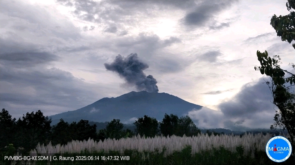
Mount Raung erupted on Saturday, June 14, 2025, at 4:43 PM WIB. The observed ash column was ± 1,500 m above the summit (± 4,832 m above sea level). The ash column was gray to black, with moderate to thick intensity, oriented toward the southwest and west. At the time of this report, the eruption was still ongoing.
VOLCANO OBSERVATORY NOTICE FOR AVIATION – VONA
Issued : June 14 , 2025
Volcano : Raung (263340)
Current Aviation Colour Code : ORANGE
Previous Aviation Colour Code : orange
Source : Raung Volcano Observatory
Notice Number : 2025RAU021
Volcano Location : S 08 deg 07 min 30 sec E 114 deg 02 min 31 sec
Area : East java, Indonesia
Summit Elevation : 10662 FT (3332 M)
Volcanic Activity Summary :
Eruption with volcanic ash cloud at 09h43 UTC (16h43 local).
Volcanic Cloud Height :
Best estimate of ash-cloud top is around 14502 FT (4532 M) above sea level or 3840 FT (1200 M) above summit. May be higher than what can be observed clearly. Source of height data: ground observer.
Other Volcanic Cloud Information :
Ash cloud moving to west. Volcanic ash is observed to be gray. The intensity of volcanic ash is observed from medium to thick.
Remarks :
Tremor recorded on seismogram with maximum amplitude 4 mm. Seismic activity is characterized by continuous tremor .
Source et photo : Magma Indonésie.
Costa Rica , Poas :
Latitude: 10.20°N;
Longitude: 84.23°W;
Altitude: 2,687 m
Current Activity Level: Caution
Following the eruption on May 19, no further explosive events have been recorded. However, weak ash emissions were observed last week, particularly on June 10.
This week, the amplitude of the continuous seismic tremor increased slightly and gradually, but remains low compared to previous months. The acoustic tremor remained almost constant, with little variation. In particular, a low-frequency acoustic tremor was observed accompanying the ash emission on June 10.
Previously, between June 8 and 9, two short seismic tremors with a weak acoustic component were recorded. The weak ash emissions observed this week did not exhibit a seismic signal. The number of long-period events decreased this week. Occasional volcano-tectonic earthquakes were recorded, both distal and proximal. Geodetic monitoring has detected vertical uplift and extension of the crater crust since December 2024, with amplitude varying from week to week. Overall, ground uplift north of the crater reached 3 to 4 cm, comparable to that observed during the 2017 eruption. However, in recent weeks, uplift and extension of the crater have ceased, and a subsidence process is currently observed. Degassing has decreased over the past month.
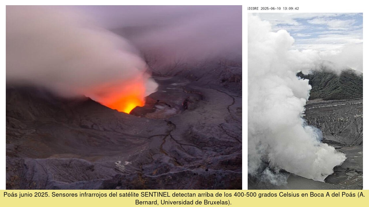
The last week of SO2 flux measurements by DOAS stations indicates an average flux of 150 ± 220 tons per day, compared to weekly averages reaching up to 500 tons per day in April. Peak SO2 fluxes still reach nearly 2,000 tons per day, indicating that degassing remains significant. The mass of SO2 measured in the atmosphere using the TROPOMI sensor on the Sentinel-5P satellite remained above 300 tons, with a peak exceeding 1,000 tons on June 12. Gas composition measurements are consistent with a decrease in magmatic input in recent weeks. The MultiGAS station near Boca A measured an average SO2/CO2 ratio of 1.5 ± 0.5, compared to values of 3 to 4 in May. The H2S/SO2 ratio has been very low (< 0.1) in recent weeks. The gases are interpreted to be coming from a surface magmatic source, but the magmatic input is decreasing. The lake level in Boca C continues to rise. Mouth A remains dry with incandescent light throughout the night.
Source : Ovsicori.
Photo : Ovsicori , B Bernard.
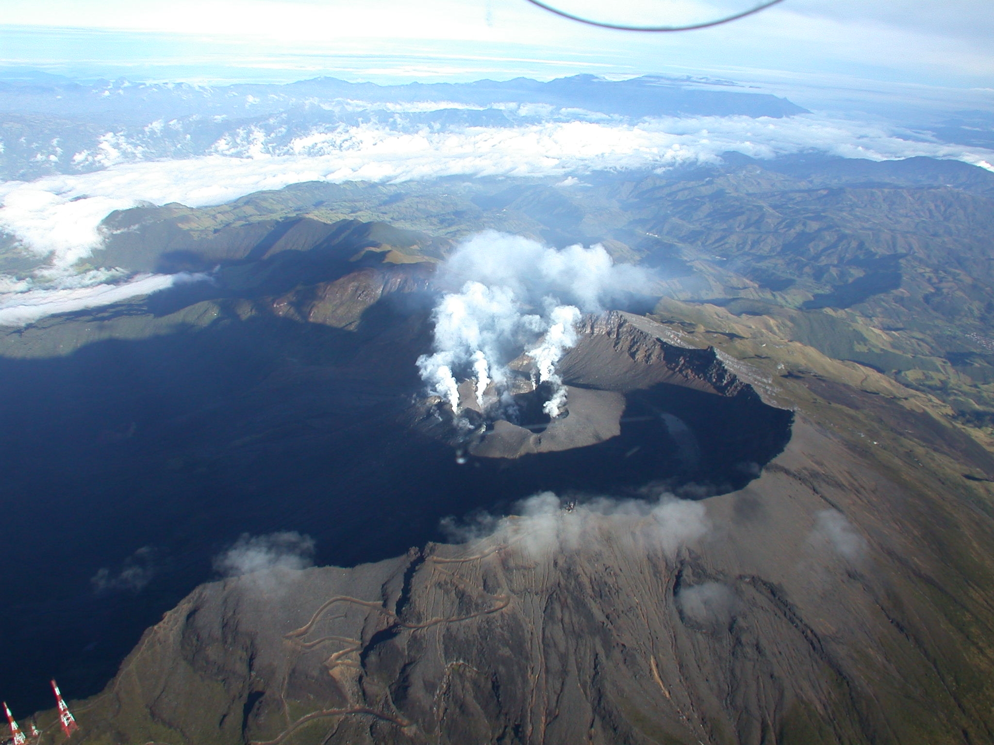
Colombia , Galeras :
San Juan de Pasto, June 10, 2025, 5:30 a.m.
Following monitoring of the activity of the Galeras Volcano, the Colombian Geological Survey (SGC), an entity affiliated with the Ministry of Mines and Energy, reports that:
During the week of June 3 to 9, 2025, the main variations in the monitored parameters compared to the previous week were:
● A decrease in the occurrence and released seismic energy was recorded.
● The seismicity of rock fractures within the volcanic edifice continues to dominate volcanic activity processes.
● Regarding fracture earthquakes, on June 5 at 3:49 a.m., an earthquake was recorded 14.8 km northeast of the crater of the Galeras volcano and at a depth of 7.9 km from its summit (4,200 m above sea level). This event, with a magnitude of 2.1, was felt in the municipality of Chachagüí. In this direction, other earthquakes occurred at distances between 2.6 and 12.6 km from the volcano, at depths between 5.7 and 12 km from its summit, and reached a maximum magnitude of 1.1. Most of the earthquakes were located near the crater of the volcano, concentrated less than 1 km east of the crater, less than 2.5 km deep from the summit, and reached a maximum magnitude of 0.3. Other earthquakes were scattered throughout the volcanic area, at distances of less than 13 km and up to 12 km deep, and reached a maximum magnitude of 1.2.
● Columns of white gas emissions were observed, with variable dispersion depending on wind action. These columns originated from the fumarole fields of El Paisita, to the north, and Las Chavas, to the west of the crater, within the active cone.
In view of the above, the SGC recommends closely monitoring the situation through weekly bulletins and other information published through our official channels, as well as instructions from local and departmental authorities and the National Disaster Risk Management Unit (UNGRD).
Volcanic activity remains on yellow alert: active volcano with changes in the baseline behavior of monitored parameters and other manifestations.
Source et photo : SGC.
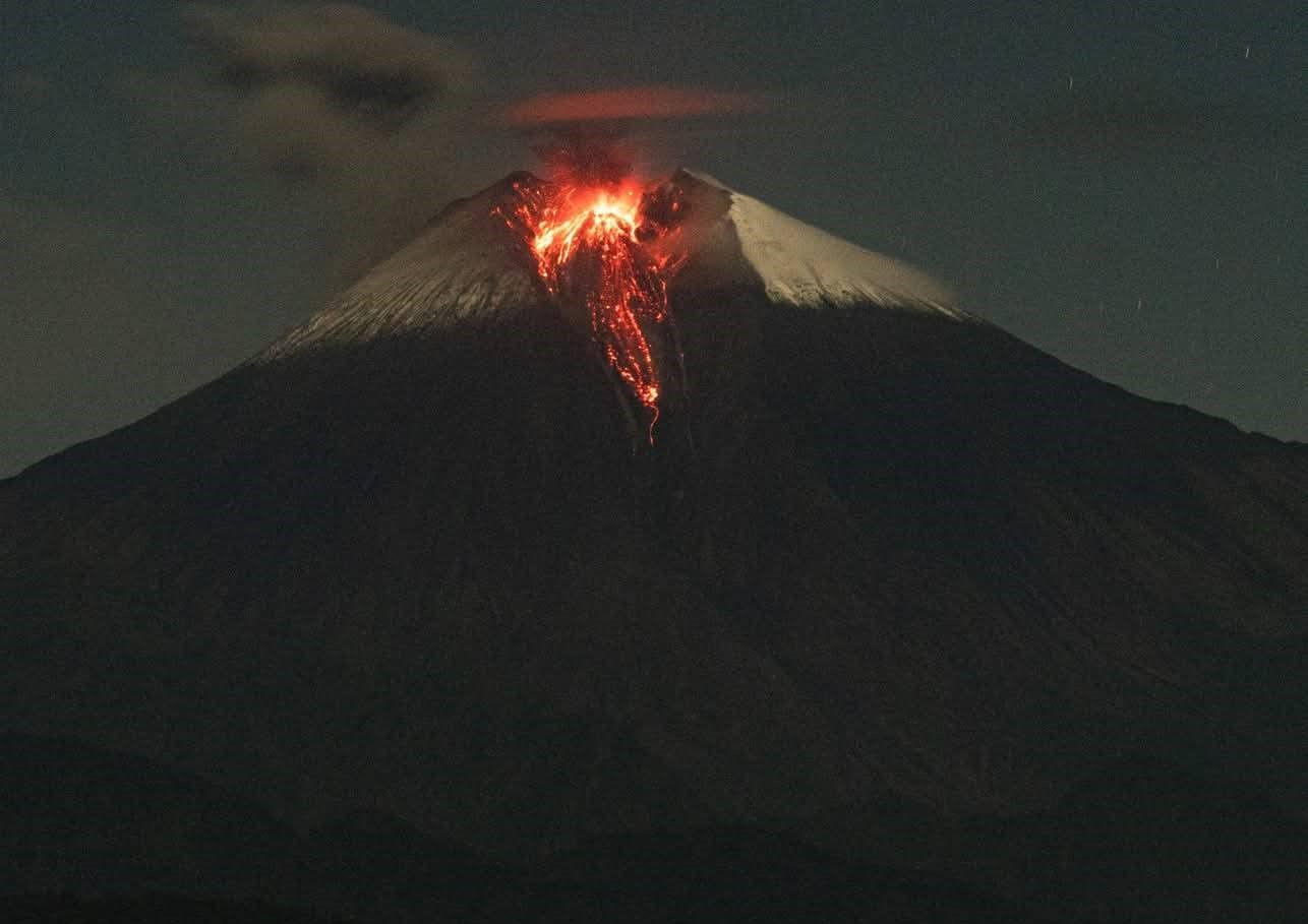
Ecuador , Sangay :
DAILY STATUS REPORT OF SANGAY VOLCANO, Saturday, June 14, 2025.
Information Geophysical Institute – EPN.
Surface Activity Level: High, Surface Trend: No change
Internal Activity Level: Moderate, Internal Trend: No change
Seismicity: From June 13, 2025, 11:00 a.m. to June 14, 2025, 11:00 a.m.:
Seismicity:
Below is the count of seismic events recorded at the reference station.
Explosion (EXP): 217
Precipitation/Lahars:
Since yesterday afternoon, no rain has been recorded in the volcano area. **Heavy rains could remobilize the accumulated material, generating mud and debris flows that would cascade down the sides of the volcano and drain into adjacent rivers**.
Emissions / Ash Column:
Since yesterday afternoon, several columns of gas and ash have been recorded by the surveillance camera network at heights ranging from 500 to 2,000 meters above the crater level, in a west and northwest direction. These emissions were also detected by the GOES-19 satellite system in a northwest direction. Regarding this activity, the Washington VAAC has issued four reports of ash clouds in a west and northwest direction, at heights of 1,200 and 1,500 meters above the crater level.
Gas:
The MOUNTS satellite system recorded 88.9 tons of sulfur dioxide (SO2), measured yesterday at 1:31 PM.
Other monitoring parameters:
The MIROVA-MODIS satellite system detected one thermal anomaly, the MIROVA-VIIRS system four thermal anomalies, and the FIRMS satellite system 21 thermal anomalies over the past 24 hours.
Observation:
During the night and early morning, several episodes of incandescent material emissions were recorded, descending down the volcano’s flanks up to 1,000 meters below the crater level. At the time of writing, the volcano remains completely cloudy.
Alert level: Yellow
Source : IGEPN
Photo : Cristopher Cárdenas ,12/06/2025.
Guatemala , Santiaguito :
Weather: Cloudy.
Wind: Northeast.
Precipitation: 26.0 mm.
Activity:
Activity is reported at the Caliente dome of the Santa María-Santiaguito volcanic complex, characterized by white degassing at an altitude of 500 meters above the crater. Weak to moderate explosions are generated, raising columns of gas and ash to heights of 800 to 900 meters above the dome, carried by the wind toward the west and southwest.
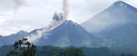
During the night, incandescence was observed in the crater. The Santiaguito Volcano Observatory (OVSAN) reports the collapse and descent of volcanic material towards the south and southwest flanks of the dome. Activity remains high; it is therefore possible that due to explosions or the effect of gravity, some of the accumulated material could collapse and generate pyroclastic flows over long distances towards the southwest, south and southeast. It is therefore advisable to follow the recommendations of special bulletin BESAN-002-2025. Likewise, rains could cause the descent of lahars into different ravines of the volcano.
Source : Insivumeh .
Photo : Conred (11/06/2025)