June 10 , 2025.
Kamchatka , Sheveluch :
VOLCANO OBSERVATORY NOTICE FOR AVIATION (VONA)
Issued: June 09 , 2025
Volcano: Sheveluch (CAVW #300270)
Current aviation colour code: ORANGE
Previous aviation colour code: orange
Source: KVERT
Notice Number: 2025-32
Volcano Location: N 56 deg 38 min E 161 deg 18 min
Area: Kamchatka, Russia
Summit Elevation: 3283 m (10768.24 ft), the dome elevation ~2500 m (8200 ft)
Volcanic Activity Summary:
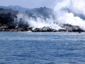
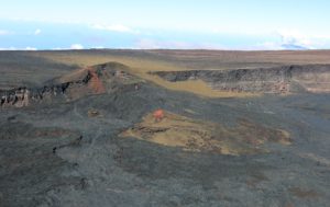
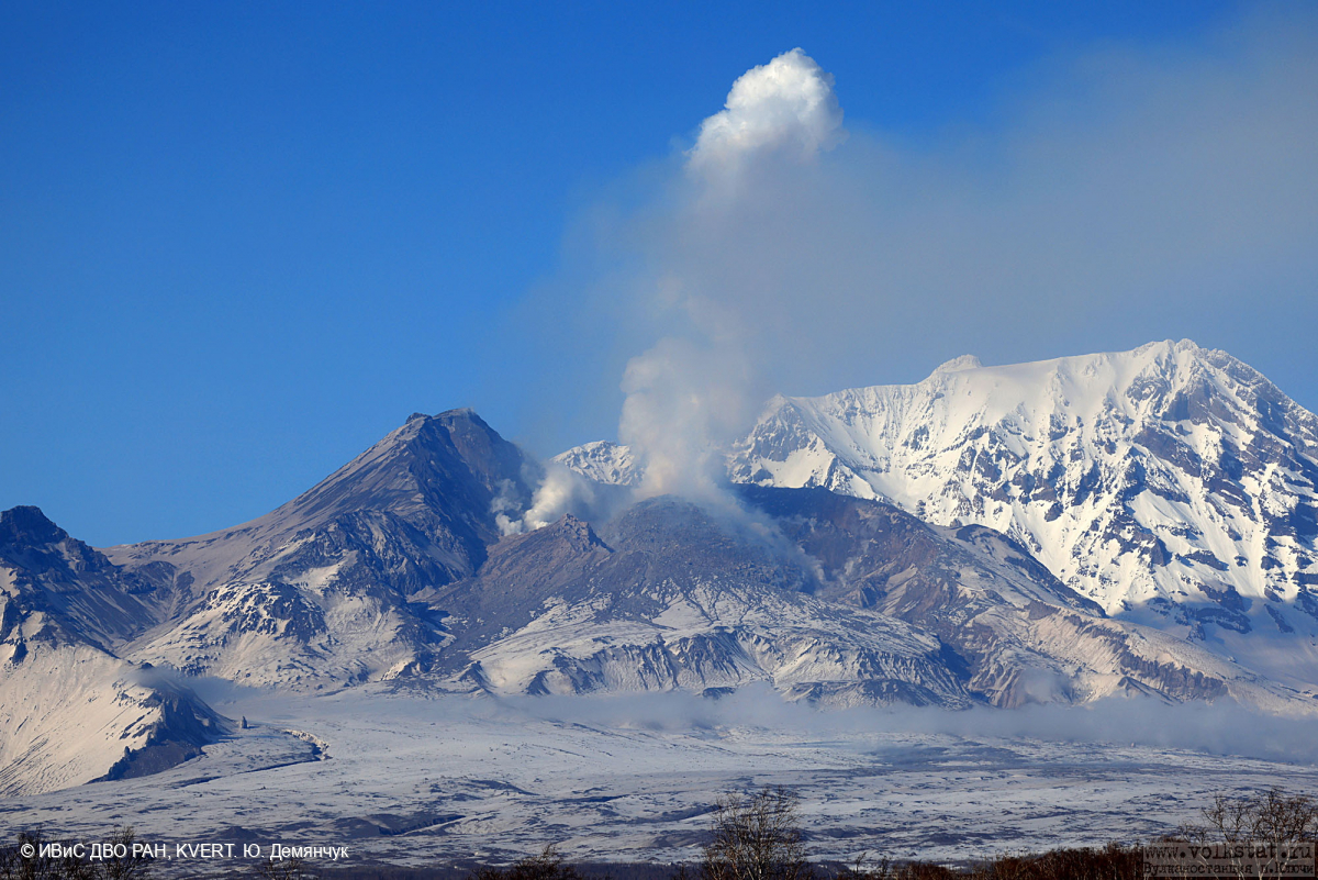
An extrusive-effusive eruption of the volcano continues. According to video data by KVERT, explosions sent ash up to 6 km a.s.l., and an ash cloud to move about 5 km to the west of the volcano.
An extrusive-effusive eruption of the volcano continues. A danger of ash explosions up to 10 km (32,800 ft) a.s.l. remains. Ongoing activity could affect international and low-flying aircraft.
Volcanic cloud height:
6000 m (19680 ft) AMSL Time and method of ash plume/cloud height determination: 20250609/2110Z – Video data
Other volcanic cloud information:
Distance of ash plume/cloud of the volcano: 5 km (3 mi)
Direction of drift of ash plume/cloud of the volcano: W / azimuth 265 deg
Time and method of ash plume/cloud determination: 20250609/2120Z – Video data
Source : Kvert
Photo : Yu. Demyanchuk, IVS FEB RAS, KVERT.
Indonesia , Dukono :
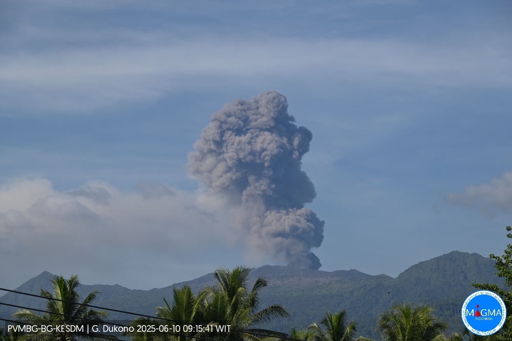
Mount Dukono erupted on Tuesday, June 10, 2025, at 9:06 a.m. local time. The observed ash column reached ± 1,200 m above the summit (± 2,287 m above sea level). The ash column was white to gray, with significant intensity, oriented toward the east. At the time of this report, the eruption was still ongoing.
VOLCANO OBSERVATORY NOTICE FOR AVIATION – VONA
Issued : June 10 , 2025
Volcano : Dukono (268010)
Current Aviation Colour Code : ORANGE
Previous Aviation Colour Code : orange
Source : Dukono Volcano Observatory
Notice Number : 2025DUK137
Volcano Location : N 01 deg 41 min 35 sec E 127 deg 53 min 38 sec
Area : North Maluku, Indonesia
Summit Elevation : 3478 FT (1087 M)
Volcanic Activity Summary :
Eruption with volcanic ash cloud at 00h06 UTC (09h06 local).
Volcanic Cloud Height :
Best estimate of ash-cloud top is around 7318 FT (2287 M) above sea level or 3840 FT (1200 M) above summit. May be higher than what can be observed clearly. Source of height data: ground observer.
Other Volcanic Cloud Information :
Ash cloud moving to east. Volcanic ash is observed to be white to gray. The intensity of volcanic ash is observed from medium to thick.
Remarks :
Eruption and ash emission is continuing. Eruption recorded on seismogram with maximum amplitude 24 mm. Tremor recorded on seismogram with maximum amplitude 3 mm.
Source et photo : Magma Indonésie .
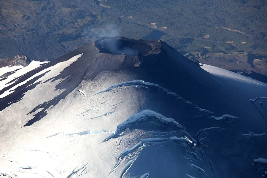
Chile , Villarica :
Seismology
Seismological activity during this period was characterized by:
3 VT-type seismic events, associated with rock fracturing (volcano-tectonics).
2,635 LP-type seismic events, associated with fluid dynamics within the volcanic system (long period). The magnitude of the strongest earthquake, evaluated using the reduced displacement (RD) parameter, was 14.6 cm².
13 TR-type seismic events, associated with sustained fluid dynamics within the volcanic system (TRemor). The magnitude of the strongest earthquake, evaluated using the reduced displacement (RD) parameter, was 4.2 cm².
Fluid Geochemistry
Sulfur dioxide (SO2) emission data obtained by Differential Optical Absorption Spectroscopy (DOAS) at the Los Nevados and Tralco stations, located 10 km east-northeast and 6 km east-southeast of the active crater, respectively, showed an average value of 812 ± 123 t/d for the month of May. These values are considered normal for this volcanic system. The maximum daily average was 1,980 t/d on May 7.
No anomalies in sulfur dioxide (SO2) emissions into the atmosphere have been reported in the area near the volcano, according to data published by the Tropospheric Monitoring Instrument (TROPOMI) and the Sulfur Dioxide Monitoring Group of the Ozone Monitoring Instrument (OMI).
Geodesy
According to data from the GNSS network, which measures the volcano’s surface deformation, a period of stability is observed in the system. This is reflected in the low horizontal and vertical displacement rates, which have not exceeded 0.5 cm per month, values consistent with the annual cycle recorded since the stations were installed. Similarly, variations in distance between GNSS stations show shortening or lengthening rates of less than 0.4 cm per month. Radar interferometry (InSAR) data processed by the Mounts and COMET platforms over a 12-day time period, from April 28 to May 9 and from May 9 to 21, show no significant deformation of the volcano.
Surveillance Cameras
Images provided by fixed cameras installed near the volcano recorded intermittent, diffuse, and low-energy degassing plumes emanating from the crater. The highest degassing plume was recorded on May 29, reaching 200 m above the crater level. No ash emissions or incandescence were recorded during the assessed period.
Satellite Geomorphological Analysis
No morphological changes were identified in this volcanic system based on combined true-color band images from Planet Scope or Sentinel 2-L2A during the month of May.
Activity remained at levels considered low, suggesting the volcano’s stability.
The technical volcanic alert remains in effect:
GREEN TECHNICAL ALERT: Active volcano with stable behavior – No immediate risk.
Observation:
Monitoring of the volcano’s surface and instrumental activity indicate a decrease in the frequency of explosions emitting high-temperature volcanic material outside the crater. Given that this is an open-conduit volcanic system, sudden explosions without precursors cannot be ruled out. Consistent with observations from previous periods, the impact of these explosions is mainly concentrated at distances less than 500 m, measured from the crater center. However, in the current scenario, the low surface activity, combined with the decrease in monitoring parameters, suggests a low probability of this type of activity occurring. Associated risks include the ejection of ballistic pyroclasts and the emission of ash and volcanic gases.
Source : Sernageomin .
Photo : Aton
Costa Rica , Rincon de la Vieja :
Latitude: 10.83
Longitude: -85.324
Altitude: 1,916 m
Observed Activity:
Slight tremors have been detected, but no significant eruption has been recorded in the past 24 hours. Geodetic stations show contraction at the base of the volcano.
Environmental Conditions:
Winds are mainly from the west and north.
Activity Level: Warning (2)

Three eruptions and three exhalations were recorded this week. The most energetic eruption occurred on Saturday, May 31, at 3:47 p.m.; however, it did not generate lahars or ash emissions. This event corresponds to the most energetic event (acoustic instruments) of 2025. Subsequent eruptive events gradually decreased in energy throughout the week. The frequency of seismic « Tornillos » events and long-period (LP) events continues. The number of LP events returned to the baseline level after the May 31 eruption. The dominant frequency of tornillos in 2025 remains generally stable, with a slight downward trend. The background volcanic tremor remains stable with a slight increase in frequency amplitude, between 2 and 6 Hz. A short tremor episode was recorded on June 4 for one hour. Geodetic observations show a slight base contraction. This week’s eruptions increased the average SO2 flux (231 ± 352 t/d) compared to the previous week (83 ± 46 t/d). The TROPOMI sensor on the Sentinel-5P satellite detected a small amount of atmospheric SO2 emitted from Rincón de la Vieja on June 2 (~71 t/d).
Source : Ovsicori.
Photo : Federico Chavarría-Kopper – Ovsicori
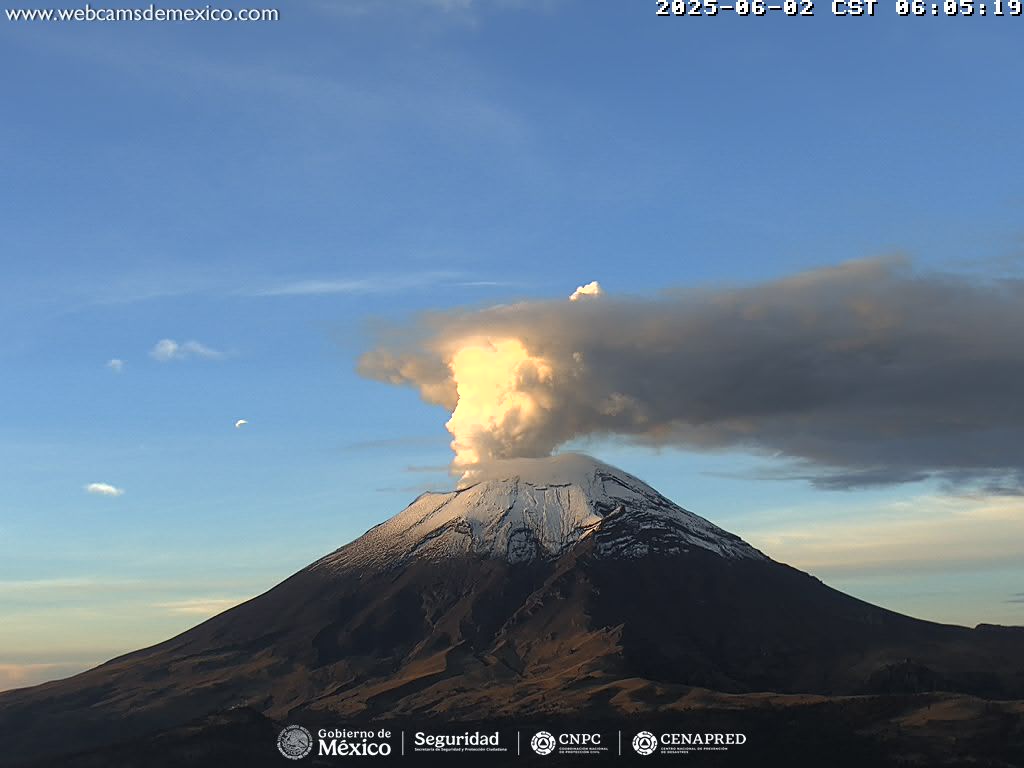
Mexico , Popocatepetl :
June 9, 11:00 a.m. (June 9, 5:00 p.m. GMT)
Activity in the past 24 hours
33 low-intensity exhalations were detected, accompanied by water vapor, other volcanic gases, and occasionally small amounts of ash. 427 minutes of low-amplitude tremor were also recorded: 121 minutes of high-frequency tremor and 306 minutes of harmonic tremor.
In addition, today at 1:12 a.m., a volcano-tectonic earthquake with an estimated magnitude of 2.2 was detected.
During the morning and at the time of writing, slight and constant emissions of water vapor and other volcanic gases were observed in a westerly direction.
The Popocatépetl volcano fire alert is at yellow phase 2.
The expected scenarios for this phase are as follows:
A few minor to moderate explosions
Occurrence of tremors of varying amplitude
Light to moderate ashfall in surrounding towns and some more distant towns
Expulsion of incandescent fragments within a 12-kilometer exclusion radius
Lahars descending into ravines are expected due to ash accumulation on the slopes and their interaction with the precipitation expected in the coming weeks
Possibility of pyroclastic flows not reaching towns
Source : Cenapred .