June 04 , 2025.
Hawaii , Kilauea :
HVO/USGS Volcanic Activity Notice
Current Volcano Alert Level: WATCH
Current Aviation Color Code: ORANGE
Issued: Tuesday, June 3, 2025, 12:36 PM HST
Source: Hawaiian Volcano Observatory
Notice Number: 2025/H256
Location: N 19 deg 25 min W 155 deg 17 min
Elevation: 4091 ft (1247 m)
Area: Hawaii
Volcanic Activity Summary:
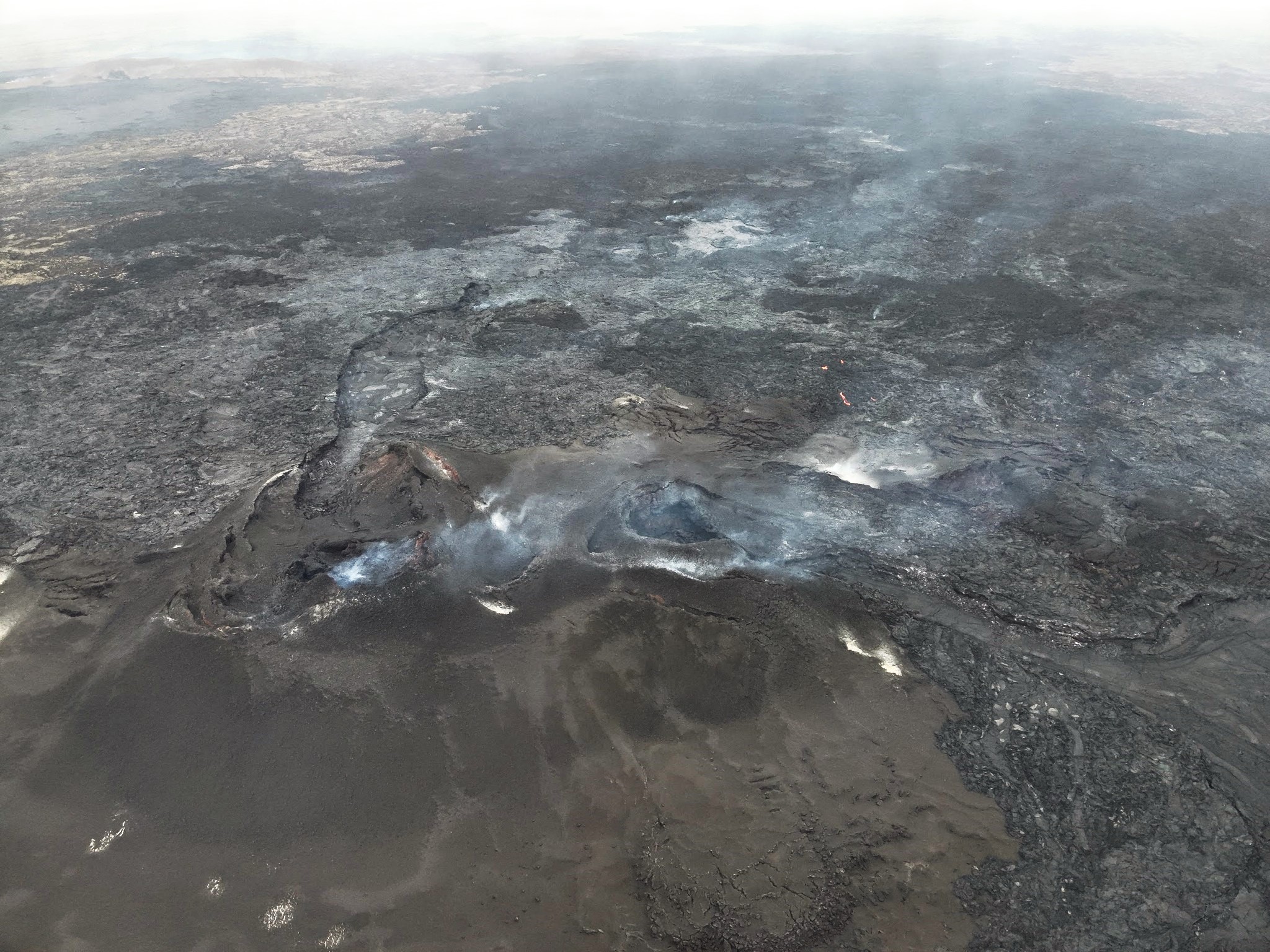
Episode 24 precursory activity started within Halemaʻumaʻu during the morning of June 3. Vigorous degassing of sulfur dioxide (SO2), nighttime glow, and intermittent lava spattering in the north vent indicate that magma is close to the surface. Episode 24 is likely to begin today or tomorrow.
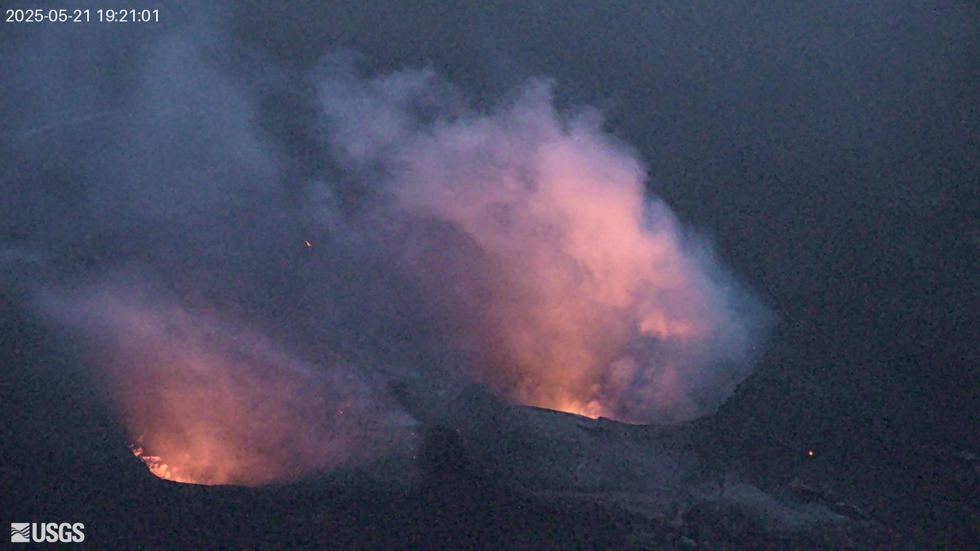
In recent episodes of the ongoing eruption within Halemaʻumaʻu, low-level precursory activity has lasted from a few hours to a few days. This activity can include spatter from north and/or south vents, small dome fountains, and lava overflowing from one or both vents. At the start of previous episodes, precursory activity has rapidly escalated into sustained high fountaining over minutes to tens of minutes.
The tiltmeter at Uēkahuna (UWD) has recorded just over 12 microradians of inflationary tilt since the end of the last episode. Low level seismic tremor continues beneath Halemaʻumaʻu crater.
Most episodes of Halemaʻumaʻu lava fountaining since December 23, 2024, have continued for around a day or less and have been separated by pauses in eruptive activity lasting generally at least several days.
No changes have been detected in the East Rift Zone or Southwest Rift Zone. A VAN/VONA will be issued when sustained lava fountaining begins, marking the start of episode 24, or earlier if the situation warrants a further update.
Recent Observations:
Sulfur dioxide emission rates are typically 1,200-1,500 tonnes/day between eruptive episodes and 50,000 tonnes/day during an eruptive episode
Source et photo : HVO
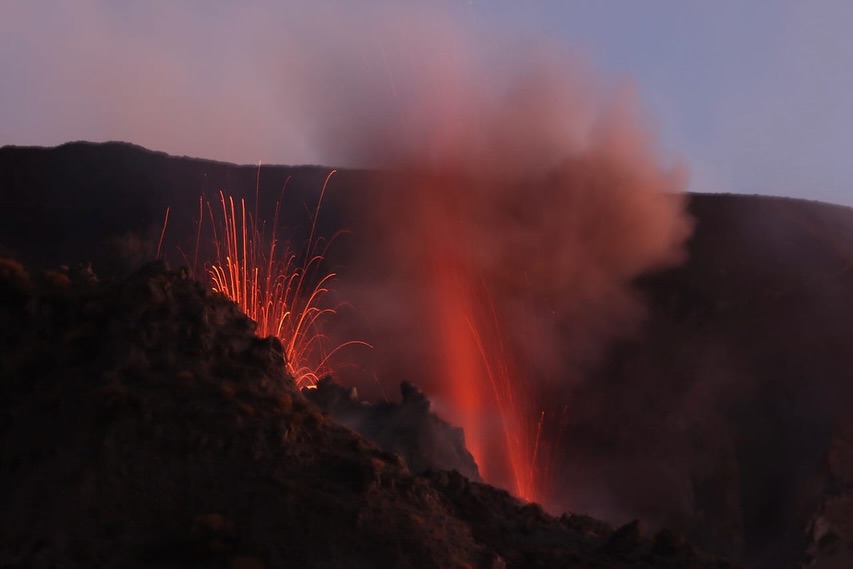
Italy , Stromboli :
WEEKLY BULLETIN, from May 26, 2025 to June 1, 2025 (publication date: June 3, 2025)
ACTIVITY STATUS SUMMARY
Based on monitoring data, the following points are highlighted:
1) VOLCANOLOGICAL OBSERVATIONS: Ordinary Strombolian eruptive activity. The total hourly frequency ranged between average values (8 to 13 events/h). The intensity of the explosions was low and medium in the North and South-Central crater areas.
2) SEISMOLOGY: The monitored seismological parameters show no significant variations.
3) GROUND DEFORMATION: Ground deformation monitoring networks showed no significant variations.
4) GEOCHEMISTRY: SO2 flux: average level. Soil CO2 flux in the Pizzo area (STR02): No update.
C/S ratio in the plume: High to very high values.
Dissolved helium isotope ratio (R/Ra) in the thermal aquifer: No update.
Soil CO2 flux in the San Bartolo area: Average values.
Soil CO2 flux in the Scari area: Average to low values.
5) SATELLITE OBSERVATIONS: Thermal activity observed by satellite in the summit area was generally low in intensity, with some moderate thermal anomalies.
VOLCANOLOGICAL OBSERVATIONS
During the observation period, Stromboli’s eruptive activity was characterized by analyzing images recorded by INGV-OE surveillance cameras located at an altitude of 190 m (SCT-SCV) and at Punta dei Corvi (SPCT). Explosive activity was mainly produced by four eruptive vents located in the northern area of the crater and by at least two vents located in the central-southern area.
Due to adverse weather conditions, visibility of the crater terrace on May 28 was insufficient for an accurate description of the eruptive activity.
Observations of Explosive Activity Recorded by Surveillance Cameras
In the northern (N) crater area, four active vents were observed, producing explosive activity of low intensity (less than 80 m in height) and sometimes medium intensity (less than 150 m in height). The eruptive products were mainly composed of coarse materials (bombs and lapilli). The average explosion frequency ranged from 4 to 8 events/h.
In the South-Central (SC) zone, explosive activity was produced by at least two vents. The explosions were mainly of low and medium intensity and produced fine materials (ash) sometimes mixed with coarse materials (lapilli and bombs). The average explosion frequency ranged from 3 to 5 events/h.
Source : INGV
Photo : Stromboli stati d’animo / Sebastiano Cannavo.
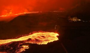
Iceland , Reykjanes Peninsula :
Continued Uplift in Svartsengi , Update 3. June
Based on the rate of magma accumulation in recent weeks, the likelihood of a new eruption is expected to increase as autumn approachesSeismic activity near the dike continues to decrease
Seismic activity near the dike continues to decrease
The hazard assessment remains unchanged and is valid until June 18, provided no changes occur
Uplift and magma accumulation continue beneath Svartsengi. However, the rate of magma accumulation continues to gradually decrease compared to the rates observed in April and the first half of May. If magma accumulation continues at a similar pace as in recent weeks, the likelihood of a magma intrusion or eruption is expected to increase as autumn approaches. Changes in the rate of uplift—and therefore magma accumulation—beneath Svartsengi could, however, influence this assessment.
In recent days, between 10 and 20 small earthquakes have been recorded each day in the area around the dike that formed on April 1, 2025. Seismic activity has steadily decreased in recent weeks. Most of the earthquakes are concentrated in two clusters: one in the southern part of the dike near Grindavík and the other in the area between Sundhnúkur and Stóra Skógfell. Occasional earthquakes are also detected near the northern end of the dike, north of Keilir.
The hazard assessment has been updated and remains unchanged. It is valid until June 18, provided no changes occur. The next update will also be issued on June 18.
Source : IMO
Photo : Ljósmynd: Almannavarnir/Björn Oddsson .
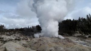
Indonesia , Dukono :
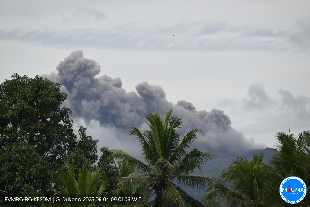
Mount Dukono erupted on Wednesday, June 4, 2025, at 10:01 a.m. local time. The observed ash column was ± 500 m above the summit (± 1,587 m above sea level). The ash column was white to gray, with significant intensity, oriented toward the east. At the time of this report, the eruption was still ongoing.
Seismicity Observation
78 eruption earthquakes with an amplitude of 6 to 34 mm and a duration of 32.83 to 144.36 seconds.
6 distant tectonic earthquakes with an amplitude of 14 to 34 mm and a duration of 73.51 to 144.54 seconds.
1 continuous tremor with an amplitude of 1 to 4 mm, with a dominant value of 2 mm.
Recommendation
(1) The community around Mount Dukono and visitors/tourists are urged not to engage in any activities, climb, or approach the Malupang Warirang crater within a 4 km radius.
(2) Since volcanic ash eruptions occur periodically and the distribution of ash follows the direction and speed of the wind, so the area where the ash lands is not constant, people around Mount Dukono are recommended to always carry masks/nose and mouth covers to use when needed to avoid the threat of volcanic ash to the respiratory system.
Source et photo : Magma Indonésie .
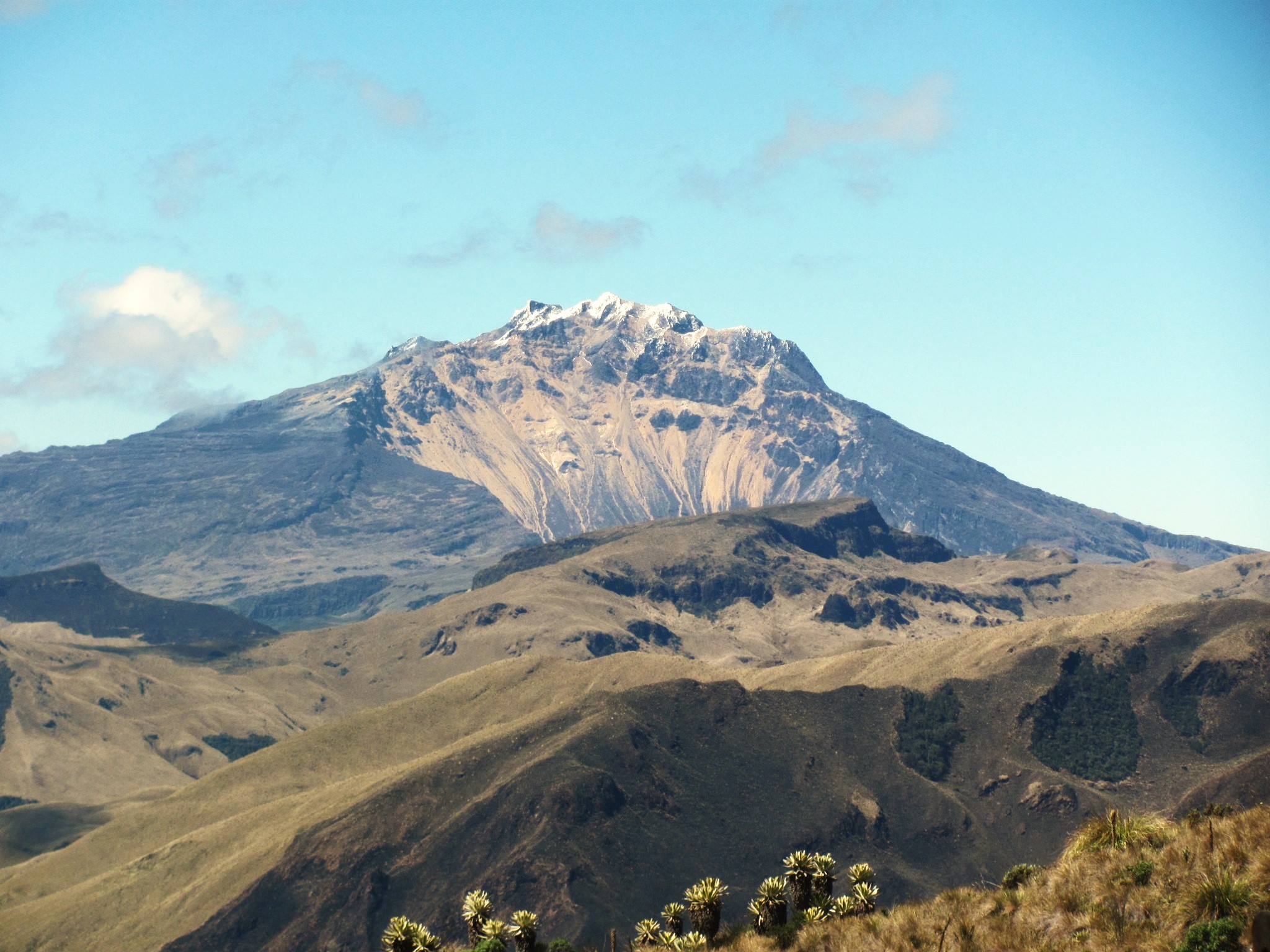
Colombia , Chiles / Cerro Negro :
San Juan de Pasto, June 3, 2025, 2:30 p.m.
According to monitoring of the activity of the Chiles-Cerro Negro Volcanic Complex (CVCCN), the Colombian Geological Survey (SGC), an entity affiliated with the Ministry of Mines and Energy, reports that:
From May 27 to June 2, 2025, the main variations in the monitored parameters compared to the previous week were:
● A significant decrease in seismic activity was observed; however, a slight increase in the energy released was recorded. The majority of earthquakes were associated with rock fractures within the volcanic edifice.
● Most of the earthquakes were concentrated 3.0 km west of the summit of Chiles Volcano and at depths between 2.0 and 5.0 km (relative to the reference elevation of 4,700 m). The largest seismic event, of magnitude 2.6, occurred 1.6 km west of the summit of Chiles Volcano, at a depth of 3.9 km and with no indication of any local population feeling. The remaining seismic activity was scattered throughout the CVCCN’s area of influence, at depths between 7.0 and 11.0 km.
● Analysis of information obtained from satellite sensors using InSAR measurements and permanent GNSS stations continues to indicate variations related to deformation processes in the volcanic zone. Based on the assessment of monitored parameters, the SGC recommends closely monitoring developments through weekly bulletins and other information published through our official channels, as well as instructions from local and departmental authorities and the National Disaster Risk Management Unit (UNGRD).
Volcanic activity remains on yellow alert: active volcano with changes in the baseline behavior of monitored parameters and other manifestations.
Source et photo : SGC.