May 27 , 2025.
Hawaii , Kilauea :
Sunday, May 25, 2025, 10:45 PM HST (Monday, May 26, 2025, 08:45 UTC)
19°25’16 » N 155°17’13 » W,
Summit Elevation 4091 ft (1247 m)
Current Volcano Alert Level: WATCH
Current Aviation Color Code: ORANGE
Activity Summary:
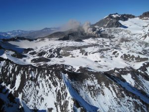
Episode 23 of the ongoing Halemaʻumaʻu eruption ended abruptly at 10:25 p.m. HST on Sunday, May 25.

Following an extended period of precursory low-level activity, episode 23 began yesterday at 4:15 p.m. with thin jets of lava erupting from the north vent that became sustained fountains by 4:25 p.m. Activity escalated quickly in the north vent with lava fountains reaching over 1,000 feet (300 meters) in height within 30 minutes. At 5:20 p.m., lava fountains began erupting from the south vent as well. South vent fountains grew rapidly and reached sustained heights of about 800 feet (250 meter) for much of the episode. Large lava flows erupted from both vents and covered about half of Halema’uma’u crater floor.
Seismic tremor intensified significantly at 4:36 p.m. as lava fountains became more robust in size and volume. This was accompanied by a rapid change in summmit tilt from inflation to deflation. Summit tiltmeters recorded rates of deflation over 2 microradian per hour during sustained fountaining.
Sulfur dioxide (SO2) emissions were estimated to be between 50,000-75,000 t/d, and based on webcam images from Mauna Loa summit, the plume reached well over 14,000 feet in height.
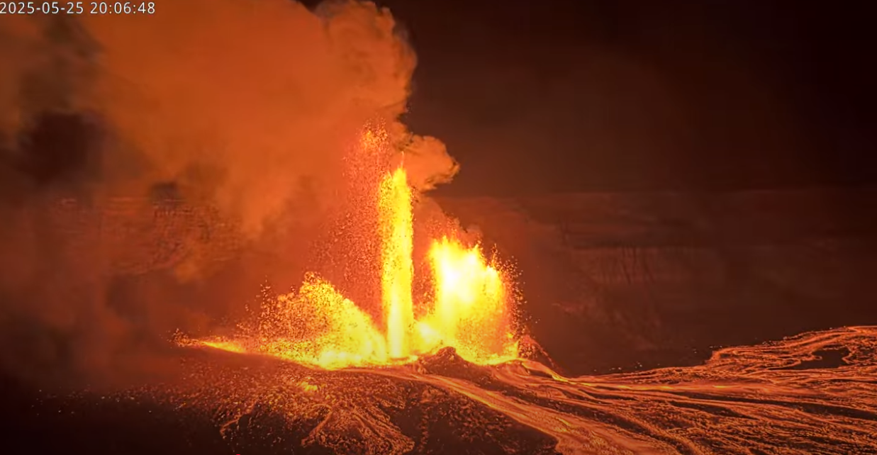
Fountaining began to wane when activity ceased in the north vent at 9:48 p.m. Episode 23 ended with the cessation of fountains and flows from the south vent at 10:25 p.m. The end of the eruption was coincident with a rapid change in summit tilt from deflation to inflation aling with a significant decrease in seismic tremor intensity. The Uēkahuna tiltmeter (UWD) recorded about 13 microradians of deflationary tilt during this episode.
Most episodes of Halemaʻumaʻu lava fountaining since December 23, 2024, have continued for around a day or less and have been separated by pauses in eruptive activity lasting generally at least several days.
No changes have been detected in the East Rift Zone or Southwest Rift Zone. HVO continues to closely monitor Kīlauea and will issue an eruption update tomorrow morning unless there are significant changes before then.
Kīlauea Volcano Alert Level/Aviation Color Code remain at WATCH/ORANGE. All current and recent activity is within Hawaiʻi Volcanoes National Park.
Source : HVO
Photos : USGS
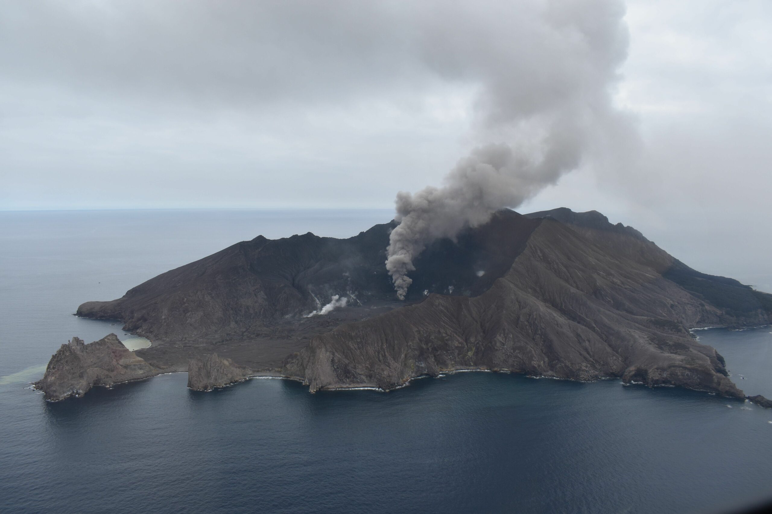
New Zealand , White Island :
Volcanic Activity Bulletin , Tue May 27 2025 10:00 AM.
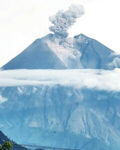
The emission of steam, gas and minor amounts of volcanic ash continues at Whakaari/ White Island but appears to be declining. While significant steam and gas plumes continue to be observed from the Bay of Plenty coast, no major ash emission have been detected from the land or satellite data over the past two weeks. The Volcanic Alert Level remains at 3 for now (minor volcanic eruption) and the Aviation Colour Code at Orange.
Web camera images over the last 2 weeks confirm a steam and gas plume from the active vent continues to be visible. But the presence of volcanic ash has been difficult to confirm. Over the same period, our colleagues at MetService have also not detected volcanic ash in the plume using satellite imagery, which suggest that if ash is still being emitted at the volcano, it is in lesser amount than over the previous weeks.
Due to weather, we were unable to complete gas and observation flights, during the last two weeks so have not been able to confirm the status of the active vent on the island and any substantial emission of ash. Satellite data did not record significant amounts of ash in the atmosphere over the same period, but smaller amount of ash could remain undetected by satellites. SO2 gas flux from the active vent at Whakaari/White Island remains moderate.
As conditions allow, we will conduct gas and observation flights to confirm if activity has decreased. Data collected include visual observations of the active vent morphology and activity, gas flux, and vent temperatures. Sulphur dioxide (SO₂) emissions remained monitored by satellite. The Te Kaha and Whakatāne web cameras continue to provide observations of the plumes’ status, but local weather conditions may impact how the activity appears from the Bay of Plenty coast.
Overall, steam and gas emissions appear to remain steady as they have been for the past few months, and the level of volcanic ash present may be declining. Due to our lack of on-island monitoring, it is possible that these conditions could change in the short term. Recent activity is consistent with minor yet potentially declining eruptive activity. As a result, the Volcanic Alert Level remains at 3 and the Aviation Colour Code at Orange. These levels acknowledge the ongoing volcanic activity but also reflect some of the uncertainty related to the current low level of monitoring.
Source : Geonet / Agnes Mazot / Duty Volcanologist
Photo : Geonet .
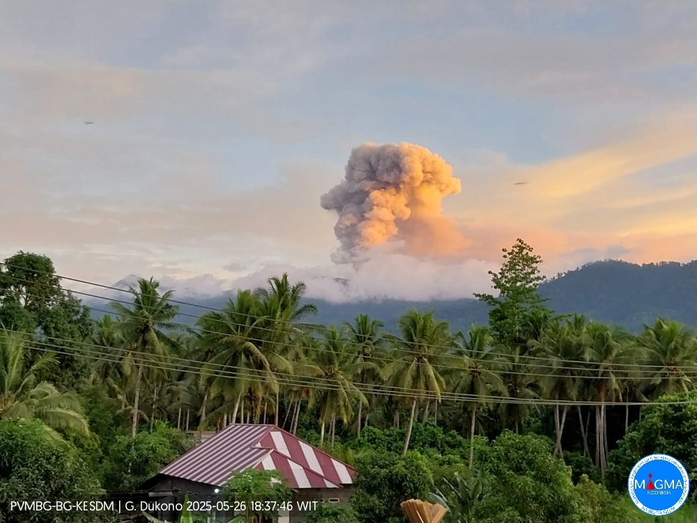
Indonesia , Dukono :
An eruption of Mount Dukono occurred on Monday, May 26, 2025, at 6:27 PM WIT with an observed ash column height of ± 1000 m above the peak (± 2087 m above sea level). The ash column was observed to be white to gray in color with a thick intensity, oriented toward the West. This eruption was recorded on a seismograph with a maximum amplitude of 22 mm and a duration of 65.38 seconds.
Seismicity Observation:
185 eruption earthquakes with an amplitude of 6 to 34 mm and a duration of 31.63 to 81.85 seconds.
1 distant tectonic earthquake with an amplitude of 24 mm and an earthquake duration of 71.6 seconds.
1 continuous tremor earthquake with an amplitude of 2-5 mm, with a dominant value of 3 mm.
Recommendation
(1) People around Mount Dukono and visitors/tourists should not engage in activities, climb, or approach the Malupang Warirang crater within a 4 km radius. (2) Since volcanic ash eruptions occur periodically and the distribution of ash follows the direction and speed of the wind, so the area where the ash lands is not constant, people around Mount Dukono are recommended to always carry masks/nose and mouth covers to use when needed to avoid the threat of volcanic ash to the respiratory system.
Source et photo : Magma Indonésie .
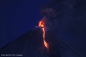
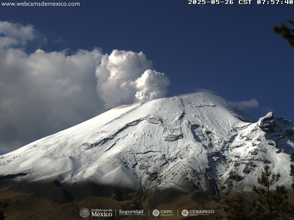
Mexico, Popocatepetl :
May 26, 11:00 AM (May 26, 5:00 PM GMT), Activity over the past 24 hours
37 low-intensity exhalations were detected, accompanied by water vapor, other volcanic gases, and occasional light amounts of ash, and 161 minutes of low-amplitude tremor.
At the time of writing, visibility is partial due to cloud cover in the area. However, in the early morning hours, a continuous emission of water vapor and other volcanic gases was observed in an east-southeast (ESE) direction.
The Popocatépetl volcano fire alert is at yellow phase 2.
The scenarios predicted for this phase are:
A few minor to moderate explosions
Occurrence of tremors of varying amplitude
Light to moderate ashfall in surrounding towns and some more distant towns
Ejection of incandescent fragments within a 12-kilometer exclusion radius
Lahars could tumble down ravines due to ash accumulation on the slopes and their interaction with the rains expected in the coming weeks.
Possibility of pyroclastic flows not affecting populations
Source et photo : Cenapred .
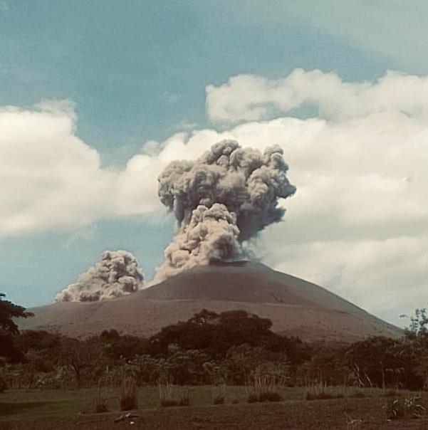
Nicaragua , Telica :
Telica, one of Nicaragua’s most active volcanoes, erupted on May 24, sending gas, ash, and rocks 600 meters into the air. Ineter is monitoring the volcano while nearby communities remain on alert.
The direction of the eruption was southwest, potentially affecting nearby communities.
According to preliminary reports from local authorities and volcano monitoring specialists, the eruptive activity was concentrated specifically in the volcano’s crater. The expulsion of incandescent material was observed simultaneously with the dense ash cloud, which was carried by the winds.
So far, authorities have not reported any material damage or casualties as a result of this event. However, the population, particularly those living in the areas surrounding the volcano, has been advised to remain vigilant and take necessary precautions.
The Nicaraguan Institute of Territorial Studies (INETER) indicated that it continues to closely monitor Telica’s activity to assess any changes in its behavior and issue timely alerts if the situation requires it.
The Telica volcano, 1,061 meters high and located 112 kilometers northwest of Managua, has recorded emissions of gas and water vapor over the past 72 hours, without causing any damage or casualties, authorities reported Tuesday.
Sources : Ineter , 100% Noticias .
Photo : Radio 580 Nicaragua .