May 26 , 2025.
Hawaii , Kilauea :
Sunday, May 25, 2025, 5:33 PM HST (Monday, May 26, 2025, 03:33 UTC)
19°25’16 » N 155°17’13 » W,
Summit Elevation 4091 ft (1247 m)
Current Volcano Alert Level: WATCH
Current Aviation Color Code: ORANGE
Activity Summary:
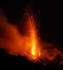
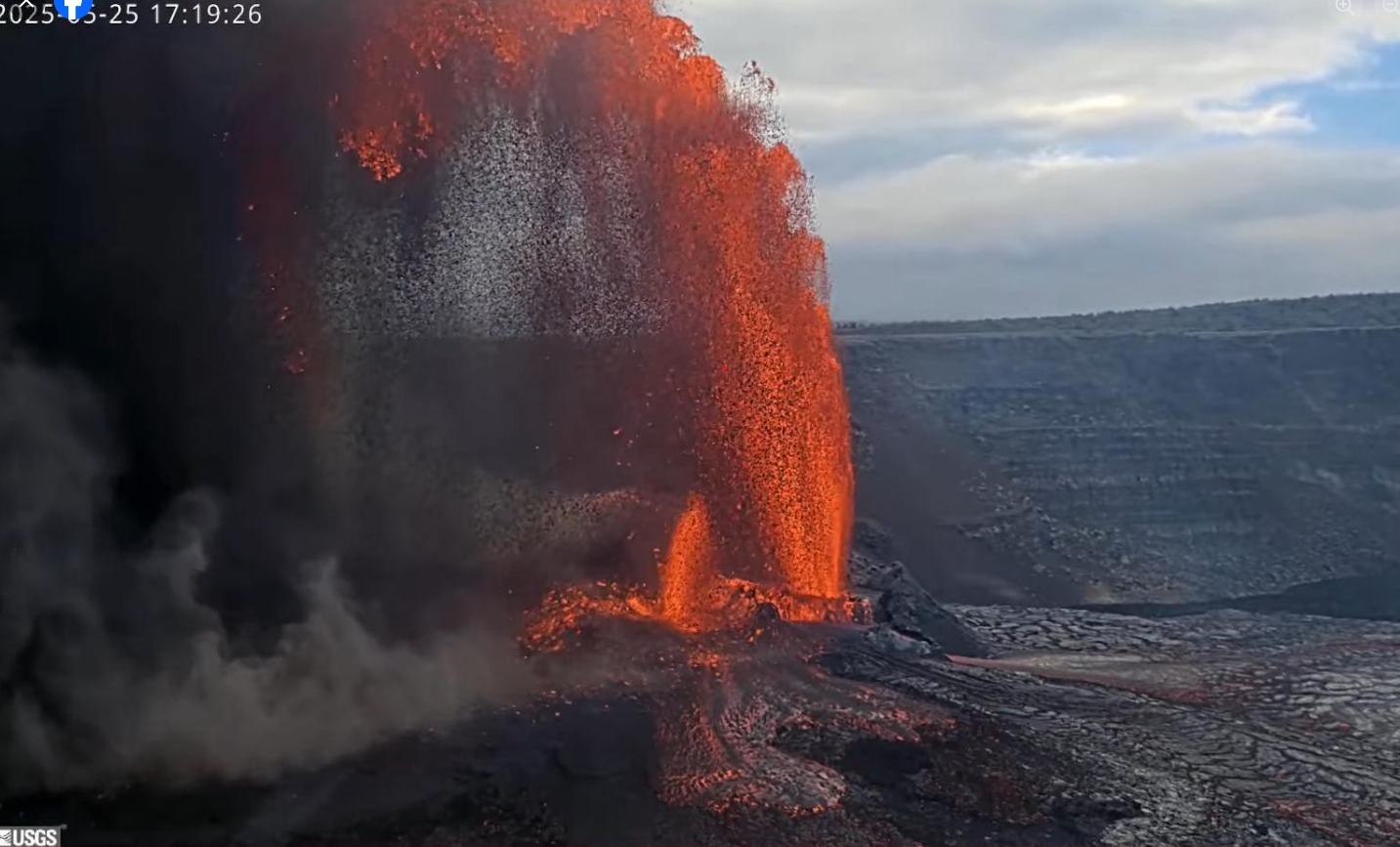
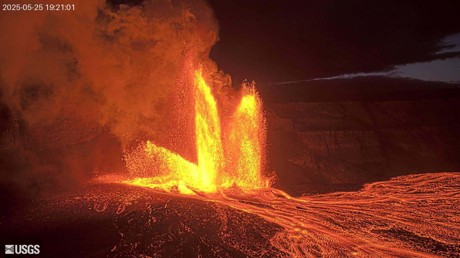
Episode 23 of the ongoing Halemaʻumaʻu eruption began at 4:15 p.m. HST on May 25 with the onset of sustained lava fountains. Lava flows are covering the floor of Halema’uma’u crater. Activity began in the north vent, which escalated to high fountains by 4:50 p.m. The south vent followed with smaller fountains by 5:15 p.m. As of 5:20 p.m., lava fountains from the south vent are about 230 feet (70 meters) in height while lava fountains from the north vent are exceeding 1,000 feet (300 meters) in height.
Inflationary tilt at UWD reached just over 12 microradians since the end of the last episode and changed quickly to deflation when sustained fountaining began. Seismic tremor began increasing at 4:36 p.m. at the same time that fountaining increased in height and volume.
Sulfur dioxide (SO2) emission rates are estimated to be approximately 50,000 t/d during fountaining events.
Most episodes of Halemaʻumaʻu lava fountaining since December 23, 2024, have continued for around a day or less and have been separated by pauses in eruptive activity lasting generally at least several days.
No changes have been detected in the East Rift Zone or Southwest Rift Zone. HVO continues to closely monitor Kīlauea and will issue an eruption update tomorrow morning unless there are significant changes before then.
Kīlauea Volcano Alert Level/Aviation Color Code remain at WATCH/ORANGE. All current and recent activity is within Hawaiʻi Volcanoes National Park.
Source : HVO.
Photos : USGS
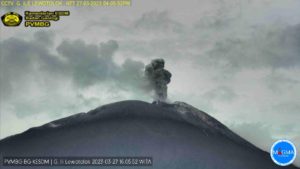
Indonesia , Ili Lewotolok :
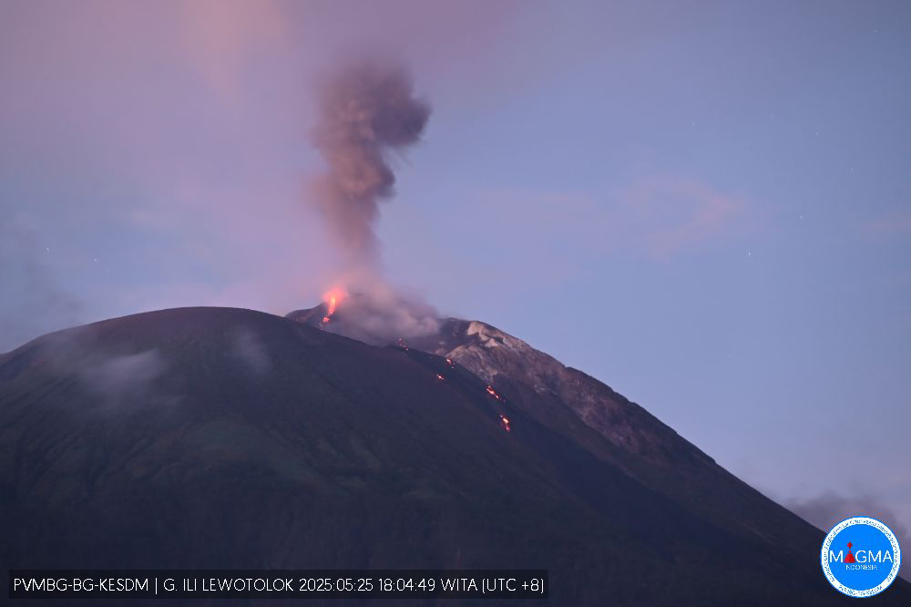
An eruption of Mount Ili Lewotolok occurred on Sunday, May 25, 2025, at 6:19 PM WITA with an observed ash column height of ± 100 m above the peak (± 1523 m above sea level). The ash column was observed to be white to gray in color with a thick intensity, oriented toward the West. This eruption was recorded on a seismograph with a maximum amplitude of 38 mm and a duration of 60 seconds.
Seismicity Observation:
106 eruption earthquakes with an amplitude of 15.2 to 48.6 mm and a duration of 42 to 60 seconds.
142 emission earthquakes with an amplitude of 1.9 to 23.3 mm and a duration of 27 to 37 seconds.
23 harmonic tremors with an amplitude of 3.3 to 9.3 mm and an earthquake duration of 90 to 212 seconds.
3 deep volcanic earthquakes with an amplitude of 3.1 to 40 mm and an earthquake duration of 11 to 26 seconds.
2 local tectonic earthquakes with an amplitude of 1.6 to 19.5 mm and an earthquake duration of 24 to 32 seconds. One distant tectonic earthquake with an amplitude of 1.9 mm and an earthquake duration of 62 seconds.
Recommendation
At Activity Level II (Alert), it is recommended:
(1) The community around Mount Ili Lewotolok and visitors/climbers/tourists should not enter or conduct activities within a 2 km radius of the activity center of Mount Ili Lewotolok, and the community of Lamatokan Village and Jontona Village should always be aware of the potential threat of lahars/landslides originating from the eastern part of the summit/crater of Mount Ili Lewotolok. (2) The community around Mount Ili Lewotolok, as well as visitors/climbers/tourists and the community of Jontona Village and Todanara Village should not enter and carry out activities in the South and Southeast sectoral areas within 2.5 km of the activity center of Mount Ili Lewotolok, and should be aware of the potential threat of danger from lava avalanches/landslides originating from the South and Southeast parts of the summit/crater of Mount Ili Lewotolok.
Source et photo : Magma Indonésie .
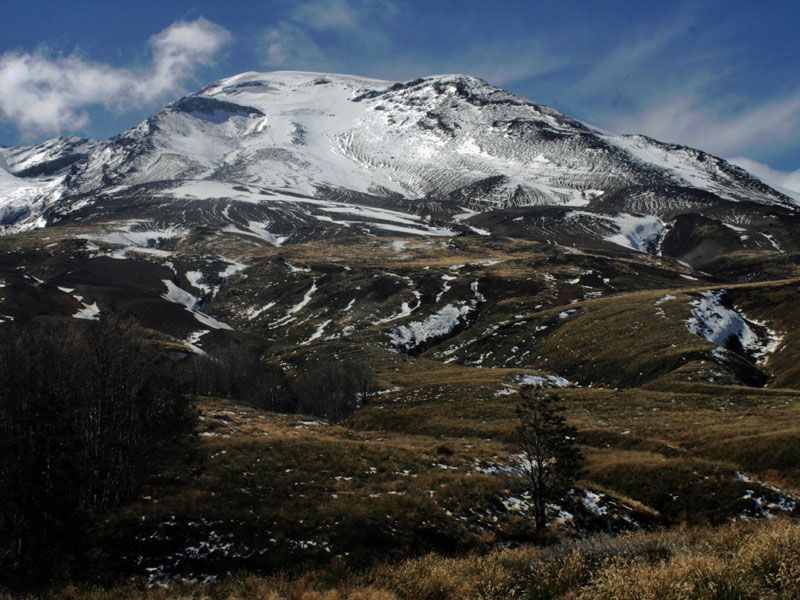
Chile , Puyehue / Cordon Caulle :
Seismology
The seismological activity for the period was characterized by the recording of:
265 VT-type seismic events, associated with rock fracturing (Volcano-Tectonic). The most energetic earthquake had a local magnitude (LM) value of 2.5, located 5.0 km to the south-southwest and with a depth of 4.7 km from the 2011 emission center.
2 LP-type seismic events, associated with fluid dynamics within the volcanic system (Long Period). The size of the largest earthquake, estimated using the reduced displacement (RD) parameter, was 5 cm².
Fluid Geochemistry
No anomalies in sulfur dioxide (SO2) emissions into the atmosphere have been reported in the area near the volcanic complex, according to data published by the Tropospheric Monitoring Instrument (TROPOMI) and the Sulfur Dioxide Group of the Ozone Monitoring Instrument (OMI).
Geodesy
Based on data obtained from GNSS stations deployed in the volcanic complex, it is observed that the uplift process of the center of the Cordón Caulle graben is continuing. The horizontal displacement rate recorded over the last 30 days is 0.7 cm/month, while the maximum uplift rate is 1.3 cm/month. Using Sentinel 1A radar images and radar interferometry, we observe that the inflation process of the graben area continues, with minimal variations in the uplift pattern, which is consistent with the aforementioned results regarding GNSS data.
Furthermore, GNSS stations installed in February 2025 at distances less than 1 km from the emission center of the 2011 eruption maintain a negative vertical displacement with a maximum rate of -2.6 cm/month, indicating subsidence in this area near the emission center.
Satellite Thermal Anomalies
During the period, no thermal alerts were recorded in the volcanic complex, according to data processed by VIIRS and MODIS sensors from the Mid-Infrared Volcanic Activity Observation Platform (MIROVA), as well as analytical processing of Sentinel 2-L2A satellite images, in a combination of false-color bands.
Surveillance Cameras
Images provided by fixed cameras installed near the volcanic complex did not record any degassing plumes or variations associated with surface activity.
Satellite Geomorphological Analysis
Based on observations from Planet Scope Scene and Sentinel 2-L2A satellite images, no morphological changes related to volcanic activity were identified.
The activity of the volcanic complex shows no significant changes compared to the previous two weeks. The deformation process continues with a constant inflationary trend and a stable rate. Similarly, other monitoring parameters, including volcano-tectonic seismicity, show no significant variations, with the exception of occasional slight fluctuations. Therefore, the system’s behavior is considered to remain within recently observed ranges, and the technical volcanic alert remains at:
YELLOW TECHNICAL ALERT: Changes in the behavior of volcanic activity.
Source : Sernageomin .
Photo : Huella Andina Expeditions
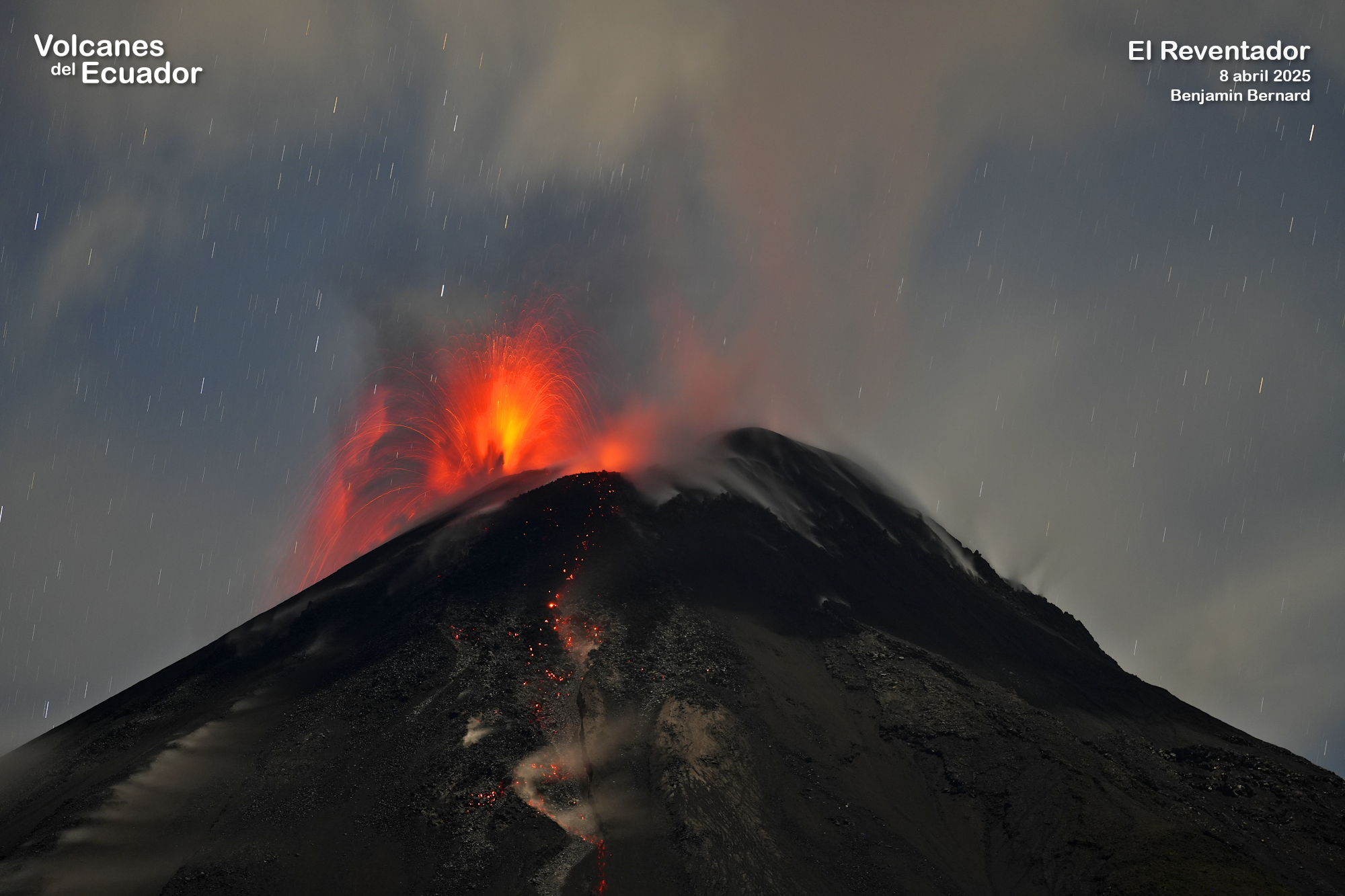
Ecuador , El Reventador :
DAILY STATUS REPORT OF REVENTADOR VOLCANO, Sunday, May 25, 2025.
Information Geophysical Institute – EPN.
Surface Activity Level: High, Surface Trend: No change
Internal Activity Level: Moderate, Internal Trend: No change
From May 24, 2025, 11:00 a.m. to May 25, 2025, 11:00 a.m.:
Seismicity:
Below is the count of seismic events recorded at the reference station.
Explosion (EXP) 96
Long Period (LP) 12
Emission Tremor (TREMI) 26
Harmonic Tremor (TRARM) 5
Rainfall/Lahars:
Light rain was recorded in the volcano area last night and early this morning, according to surveillance cameras and meteorologists. **If heavy rains occur in the region, they could remobilize accumulated material and generate mud and debris flows that would descend the volcano’s flanks and flow into downstream rivers.
Emission/Ash Column:
Since yesterday, no gas or ash emissions have been observed using surveillance cameras and satellite images. In connection with this low activity, the Washington-based VAAC agency issued an activity report on small bursts with a light load of gas and ash that reached 1,100 m above the crater in a westerly direction.
Other monitoring parameters:
Thanks to the FIRMS satellite system, two thermal alerts were recorded in the last 24 hours.
Observation:
Over the past 24 hours, several episodes of incandescent material falling down the flanks of the volcano have been observed, reaching up to 1,000 meters below the crater level.
However, the volcano remained cloudy most of the time.
Alert Level – SGR: Orange
Source : IGEPN
Photo : Benjamin Bernard via volcanes ecuador / FB. ( 08/04/2025)
Guatemala , Santiaguito :
Weather conditions: Clear.
Wind: Southeast.
Precipitation: 75.0 mm.
Activity:
The Santa María-Santiaguito Volcanic Complex Observatory reports favorable atmospheric conditions for observing the Caliente Dome. Degassing is occurring, raising columns of magmatic gases to heights of 600 meters above the crater level.

Between one and two weak to moderate explosions per hour are reported, which also generate columns of gas accompanied by ash, which can reach heights of 800 meters above the crater level. The latter are moved westward by the wind direction, which is why light ashfall is expected on Monte Bello, Loma Linda, Monte Maria and the surrounding areas. Activity remains high, so it is possible that due to explosions or the effects of gravity, some of the accumulated material could collapse and generate large-scale pyroclastic flows towards the southwest, south and southeast. For these reasons, the recommendations described in special bulletin BESAN-002-2025 should be followed.
Source : Insivumeh .
Photo : Armando Pineda