May 13 , 2025.
Philippines , Kanlaon :
KANLAON VOLCANO ERUPTION BULLETIN 13 May 2025 04:30 AM
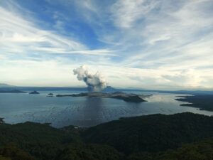
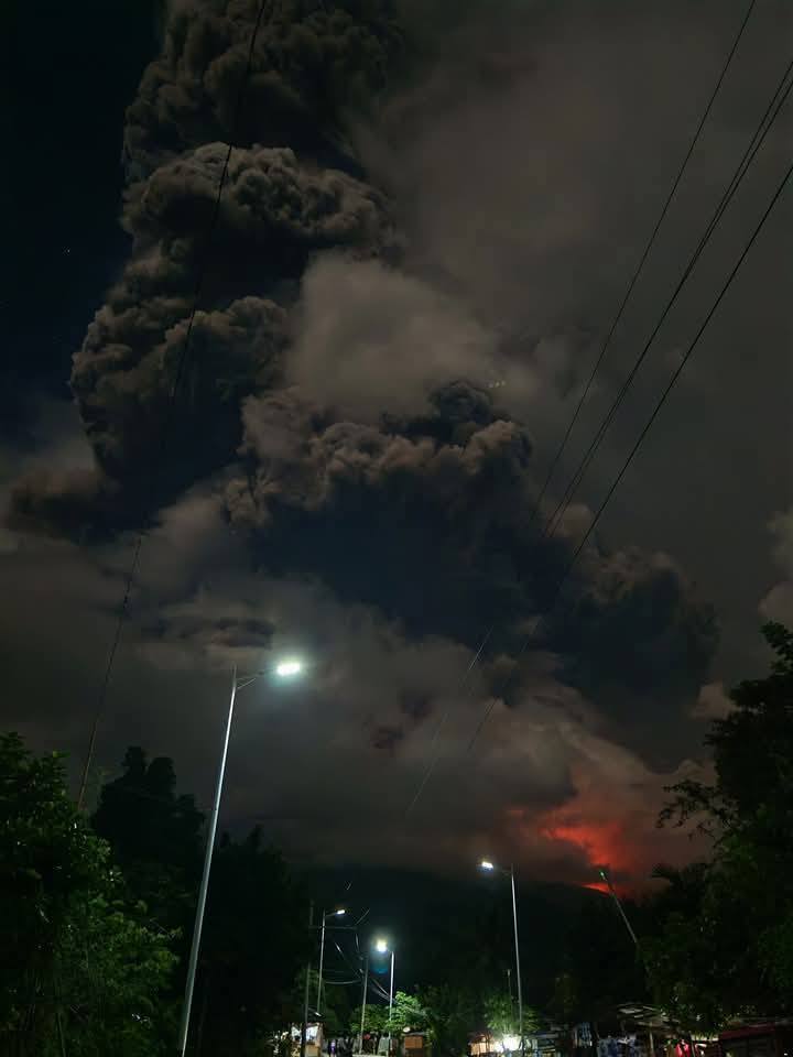
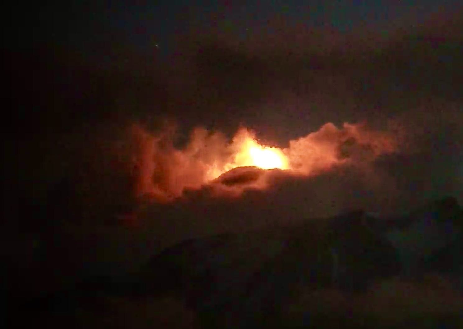
A moderately explosive eruption occurred at the summit crater of Kanlaon Volcano at 02:55 AM today, 13 May 2025, that lasted five (5) minutes based on seismic and infrasound data. The eruption generated a greyish voluminous plume that rose approximately 4.5 kilometers above the vent before drifting to the southwest. Audible rumbling sounds of the eruption were reported in Brgy. Pula, Canlaon City, Negros Oriental and La Castellana, Negros Occidental. Incandescent pyroclastic density currents or PDCs descended the southern slopes within approximately two (2) kilometers of the crater based on visual and thermal camera monitoring. Large ballistic fragments were also observed to have been thrown around the crater within a few hundred meters and caused burning of vegetation near the volcano summit. Thin ashfall has been reported in the following localities of Negros Occidental: La Carlota City– Brgys. Cubay, San Miguel, Yubo and Ara-al; Bago City– Brgys. Ilijan and Binubuhan, and; La Castellana– Brgys. Biak-na-Bato, Sag-ang, and Mansalanao.
Alert Level 3 (magmatic unrest) prevails over Kanlaon, which means that the volcano is in a state of magmatic unrest, with currently increased chances of short-lived moderately explosive eruptions that could generate life-threatening volcanic hazards. It is recommended that communities within a 6-km radius from the summit crater remain evacuated due to the danger of pyroclastic density currents or PDCs, ballistic projectiles, ashfall, rockfall and other related hazards. Communities that experience ashfall must take all necessary precautions and use protective masks or wet cloth to prevent ash inhalation, with special attention given to vulnerable persons including the elderly, persons with respiratory or cardio-vascular diseases, expecting mothers and infants. Local government units must continue to prepare their communities within the PDC hazard zone for subsequent evacuation in case unrest further escalates and hazardous worst-case explosive eruption becomes imminent. Increased vigilance against potential syn-eruption lahars and sediment-laden streamflows in channels draining the edifice is strongly advised should intense rains occur during eruptive unrest. Civil aviation authorities must also advise pilots to avoid flying close to the volcano’s summit as ash from any sudden eruption can be hazardous to aircraft.
DOST-PHIVOLCS maintains close monitoring of Kanlaon Volcano and any new development will be immediately communicated to all concerned stakeholders.
Source : DOST-PHIVOLCS
Photo : Byahe Ni Balbon
Italy / Sicily , Etna :
May 12, 2025, 9:06 PM (7:06 PM UTC) STATEMENT ON ETNA ACTIVITY
The National Institute of Geophysics and Volcanology, Osservatorio Etneo, reports that starting at 6:30 PM UTC, following the thinning of the cloud cover that persists over the volcano, Strombolian activity can be observed from surveillance cameras in the Southeast Crater. The forecast model indicates that any eruptive clouds produced by the ongoing activity would disperse in an east-southeast direction. The presence of cloud cover limits the observation of details of the ongoing activity.
From a seismic perspective, starting around 11:00 UTC, the average amplitude of volcanic tremor showed a gradual increase and reached the high range around 18:00 UTC. Currently, the values are high, with a tendency to increase further. The centroid of the tremor sources is located in the southeast crater area at an altitude of approximately 2,800 m above sea level. From around 18:30 UTC, very modest infrasound activity was recorded, characterized by very low-amplitude infrasound events.
Ground deformation monitoring networks do not currently show any significant variations.
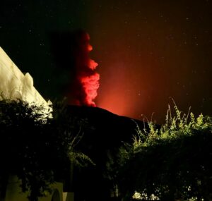
ETNA ACTIVITY STATEMENT May 12, 2025, 11:54 PM (9:54 PM UTC)
The National Institute of Geophysics and Volcanology, Osservatorio Etneo, reports that intense and frequent explosions from the Southeast Crater continue. The eruptive activity is feeding two small lava flows directed south and east respectively. The eruptive cloud is dispersing in an east-southeast direction; Ashfall has been reported at Zafferana Etnea.
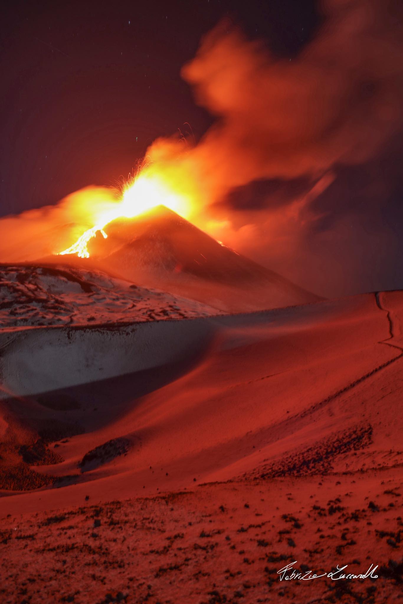
From a seismic perspective, the average amplitude of the volcanic tremor reached its maximum value around 20:10 UTC and is currently still at high values. The centroid of the tremor sources is located in the Southeast Crater area at an altitude of approximately 2,900 m above sea level. Infrasound activity is high in terms of both occurrence rate and energy of the events, which are located in correspondence with the Southeast Crater.
Deformation data from monitoring networks do not show any significant variations. At the time of writing, the eruptive phenomenon recorded a modest variation of approximately 24 nano-strains on the dilatometer at the DRUV station.
Further updates will be provided shortly, and in any case within 3 hours of this press release.
Source : INGV
Photos : Webcam , Fabrizio Zuccarello • Volcano Guide
New Zealand , White Island :
Volcanic Activity Bulletin , Tue May 13 2025 9:15 AM;
Volcanic Alert Level remains at 3
Aviation Colour Code remains at Orange
The emission of steam, gas and minor amounts of volcanic ash continues at Whakaari/White Island. Ash plumes from the active vent have been ob-served during recent observation and gas flights. Due to this ongoing volcanic activity, the Volcanic Alert Level remains at Level 3 and the Aviation Colour Code at Orange.
Minor amounts of volcanic ash were observed in the steam and gas plume from the active vent during our recent monitoring flights near Whakaari/White Island. Over the same period, our colleagues at MetService detected minor amounts of volcanic ash in the plume using satellite imagery. Depending on the wind strength and direction, this can be seen from the Bay of Plenty coast and webcams at Whakatāne and Te Kaha, either as a hazy plume trailing downwind from the volcano or as a vertical plume above the volcano. The Volcanic Alert Level remains at Level 3 (minor volcanic eruption).
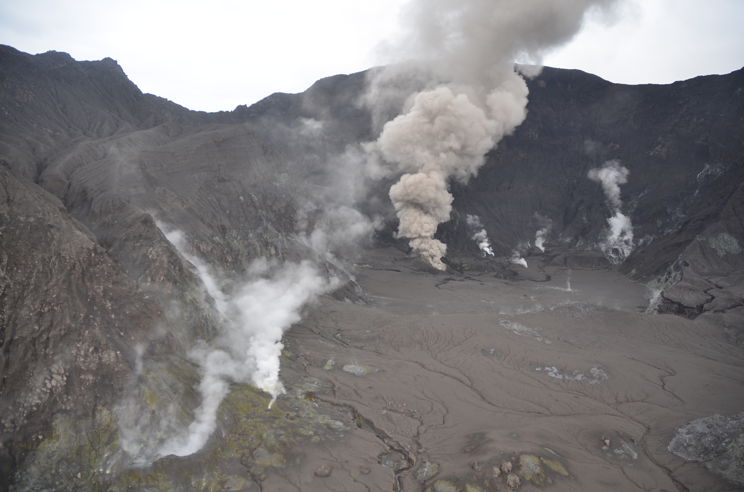
Aerial views of Whakaari/White Island on 6 May 2025 showing ash emission from the active vent that is feeding the steam and gas plume.
Recent gas and observation flights, and satellite data, have confirmed that there is now near continuous emission of small amounts of volcanic ash from the active vent at Whakaari/White Island . Local weather conditions have a significant impact on how the activity appears when viewed from the Bay of Plenty coast. Under calm conditions the volcanic plume can rise to 1-2000 ft (~300 – 600 m) above the volcano, but as the wind speed increases the plume height decreases, and a long hazy plume can be seen trailing off downwind for tens of kilometres .
The volcanic ash emissions remain relatively steady from the active vent, which has not changed much in size or shape. The Wellington VAAC (Volcanic Ash Advisory Centre) has issued several advisories for the airborne volcanic plume that can encroach into active aviation airspace. This has resulted in some flight cancellations due to aviation regulations and airline policy. However, it is important to note that while the volcanic plume has at times travelled above the Bay of Plenty coast, the amount of ash it carries remains very small and is not expected to fall back on the mainland; minor ash fall is observed on or near the island itself.
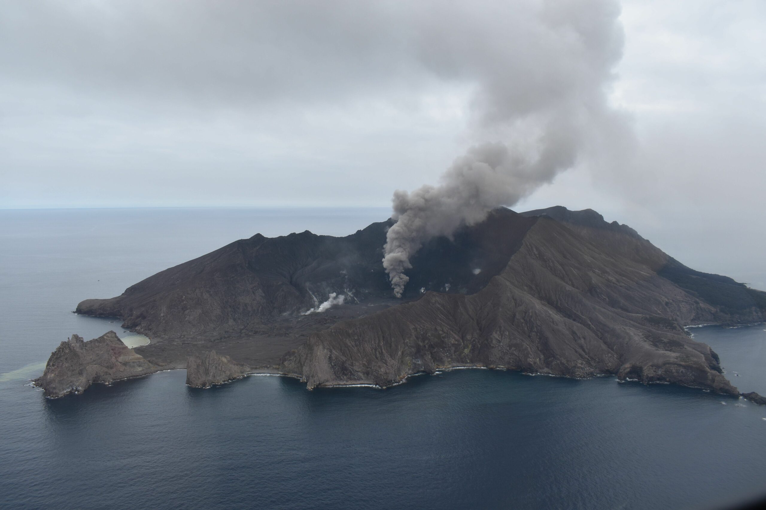
Aerial view of Whakaari/White Island on 6 May 2025 showing the steam and gas plume trailing off downwind.
Monitoring data from our gas flights, thermal infrared temperature measurements and the sulphur dioxide (SO₂) emissions detected by satellite, are consistent with the previously observed levels of volcanic activity, including steady ash emissions. The amount of volcanic gas emitted is steady, while the vent temperatures have increased to around 460 °C; this is still below the temperatures of up to 650 °C measured in 2020 and 2021. Minor night glow at the volcano has also been captured by the Te Kaha camera and is consistent with the higher vent temperatures; this ‘glow’ is only visible in the near infra-red with our camera and unlikely to be visible with the naked eye. During recent observation flights, we have noticed a decrease in new impact craters near the vent, indicating less explosive activity.
Steam, gas, and volcanic ash emissions remain steady as they have been for the past few months. Due to our lack of on-island monitoring, it is possible that short-duration eruptions are occurring without being directly recorded. Recent activity is consistent with minor eruptive activity and therefore, the Volcanic Alert Level remains at Level 3. The continued presence of volcanic ash emissions mean that the Aviation Colour Code remains Orange. These levels acknowledge the ongoing volcanic activity but also reflect some of the uncertainty related to the current low level of monitoring.
Source et photos : Geonet / Oliver Lamb / Duty Volcanologist
Hawaii , Kilauea :
HAWAIIAN VOLCANO OBSERVATORY STATUS REPORT , U.S. Geological Survey
Sunday, May 11, 2025, 8:54 PM HST (Monday, May 12, 2025, 06:54 UTC)
19°25’16 » N 155°17’13 » W,
Summit Elevation 4091 ft (1247 m)
Current Volcano Alert Level: WATCH
Current Aviation Color Code: ORANGE
Activity Summary:
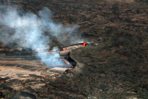
Episode 21 ended at 08:34 p.m. HST on Tuesday, May 11, 2025, after ~8 hours of sustained fountaining. The Halema’uma’u eruption is currently paused.
The sustained fountaining phase of episode 21 began at 12:45 p.m. on Sunday, May 11, 2025. Lava fountains and flows erupted primarily from the north vent, and the south vent was largely obscured by the north vent activity. Fountains from the north vent quickly reached estimated heights of more than 500 feet (150 meters). Lava flows from this episode inundated the near vent and extended more than a km along the north edge of the Halema’um’au crater floor. The sustained fountaining phase was preceded by the onset of small fountain events at 4:30, 5:20 and 8:00 a.m. after which numerous small fountains were observed. The precursory low-level activity included gas-pistoning and fountains some of which included modest lava pond drainback.
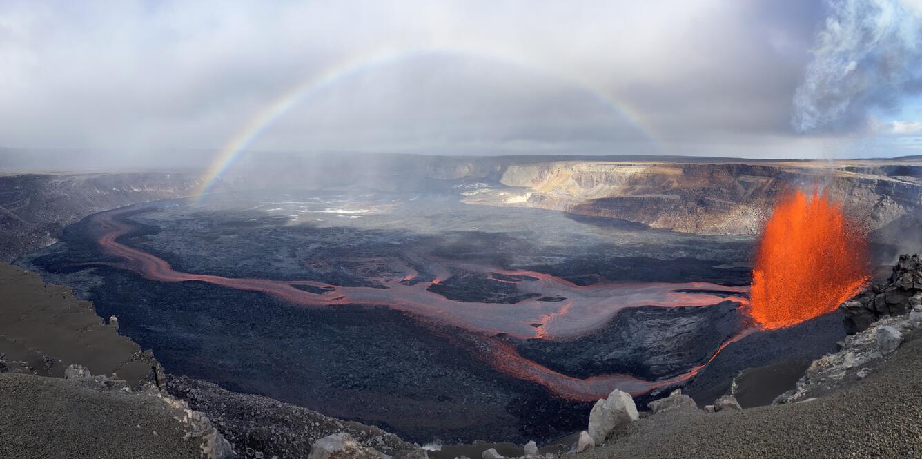
While visiting the western rim of Halemaʻumaʻu on May 11, USGS Hawaiian Volcano Observatory scientists watched an ānuenue (rainbow) stretch across the crater during episode 21 of the ongoing Kīlauea summit eruption. Lava fountains from the northern eruptive vent (right) were feeding extensive lava flows on the crater floor at the time.
The end of episode 21 fountaining activity was accompanied by a rapid change in summit tilt from deflation to inflation, along with a rapid decrease in tremor. The Uēkahuna tiltmeter (UWD) recorded approximately 6 microradians of deflationary tilt between the start and end of episode 21 fountaining.
Kīlauea’s current eruption in Halemaʻumaʻu crater within Kaluapele (the summit caldera) began on December 23, 2024. There have now been 21 episodes separated by pauses in activity. All eruptive activity remains within Hawaiʻi Volcanoes National Park. No significant activity has been noted along Kīlauea’s East Rift Zone or Southwest Rift Zone. Current hazards include volcanic gas emissions and windblown volcanic glass (Pele’s hair) and tephra that have impacted Hawaiʻi Volcanoes National Park and nearby communities.
Each episode of Halemaʻumaʻu lava fountaining since December 23, 2024, has continued for13 hours to 8 days and episodes have been separated by pauses in eruptive activity lasting less than 24 hours to 12 days.
No changes have been detected in the East Rift Zone or Southwest Rift Zone. HVO continues to closely monitor Kīlauea and will issue an eruption update tomorrow morning unless there are significant changes before then.
Kīlauea Volcano Alert Level/Aviation Color Code remain at WATCH/ORANGE. All current and recent activity is within Hawaiʻi Volcanoes National Park.
Source : HVO
Photo : USGS / M. Zoeller.
Philippines , Bulusan :
BULUSAN VOLCANO ADVISORY ,12 May 2025 , 1:30 PM
Notice of increased seismic activity at Bulusan Volcano.
A total of three-hundred nine (309) volcanic earthquakes were recorded by Bulusan Volcano Network (BVN) since 12AM of 08 May 2025. Of these, two-hundred eighty-seven (287) were volcano-tectonic (VT) earthquakes associated with rock fracturing occurring at shallow depth less than 4 kilometers beneath the southeastern edifice of Bulusan Volcano and twenty-two (22) were low frequency volcanic earthquake (LFVQ) associated with movement of fluid. Degassing activity from the active vents have been weak to moderate when the volcano is visible for the past days. These changes in parameters may indicate shallow hydrothermal activity of Bulusan Volcano.
Alert Level 1 (low-level unrest) is maintained over Bulusan Volcano, which means that there are increased chances of phreatic eruptions. Local government units and the public are reminded that entry into the 4-kilometer radius Permanent Danger Zone (PDZ) must be strictly prohibited and that vigilance in the 2-kilometer Extended Danger Zone (EDZ) on the southeast sector must be exercised due to the possible impacts of volcanic hazards such as pyroclastic density currents or PDCs, ballistic projectiles, rockfall, avalanches, ashfall and others on these danger areas. Communities that experience ashfall must take all necessary precautions and use protective masks or wet cloth to prevent ash inhalation, with special attention given to vulnerable persons including the elderly, persons with respiratory or cardio-vascular diseases, expecting mothers and infants. Civil aviation authorities must also advise pilots to avoid flying close to the volcano’s summit as ash from any sudden phreatic eruption can be hazardous to aircraft. Furthermore, people living within valleys and along river/stream channels especially on the western sectors of the edifice should be vigilant against sediment-laden stream flows and lahars in the event of heavy and prolonged rainfall should phreatic eruption occur.
DOST-PHIVOLCS is closely monitoring Bulusan Volcano’s condition and any new development will be relayed to all concerned.
Source et photo : DOST-PHIVOLCS