MaY 07 , 2025 .
Hawaii , Kilauea :
Tuesday, May 6, 2025, 6:23 PM HST (Wednesday, May 7, 2025, 04:23 UTC)
19°25’16 » N 155°17’13 » W,
Summit Elevation 4091 ft (1247 m)
Current Volcano Alert Level: WATCH
Current Aviation Color Code: ORANGE
Activity Summary:
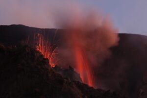
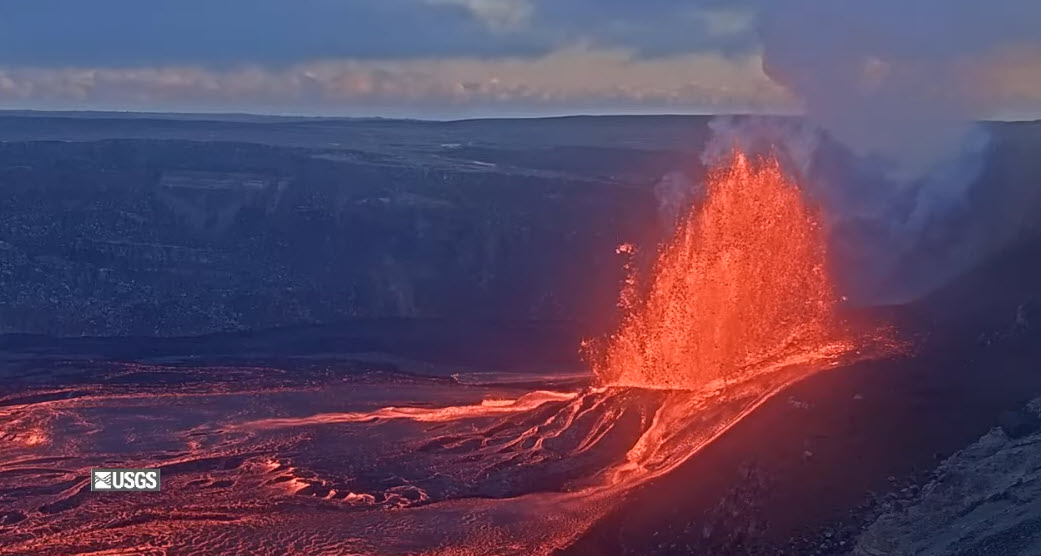
Episode 20 sustained lava fountaining began at 5:28 p.m. HST on May 6, 2025, as north vent cyclic gas-pistoning transitioned to continuous eruption of lava fountains that grew rapidly in vigor and height. Fountains from the north vent quickly reached heights of greater than 500 ft (150 m). North vent lava fountains are feeding fast moving lava flows that are covering the floor of Halema’uma’u crater, including a flow that poured over the south vent. The south vent is not showing signs of increased activity at this time.
The onset of sustained fountaining was accompanied by a rapid change in summit tilt from inflation to deflation along with a rapid increase in tremor. The Uēkahuna tiltmeter (UWD) recorded approximately 8 microradians of inflationary tilt between the end of episode 19 and the beginning of episode 20 sustained fountaining.
Episode 20 sustained fountaining was preceded by just under 31 hours of precursory low-level activity that included gas-pistoning events in the north vent that produced low lava dome fountains, overflows, and drainbacks, as well as sluggish lava flows from the south vent.
Each episode of Halemaʻumaʻu lava fountaining since December 23, 2024, has continued for 13 hours to 8 days and episodes have been separated by pauses in eruptive activity lasting less than 24 hours to 12 days.
No changes have been detected in the East Rift Zone or Southwest Rift Zone. HVO continues to closely monitor Kīlauea and will issue an eruption update tomorrow morning unless there are significant changes before then.
Kīlauea Volcano Alert Level/Aviation Color Code remain at WATCH/ORANGE. All current and recent activity is within Hawaiʻi Volcanoes National Park.
Source et photo : HVO
Italy / Sicily , Etna :
WEEKLY BULLETIN, from April 28, 2025 to May 4, 2025 (publication date May 6, 2025)
ACTIVITY STATUS SUMMARY
Based on monitoring data, the following is highlighted:
1) VOLCANOLOGICAL OBSERVATIONS: Eruptive episode with fountaining and lava flows at the Southeast Crater on April 30. Degassing of the summit craters.
2) SEISMOLOGICAL: Absence of seismic activity due to fracturing with Ml>=2.0; tremor amplitude ranged from medium-low to high levels recorded during the lava fountaining episode at the Southeast Crater.
3) INFRASOUND: Moderate infrasound activity. 4) GROUND DEFORMATION: Ground deformation monitoring networks did not record any significant changes, except for slight variations in tilt/deformation during the April 30th activity.
5) GEOCHEMISTRY: SO2 flux at medium-low levels, medium-high values on April 30th.
Soil CO2 flux: medium-low values.
Dissolved CO2 partial pressure in groundwater: slightly increasing values.
Helium isotope ratio at peripheral sites: last updated on April 22, 2025, at medium-high values. 6) SATELLITE OBSERVATIONS: Thermal activity observed by satellite in the summit area was generally low, with high to very high values corresponding to the eruptive activity of the Southeast Crater on April 29, 2025, and May 5, 2025.
7) OTHER OBSERVATIONS: Analysis of the magma composition indicates that at the end of April, there was more primitive magma in the magma « reservoir » of the Southeast Crater than that previously emitted.
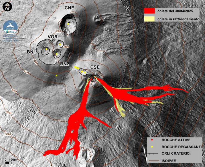
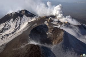
Map of the summit area of Mount Etna and the lava flows from April 30, 2025, superimposed on the shaded terrain relief obtained by processing drone images acquired between February, March, and April 2025 for BN and CSE, and on September 12, 2024 for VOR and CNE. Geoidic contours are plotted every 100 m. CSE = Southeast Crater, CNE = Northeast Crater, VOR = Voragine, BN = Bocca Nuova.
VOLCANOLOGICAL OBSERVATIONS
During the week, volcanic activity at Mount Etna was monitored through the analysis of images from the INGV – Osservatorio Etneo (INGV-OE) surveillance cameras and during inspections carried out on May 2 and 3, 2025, by INGV-OE personnel. During the week under review, Etna’s activity was characterized by an eruptive episode with Strombolian activity, fountaining, and lava overflows from the Southeast Crater (SCC) and degassing of varying intensity from the Bocca Nuova Crater (BN), the Northeast Crater (CNE), and the Voragine Crater (VOR).
The eruptive episode of April 30 at the Southeast Crater (SCC) had a similar evolution to previous episodes, but reached greater intensity, without, however, entering a phase of severe magma fragmentation and the generation of abundant quantities of pyroclastic material. In addition, lava flows were emitted with lengths and volumes greater than those of previous episodes.
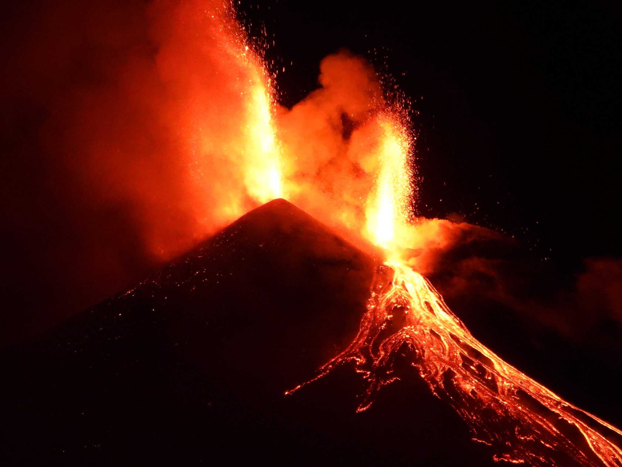
In detail, in the afternoon of April 29, a rapid increase in the amplitude of volcanic tremor was observed; the onset of eruptive activity at the Southeast Crater (SEC) was recorded by surveillance cameras at 21:57 UTC. Thick cloud cover limited observations during the first hour of activity, but from about 00:00 on April 30, visibility conditions improved considerably. At that time, lava overflow from the southeast rim of the Southeast Crater was already underway, feeding several lava branches to the southeast, and several vents at the summit of the Southeast Crater were producing explosive activity of varying intensity, with jets reaching 300-400 m high. Around 00:45, activity in the main vent, in the western part of the eruptive theater, became sustained, passing from Strombolian explosions to pulsed lava fountains, producing a well-fed lava overflow on the southern flank of the Southeast crater, which, having reached the base of the cone, extended towards Monte Frumento Supino. The activity began to lose intensity from 01:30, returning to Strombolian explosions, which continued until dawn. At 04:15, the Strombolian activity ceased and was followed by ash emission, which generated a plume about 1.5 km high above the summit of Etna and directed towards the southwest. After 06:15, the ash emission became discontinuous, stopping completely at 07:10. After this eruptive episode, the summit morphology of the South-East crater had changed due to the accumulation of material in the area of the former « mouth of the saddle » and the progressive filling of the deep fissure produced during the paroxysm of February 10, 2022 on the southern flank of the cone.
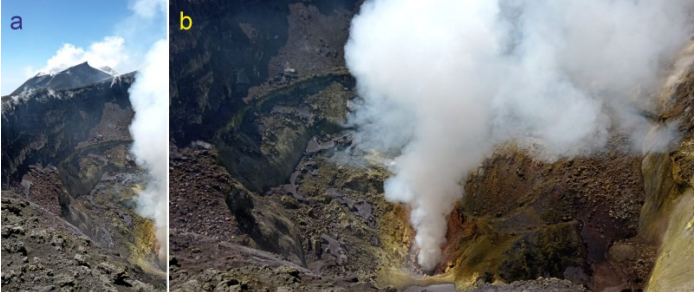
Northeast Crater, May 3, 2025. (a) The eastern portion of the crater, with the Southeast Crater in the background. (b) Degassing vent in the background of the crater. The view is from the northern rim of the crater.
According to Skysat satellite images from May 2, lava flows reached maximum lengths of 1.6 km on the southeast and south sides, covering areas of 0.17 km² (southeast) and 0.24 km² (south), with volumes of 0.24 and 0.17 x 10³ m³, respectively. These are therefore the largest flows produced so far during the current sequence of eruptive episodes, which began on March 15.
During the week, pulsed degassing was also observed from an open vent at the floor of the Northeast Crater (NEC), which was accompanied by faint rumbling sounds at depth.
Source : INGV
Photo : INGV , Boris Behncke , INGV
Italy , Stromboli :
WEEKLY BULLETIN, from April 28, 2025 to May 4, 2025 (publication date May 6, 2025)
SUMMARY OF ACTIVITY STATUS
Based on monitoring data, the following is highlighted:
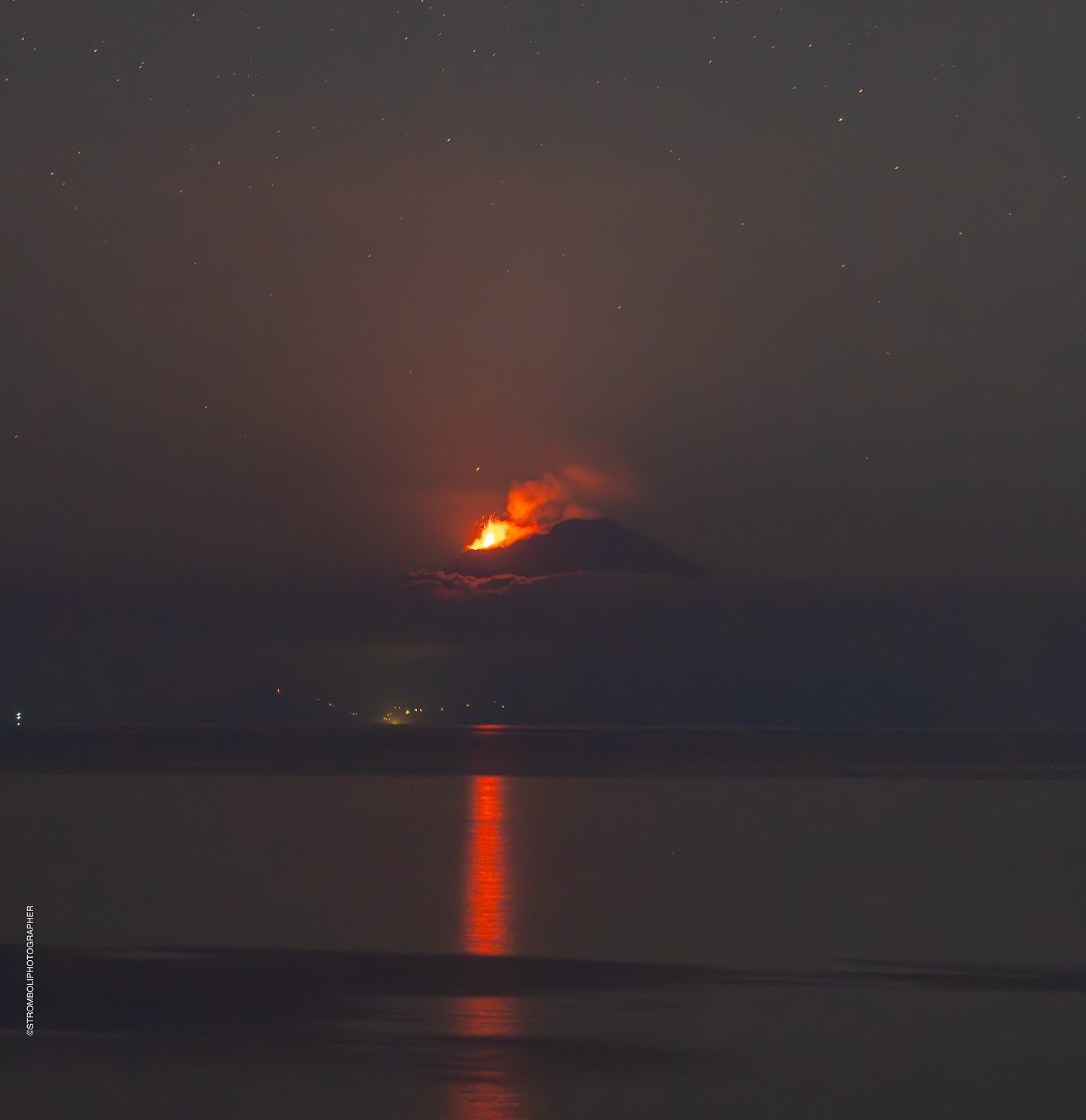
1) VOLCANOLOGICAL OBSERVATIONS: During this period, ordinary Strombolian eruptive activity was observed. The total hourly frequency ranged between average values (10-15 events/h). The intensity of the explosions was low to medium in the North (N) and South-Central (SC) crater areas.
2) SEISMOLOGY: The monitored seismic parameters show no significant variations.
3) GROUND DEFORMATION: Ground deformation monitoring networks showed no significant variations.
4) GEOCHEMISTRY: SO2 flux: average level. Soil CO2 fluxes in the Pizzo area (STR02): no updates.
C/S ratio in the plume: remains at high values.
Helium isotope ratio (R/Ra): no updates.
Soil CO2 fluxes in the San Bartolo area: average values.
Soil CO2 fluxes in the Scari area: average values.
5) SATELLITE OBSERVATIONS: Thermal activity observed by satellite in the summit area was generally low, with some moderate thermal anomalies.
VOLCANOLOGICAL OBSERVATIONS
During the observation period, Stromboli’s eruptive activity was characterized by analyzing images recorded by INGV-OE surveillance cameras located at an altitude of 190 m (SCT-SCV) and at Punta dei Corvi (SPCT). Explosive activity was produced mainly by four eruptive vents located in the northern area of the crater and by at least two vents located in the central-southern area.
Observations of explosive activity captured by surveillance cameras
In the northern (N) crater area, four active vents were observed, producing low-intensity explosive activity (less than 80 m in height) and sometimes medium-intensity explosive activity (less than 150 m in height). The ejected products consisted mainly of coarse materials (bombs and lapilli). The average explosion frequency ranged from 7 to 10 events/h.
In the South-Central (SC) area, explosive activity was produced by at least two vents; the explosions were primarily of low and medium intensity. The ejected products consisted primarily of fine materials (ash), sometimes mixed with coarse materials (lapilli and bombs). The average explosion frequency ranged from 1 to 7 events/h.
Source : INGV
Photo : Stromboli stati d’animo / Sebastiano Cannavo
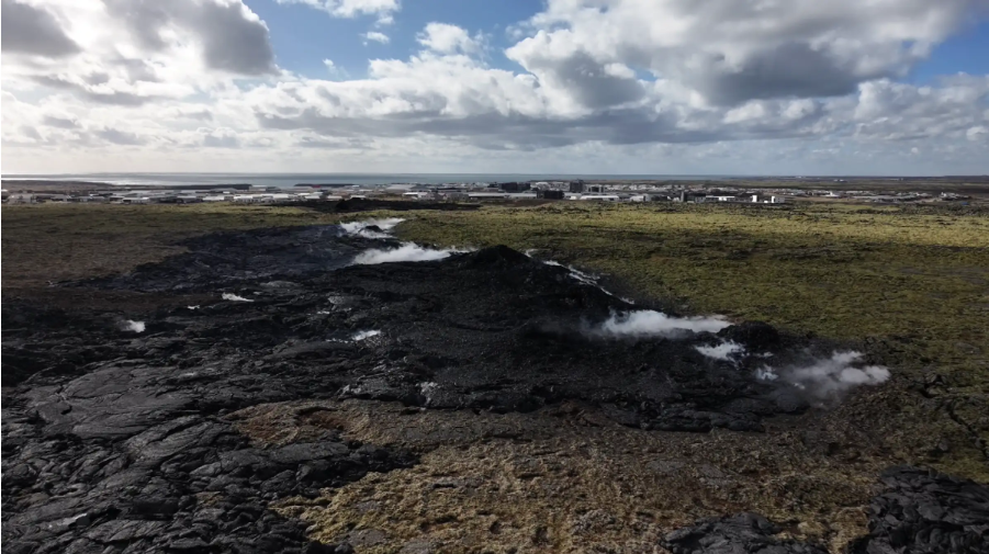
Iceland , Reykjanes Peninsula :
Continued Uplift in Svartsengi 6.5.2025
Update 6. May
Uplift in Svartsengi continues, although the rate has slowly decreased
Based on the rate of magma accumulation in recent weeks, the likelihood of a new eruption increases as autumn approaches
Seismic activity along the dike has decreased
The hazard assessment map has been updated and remains valid until May 20, unless conditions change
Deformation data (GPS) show clear signs of ongoing uplift in Svartsengi, although its rate has slowed in recent weeks. Scientists have assessed when the likelihood of a new magma intrusion or eruption might increase. This assessment assumes that the same amount of magma must accumulate beneath Svartsengi as in previous events in the Sundhnúkur crater row. If the uplift continues at the same rate as today, the likelihood of a new dike or eruption is expected to increase as autumn approaches. However, if the rate of uplift, and thus the magma accumulation under Svartsengi, changes, it will affect this assessment.
Scientists at the Icelandic Meteorological Office are now revising the potential scenarios and are evaluating, among other things, the amount of magma beneath Svartsengi necessary to trigger a new dike or even an eruption.
Changes in uplift rate assessed over weeks rather than days
Deformation data showing uplift often fluctuate slightly from day to day, even if the underlying magma inflow is steady. These daily variations can be caused by weather, measurement errors, or other natural factors that have little impact on the overall picture. Looking only at short time periods may give a misleading impression of whether uplift is increasing or decreasing. Therefore, it is important to analyze trends over a week or longer to get a realistic view of what is happening. It is crucial to interpret these data in the context of longer-term trends rather than focusing on measurements from individual daily GPS measurements.
Seismic activity continues along the dike that was formed on April 1, but activity has decreased since the end of the eruption. On average, several dozen earthquakes have been recorded per day over the past two weeks.
The hazard assessment map has been updated and remains valid until May 20, unless changes occur. A new information update is also planned for May 20.
Source : IMO
Photo : RÚV / Víðir Hólm Ólafsson Capture d’écran 5 Avril 2025 .
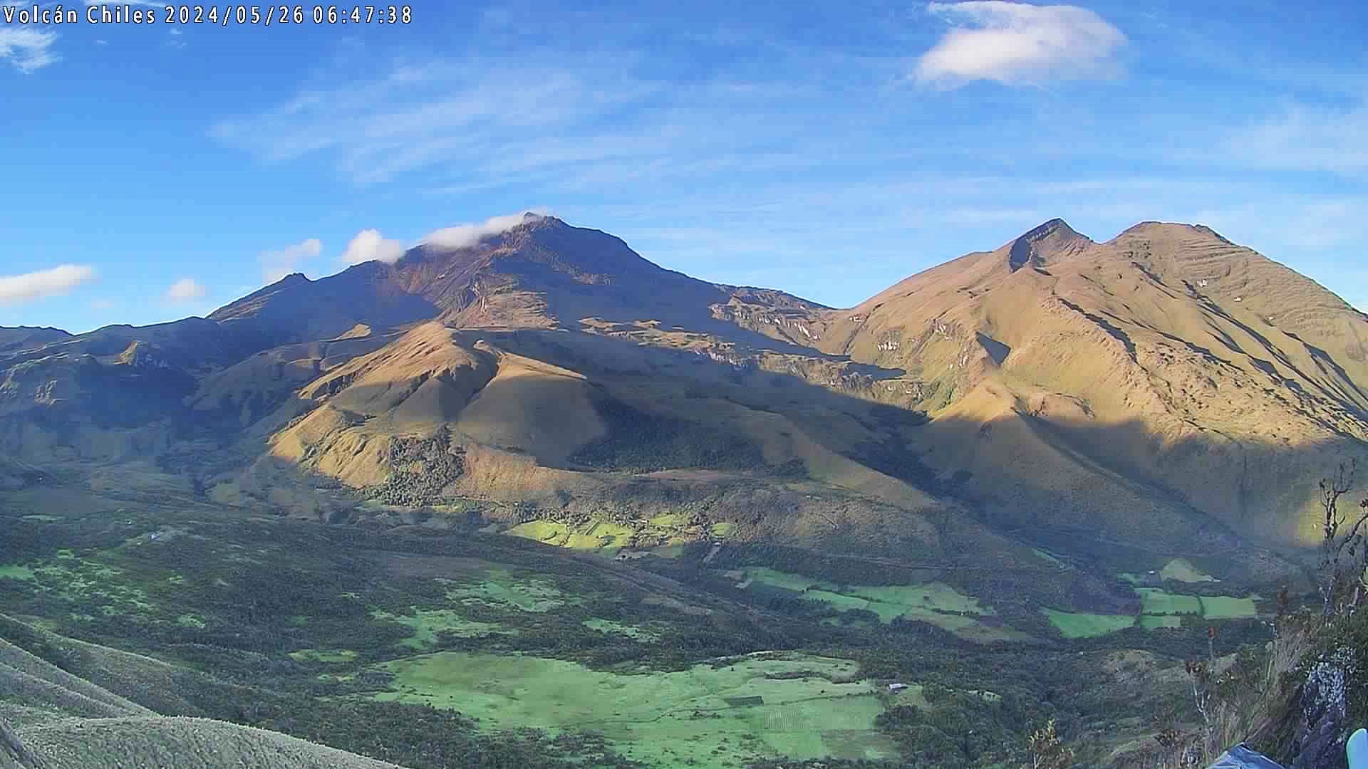
Colombia , Chiles / Cerro Negro :
Monitoring the activity of the Chiles and Cerro Negro volcanoes, the Colombian Geological Survey (SGC), an entity affiliated with the Ministry of Mines and Energy, reports that:
Between April 29 and May 6, 2025, the main variations in the monitored parameters compared to the previous week were:
● For this period, both the occurrence and the released seismic energy showed significant increases compared to the values reported in recent months. The predominance of seismicity associated with rock fracture continues in some sectors of the volcanic edifices.
● Most of the earthquakes were located in the collapse zone of the Chiles volcano, at distances less than 2.5 km from its summit (4,700 m above sea level), with depths between 2 and 6 km and a maximum magnitude of 1.7. A few other events were located southeast of Chiles Volcano, with depths up to 12 km and a maximum magnitude of 1.6.
● It should be noted that, since May 4th and up to the time of publication of this statement, there has been a significant increase in the number and energy of seismic activity related to fluid movement beneath the Chiles volcanic edifice.
● Today, May 6th, at 7:33 a.m., a fracture earthquake was recorded located in the collapse zone of the Chiles volcano, at a depth of 2.5 km and with a magnitude of 2.6, with no reports of a felt earthquake.
● Analysis of data from satellite sensors and ground stations continues to reveal changes related to deformation processes in the volcanic area.
Based on the assessment and correlation of monitored parameters, the SGC recommends closely monitoring developments through weekly bulletins and other information published through our official channels, as well as instructions from local and departmental authorities and the National Disaster Risk Management Unit (UNGRD).
Volcanic activity remains on Yellow alert: Active volcano with changes in the baseline behavior of monitored parameters and other manifestations.
Source et photo : SGC