April 21 , 2025 .
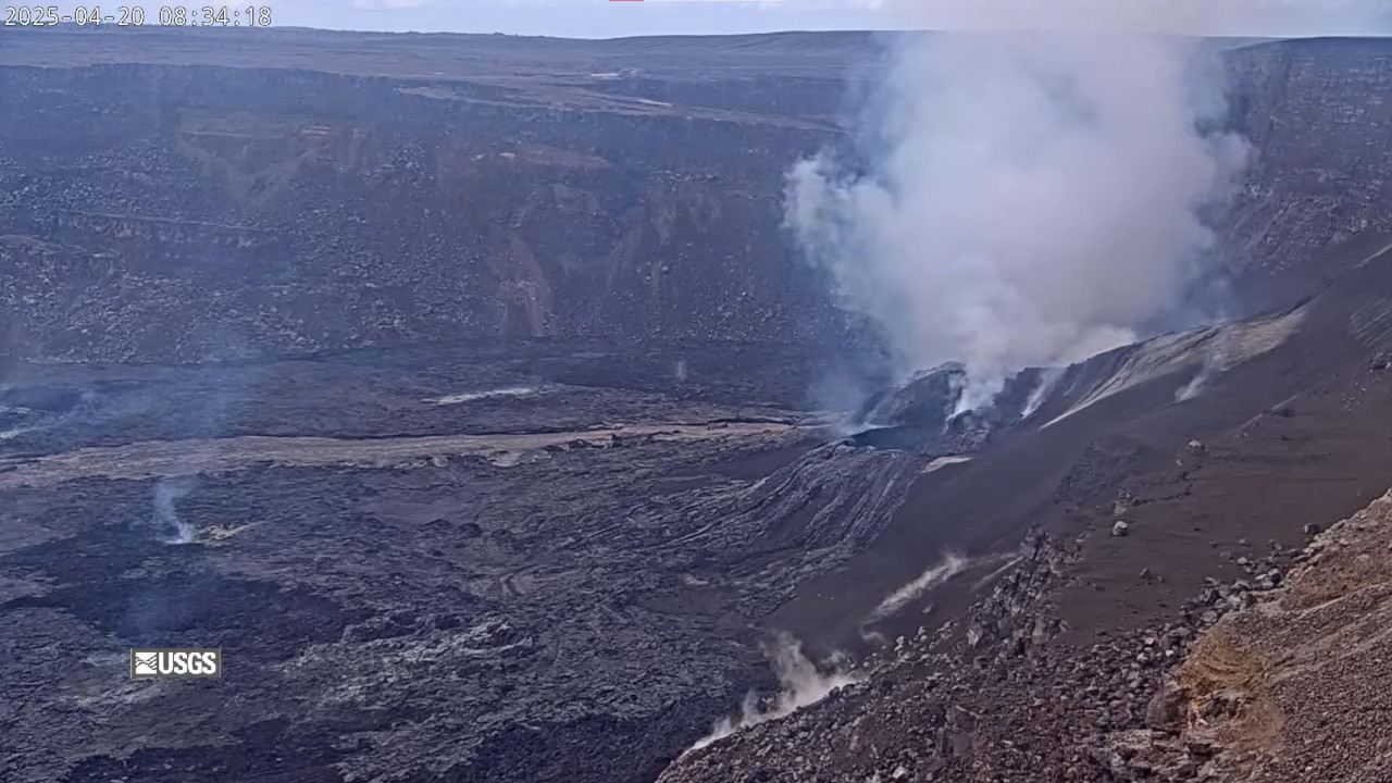
Hawaii , Kilauea :
Sunday, April 20, 2025, 9:15 AM HST (Sunday, April 20, 2025, 19:15 UTC)
19°25’16 » N 155°17’13 » W,
Summit Elevation 4091 ft (1247 m)
Current Volcano Alert Level: WATCH
Current Aviation Color Code: ORANGE
Activity Summary:
The ongoing Halemaʻumaʻu eruption has resumed with episode 18 at approximately 7:45 a.m. HST with lava flows from the south vent being fed by a 6-10 foot (2-3 meter) high fountain. This lava flow has made it approximately a third of the way across the crater floor (about 0.5 mile or about 1 kilometer). Tilt has leveled off, but is not yet deflating as typically coincides with the onset of high fountaining events from previous episodes.
Kīlauea’s current eruption in Halemaʻumaʻu crater within Kaluapele (the summit caldera) began on December 23, 2024. There have now been 18 episodes separated by pauses in activity. All eruptive activity remains within Hawaiʻi Volcanoes National Park. No significant activity has been noted along Kīlauea’s East Rift Zone or Southwest Rift Zone. Current hazards include volcanic gas emissions and windblown volcanic glass (Pele’s hair) and tephra that have impacted Hawaiʻi Volcanoes National Park and nearby communities.
Summit Observations:
Glow was observed from the south and north vents most of last night, but no spattering was observed. At approximately 7:45 a.m. HST, episode 18 resumed with a narrow lava flow from the south vent. The south vent has a lava fountain that is 6-10 foot (2-3 meter) high and is feeding a lava flow that has reached approximately a third of the way across the crater floor (about 0.5 mile or about 1 kilometer). Strong degassing is currently occurring from both vents.
This episode was preceded by low level activity began around 9:10 p.m. HST on April 16, with bursts of spatter every 10-20 seconds from the north vent, reaching up to a few meters (several feet) high. Spatter bursts continued to increase in size and frequency until about 9:30 p.m. HST when 10-15 foot high (3-5 meters high) dome fountains began. Lava overflowed from the north vent around 10:01 p.m. HST and fed a small lava flow that reached about 100 meters (a few hundred feet) from the vent. This activity ended abruptly at 11:21 p.m. HST.
The UWD and SDH tiltmeters had shown an inflationary signal that had been persistent since the end of episode 17. As of this morning, UWD has measured approximately 16.5 microradians of inflationary tilt since 9:45 a.m. HST April 9; equaling the inflation at the start of episode 16. Tilt has since leveled off with the start of the south vent fountaining and lava flow. High fountains as observed from previous episodes are expected when a strong deflationary signal is detected.
Volcanic gas emissions remain elevated and at heightened levels due to lava fountaining. The last sulfur dioxide (SO2) emission rate measured on April 10 was approximately 1,200 tonnes per day. Typical levels of Sulfur dioxide (SO2) emission have been about 1,000 tonnes per day during previous pauses. Sulfur dioxide (SO2) emission rates during earlier fountaining episodes have reached 50,000 tonnes per day. This morning, the plume is being carried towards the south to southwest.
Source et photo : HVO
Kamchatka , Bezymianny :
VOLCANO OBSERVATORY NOTICE FOR AVIATION (VONA)
Issued: April 21 ,2025
Volcano: Bezymianny (CAVW #300250)
Current aviation colour code: ORANGE
Previous aviation colour code: orange
Source: KVERT
Notice Number: 2025-20
Volcano Location: N 55 deg 58 min E 160 deg 35 min
Area: Kamchatka, Russia
Summit Elevation: 2882 m (9452.96 ft)
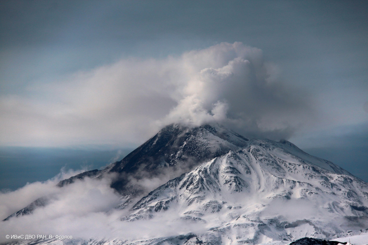
Volcanic Activity Summary:
An effusive eruption of the volcano continues, this is accompanied by powerful gas-steam emissions and hot avalanches. Satellite data by KVERT show a bright thermal anomaly over the volcano. Ash plume from hot avalanches extended about 45 km to the west-south-west of the volcano.
An effusive eruption of the volcano continues. Ash explosions up to 10-15 km (32,800-49,200 ft) a.s.l. could occur at any time. Ongoing activity could affect international and low-flying aircraft.
Volcanic cloud height:
2500-3000 m (8200-9840 ft) AMSL Time and method of ash plume/cloud height determination: 20250421/0354Z – MODIS AQUA 31m32
Other volcanic cloud information:
Distance of ash plume/cloud of the volcano: 45 km (28 mi)
Direction of drift of ash plume/cloud of the volcano: WSW / azimuth 256 deg
Time and method of ash plume/cloud determination: 20250421/0354Z – MODIS AQUA 31m32
Source : Kvert
Photo : V. Frolov. IVS FEB RAS
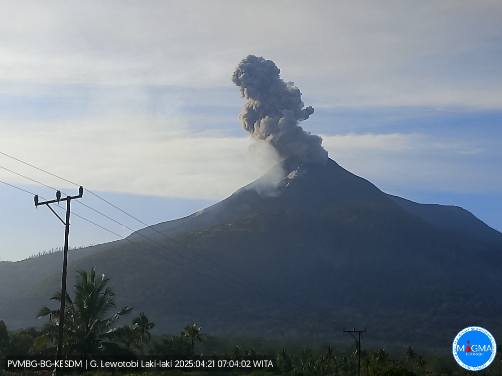
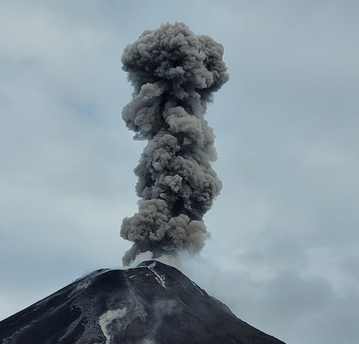
Indonesia , Lewotobi Laki-laki :
An eruption of Mount Lewotobi Laki-laki occurred on Monday, April 21, 2025, at 07:02 WITA with an observed ash column height of ± 800 m above the peak (± 2384 m above sea level). The ash column was observed to be gray in color with a thick intensity, oriented toward the north and northeast. This eruption was recorded on a seismograph with a maximum amplitude of 14.8 mm and a duration of 88 seconds.
VOLCANO OBSERVATORY NOTICE FOR AVIATION – VONA
Issued : April 21 , 2025
Volcano : Lewotobi Laki-laki (264180)
Current Aviation Colour Code : ORANGE
Previous Aviation Colour Code : orange
Source : Lewotobi Laki-laki Volcano Observatory
Notice Number : 2025LWK276
Volcano Location : S 08 deg 32 min 20 sec E 122 deg 46 min 06 sec
Area : East Nusa Tenggara, Indonesia
Summit Elevation : 5069 FT (1584 M)
Volcanic Activity Summary :
Eruption with volcanic ash cloud at 23h02 UTC (07h02 local).
Volcanic Cloud Height :
Best estimate of ash-cloud top is around 7629 FT (2384 M) above sea level or 2560 FT (800 M) above summit. May be higher than what can be observed clearly. Source of height data: ground observer.
Other Volcanic Cloud Information :
Ash cloud moving from north to northeast. Volcanic ash is observed to be gray. The intensity of volcanic ash is observed to be thick.
Remarks :
Eruption recorded on seismogram with maximum amplitude 14.8 mm and maximum duration 88 second.
Source et photo : Magma Indonésie .
Ecuador , El Reventador .
DAILY STATUS REPORT OF REVENTADOR VOLCANO, Sunday, April 20, 2025.
Information Geophysical Institute – EPN.
Surface Activity Level: High, Surface Trend: Ascending
Internal Activity Level: Moderate, Internal Trend: No change
From April 19, 2025, 11:00 a.m. to April 20, 2025, 11:00 a.m.:
Seismicity:
Below is the count of seismic events recorded at the reference station.
Explosion (EXP) 99
Long Period (LP) 8
Emission Tremor (TREMI) 9
Harmonic Tremor (TRARM) 4
Rainfall/Lahars:
No rainfall has been recorded in the volcano area. **Heavy rainfall could remobilize accumulated material, generating mud and debris flows that would cascade down the volcano’s flanks and flow into adjacent rivers.**
Emission/Ash Column:
Since yesterday afternoon, the surveillance camera network has recorded several gas and ash emissions, reaching heights of between 300 and 1,000 meters above the crater in both northwest and southwest directions. Associated with this activity, the Washington-based VAAC agency has released two reports of ash emissions reaching heights of 700 meters above the crater level in a westerly direction.
Other monitoring parameters:
The FIRMS satellite system recorded two thermal anomalies, the MIROVA-MODIS system recorded one thermal anomaly, and the MIROVA-VIIRS satellite system recorded one thermal anomaly over the past 24 hours.
Observation:
Yesterday evening and early this morning, incandescent material was repeatedly recorded descending the volcano’s flanks up to 1,000 meters below the crater level.
At the time of this report, the volcano remains cloudy.
Alert Level – SGR: Orange
Source : IGEPN
Photo : IGEPN via volcanes ecuador / FB.
Guatemala , Fuego :
Weather conditions: Clear.
Wind: West.
Precipitation: 0.0 mm.
Activity:
The Fuego Volcano Observatory reports volcanic activity consisting mainly of very weak exhalations, maintaining a small white column of degassing (water vapor and other magmatic gases) at an altitude of approximately 100 meters above the crater, which is moving northeast.

No rumbling or other sounds associated with this volcanic activity were recorded. Remaining blocks from the March 9 eruption were observed descending under gravity in the form of weak avalanches. These deposited materials can be evacuated in the form of lahars or mudflows due to precipitation, so it is recommended not to stay in or near the volcano’s ravines. Therefore, follow the recommendations in special bulletin BEFGO-013-2025.
Source : Insivumeh
Photo : Conred.