April 18 , 2025.
Hawaii , Kilauea :
HAWAIIAN VOLCANO OBSERVATORY DAILY UPDATE , U.S. Geological Survey
Thursday, April 17, 2025, 9:17 AM HST (Thursday, April 17, 2025, 19:17 UTC)
19°25’16 » N 155°17’13 » W,
Summit Elevation 4091 ft (1247 m)
Current Volcano Alert Level: WATCH
Current Aviation Color Code: ORANGE
Activity Summary:
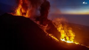
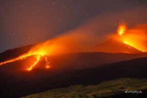
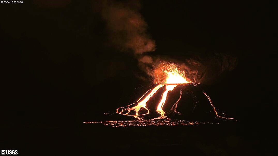
Episode 18 precursory activity began on the evening of April 16, 2025, with spattering bursts every 10–20 seconds from the north vent starting at 9:10 p.m. HST and strong glow from the south vent. Lava began overflowing from the north vent around 10:01 p.m. HST on April 16 marking the start of episode 18; lava flows made it about a hundred meters (several hundred feet) from the north vent before this activity ended at approximately 11:21 p.m. HST. The main lava fountaining phase of episode 18 is most likely to start sometime between today and this weekend, with the possibility of more lava flows preceding the fountaining phase.
Kīlauea’s current eruption in Halemaʻumaʻu crater within Kaluapele (the summit caldera) began on December 23, 2024. There have now been 18 episodes separated by pauses in activity. All eruptive activity remains within Hawaiʻi Volcanoes National Park. No significant activity has been noted along Kīlauea’s East Rift Zone or Southwest Rift Zone.
Summit Observations:
The south and north vents had significant glow for most of last night, along with north vent minor spattering and vent overflows. Strong degassing is currently occurring from both vents.
Low level activity began around 9:10 p.m. HST on April 16, with bursts of spatter every 10-20 seconds from the north vent, reaching up to a few meters (several feet) high. Spatter bursts continued to increase in size and frequency until about 9:30 p.m. HST when 10-15 foot high (3-5 meters high) dome fountains began. Lava overflowed from the north vent around 10:01 p.m. HST and fed a small lava flow that reached about 100 meters (a few hundred feet) from the vent. This activity ended abruptly at 11:21 p.m. HST. Glow from south vent disappeared when north vent had overflows but returned once north vent flows ceased. This is considered precursory activity to the main fountaining phase of episode 18 and there could be more lava flows preceding the fountaining phase.
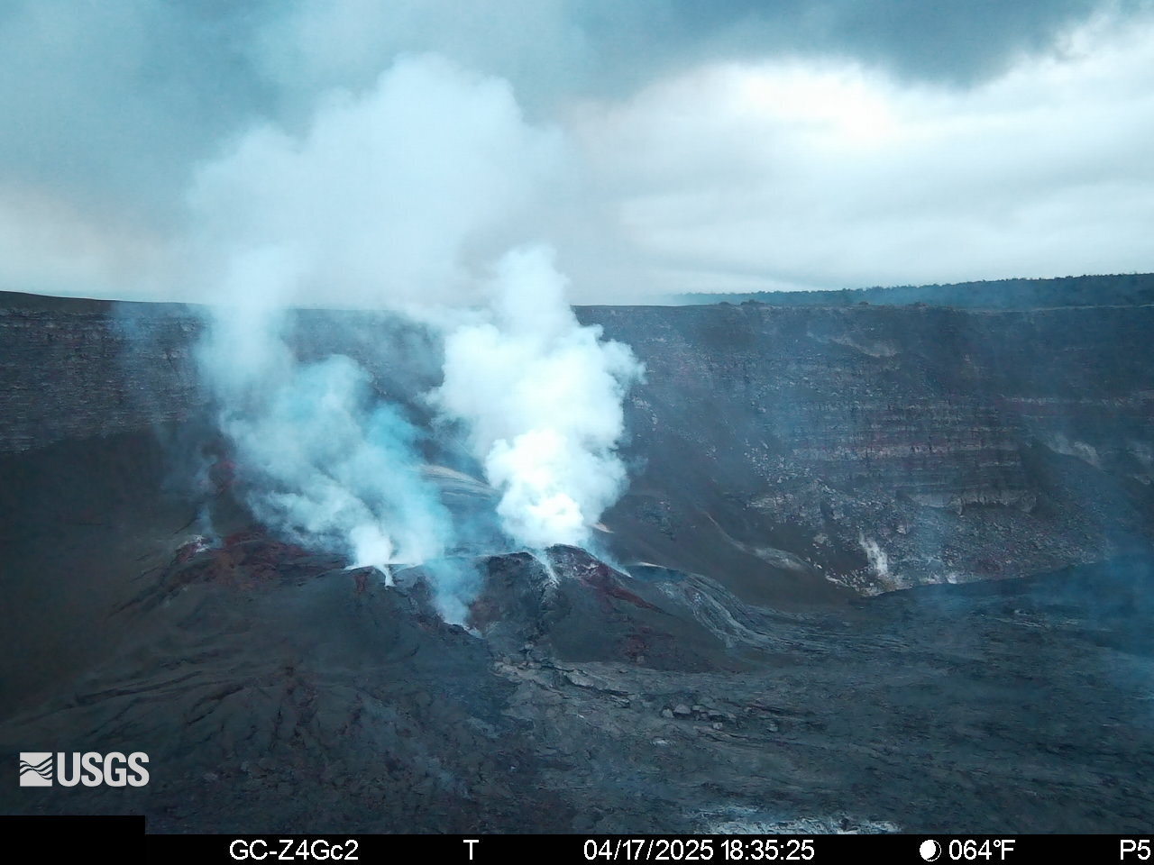
The UWD and SDH tiltmeters continue to show an inflationary signal that has been persistent since the end of episode 17. The main fountaining phase of episode 18 is not expected to begin until deflation starts at the UWD and SDH tiltmeters. As of this morning, UWD has measured more than 11 microradians of inflationary tilt since 9:45 a.m. HST April 9. Seismic tremor rapidly increased in intensity on April 16 with the north vent spattering and lava overflows but has since dropped to pre-overflow levels. Cyclic tremor patterns with 30-60 minute periods began at this time and continue to the present. These tremor patterns are reminiscent of cyclic patterns due to gas pistoning seen prior to episodes 14 and 15 but are longer period.
Volcanic gas emissions remain elevated and at heightened levels due to lava fountaining. The last sulfur dioxide (SO2) emission rate measured on April 10 was approximately 1,200 tonnes per day. Typical levels of Sulfur dioxide (SO2) emission have been about 1,000 tonnes per day during previous pauses. This morning, the plume is being carried towards the south to southwest.
Strands of volcanic glass known as Pele’s hair from previous episodes are still present throughout the summit area of Hawaiʻi Volcanoes National Park and surrounding communities and can be remobilized by wind.
Source et photos: HVO.
Alaska , Spurr :
ALASKA VOLCANO OBSERVATORY INFORMATION STATEMENT , U.S. Geological Survey
Thursday, April 17, 2025, 9:36 AM AKDT (Thursday, April 17, 2025, 17:36 UTC)
61°17’56 » N 152°15’14 » W,
Summit Elevation 11070 ft (3374 m)
Current Volcano Alert Level: ADVISORY
Current Aviation Color Code: YELLOW
Summary
Shallow earthquake activity underneath Mount Spurr remains elevated, though it has declined slightly over the past month. Ground deformation has also slowed over the past three weeks.
AVO has been unable to measure volcanic gases via airplane or helicopter since March 21 due to poor weather. Satellites have not detected SO2 from Mount Spurr since April 3, most likely due to cloudy weather.
Based on the recent modest changes in monitoring data and the inability to measure gas for the last month, the outcome of the current unrest is less certain. When weather conditions become more favorable, collection of new gas data will help us improve this assessment.
Overall, the likelihood of an eruption has decreased from March, but the volcano remains at an elevated level of unrest and an explosive eruption (or eruptions) like those that occurred in 1953 and 1992 is still possible.
We expect to see increases in seismic activity, gas emissions, and surface heating prior to an eruption, if one were to occur. Such stronger unrest may provide days to weeks of additional warning.
Recent observations
The last gas-measurement flight was on March 21; poor weather has prevented flights since that time. Analysis of the data from three flights in March suggests emission rates of about 1000 metric tons per day CO2 from Crater Peak. This value is high, but similar values were reported in 2004, when the volcano did not erupt. No SO2 was detected from Crater Peak. At the summit, measurements from the March flights show several hundred metric tons per day of CO2 and SO2. These values are also similar to what was measured in 2004–2006.
Satellite detections of SO2 occurred on 7 occasions in mid-March and early April and were broadly consistent with airborne measurements. No satellite SO2 detections have been made since April 3. This may be due to cloudy weather limiting satellite views, or alternatively, could reflect a decrease in degassing.
Over the last month, AVO has located about 60 to 80 earthquakes per week under Mount Spurr (time-series figure and map). The rate of shallow earthquakes (less than 2.5 miles, or 4 km, below sea level) is lower than in January and February. However, the rate of deep earthquakes (greater than 6 miles, or 10 km, below sea level) has been fairly constant, suggesting that magma remains active deep beneath the volcano.
Ground deformation, or inflation, as measured by GNSS (GPS) has slowed or paused since about March 19. A similar pause occurred in Fall 2024.
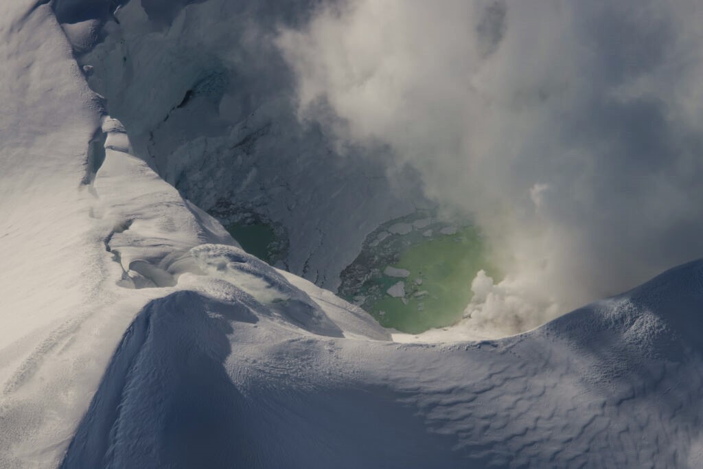
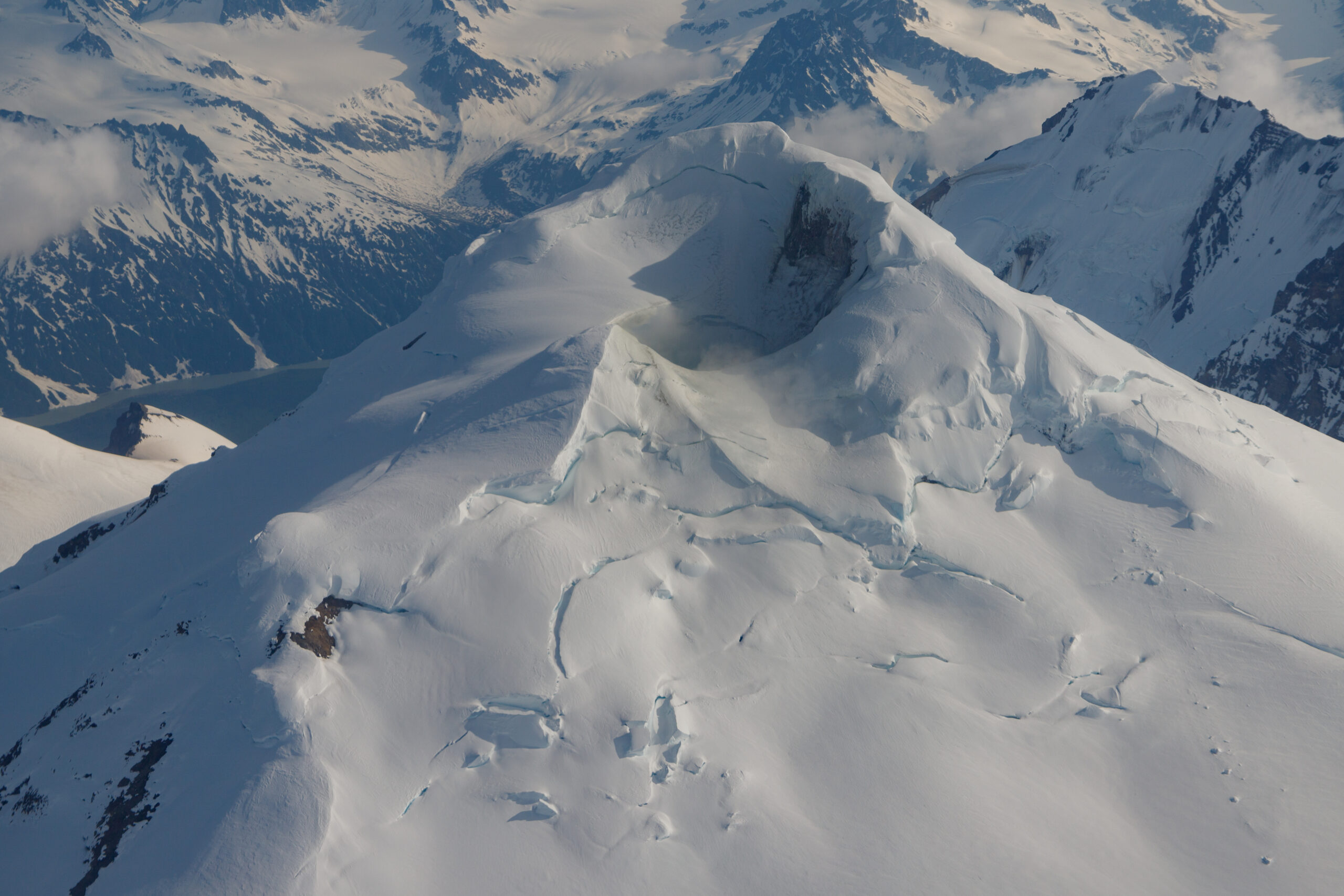
Collapse of snow and ice into the summit crater lake that formed during this period of unrest continues, along with steam emissions from fumaroles within and around the summit crater. There have been no significant changes to the fumaroles within Crater Peak over the past month.
Interpretations and Hazards
The modest changes in monitoring data over the past month suggest that the likelihood of an eruption has decreased, and the inability to measure gas has made it more difficult to assess the current state of the volcano. However, the current level of unrest remains above background, monitoring data show the presence of magma under the volcano, and an eruption is still possible. If an eruption were to occur, an explosive eruption (or eruptions) like those that occurred in 1953 and 1992 is the most likely outcome.
Fluctuating rates of seismic activity and other monitoring data have occurred during past unrest periods, for example before the eruption of Redoubt Volcano in 2009. Such fluctuations make the outcome of the unrest less certain, and it is possible that the unrest could continue to decline, ending in no eruption, or it could increase again (see illustration).
Should earthquake activity or other monitoring data suggest that an eruption is likely within hours or days, AVO would raise the Aviation Color Code and Alert Level for Mount Spurr.
Source : AVO
Photos : Mitchell, Mitch / AVO/USGS , Mota, Rui / Alaska Volcano Observatory / U.S. Geological Survey , june 2024
Indonesia , Lewotobi Laki-laki :
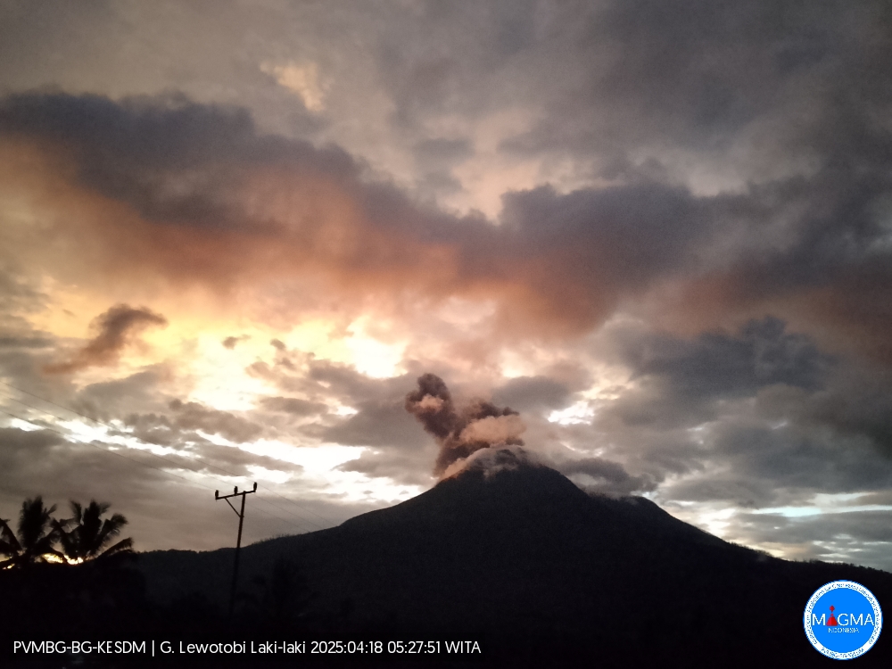
An eruption of Mount Lewotobi Laki-laki occurred on Friday, April 18, 2025, at 05:23 WITA with an observed ash column height of ± 700 m above the peak (± 2284 m above sea level). The ash column was observed to be gray in color with a thick intensity, oriented toward the north and northeast. This eruption was recorded on a seismograph with a maximum amplitude of 11.8 mm and a duration of 93 seconds.
VOLCANO OBSERVATORY NOTICE FOR AVIATION – VONA
Issued : April 18 , 2025
Volcano : Lewotobi Laki-laki (264180)
Current Aviation Colour Code : ORANGE
Previous Aviation Colour Code : orange
Source : Lewotobi Laki-laki Volcano Observatory
Notice Number : 2025LWK208
Volcano Location : S 08 deg 32 min 20 sec E 122 deg 46 min 06 sec
Area : East Nusa Tenggara, Indonesia
Summit Elevation : 5069 FT (1584 M)
Volcanic Activity Summary :
Eruption with volcanic ash cloud at 21h23 UTC (05h23 local).
Volcanic Cloud Height :
Best estimate of ash-cloud top is around 7309 FT (2284 M) above sea level or 2240 FT (700 M) above summit. May be higher than what can be observed clearly. Source of height data: ground observer.
Other Volcanic Cloud Information :
Ash cloud moving from north to northeast. Volcanic ash is observed to be gray. The intensity of volcanic ash is observed to be thick.
Remarks :
Eruption recorded on seismogram with maximum amplitude 11.8 mm and maximum duration 93 second.
Source et photo : Magma Indonésie .
Colombia , Galeras :
San Juan de Pasto, April 15, 2025, 4:20 p.m.
Monitoring the activity of the Galeras Volcano, the Colombian Geological Survey (SGC), an entity affiliated with the Ministry of Mines and Energy, reports that:
Between April 8 and 15, 2025, volcanic activity continued to show levels similar to those recorded in previous weeks. The main variations in the monitored parameters were:
● At low levels, a slight decrease in occurrence and a slight increase in the released seismic energy were observed. The predominance of seismicity associated with rock fracture processes within the volcanic system remained.
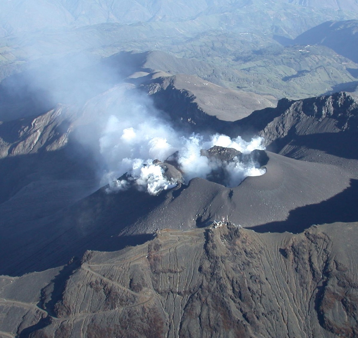
● The most recurrent seismic source continues to be concentrated near the main crater, at distances of less than 1 km and at depths up to 2 km from the Galeras summit (4,200 m above sea level). Other earthquakes have been located scattered throughout the volcanic area, at distances of up to 12 km, at depths between 3 and 8 km, and with a maximum magnitude of 1.7. No earthquakes have been reported as felt.
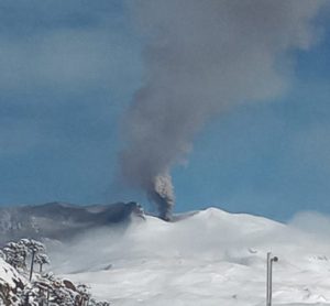
● Regarding the volcano’s surface activity, gas emissions have been observed from the El Paisita fumarole fields, to the north, and Las Chavas, to the west of the active cone, with low, white columns whose dispersion varies depending on the wind direction.
● Other volcanic monitoring parameters have shown stability.
Based on the above, the SGC recommends closely monitoring developments through weekly bulletins and other information published through our official channels, as well as instructions from local and departmental authorities and the National Disaster Risk Management Unit (UNGRD).
Volcanic activity remains on alert. Yellow: active volcano with changes in the baseline level of monitored parameters and other manifestations.
Source et photo : SGC
Peru , Sabancaya :
Analysis period: From April 7, 2025 to April 13, 2025, Arequipa, April 14, 2025
Alert Level: ORANGE
The Peruvian Geophysical Institute (IGP) reports that eruptive activity at the Sabancaya Volcano continues. During this period, an average of 0 daily explosions were recorded, with columns of ash and gas up to 800 m above the volcano’s summit. Therefore, the volcanic alert level remains at ORANGE.
The IGP recorded and analyzed the occurrence of 23 volcanic earthquakes, associated with the circulation of magmatic fluids within the Sabancaya Volcano, as well as earthquakes related to rock fracturing. No explosions were recorded during this period.

Columns of ash and gas were observed up to 800 m above the volcano’s summit. The predominant direction of these emissions was toward the east and southeast of the volcano over a distance of less than 10 km.
No significant deformation of the volcanic edifice was recorded.
No thermal anomalies were identified.
Moderate emissions (237 tons/day) of sulfur dioxide (SO2) were observed.
RECOMMENDATIONS
• Maintain the orange volcanic alert level.
• Do not approach within a radius of 12 km of the crater.
Source : Cenvul
Photo : Benjamin Bernard