March 21 , 2025 .
Hawaii , Kilauea :
HAWAIIAN VOLCANO OBSERVATORY DAILY UPDATE , U.S. Geological Survey
Thursday, March 20, 2025, 8:06 AM HST (Thursday, March 20, 2025, 18:06 UTC)
19°25’16 » N 155°17’13 » W,
Summit Elevation 4091 ft (1247 m)
Current Volcano Alert Level: WATCH
Current Aviation Color Code: ORANGE
Activity Summary:
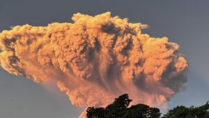
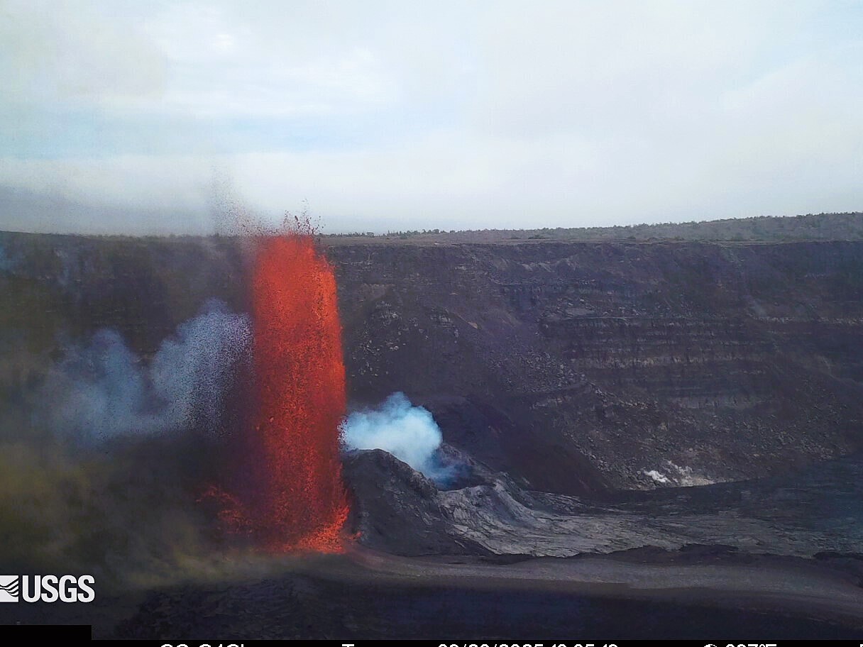
Episode 14 of the ongoing Halemaʻumaʻu eruption began at 9:26 a.m. HST on March 19 with continuous lava effusion from the north vent. Both vents are currently active with large fountains reaching 400-600 ft (100-200 m). The south vent began sustained fountaining around 6:30 a.m. HST on March 20 followed by sustained fountains in the north cone at 6:50 a.m. HST. The north cone shut off at 7:46 a.m. HST, and the south cone fountains have reached heights up to 500-700 feet (150-215 m).
Episode 14 was preceded by seven small, short-lived lava flows that began at approximately midnight on March 19 and continued until 6:02-6:10 a.m. The onset of the continuous eruption with cyclic low lava fountaining (30 ft high) and drainback events of the lava pond extended from 9:26 a.m. HST March 19 through this morning with increased intensity at 2:00 a.m. HST March 20. Sustained fountaining from both cones began around 6:30 a.m. HST on March 20.
Each episode of Halemaʻumaʻu lava fountaining since December 23, 2024, has continued for 13 hours to 8 days and episodes have been separated by pauses in eruptive activity lasting less than 24 hours to 12 days.
Kīlauea’s current eruption in Halemaʻumaʻu crater within Kaluapele (the summit caldera) began on December 23, 2024. There have been 13 episodes of lava fountaining separated by pauses in activity. Episode 13 ended at 3:13 p.m. HST on March 11. All eruptive activity remains within Hawai’i Volcanoes National Park. No significant activity has been noted along Kīlauea’s East Rift Zone or Southwest Rift Zone.

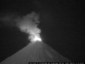
Once the northern eruptive vent within Halemaʻumaʻu crater at the summit of Kīlauea became active on March 19, it began exhibiting cyclic dome fountaining and lava drainback approximately every 5 minutes. In this image captured from above on the western crater rim, the drainback is evidenced by whirlpool textures in the lava pond’s crustal plates.
Summit Observations:
Small, degassed lava flows began erupting continuously from both vents within Halemaʻumaʻu crater beginning at 9:26 a.m. HST from the north vent and 9:50 a.m. HST from the south vent on March 19. The occasional spatter bursts in both cones slowly waned throughout the morning after 7:00 a.m. HST, but activity in both cones picked back up around 9:20 a.m. HST just prior to the start of continuous eruption. The south vent flows became sporadic around 10:35 a.m. HST. Cyclic low dome fountains alternated with short drainbacks in the north vent every 5-10 minutes with the interval decreasing over time. Maximum dome fountains were 30 feet high (10 meters) and occurred within a 200 foot by 150 foot (65 by 45 meters) lava pond that drops about 5-10 feet (2-3 meters) during each drainback event within the north cone. The size of the dome fountains increased significantly around 2:00 a.m. HST March 20th with fountain heights reaching 50-100 feet (15-30 m). At 6:30 a.m. the south vent started to fountain continuously and was joined by the north vent at 6:50 a.m. HST. By 7:15 a.m. HST fountains reached heights of 400-600 feet (120-180 meters) and lava was covering more than half of Halema’uma’u crater floor.
Prior to start of continuous eruptions, episode 14 was preceded by seven small, short-lived, sluggish lava flows that began overflowing the south vent just before midnight. The first flow was active from 23:58 p.m. HST March 18 to 00:02 a.m. HST March 19 and the second from 00:56 to 1:03 a.m. HST. These were followed by a third tongue of lava from the south vent from 1:57 to 2:01 a.m. HST and a fourth from 3:36 to 3:46 a.m. HST. The fifth and sixth sluggish lobes erupted from 4:20 a.m. to 4:28 a.m. HST and 5:04 to 5:14 a.m. HST. A seventh short-lived flow erupted from the south vent between 6:02 a.m. and 6:10 a.m. HST March 19. This flow was accompanied by large spatter bursts from the south vent that could be seen over the top of the north cone on the V1 camera. None of the seven flows lasted more than 10 minutes nor went more than about 50 feet (15 meters) from the south vent. Occasional spatter bursts could be seen in the north vent on the V1 camera throughout the night and becoming more frequent in the early morning hours.
The rate of summit inflationary tilt slowed over past 24 hour until the onset of high fountaining after 6:30 a.m. HST. Inflationary tilt recovered 12 microradians since the end of the last episode. Seismic tremor rapidly increased at 6:30 a.m. HST and tilt at UWD switched from inflation to deflation at about 6:52 a.m. HST, when sustained fountaining of the north vent joined with the south vent.
An SO2 emission rate of 1,200 t/d was measured on March 18, which is a typical rate for eruption pauses. Emissions of SO2 during the current high fountains will be in the 20,000 to 50,000 tonnes per day range based on past measurements. The fountains are also currently producing tephra such as pumice and Pele’s hair that can be transported long distances downwind from the vents.
Rift Zone Observations:
Rates of seismicity and ground deformation remain very low in the East Rift Zone and Southwest Rift Zone with no significant earthquake activity in the past 24 hours. Sulfur dioxide (SO2) emissions from the East Rift Zone remain below detection limit.
Source : HVO.
Photos : USGS / M. Zoeller. USGS .
Indonesia , Lewotobi Laki-laki :
LEWOTOBI LAKI-LAKI ACTIVITY LEVEL INCREASES FROM LEVEL III (SIAGA) TO LEVEL IV (AWAS).
Mount (L.) Lewotobi Laki-laki (Lewotobi Laki) is one of two twin volcanoes located in the southeastern part of Flores Island, in East Nusa Tenggara Province. This mountain has a height of 1,584 meters above sea level and is a still-active stratovolcano.
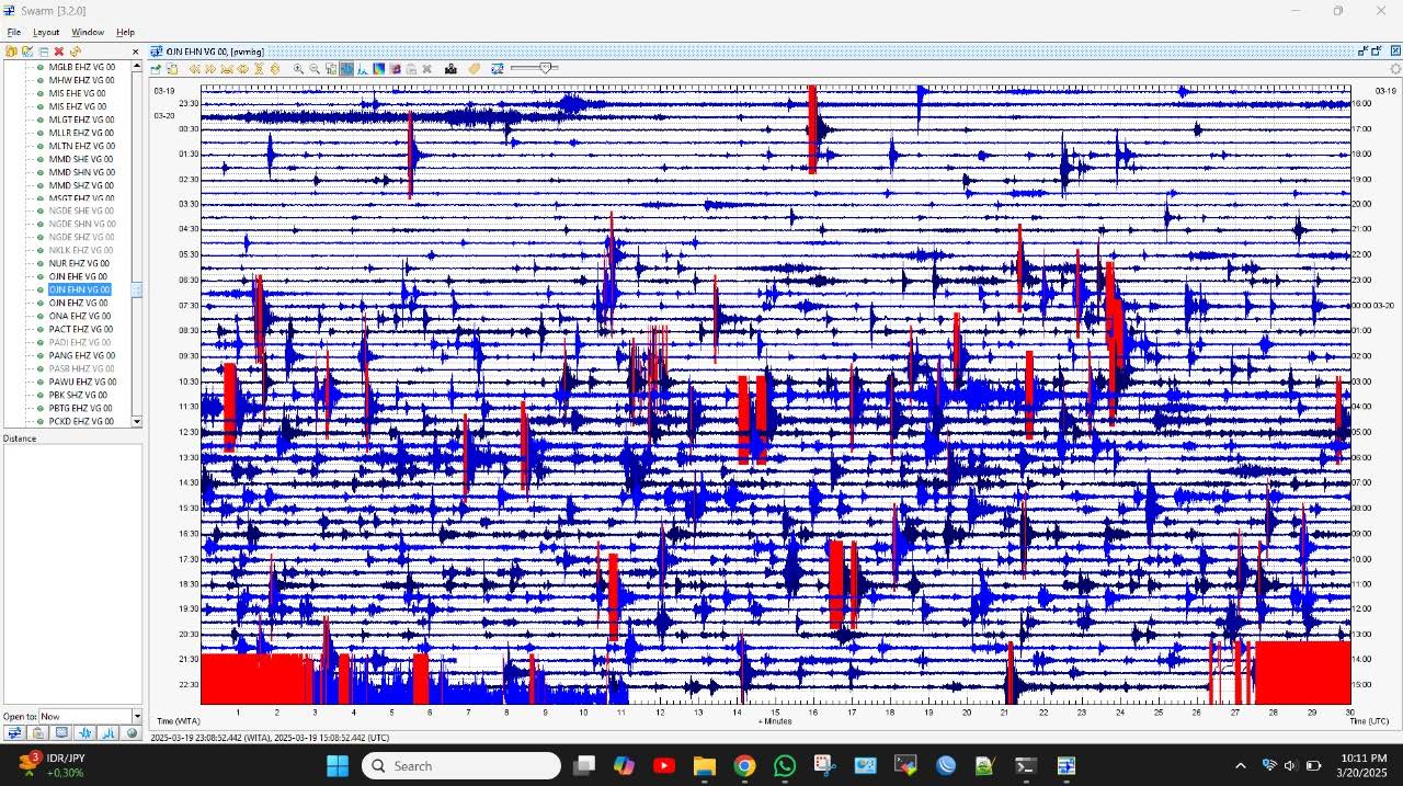
Visual and seismic observations of Mount Lewotobi Laki-laki from March 13 to 20, 2025, are as follows:
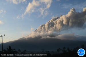
The volcano is clearly visible until it is covered by fog. The smoke observed from the main crater is white, gray, and black, with a thin, medium, to thick intensity, approximately 100 to 300 meters above the summit. The height of the eruption column is between 1,000 and 2,500 meters from the summit; the ash column from the eruption is gray.
The types of earthquakes recorded during the period from March 13 to 20, 2025, were:
55 eruption earthquakes,
176 emission earthquakes,
67 harmonic tremors,
1 Tornillo-type earthquake,
5 low-frequency earthquakes,
1 shallow volcanic earthquake,
83 deep volcanic earthquakes,
13 local tectonic earthquakes,
46 distant tectonic earthquakes,
3 flood vibrations (lahars),
1 continuous tremor with a dominant amplitude of 3.7 mm.
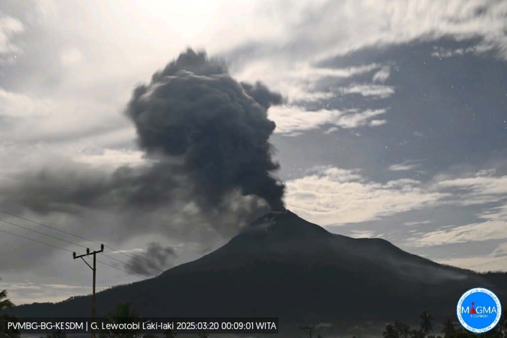
Visual observations from March 13 to 20, 2025, showed that volcanic activity at Mount Lewotobi Laki-laki increased significantly, with an average height of 1,000 to 2,500 meters for the eruptive column.
During this period, the seismicity of the emissions remained the same as in the previous period, with low to moderate pressure. Incandescence at the summit was last seen on March 13, 2025, and has not been seen again since this report was written. This indicates that the incandescent material has not yet been pushed to the surface.
The smoke emitted in the area around the peak on the northwest side, which forms like fissures, tends to be thin-thick, while the solfatara penetrations on the northeast and southwest sides appear thin. The presence of crater smoke (solfatara) is caused by the presence of an alteration zone (weak zone), so solfatara smoke can be seen emanating from this area. The area could potentially experience a « directed explosion » (a direct eruption in one direction), which could occur in a northwest/northeast and southwest direction from Mount Lewotobi Laki-laki.
Eruption earthquakes during this period have increased slightly compared to the previous period, indicating that there is still a supply of magma capable of erupting.
The number of harmonic earthquakes continues to fluctuate as in the previous period, indicating vibrations due to fluid movement (magma/gas/water vapor) beneath Mount Lewotobi Laki-laki. Fluid movement or gas release from magma filling fractures tends to be steady but always occurs at a shallow depth moving toward the surface.
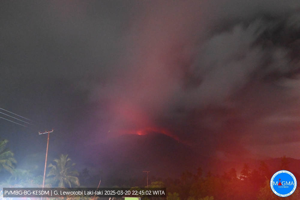
An eruption of Mount Lewotobi Laki-laki occurred on Thursday, March 20, 2025, at 10:56 PM WITA, with an observed ash column height of ± 8,000 m above the peak (± 9,584 m above sea level). The ash column was observed to be gray to black in color with a thick intensity, oriented southwest and west. This eruption was recorded on a seismograph with a maximum amplitude of 47.6 mm and a duration of 669 seconds.
A Tornillo-type earthquake was recorded on March 16, 2025, indicating the presence of fluid filling fractures in the fault zone around Mount Lewotobi Laki-laki, consistent with a slight increase in local tectonic earthquakes, which have increased compared to the previous period. The number of low-frequency earthquakes increased slightly compared to the previous period, indicating that magmatic fluid flow from the conduit to the surface is still occurring.
Shallow volcanic earthquakes began to be recorded on March 20, 2025, indicating that the intensity of magmatic activity in the magma chamber of Lewotobi Laki-laki volcano is increasing and moving toward shallower depths. The last shallow volcanic earthquake was recorded on February 12, 2025.
The number of deep volcanic earthquakes increased significantly on March 19 and 20, 2025, indicating that the intensity of magmatic activity in the magma chamber of Lewotobi Laki-laki volcano is increasing quite rapidly. This rapid increase is leading to an eruption that will likely be larger than that of the previous period. The number of local and remote tectonic earthquakes is still relatively fluctuating compared to the previous period. The recorded local tectonic earthquakes with hypocenters around Mount Ile Muda likely indicate that there is still input from the interior that is still far from the body of Mount Lewotobi Laki-laki. Both local tectonic earthquakes and remote tectonic earthquakes around Mount Lewotobi Laki-laki affect the activity of Mount Lewotobi Laki-laki, so it is necessary to be vigilant if there is a sudden increase in the number of these two types of tectonic earthquakes, especially local tectonic earthquakes that will affect the height of the eruption or the activity of Mount Lewotobi Laki-laki.
During this period, flood vibrations increased, paralleling the increasing intensity of rainfall around Mount Lewotobi Laki-laki. Materials released by the eruption and deposited around Mount Lewotobi Laki-laki have the potential to transform into lahars in the event of heavy rainfall.
On March 19, 2025, continuous microtremors with a dominant amplitude of 3.7 mm were recorded. This indicates magma migration toward the surface, which was then likely to affect the height of the eruption on March 15, 2025.
On March 20, 2025, earthquakes increased, until at 18:00 WITA, the number of volcanic earthquakes reached 117.
Based on the results of a comprehensive analysis and evaluation of visual and instrumental monitoring, it shows that visual and seismic activity at Mount Lewotobi Laki-laki has increased quite significantly, so that the activity level of Mount Lewotobi Laki-laki has been raised from level III (WASPADA) to level IV (AWAS) on March 20, 2025 at 22:30 WITA.
Source : PVMBG
Photos : Magma Indonésie , PVMBG.
Colombia , Galeras :
San Juan de Pasto, March 18, 2025, 2:30 p.m.
Monitoring the activity of the Galeras Volcano, the Colombian Geological Survey (SGC), an entity affiliated with the Ministry of Mines and Energy, reports that:
Between March 11 and 17, 2025, volcanic activity showed an increase in seismic activity. Compared to the previous week, the main variations in the monitored parameters were:
• An increase in seismic activity was recorded, with a decrease in the energy released.
The predominance of seismic activity associated with rock fracture processes within the volcanic system continued.
• There are still traces of very low-energy events in the main crater area, at distances less than 1 km and at depths less than 2 km. In general, the earthquakes were located scattered throughout the volcanic region, at distances of up to 15 km, with depths between 1 and 12 km from the summit of Galeras (4200 m above sea level) and with a maximum magnitude of 1.3.

• Gas emissions were observed coming from the floor of the main crater and from the fumarole fields of El Paisita to the north and Las Chavas to the west of the active cone, with low white columns and variable dispersion depending on the wind direction.
• Other volcanic monitoring parameters showed stability.
Based on the above, the SGC recommends closely monitoring developments through weekly bulletins and other information published through our official channels, as well as instructions from local and departmental authorities and the National Disaster Risk Management Unit (UNGRD).
Volcanic activity remains on alert. Yellow: active volcano with changes in the baseline behavior of monitored parameters and other manifestations.
Source et photo : SGC
Peru , Sabancaya :
Analysis period: March 10, 2025 to March 16, 2025, Arequipa, March 17, 2025
Alert Level: ORANGE
The Peruvian Geophysical Institute (IGP) reports that eruptive activity at the Sabancaya Volcano continues. During this period, an average of 0 daily explosions were recorded, with columns of ash and gas up to 1,200 m above the volcano’s summit. Therefore, the volcanic alert level remains at ORANGE.
The IGP recorded and analyzed the occurrence of 29 volcanic earthquakes, associated with the circulation of magmatic fluids within the Sabancaya Volcano, as well as earthquakes related to rock fracturing. No explosions were recorded during this period.
Columns of ash and gas were observed up to 1,200 m above the volcano’s summit. The predominant direction of these emissions was toward the west and southwest of the volcano over a distance of less than 10 km.
No significant deformation of the volcanic edifice was recorded.
No thermal anomalies were identified.
Moderate emissions (297 tons/day) of sulfur dioxide (SO2) were observed.
RECOMMENDATIONS
• Maintain the orange volcanic alert level.
• Do not approach within a radius of 12 km of the crater.
Source : Cenvul
Photo : Ingemmet
Guatemala , Santiaguito :
Weather Conditions: Clear.
Wind: Northeast.
Precipitation: 0.0 mm.
Activity:
The crater displays a white fumarole at an altitude of 3,000 meters, moving toward the west and southwest. Weak, moderate, and strong explosions were observed, accompanied by ash columns at an altitude of 3,700 meters, extending toward the west and southwest for approximately 20 kilometers. Ashfall was reported in the villages of Loma Linda and San Marcos Palajunoj, as well as in the farms of El Patrocinio, El Rosario, and others in the area.
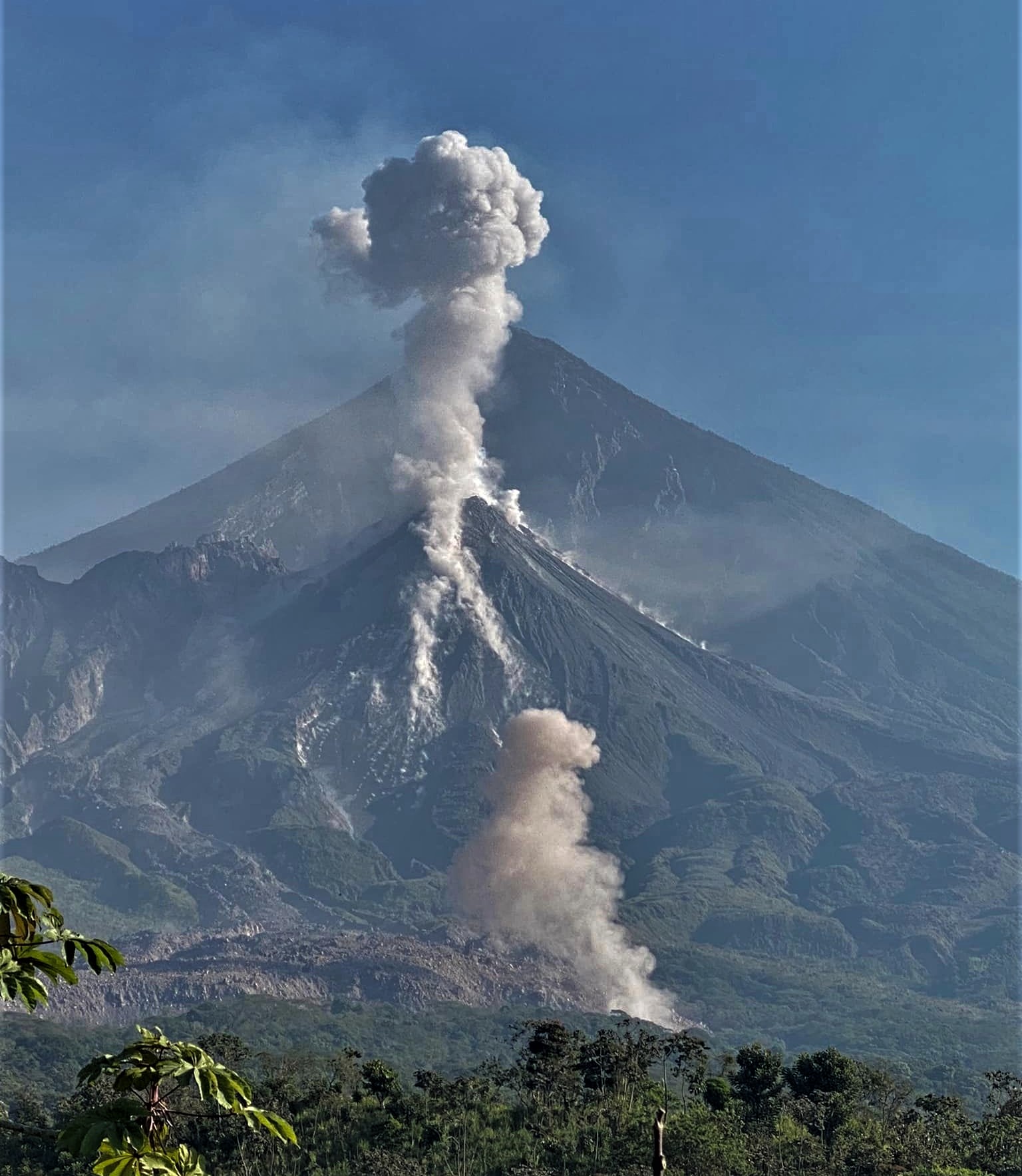
This activity generates avalanches, some accompanied by short-range pyroclastic flows. Avalanches are also observed on the lava promontories of the southwest flank. Due to the activity described, larger pyroclastic flows, similar to those of 2022, may be generated; therefore, it is recommended not to approach the dome areas or remain near or in the ravines close to the volcanic complex.
Please note that rain may occur in the afternoon and evening.
Source : Insivumeh.
Photo : Armando Pineda