March 13 , 2025.
Alaska , Spurr :
ALASKA VOLCANO OBSERVATORY INFORMATION STATEMENT , U.S. Geological Survey
Wednesday, March 12, 2025, 8:31 AM AKDT (Wednesday, March 12, 2025, 16:31 UTC)
61°17’56 » N 152°15’14 » W,
Summit Elevation 11070 ft (3374 m)
Current Volcano Alert Level: ADVISORY
Current Aviation Color Code: YELLOW
Summary
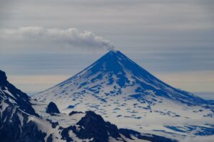
During overflights on March 7 and 11, AVO measured significantly elevated volcanic gas emissions from Mount Spurr volcano. Newly reactivated fumaroles (gas vents) were also seen at the volcano’s Crater Peak vent. Elevated earthquake activity and ground deformation continue.
The increase in gas emissions confirms that new magma has intruded into the Earth’s crust beneath the volcano and indicates that an eruption is likely, but not certain, to occur within the next few weeks or months.
The most likely outcome of the current unrest is an explosive eruption (or eruptions) like those that occurred in 1953 and 1992. Those eruptions each lasted a few hours and produced ash clouds that were carried downwind for hundreds of miles and minor ashfall (up to about ¼ inch) on southcentral Alaska communities.
We expect to see further increases in seismic activity, gas emissions, and surface heating prior to an eruption, if one were to occur. Such stronger unrest may provide days to weeks of additional warning.
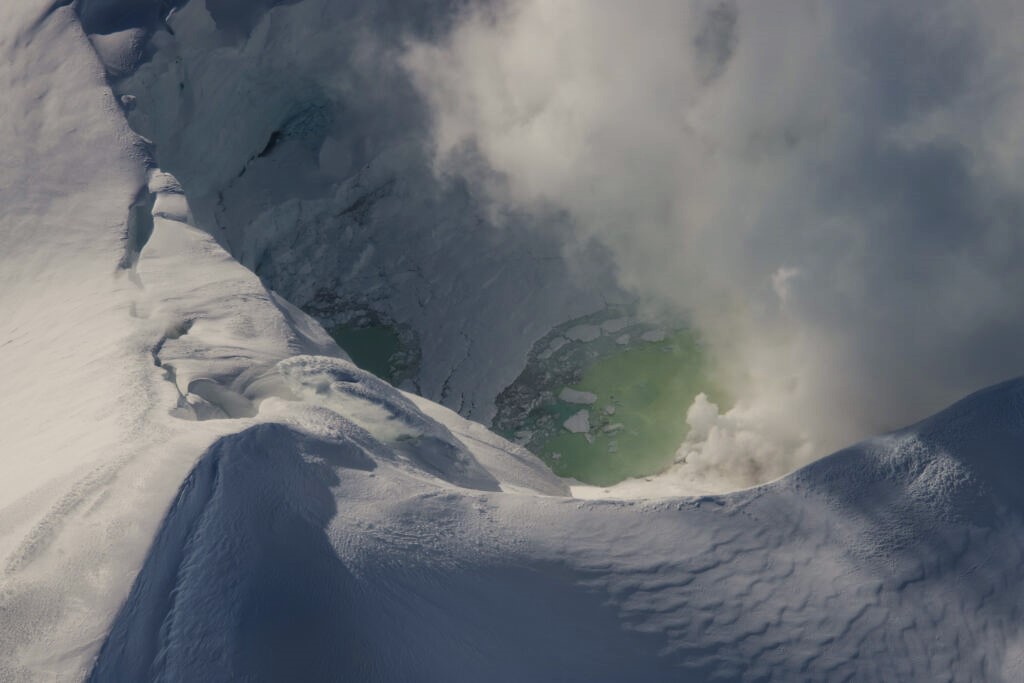
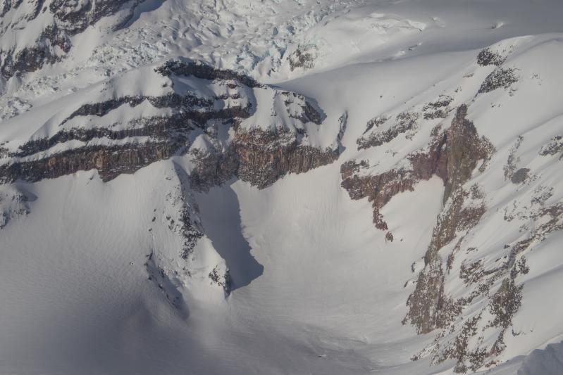
Summit crater of Mount Spurr, as seen during a gas measurement flight on March 7th, 2025. The fumaroles and open water are on the north side of the crater.
Recent observations
During an overflight on Friday, March 7, AVO measured about 450 metric tons per day of SO2 from the Spurr summit vent (figure). This is an increase from less than 50 metric tons per day SO2 measured in December 2024.
AVO also measured increased concentrations of CO2 at the summit and at the Crater Peak vent, 2 miles (3.5 km) south of the summit. The CO2 concentrations at Crater Peak were especially high. In the past, such values have been observed prior to eruptions (for example, at Redoubt Volcano in 2009). Preliminary results from a gas flight on March 11 confirm these results.
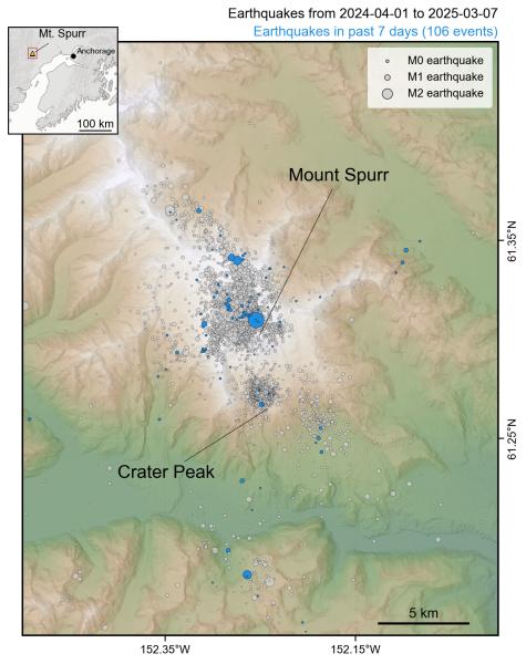
Over the last month, AVO has located over 100 earthquakes per week under Mount Spurr (figure). Most earthquakes are shallow (less than 2.5 miles, or 4 km, below sea level). Magnitudes during this time are as large as M2.7 (figure). Over 3400 earthquakes have been located under the volcano since April 2024.
Ground deformation also continues. The total movement away from the volcano to date is about ~2.6 inches (~6.5 cm) at the closest GNSS (GPS) station. Modeling of the inflation suggests a source around 2 to 3 miles (3 to 5 km) below sea level and about 2 miles (3 to 4 km) west of Mount Spurr summit.
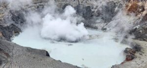
Collapse of snow and ice into the summit crater lake that formed during this period of unrest continues, along with steam emissions from fumaroles within and around the summit crater. New diffuse steaming from small snow-free spots within Crater Peak was observed beginning on March 6 (photo). These locations have been sporadically snow-free for years, but steaming has not been observed since 2008.
Interpretations and Hazards
The current unrest at Mount Spurr indicates that new magma has intruded into the Earth’s crust beneath the volcano and that the probability of an eruption has increased. It is likely that magma has been accumulating beneath Mount Spurr summit for some months. The recent gas data suggest that a new pathway towards the Crater Peak vent has opened, and that fresh magma may rise and erupt there. Crater Peak is the site of all historical eruptions. The last known eruption from Spurr summit occurred several thousand years ago.
Based on all available monitoring data, AVO regards the following scenarios as possible. We consider scenario 1, explosive eruption(s) like those in 1953 and 1992, as most likely at this time. Scenarios 2 and 3 (smaller eruption, or no eruption) are possible but considered less likely, and the likelihood of a much larger eruption is currently low.
View of Crater Peak from the east, as seen during a gas measurement flight on March 7th, 2025. Several fumaroles can be seen along two ridges on the west side of the crater. Crater Peak is the southern vent of Mount Spurr and the location of the two most recent eruptions in 1992 and 1953.
Explosive eruption(s) like those in 1953 and 1992: In this scenario, one or more explosive events, each lasting as long as a few hours, would produce ash clouds carried downwind for hundreds of miles and minor (up to about ¼ inch) ashfall over southcentral Alaska. The flanks of Mount Spurr likely would be swept by pyroclastic flows (hot avalanches) and impacted by ballistic showers. Mudflows (lahars) could inundate the upper Chakachatna River valley.
Lava-forming and/or small explosive eruption(s): It is possible that the volcano could erupt less explosively than it did in 1992 and 1953, and produce lava flows, a lava dome, and/or brief explosive eruptions. Such events would have less far-travelled impacts, but lahars (mudflows) in the drainages around the volcano are possible.
Failed eruption: If the magma stalls and does not reach the surface, as happened in 2004–2006, we expect to see earthquake activity, ground deformation, gas emissions, and surface heating slowly decrease over several weeks or months.
Large explosive eruption: Eruption(s) larger than those in 1992 and 1953 could occur. These would likely result in larger ash clouds, thicker ashfall deposits and greater overall impacts. No such eruptions are known in historical times, and the geologic record suggests these are rare. Therefore, the likelihood of such an event is low.
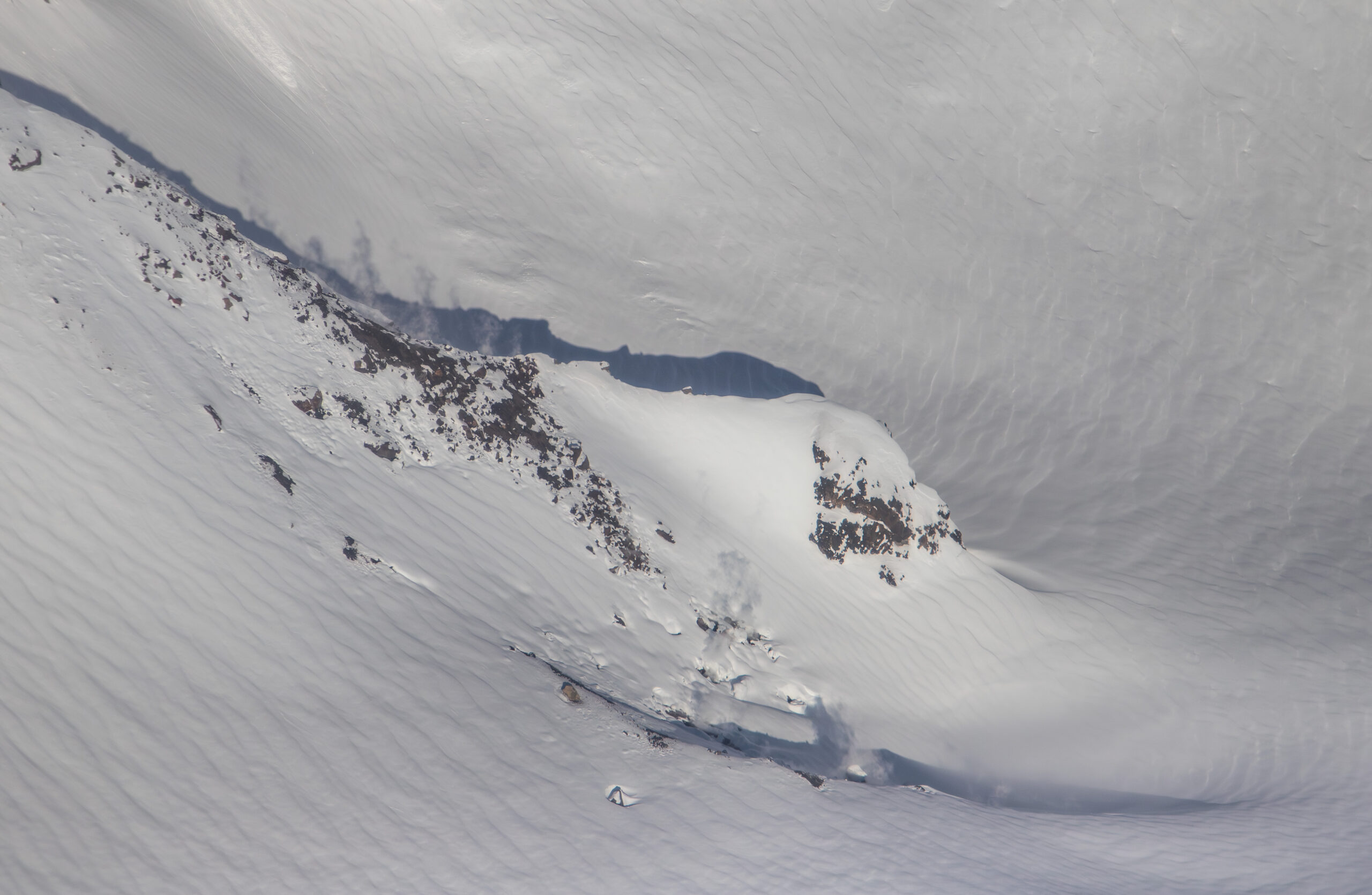
Several fumaroles steaming inside Crater Peak, the southern vent of Mount Spurr and the location of the two most recent eruptions in 1992 and 1953.
We cannot assign an exact timeframe for when an eruption will occur, if it does, but the increased gas emissions recorded on March 7 suggest that an eruption may occur in the next few weeks to months. We expect to see additional changes to monitoring data prior to an eruption, if one were to occur, as magma moves closer to the surface. This would include a change in the rate and character of earthquakes, onset of sustained seismic tremor, further increased gas emissions, changes in surface deformation, and melting of snow and ice. In 1992, such changes occurred about three weeks prior to the first eruption.
Should earthquake activity or other monitoring data suggest that an eruption is likely within hours or days, AVO would raise Mount Spurr from its current Aviation Color Code Yellow and Alert Level Advisory to Aviation Color Code Orange or Red and Alert Level Watch or Warning. Alert level definitions can be found here: Alaska Volcano Observatory | Volcano Alert Levels.
Decreases in earthquake activity, degassing, and surface deformation would make it less likely that the unrest will progress to eruption
Source : AVO
Photo : AVO/USGS , Mitchell, Mitch / AVO/USGS
Indonesia , Ibu :
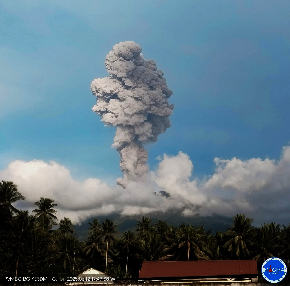
An eruption of Mount Ibu occurred on Wednesday, March 12, 2025, at 5:44 PM WIT with an observed ash column height of ± 1200 m above the peak (± 2525 m above sea level). The ash column was observed to be gray in color with a thick intensity, oriented toward the south. This eruption was recorded on a seismograph with a maximum amplitude of 28 mm and a duration of 75 seconds.
VOLCANO OBSERVATORY NOTICE FOR AVIATION – VONA
Issued : March 12 , 2025
Volcano : Ibu (268030)
Current Aviation Colour Code : ORANGE
Previous Aviation Colour Code : orange
Source : Ibu Volcano Observatory
Notice Number : 2025IBU521
Volcano Location : N 01 deg 29 min 17 sec E 127 deg 37 min 48 sec
Area : North Maluku, Indonesia
Summit Elevation : 4240 FT (1325 M)
Volcanic Activity Summary :
Eruption with volcanic ash cloud at 08h44 UTC (17h44 local).
Volcanic Cloud Height :
Best estimate of ash-cloud top is around 8080 FT (2525 M) above sea level or 3840 FT (1200 M) above summit. May be higher than what can be observed clearly. Source of height data: ground observer.
Other Volcanic Cloud Information :
Ash cloud moving to south. Volcanic ash is observed to be gray. The intensity of volcanic ash is observed to be thick.
Remarks :
Eruption recorded on seismogram with maximum amplitude 28 mm and maximum duration 75 second.
Source et photo : Magma Indonésie.
Guatemala , Fuego :
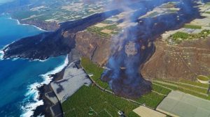
The Instituto Nacional de Sismología, Vulcanología, Meteorología e Hidrología (INSIVUMEH) reported that elevated eruptive activity at Fuego was characterized by explosions and ash plumes, incandescent material ejected above the summit, incandescent avalanches, and pyroclastic flows. The stronger activity began at around 02h55 on 9 March with explosions detected in seismic and acoustic data and increasing thermal radiance at the summit detected in satellite data. Explosions ejected incandescent material onto the upper flanks on all directions and caused avalanches of incandescent material. Explosions and gas ejections were heard in areas several kilometers away. According to the Washington VAAC significant ash plumes rose about 1.1 km above the summit at 03h50, but by 09h30 the plumes were more sporadic and diffuse; the plumes drifted W and NW. INSIVUMEH noted that activity intensified in the early evening and became continuous. The VAAC reported that at 16h20 ash plumes rose around 500 m above the summit and drifted W. At around 18h00 air quality monitoring stations in Guatemala City recorded decreased quality conditions due to ash in the air, according to CONRED. The VAAC reported that at 2200 dense ash emissions rose 500 m and drifted 150 km SW while a second plume rose 1.1 km above the summit and drifted NW.
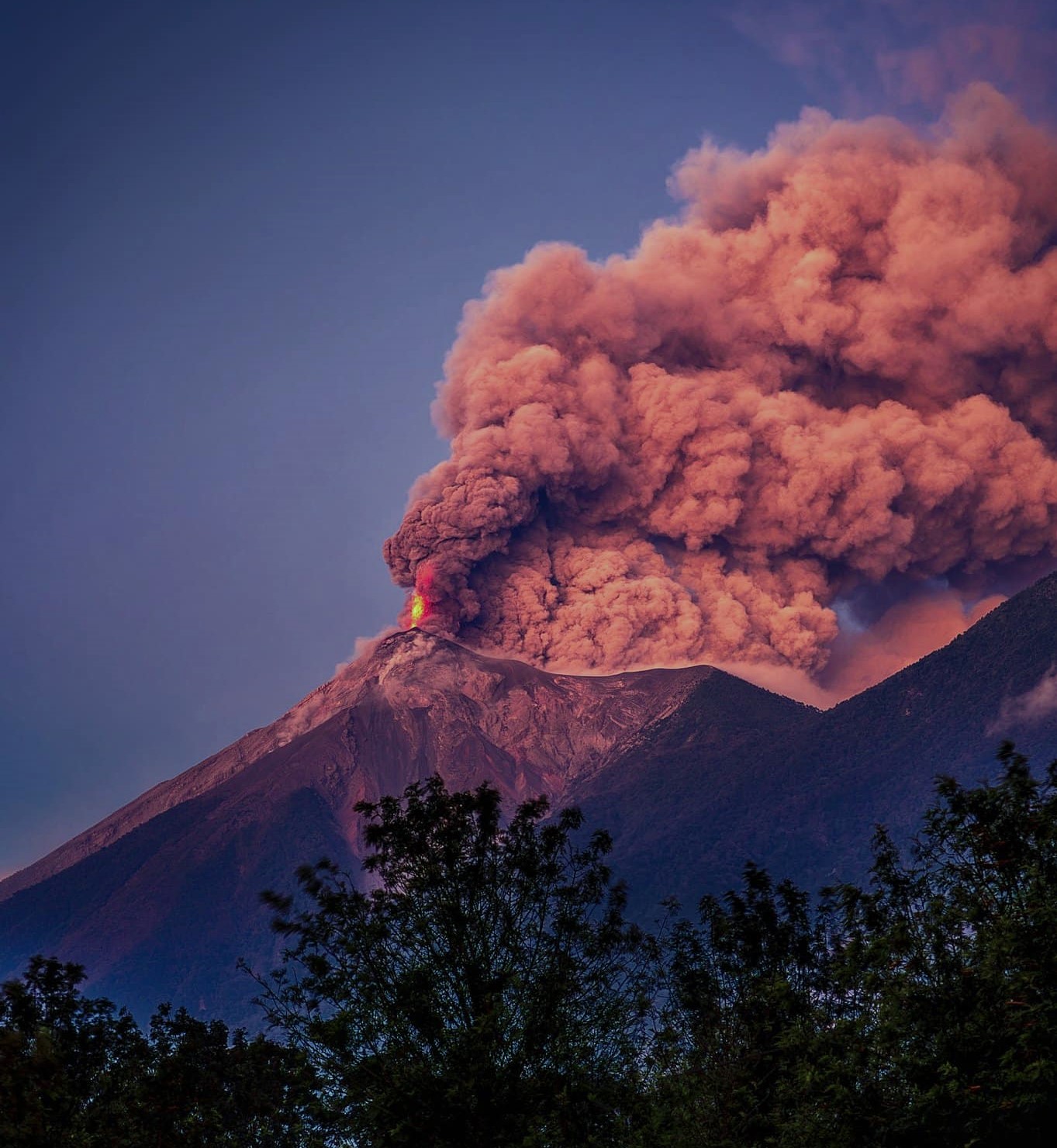
Activity notably intensified again at 2100 on 9 March. Lava fountains rose 300 m above the summit, avalanches of incandescent blocks descended the flanks, and shockwaves from explosions rattled nearby houses and structures. Ash plumes rose 3.2 km above the summit and fanned out as far as 50 km SW, W, and NW. Continuous ashfall was reported in areas W and S. Just before 23h30 pyroclastic flows descended the Seca (W) and Ceniza (SSW) drainages and about 25 minutes later pyroclastic flows descended the Las Lajas (SE) and El Jute (ESE) drainages. CONRED staff assisted 267 people from El Porvenir and 15 from Las Lajitas to an evacuation shelter in the Municipal Hall of San Juan Alotenango, Sacatepéquez. A section of the RN-14, the national route connecting Escuintla and Sacatepéquez, was temporarily closed as a preventative measure.
Overnight during 9-10 March lava fountains rose 500 m high. Dense ash-and-gas plumes rose 6 km above the summit and drifted 100-120 km NW and E. Low-altitude plumes with ash remobilized from earlier pyroclastic flows drifted SW. On 10 March the Ministry of Education suspended classes in the municipalities of Alotenango, Sacatepéquez; Escuintla and Siquinalá in the department of Escuintla; and in San Pedro Yepocapa, Chimaltenango. Activity began to decrease and by 11h30 on 10 March explosions were no longer continuous. Ash-and-gas plumes rose 1.1 km above the summit and drifted 100 km NW and SW.

Minor ashfall continued to impact areas to the W and SW; ash remained suspended in the air and ashfall on crops was up to 1 mm thick. By 12h30 the air quality monitoring station in Guatemala City recorded improved quality conditions due to less ash in the air. Activity continued to decline. INSIVUMEH issued a report at 18h00 noting that activity had returned to “baseline” levels; seismicity was at “normal” levels and satellite data indicated that large amounts of ash were no longer suspended in the air. Thermal anomalies were also no longer detected in satellite data. Overnight during 10-11 March a few incandescent blocks in the crater were visible along with minor avalanches of incandescent material. Diffuse gas emissions rose form the crater. During 11-12 March gas emissions rose about 100 m above the summit and no incandescent explosions were observed.
Sources : Instituto Nacional de Sismologia, Vulcanologia, Meteorologia, e Hidrologia (INSIVUMEH), Coordinadora Nacional para la Reducción de Desastres (CONRED) , GVP .
Photos : David Rojas / FB. EFE noticias / FB.
Costa Rica , Poas :
The Observatorio Vulcanológico y Sismológico de Costa Rica-Universidad Nacional (OVSICORI-UNA) reported that eruptive activity at Poás intensified during 1-2 March and continued at a high level through 11 March. Frequent phreatic eruptions during 4-7 March ejected material as high as 50 m above the crater floor. The phreatic eruptions were almost continuous at Boca C and sporadic and Boca A. Radial deformation and inflation was detected in and around the crater, and the rate of deformation was increasing. The lake level had dropped, and the water was separated into two small ponds. An analysis of monitoring data suggested that there were disturbances of the magmatic system at depth which increased the probability of dangerous eruptions within the Parque Nacional Volcán Poás within the next few days or weeks. At 13h30 on 7 March the Alert Level was raised to 3 (the second highest level on a four-level scale) and the Aviation Color Code was raised to Orange (the second highest color on a four-color scale).
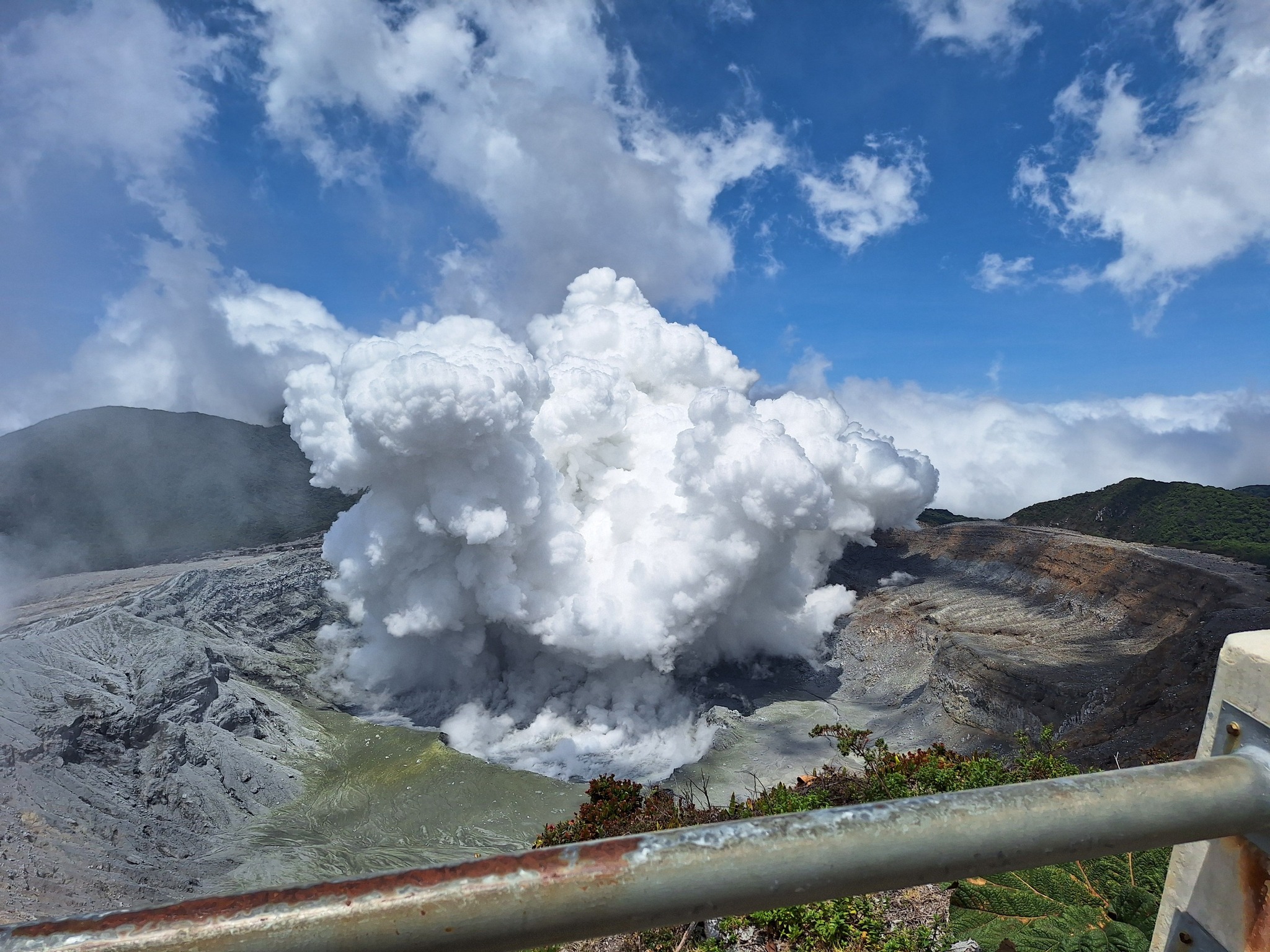
Small frequent phreatic eruptions, mostly at Boca C, continued during 8-9 March. In a special report issued at 10h00 on 9 March OVSICORI-UNA reported that two shock waves identified in infrasound data signified an eruptive event. Steam plumes rose several hundred meters and material was likely ejected as high as 200 m above the vent, though visual confirmation was obscured by the plumes. Phreatic eruptions at 10h53, 12h36, and 18h21 on 9 March generated gas-and-steam plumes that rose as high as 1 km; the plumes obscured views of the crater. Sulfur dioxide emissions detected in satellite data averaged 538 tons per day. Notably, during the evening, eight volcano-tectonic events associated with rock fracturing were recorded in both seismic and infrasound data. Activity continued during 9-10 March mainly from Boca C and some from Boca A. The phreatic eruptions ejected material 200-400 m above the crater floor and generated steam-and-gas plumes that rose as high as 1 km. The ponds continued to shrink and the water had a high sediment content. Blocks up to 1 m in diameter were ejected from the vents onto the crater floor and sediments rich in native sulfur were deposited around the edges of the small ponds. Eruptive activity continued on 11 March at similar levels, moderate- to high-level tremor was recorded, and inflation continued.
Sources: Observatorio Vulcanologico y Sismologico de Costa Rica-Universidad Nacional (OVSICORI-UNA), GVP.
Photo : Peter Mertsch / FB.
Japan , Suwanosejima :
The Japan Meteorological Agency (JMA) reported that eruptive activity at Suwanosejima’s Ontake Crater continued during 3-10 March. Incandescence was observed nightly in webcam images. Eruptive activity generated emissions that rose 800 m above the crater rim. No changes around the crater were observed during a 5 March aerial observation. The Alert Level remained at 2 (the second level on a five-level scale) and the public was warned to stay at least 1.5 km away from the crater
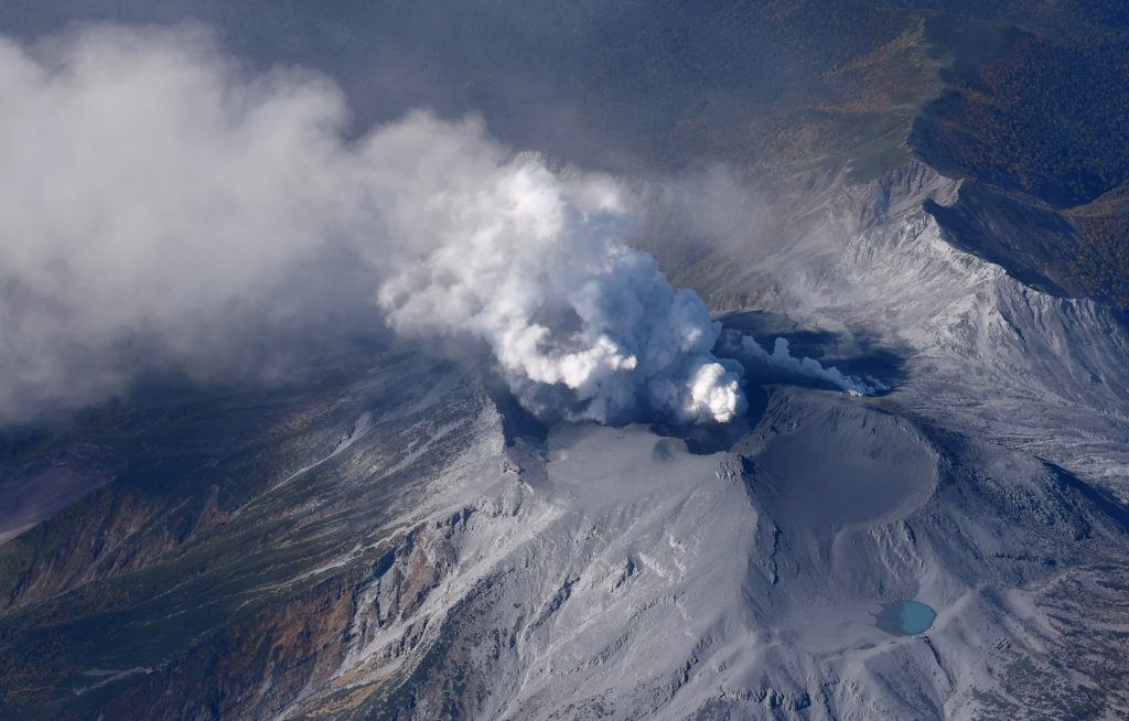
The 8-km-long island of Suwanosejima in the northern Ryukyu Islands consists of an andesitic stratovolcano with two active summit craters. The summit is truncated by a large breached crater extending to the sea on the E flank that was formed by edifice collapse. One of Japan’s most frequently active volcanoes, it was in a state of intermittent Strombolian activity from Otake, the NE summit crater, between 1949 and 1996, after which periods of inactivity lengthened. The largest recorded eruption took place in 1813-14, when thick scoria deposits covered residential areas, and the SW crater produced two lava flows that reached the western coast. At the end of the eruption the summit of Otake collapsed, forming a large debris avalanche and creating an open collapse scarp extending to the eastern coast. The island remained uninhabited for about 70 years after the 1813-1814 eruption. Lava flows reached the eastern coast of the island in 1884. Only about 50 people live on the island.
Sources: Japan Meteorological Agency (JMA) , GVP.
Photo : Masanori Genko