March 11 , 2025 .
Guatemala , Fuego :
14°28’54˝ North latitude;
90°52’54˝ West longitude
Height: 3,763 meters
Weather conditions: Clear.
Wind: Southwest.
Precipitation: 0.0 mm.
Activity:
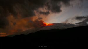
The effusive eruption of the Fuego volcano continues, producing an incandescent fountain 500 meters high above the crater, as well as dense columns of gas and ash that reach 6,000 meters above sea level (19,685 feet). The ash is dispersed towards the northwest and west, covering distances of between 100 and 120 km. In addition, due to the recent pyroclastic flows generated in the different ravines of the volcano, the presence of ash at low altitude is observed, which is remobilized by the wind in a southwesterly direction. This eruptive activity could persist in the coming hours or days, which does not exclude the possibility of new pyroclastic flows, especially towards Barranca Seca, as well as the continued fall of fine ash in the surrounding communities. The explosions generate rumblings and shock waves. It is recommended to follow the instructions of the special bulletin BEFGO-006-2025 and to stay tuned to the special bulletins and ash dispersion maps issued by INSIVUMEH.
The National Institute of Volcanology, Meteorology and Hydrology -INSIVUMEH-, reported on the morning of March 9, 2025, a new eruptive period of the Fuego Volcano, after 40 days of inactivity.
According to monitoring, a strong explosion was identified with a duration of 7 minutes, thus presenting an increase above normal parameters of the seismic wave, average seismic amplitude and infrasound. For this reason, INSIVUMEH activated the Multi-Threat Management Committee to unify multidisciplinary actions and activate institutional monitoring protocols.
The activity of the volcano is characterized by a fountain of incandescent lava reaching up to 500 meters high, columns of gas and ash that reach 700 meters in altitude, avalanches and lava flows in different directions and pyroclastic flows that travel several kilometers below in the ravines of the volcano towards Las Lajas and Jute.
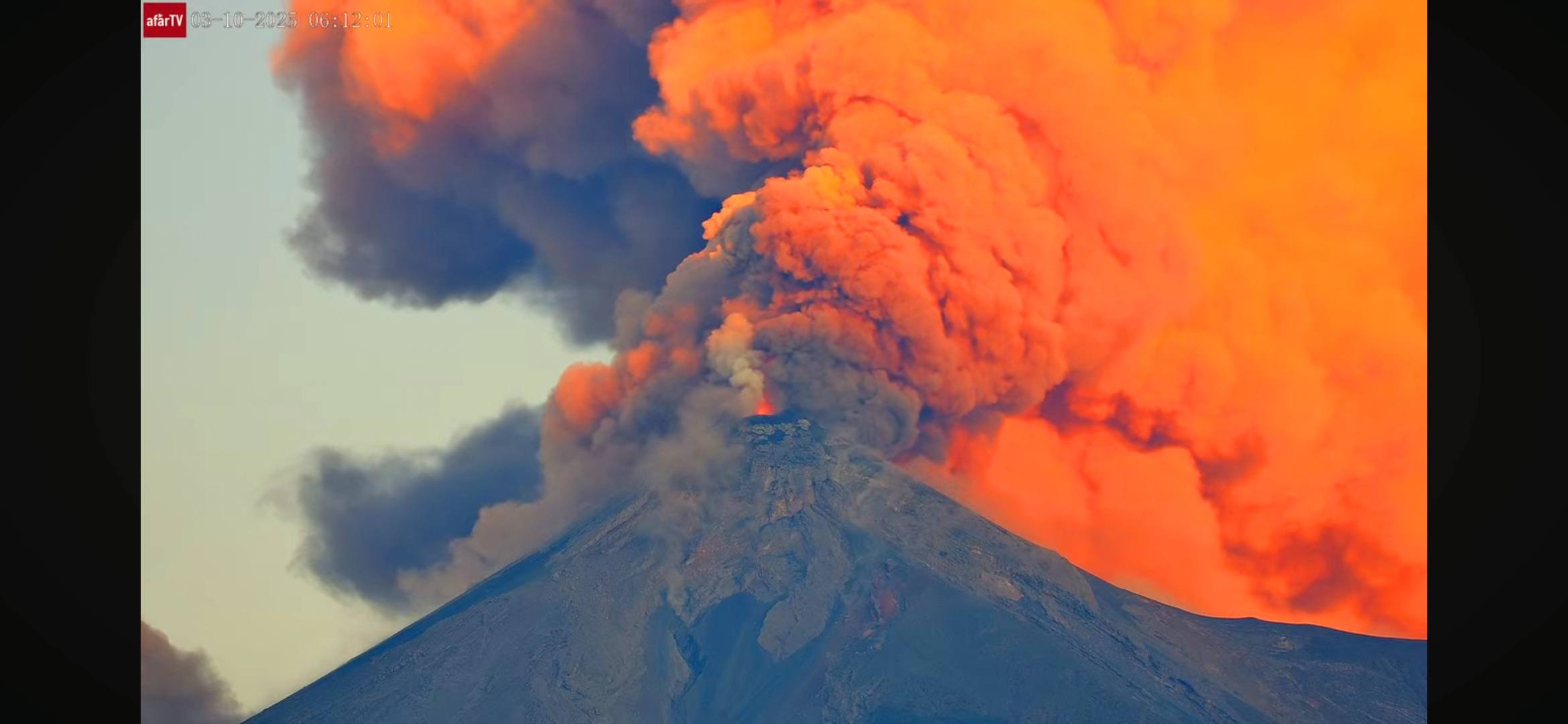
Among the affected departments are Chimaltenango, Sacatepéquez, Escuintla, Sololá and Totonicapán. A column of ash measuring seven thousand meters has also been reported, as well as a displacement of volcanic material that can reach up to 40 kilometers in distance.
The last update was made at 11:30 a.m. on Monday, which, through the INSIVUMEH bulletin, indicates a decrease in eruptive intensity, but the emissions of gas and ash persist up to 4,800 meters above sea level. The explosions have decreased in frequency, although the « locomotive » type noises reported by neighboring communities persist, and satellite and webcam images confirm the fall of ash.
INSIVUMEH maintains visual and instrumental monitoring of the phenomenon with field observers, seismic stations, infrasound stations and satellite monitoring. The population is advised to stay informed and follow the instructions of the authorities.
Source : Insivumeh.
Photos : afar tv via Ca Ba /FB.
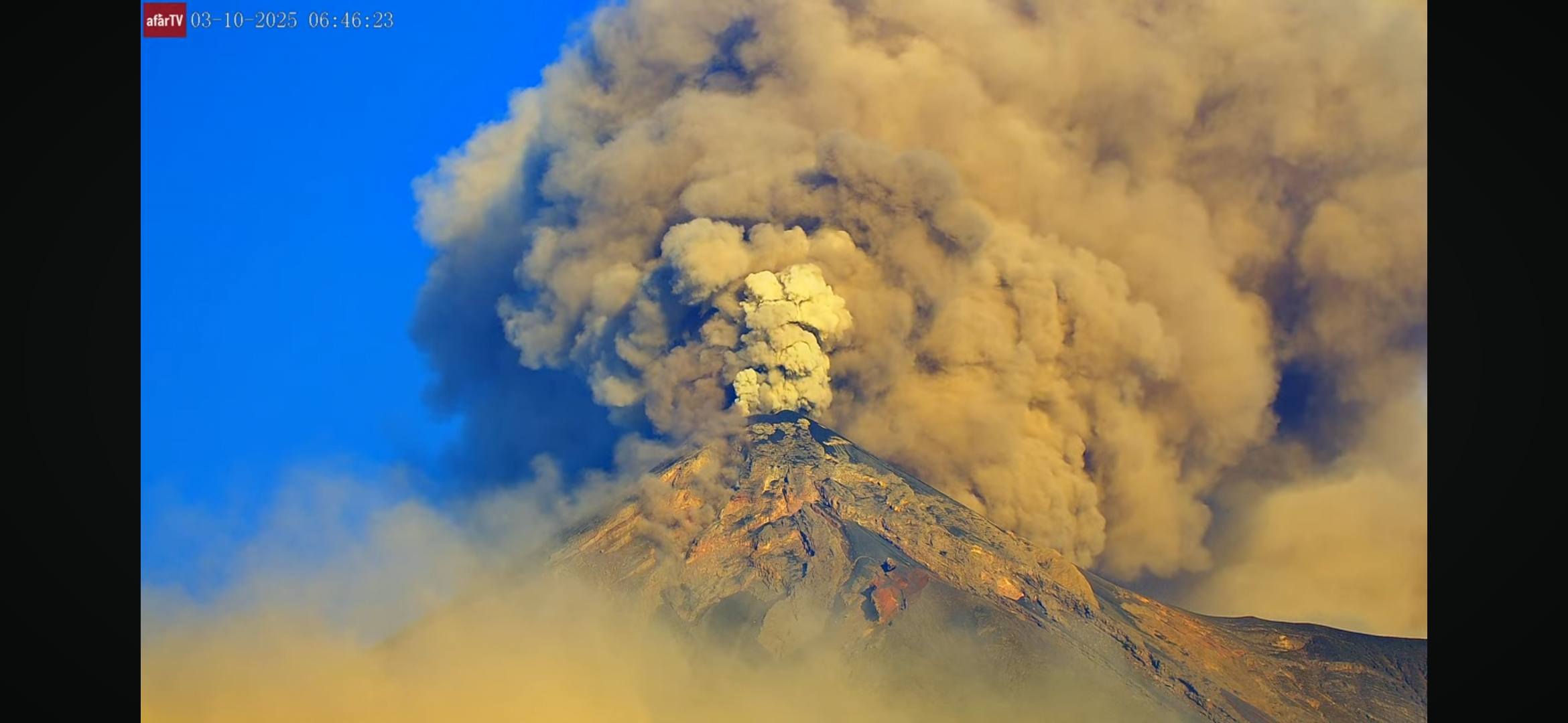
Indonésie , Lewotobi Laki-laki :
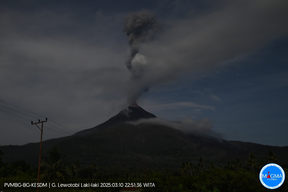
Une éruption du mont Lewotobi Laki-laki s’est produite le lundi 10 mars 2025 à 22h48 WITA avec une hauteur de colonne de cendres observée de ± 2000 m au-dessus du pic (± 3584 m au-dessus du niveau de la mer). La colonne de cendres a été observée comme étant de couleur grise avec une intensité épaisse , orientée vers l’Ouest et le Nord-Ouest. Cette éruption a été enregistrée sur un sismographe avec une amplitude maximale de 18,5 mm et une durée de 102 secondes.
VOLCANO OBSERVATORY NOTICE FOR AVIATION – VONA
Issued : March 1 ,20250310/1448Z
Volcano : Lewotobi Laki-laki (264180)
Current Aviation Colour Code : ORANGE
Previous Aviation Colour Code : orange
Source : Lewotobi Laki-laki Volcano Observatory
Notice Number : 2025LWK124
Volcano Location : S 08 deg 32 min 20 sec E 122 deg 46 min 06 sec
Area : East Nusa Tenggara, Indonesia
Summit Elevation : 5069 FT (1584 M)
Volcanic Activity Summary :
Eruption with volcanic ash cloud at 14h48 UTC (22h48 local).
Volcanic Cloud Height :
Best estimate of ash-cloud top is around 11469 FT (3584 M) above sea level or 6400 FT (2000 M) above summit. May be higher than what can be observed clearly. Source of height data: ground observer.
Other Volcanic Cloud Information :
Ash cloud moving from west to northwest. Volcanic ash is observed to be gray. The intensity of volcanic ash is observed to be thick.
Remarks :
Eruption recorded on seismogram with maximum amplitude 18.5 mm and maximum duration 102 second.
Source et photo : Magma Indonésie .
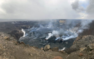
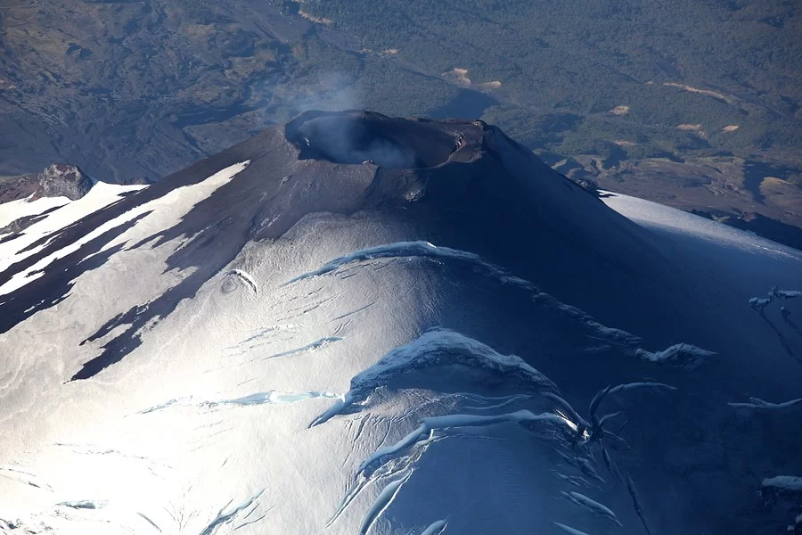
Chile , Villarica :
Seismology
The seismological activity of the period was characterized by the recording of:
A continuous seismic tremor signal associated with the fluid dynamics inside the volcano, which during this period presented energy ranges between 0.1 and 0.2 μm/s, evaluated with the RSAM parameter.
6 VT-type seismic events, associated with rock fracturing (Volcano-Tectonic). The most energetic earthquake had a local magnitude (ML) value equal to 0.7, located 6.0 km south-southeast of the volcanic edifice, at a depth of 4.0 km.
2437 LP-type seismic events, associated with the fluid dynamics within the volcanic system (Long Period). The size of the largest earthquake evaluated using the reduced displacement (DR) parameter was equal to 16 cm2.
56 TR-type seismic events, associated with sustained fluid dynamics within the volcanic system (TRemor). The size of the largest earthquake estimated from the reduced displacement parameter (DR) was equal to 4 cm2.
Fluid Geochemistry
Data on sulfur dioxide (SO2) emissions obtained using the Differential Optical Absorption Spectroscopy (DOAS) equipment, corresponding to the Los Nevados and Tralco stations, installed respectively 10 km east-northeast and 6 km east-southeast of the active crater, showed an average value of 434 ± 56 t/d for the month of February. These values are considered normal for this volcanic system. The highest daily average of the month was 1,079 t/d on February 22.
No anomalies in sulfur dioxide (SO2) emissions into the atmosphere have been reported in the area near the volcano, according to data published by the Tropospheric Monitoring Instrument (TROPOMI) and the Ozone Monitoring Instrument (OMI) Sulfur Dioxide Group.
Geodesy
According to the data provided by the GNSS network, which measures the deformation of the volcano, a period of stability can be observed in the system, highlighted by its low displacement rates, both horizontally and vertically, which do not exceed 0.6 cm/month. No obvious deformation of the volcano is observed in the radar interferometry (InSAR) data, data available on the MOUNTS platform.
Thermal anomalies by satellites
During this period, thermal radiation anomalies were recorded in the area associated with the volcano crater, according to the analytical processing of Sentinel 2-L2A and Landsat 8-9 satellite images, in combination with false-color bands. The thermal radiation area is 2,800 m2 (normalized hotspot indices algorithm [Marchese et al., 2019]). No thermal alert was recorded according to the data processed by the Mid-Infrared Observation of Volcanic Activity (MIROVA).
Source : Sernageomin.
Photo : Aton
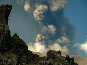
Peru , Sabancaya :
Analysis period: from March 03, 2025 to March 09, 2025, Arequipa, March 10, 2025
Alert level: ORANGE
The Geophysical Institute of Peru (IGP) reports that the eruptive activity of the Sabancaya volcano continues. During this period, an average of 0 explosions per day have been recorded, with columns of ash and gas up to 600 m above sea level above the summit of the volcano. Therefore, the volcanic alert level remains at ORANGE
The IGP has recorded and analyzed the occurrence of 15 earthquakes of volcanic origin, associated with the circulation of magmatic fluids inside the Sabancaya volcano, as well as earthquakes related to rock fracturing. During this period, no explosions have been recorded.

Columns of ash and gas were observed up to 600 m above the summit of the volcano. The predominant direction of these emissions was towards the West, South-West and North-West sector of the volcano over a distance of less than 10 KM.
No significant deformation of the volcanic edifice was recorded.
No thermal anomalies were identified.
Moderate emissions (236 tons/day) of sulfur dioxide (SO2) were observed
RECOMMENDATIONS
• Keep the orange volcanic alert level.
• Do not approach within a radius of less than 12 km from the crater.
Source : Cenvul
Photo : Zintia Roxana Fernández Licla
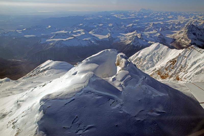
Alaska , Spurr :
Unrest continues at Mount Spurr. Seismicity remains elevated with numerous small, shallow volcanic earthquakes detected beneath the volcano. Cloudy conditions obscured satellite views of the volcano over the past day. Cloudy conditions and ice accumulation obscured webcam views of the volcano.
AVO continues monitoring activity at Mount Spurr for signals indicating that the volcano is moving closer to an eruption. Based on previous eruptions, changes from current activity in the earthquakes, ground deformation, summit lake conditions, and fumarolic activity would be expected if magma began to move closer to the surface. Therefore, if an eruption occurred, it would be preceded by additional signals allowing warning.
The volcano is monitored using local seismic, infrasound, web camera, and GNSS stations along with regional infrasound, lightning networks and satellite data.
Source : AVO
Photo : McGimsey, Game ( 2016)