February 24 , 2025.
Italy / Sicily , Etna :
VOLCANO OBSERVATORY NOTICE FOR AVIATION (VONA)
Issued: February 23 ,2025
Volcano: Etna 211060
Current Color Code: ORANGE
Previous Color Code: orange
Source: Etna Volcano Observatory
Notice Number: 2025/0014/01N03
Volcano Location: 3744N 01500E
Area: Italy
Summit Elevation: 3300 m
Volcanic Activity Summary:
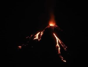
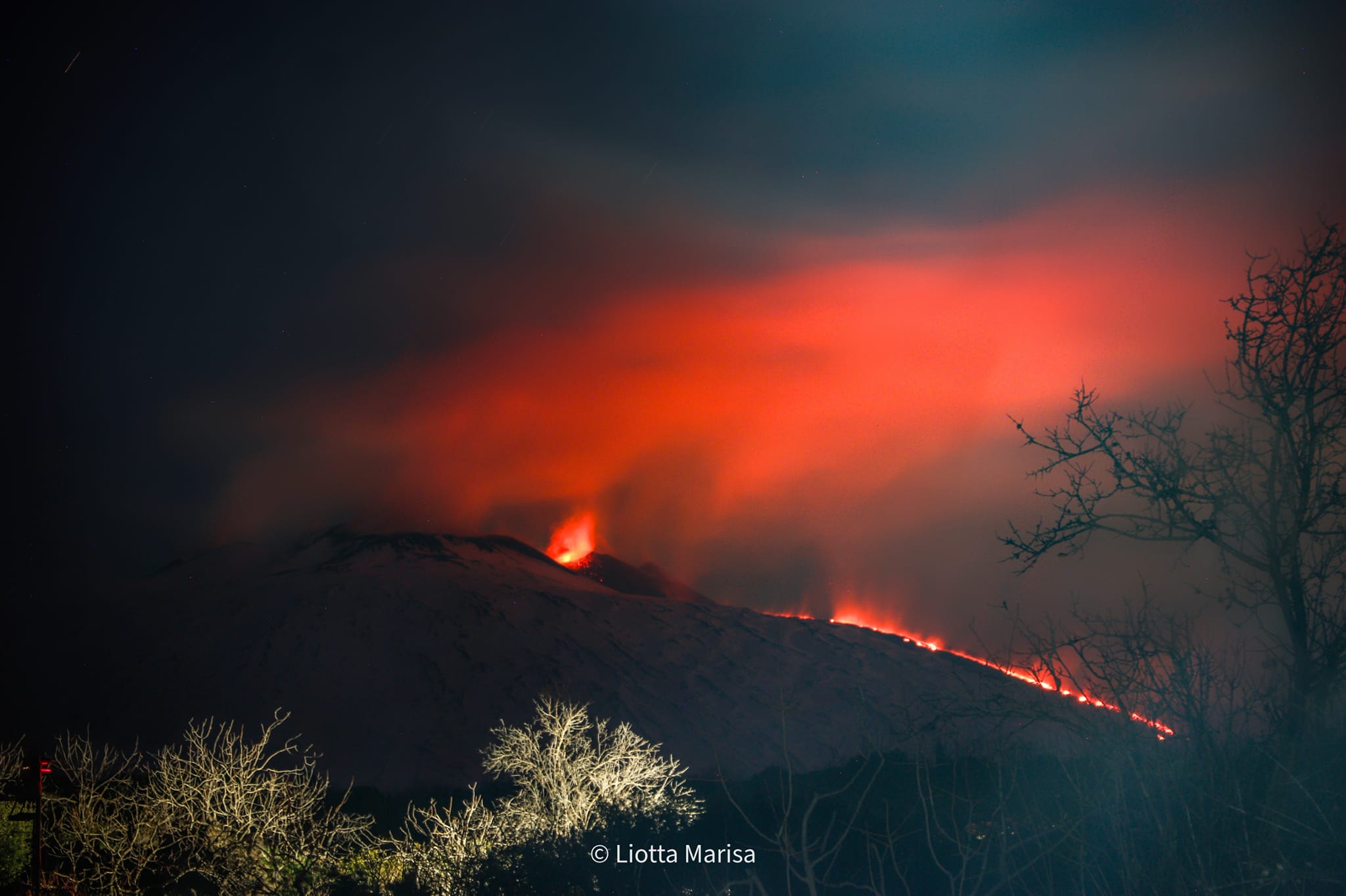
Strombolian activity is observed in the summit craters. A weak ash emission is in progress. A lava flow is still observed at the summit.
Volcanic cloud height:
NO ASH CLOUD IS PRODUCED
Other volcanic cloud information:
VOLCANIC ASH IS CONFINED TO THE SUMMIT AREA
Remarks:
THE PHENOMENON IS OBSERVED BY VISIBLE AND
THERMAL SURVEILLANCE CAMERAS
Next Notice:
A new VONA will be issued if conditions change significantly
or color code changes.
Source : INGV
Photo : Marisa Liotta
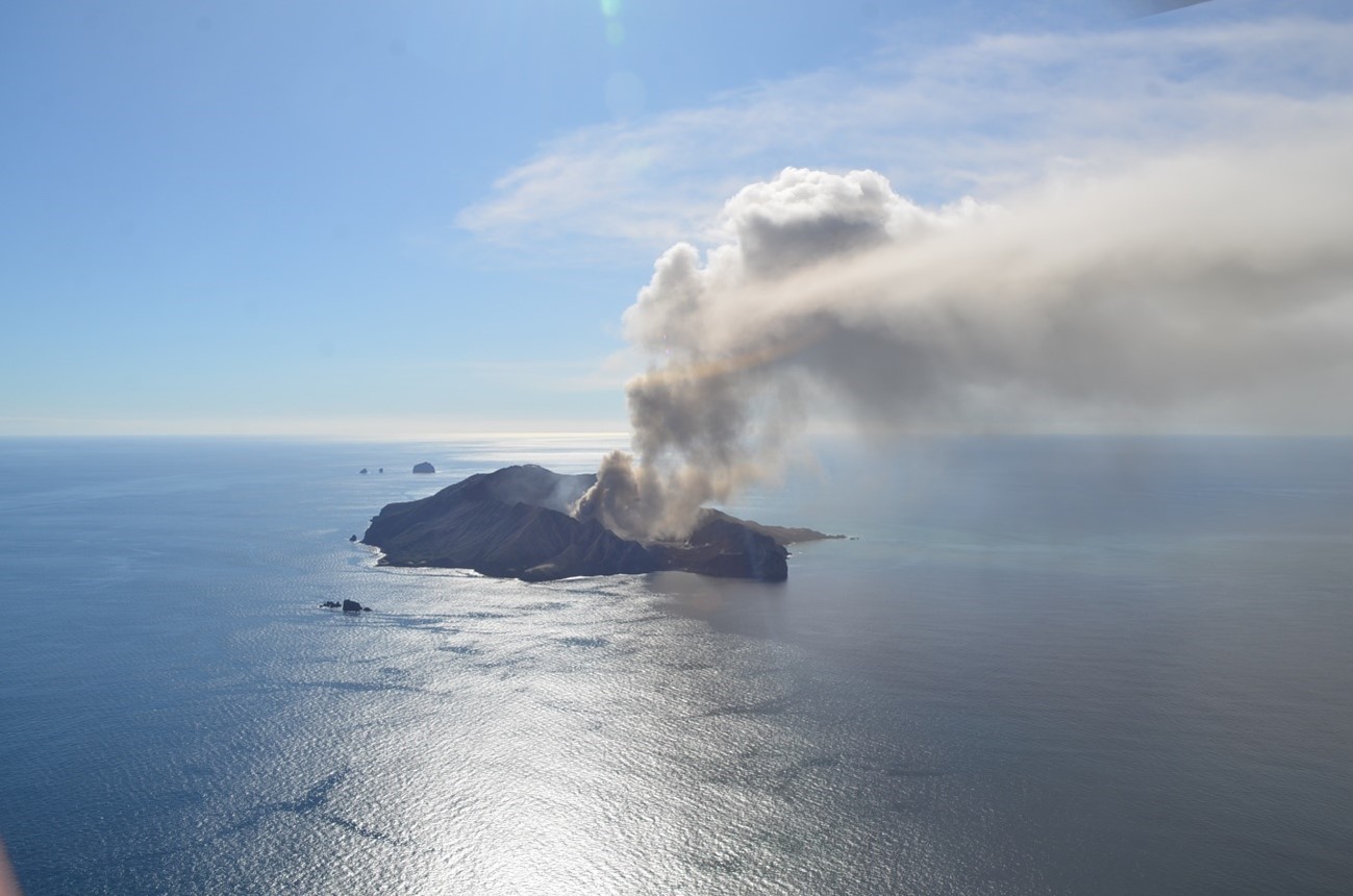
New Zealand , White island :
Volcanic Activity Bulletin . Mon Feb 24 2025 2:30 PM;
Volcanic Alert Level remains at 2
Aviation Colour Code is raised to ORANGE
Variable steam, gas and ash emissions observed at Whakaari / White Island. The Volcanic Alert Level remains at 2 and the Aviation Colour Code is changed to Orange.
Over the past week, large white, steam-rich plumes could be seen from our webcams at Whakatāne and Te Kaha. During the weekend, small amounts of volcanic ash were observed in the plume on satellite imagery by our colleagues at MetService which could also be seen as a faint haze from the coast.
On several days last week, sulphur dioxide (SO₂) emissions were detected by satellite which may have been noticed by residents on the coast as sulphur odours during northerly wind conditions.
Steam, gas, and ash emissions remain variable as they have been for the past few months. Recent activity is consistent with moderate-heightened unrest and the Volcanic Alert Level therefore remains at Level 2. Because of the recent observations of volcanic ash emissions from the volcano the Aviation Colour Code is raised to Orange. Due to the current lack of consistent, usable real-time monitoring data, there is considerable uncertainty about the current level of volcanic activity which could escalate with little or no warning.
GNS Science’s Volcano Monitoring Group and National Geohazards Monitoring Centre will continue to closely monitor Whakaari / White Island for any changes in activity. We will provide further updates when information becomes available.
Source : Geonet
Photo : Bradd Scott / Geonet
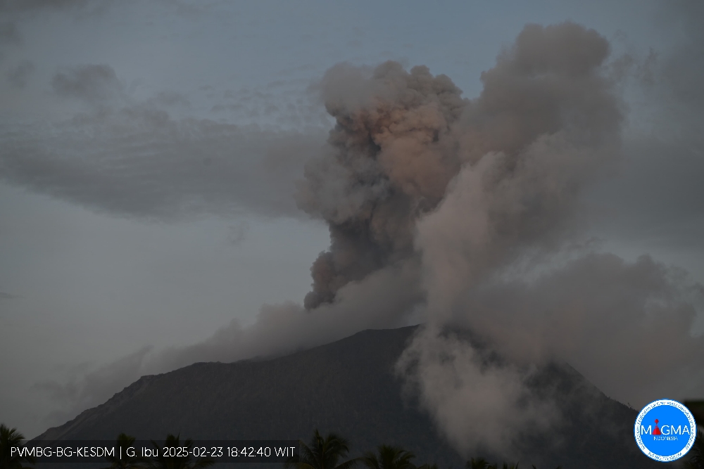
Indonesia , Ibu :
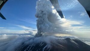
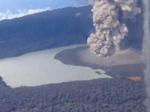
An eruption of Mount Ibu occurred on Sunday, 23 February 2025, at 13:01 UTC (22:01 local) with an observed ash column height of ±700 m above the peak (±2025 m above sea level). The ash column was observed to be grey in colour with a thick intensity, oriented towards the southwest. This eruption was recorded on a seismograph with a maximum amplitude of 28 mm and a duration of 139 seconds.
VOLCANO OBSERVATORY NOTICE FOR AVIATION – VONA
Issued : February 23 ,20250223/1301Z
Volcano : Ibu (268030)
Current Aviation Colour Code : ORANGE
Previous Aviation Colour Code : orange
Source : Ibu Volcano Observatory
Notice Number : 2025IBU398
Volcano Location : N 01 deg 29 min 17 sec E 127 deg 37 min 48 sec
Area : North Maluku, Indonesia
Summit Elevation : 4240 FT (1325 M)
Volcanic Activity Summary :
Eruption with volcanic ash cloud at 13h01 UTC (22h01 local).
Volcanic Cloud Height :
Best estimate of ash-cloud top is around 6480 FT (2025 M) above sea level or 2240 FT (700 M) above summit. May be higher than what can be observed clearly. Source of height data: ground observer.
Other Volcanic Cloud Information :
Ash cloud moving to southwest. Volcanic ash is observed to be gray. The intensity of volcanic ash is observed to be thick.
Remarks :
Eruption recorded on seismogram with maximum amplitude 28 mm and maximum duration 139 second.
Source et photo : Magma Indonésie .
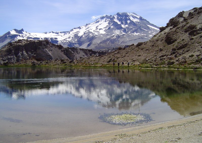
Chile , Descabezado Grande :
Special Report on Volcanic Activity (REAV), Del Maule Region, Descabezado Grande Volcanic Complex, February 23, 2025, 03:10 local time (Continental Chile)
The National Geology and Mining Service of Chile (Sernageomin) announces the following PRELIMINARY information, obtained through the monitoring equipment of the National Volcanic Monitoring Network (RNVV), processed and analyzed at the Volcanological Observatory of the Southern Andes (Ovdas):
On Sunday, February 23, 2025 at 03:03 local time (06:03 UTC), monitoring stations installed near the Descabezado Grande volcanic complex recorded an earthquake associated with the fracturing of rocks within the volcanic system (VT volcano-tectonic type).
The characteristics of the earthquake after its analysis are as follows:
TIME OF ORIGIN: 03:03 local time (06:03 UTC)
LATITUDE: 35.669° S
LONGITUDE: 70.750° W
DEPTH: 10.7 km
LOCAL AMPLITUDE: 3.2 (ML)
Observations:
No changes in the seismic behavior of the volcano were recorded after the event.
The volcanic technical alert remains at Green level.
Source : Sernageomin.
Photo : Wikiheinz
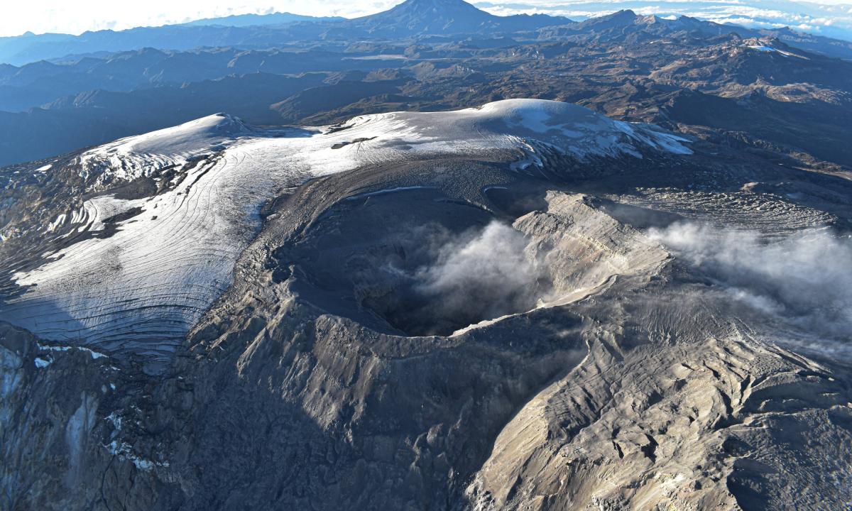
Colombia , Nevado del Ruiz :
Manizales, February 18, 2025, 5:45 p.m. .
Following the monitoring of the activity of the Nevado del Ruiz volcano, the Colombian Geological Survey (SGC), an entity attached to the Ministry of Mines and Energy, reports that:
During the week of February 11 to 17, 2025, the volcano continued to display unstable behavior. Compared to the previous week, the main variations in the monitored parameters were:
– Seismic activity associated with rock fracturing within the volcanic structure increased in the number of earthquakes recorded and decreased slightly in the seismic energy released. The earthquakes were located at distances of up to approximately 5 km from the Arenas crater, mainly in the West-Southwest area and, to a lesser extent, in the crater and to the Northeast, South and Southeast of the volcano. The depths of the events varied between 1 km and 7 km from the summit of the volcano. The greatest number of earthquakes was recorded on 11, 13 and 15 February in the southwest sector of the volcano. The highest magnitude of the week was 1.9, corresponding to the earthquake of 15 February at 00:00, located 5 km west-southwest of the volcanic structure, at a depth of 5 km. In addition, low-energy seismicity was recorded related to the activity of the lava dome (protuberance or mound) located at the bottom of the crater. – The recording of seismicity related to fluid dynamics in volcanic conduits continued, associated with long-period signals with mostly low to moderate energy levels. However, unlike the previous week, the duration of the signals was longer. The long-period signal of February 12 stands out, occurring between 03:01 and 15:01 and 06:46, as it was the highest energy level recorded since 2012. An increase in seismic signals associated with the emission of pulsatile ash was also observed. Thanks to the cameras (conventional or thermographic) used to monitor the volcano, it was possible to confirm several continuous and pulsatile ash emissions, as well as changes in the apparent temperature of the emitted material, related to some of these events.
– The emission of water vapor and gas, mainly sulfur dioxide (SO₂), into the atmosphere through the Arenas crater was variable and continued to show a decrease in the estimated SO₂ degassing values compared to previous weeks. This is partly due to the weather conditions and wind direction that did not favor the data collection by the measuring instruments installed on the volcano.
However, satellite monitoring, carried out in a complementary manner to evaluate this parameter, continues to show significant SO₂ releases into the atmosphere.
– The height of the gas or ash column reached a maximum value of 2300 m vertically and 2600 m in dispersion. These values measured at the volcanic summit were estimated during the ash emission on February 13 at 04:22. Regarding the direction of dispersion of the column, it showed a predominant trend towards the West-Southwest of the volcano throughout the week.
– In the context of monitoring thermal anomalies at the bottom of the Arenas crater, from satellite monitoring platforms, some anomaly reports were obtained with low energy levels.
Source et photo : SGC.