February 15 , 2025.
Alaska , Spurr :
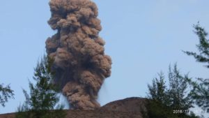
Volcanic unrest continues at Mount Spurr. More than 80 earthquakes were located under Mount Spurr during the past week which is a decrease from the previous week when over 200 earthquakes were located. These small (mostly less than magnitude 1) events were located both under the north side of the Spurr Summit as well as Crater Peak, the flank vent south of the summit that was the site of the 1953 and 1992 eruptions. Data from GNSS stations show that outward inflation continues at about the same rate as has been occurring since spring of 2024. An AVO field crew did an overflight of the volcano on February 7. Thus far we see no obvious changes at the Crater Peak vent. The ice-filled crater lake at the Spurr summit is still present but is reduced slightly in water depth and surface area and a high-temperature fumarole field is visible on the north shore of the crater lake. Infrared images of the fumarole field show temperatures as high as 320 degrees F (160 degrees C). Although conditions were not ideal for measuring gas during the February 7 overflight, data that were collected show no significant changes in gas output from the volcano. Sulfur dioxide and carbon dioxide gas are similar to background levels measured in previous years. Clear views of the volcano by satellite and web cameras much of this week showed steaming from summit crater which was notably more robust on February 13. This steaming was also reported and photographed by a lodge operator located about 30 mi (48 km) northeast of the volcano.

Summit crater of Mount Spurr seen from the southeast on February 7, 2025 during a helicopter photographic and gas measurement survey.
The Spurr monitoring network is functioning well after AVO engineers visited the volcano to make repairs this and last week, and to dig out stations that were covered in snow and ice. Photographs from the AVO field crew show before and after views of geophysical monitoring station SSN located on Mount Susitna on February 7.
AVO continues to closely monitor activity at Mount Spurr for signals that would indicate that the volcano is moving closer to an eruption using local seismic, infrasound, web camera, and GNSS stations along with regional infrasound, lightning networks and satellite data. Based on previous eruptions, additional changes in earthquakes, ground deformation, the summit lake, and fumaroles would be expected if magma begins to move closer to the surface. Therefore, it is very likely that if an eruption were to occur it would be preceded by additional signals that would allow advance warning.
Source : AVO
Photo : Loewen, Matt / Alaska Volcano Observatory / U.S. Geological Survey.
Italy / Sicily , Etna :
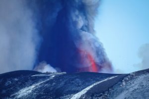
Explosive activity at the Southeast Crater. Activity has decreased, low ash emission is ongoing. The color code has changed back to ORANGE.
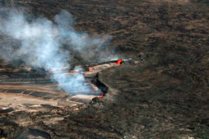
For the analyzed lava flow, preliminary measurements in the period from 8 to 12 February suggest that the lava effusion rate averaged between 2 and 3 cubic meters per second with the latest data of 3.2 m3/s estimated on 12 February at 17:00, while the cumulative volume reached a value of nearly one million cubic meters.
VOLCANO AVIATION OBSERVATION NOTICE (VONA)
Published: 14 February 2025
Volcano: Etna 211060
Current colour code: RED
Previous colour code: orange
Source: Etna Volcano Observatory
Notice number: 2025/0009/01E02
Volcano location: 3744N 01500E
Area: Italy
Summit altitude: 3,300 m

Volcanic Activity Summary:
Strong explosive activity is observed in the summit craters.
Volcanic cloud height:
VOLCANIC CLOUD HEIGHT IS NOT ESTIMABLE
Other volcanic cloud information: N/A
Remarks:
THE PHENOMENON IS OBSERVED BY INGV’S PERSONNEL ON THE FIELD AND BY VISIBLE AND THERMAL SURVEILLANCE CAMERAS
Next Notice:
A new VONA will be issued if conditions change significantly or color code changes.
Source : INGV.
Photo : Giuseppe Distefano / Marco Restivo / EtnaWalk via FB.
Indonesia , Merapi :
MOUNT MERAPI ACTIVITY REPORT, January 31 – February 6, 2025
OBSERVATION RESULT
Visual
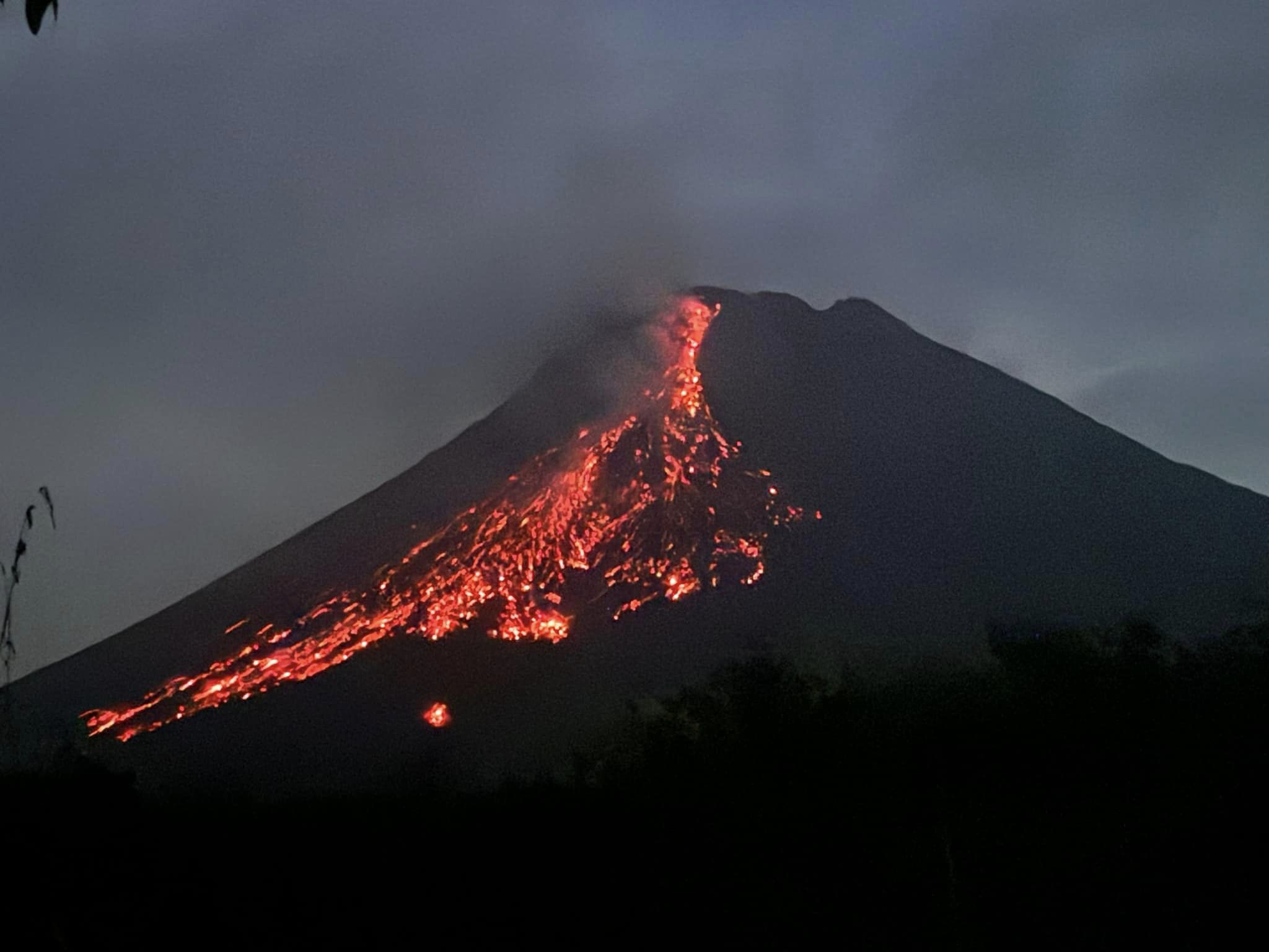
The weather around Mount Merapi is generally sunny in the morning and evening, while during the day it is hazy. White smoke, thin to thick, low to moderate pressure, with a height of 15 m was observed from Mount Merapi Badaban observation post on February 8, 2025 at 10:30 WIB. This week, lava avalanches were observed 59 times in the Southwest (upstream of Kali Bebeng) up to a maximum of 2,000 m, 12 times upstream of Kali Krasak up to a maximum of 1,800 m, and 24 times in the West (upstream of Kali Sat/Putih) up to a maximum of 1,800 m. The morphology of the Southwest dome was observed to have changed due to lava flow activity. For the central dome, no significant morphological changes were observed. According to the analysis of aerial photos dated January 4, 2025, the volume of the Southwest dome was measured at 3,505,900 m3. The central dome, on the other hand, measures 2,360,700 m3.
Seismicity:
This week, the seismicity of Mount Merapi recorded:
190 Multiphase (MP) earthquakes,
892 Avalanche (RF) earthquakes,
2 Low Frequency (LF) earthquakes,
13 Tectonic (TT) earthquakes.
The intensity of the earthquakes this week is still quite high.
Deformation
The deformation of Mount Merapi monitored using EDM and GPS this week showed no significant changes.
Rainfall and Lahars
This week, there was rain at the Kaliurang Mt. Merapi observation post (20mm for 112 min) and no reports of additional flows and lahars in the rivers that originate from Mount Merapi.
Conclusion
Based on the results of visual and instrumental observations, it is concluded that: The volcanic activity of Mount Merapi is still quite high in the form of effusive eruptive activity. The status of the activity is defined at the « SIAGA » level.
Source : BPPTKG
Photo : Maud Charlatte( 03/10 /2024).
Indonesia , Dukono :
An eruption of Mount Dukono occurred on Saturday, 15 February 2025 at 07:24 WIT with an observed ash column height of ±1200 m above the peak (±2287 m above sea level). The ash column was observed to be white to grey in colour with a thick intensity, oriented towards the northwest. At the time of writing, the eruption was still ongoing.

Seismicity observation:
217 explosion/eruption earthquakes with an amplitude of 6 to 34 mm and a duration of 35.85 to 83.68 seconds.
2 Distant tectonic earthquakes with an amplitude of 24 mm, and an earthquake duration of 70.53-75.68 seconds.
1 Continuous Tremor earthquake with an amplitude of 1-5 mm, dominant value 2 mm.
Recommendation
(1) People in the vicinity of Mount Dukono and visitors/tourists should not engage in activities, climb or approach the Malupang Warirang Crater within a radius of 4 km.
(2) Since volcanic ash eruptions occur periodically and the distribution of ash follows the direction and speed of the wind, so the area where the ash lands is not constant, residents around Mount Dukono are advised to always carry masks/nose and mouth covers to use when needed to avoid the threat of volcanic ash to the respiratory system.
Source et photo : Magma Indonésie .
Greece , Santorini :
A unique seismic sequence has been ongoing near Santorini, in the Cyclades island complex, in the southern Aegean Sea, since 24 January 2025. The activated area is a southwest/northeast-trending zone about 30 km long and about 18 km wide. This area is most likely the southern side of the rupture zone (Papadopoulos & Pavlides, 1992) of the very large tsunamigenic earthquake (Mw7.7; ISC-GEM 2023 catalogue) and its large aftershock (Mw6.9) of 9 July 1956. The maximum magnitude determined so far is ML5.2, Mw5.0 (5 February 2025, 19:09:39 GMT). The focal depths of the sequence do not exceed about 20 km. The country’s civil protection authorities have announced urgent protective countermeasures. It is estimated that more than 5,000 people have left the island of Santorini in recent days, reflecting the social significance of the ongoing seismicity.

Earthquake epicenters and their progressive migration from the South-West to the North-East. Large red circles illustrate the magnitude of ML≥4.
Seismicity and seismotectonics
The earthquake cluster is concentrated beyond the intra-caldera volcanic center of Kammeni and the extra-caldera submarine volcano Kolumbo. The earthquake epicenters have progressively moved from the South-West to the North-East (Fig. 1). During the last 4-5 days, the activity has stopped on the eastern side of the activated zone and the largest earthquakes (ML≥4, red color in Fig. 1) have been concentrated there. This process has been accompanied by an acceleration of the activity rate and a progressive increase in magnitudes
Source : Emsc-Csem.org
Lire l’article : http://A unique seismic cluster near Santorini, Greece, foreshadows a strong earthquake?