February 07 , 2025.
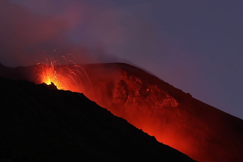
Italy , Stromboli :
Statement on Stromboli activity, 06 February 2025, 08:38 (07:38 UTC)
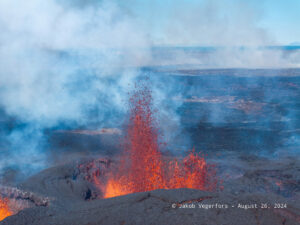
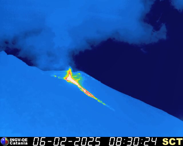
The National Institute of Geophysics and Volcanology, Etneo Observatory, reports that thanks to the analysis of surveillance camera images, effusive activity from the lava overflow from the North Crater area has been observed since 06:08 GMT. The activity is the consequence of an intensification of spattering that began in recent days. Currently, the lava flow front is located in the upper part of the Sciara del Fuoco.
At the same time, ordinary explosive activity continues in the areas of the North and Central-South craters.
From a seismic point of view, during the day the average amplitude of the volcanic tremor oscillated between medium and high values. At the moment, the amplitude of the tremor presents average values. No significant changes have been reported in the occurrence rate and amplitude of explosion earthquakes.
The deformation data from the GPS network (HF) and the TDF inclinometer station do not show significant variations.
Statement on the activity of Stromboli, 06 February 2025, 16:00 (15:00 UTC)
The National Institute of Geophysics and Volcanology, Etneo Observatory, reports that the images from the surveillance cameras show that the lava overflow fed by the North crater area, reported in the previous press release, has stopped and is cooling down. Ordinary explosive activity at varying rates persists in both crater zones and modest spatter activity in the North Crater zone.
During the last hours, the average amplitude of volcanic tremor remained within average values. No significant changes were reported in the occurrence rate and amplitude of explosion earthquakes.
Deformation monitoring signals (GPS and inclinometric network) do not show significant variations.
Further updates will be communicated shortly.
Source : INGV
Photos : INGV , Thomas Bretscher via Stromboli stati d’animo .
Alaska , Spurr :
ALASKA VOLCANO OBSERVATORY INFORMATION STATEMENT / U.S. Geological Survey
Thursday, February 6, 2025, 4:55 PM AKST (Friday, February 7, 2025, 01:55 UTC)
61°17’56 » N 152°15’14 » W,
Summit Elevation 11070 ft (3374 m)
Current Volcano Alert Level: ADVISORY
Current Aviation Color Code: YELLOW
Summary
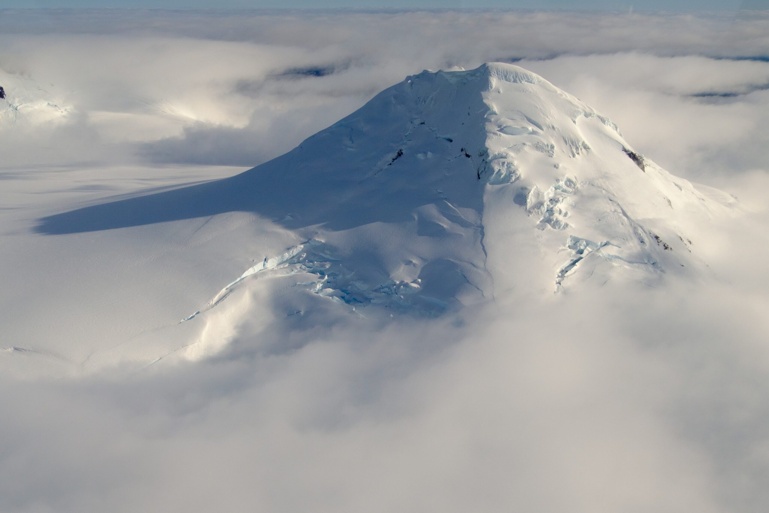
Volcanic unrest continues at Mount Spurr, an ice- and snow-covered volcano located on the west side of Cook Inlet approximately 75 miles (120 km) west of Anchorage. The most likely cause is new magma beneath the volcano.
The duration (10 months) and nature of the unrest suggest that an eruption is possible. The most likely site of an eruption is the Crater Peak vent, which erupted in 1992 and 1953. It is less likely that an eruption would occur from Spurr summit, which last erupted several thousand years ago. Past Crater Peak eruptions were often explosive, and far-traveled ash clouds and ashfall can be expected if an eruption occurs.
We expect to see additional seismic activity, gas emissions, and surface heating, as well as changes to surface deformation prior to an eruption, if one were to occur. Such stronger unrest may provide days to a few weeks of additional warning, but that is not certain.
AVO is undertaking repairs to the monitoring network this week to improve data return. The current data flow allows us to track activity and detect changes that would precede an eruption. An observation and gas measurement flight is scheduled for February 7.
Observations and background
An increase in the number of earthquakes underneath Mount Spurr was first observed in April 2024 and continues. The rate of earthquakes has increased from an average of 30 per week from April to early October to a rate of 125 per week from early October to now. AVO has located over 2700 earthquakes during the unrest episode thus far. The largest of these earthquakes is a magnitude 2.9 that occurred on January 2, 2025.
During the unrest episode, earthquakes have clustered at two depths: 0–6 miles (0–10 km) and 12–22 miles (20–35 km) beneath the volcano. Recently, a higher proportion of the earthquakes have occurred in the shallower zone. Shallow quakes are occurring underneath both vents of the volcano, Spurr summit and Crater Peak, though there has been a recent increase in the number of earthquakes under Crater Peak.
Starting at about the same time as the increase in earthquakes in April, we have detected steady surface deformation (“inflation”) using Global Navigation Satellite System (GNSS) stations on the flanks of the volcano. The total movement away from the volcano to date is about ~2.4 inches (~6 cm) at the closest GNSS station. Preliminary modeling of the inflation suggests a source around 2 to 3 miles (3 to 5 km) below sea level and about 2 miles (3 to 4 km) west of Mount Spurr’s summit. Satellite radar data confirm the GNSS-detected uplift. This inflation may be caused by new magma, fluids, or gases.
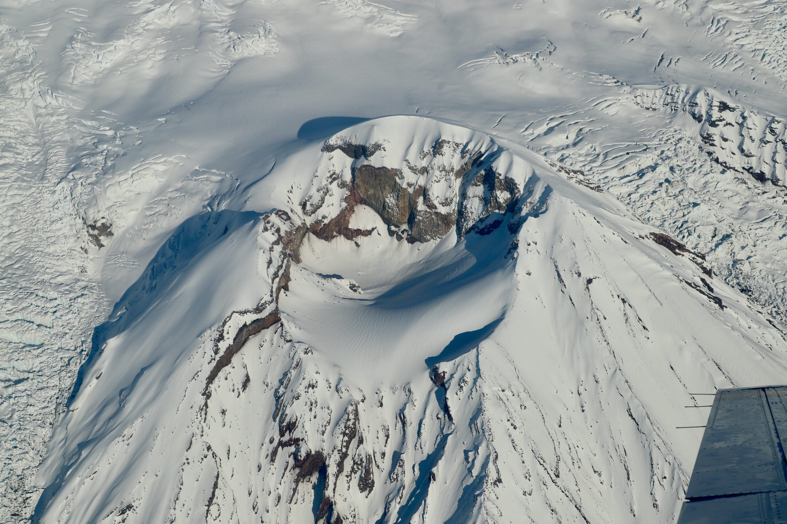
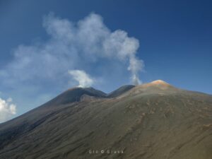
Crater Peak of Mount Spurr observed during the fall 2020 gas flight.
In early summer 2024, a small lake appeared in the crater at Spurr summit consistent with a modest increase in heat flow. The lake has grown slowly to an area of approximately 5 acres through small collapses and melting of ice inside the crater. The lake is partially covered by ice and remains blue-green in color. Active steaming from summit area fumaroles continues and has not changed over this current period of unrest and remains similar to observations from recent years. Unlike at the summit, we have seen no significant surface changes at Crater Peak.
Two gas-measurement flights, on June 23 and December 18, detected low levels of sulfur dioxide and carbon dioxide gas that are similar to background levels measured in previous years. An additional measurement is planned for February 7.
Mount Spurr is monitored by a local seismic network, GNSS ground deformation stations, infrasound sensors, and a webcam. Remote sensing data, including satellite imagery of surface changes and ash and gas emissions, regional infrasound sensors, and lightning data are also used to detect unrest and eruptions at the volcano. Winter weather can affect data transmission from our remote monitoring sites, and we continue to perform maintenance to mitigate these effects and ensure continual data flow.
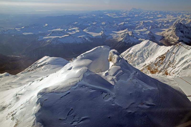
The only known historical eruptions from Mount Spurr occurred in 1953 and 1992 from the Crater Peak flank vent located 2 miles (3.5 km) south of the peak’s summit. These eruptions were brief, explosive, and produced columns of ash that rose up to 65,000 feet (20 km) above sea level and deposited minor ashfall in south-central Alaska (up to ¼ inch or 6 mm). The last known eruption from the summit of Mount Spurr was more than 5,000 years ago. In 2004, Mount Spurr experienced an episode of increased seismicity, surface uplift, and heating that melted a large hole in the summit ice cap and generated debris flows but no eruption occurred. Primary hazards during future eruptions include far-traveled ash clouds, ashfall, pyroclastic flows, and lahars or mudflows that could inundate drainages all sides of the volcano, but primarily on the south and east flanks.
AVO will continue to monitor the volcano closely. New data and observations may lead us to change our assessment. Any changes would be announced in a subsequent Information Release.
Source : AVO
Photos : Loewen, M. W. ( 2018 ) , Lyons, John ( 2020) , McGimsey, Game ( 2016) / Alaska Volcano Observatory / U.S. Geological Survey .
Indonesia , Gamalama :
Increased volcanic seismicity at Gamalama, North Maluku, on 5 February 2025.
Geographically, the summit of Mount Gamalama in the North Maluku is located at 0°48′ N and 127°19′ E with a height of 1,715 m above sea level. Gamalama is an active volcano with a history of recorded eruptions since 1538 with eruption intervals ranging from 1 to 50 years.
The seismicity of Mount Gamalama since January 2025 has been dominated by distant tectonic earthquakes, local tectonic earthquakes, and deep volcanic earthquakes (VA). Deep volcanic earthquake (VA) events are typically recorded at a rate of 1 to 2 events per day. The smoke from the crater is usually observed as white, thin or thick, with a height of 20 to 100 meters above the summit. The current activity level is at level II (Waspada) since March 10, 2015. The last eruption occurred on October 4, 2018, with 7 volcanic earthquakes recorded in the hour before the eruption. The height of the eruption column reached 250 meters from the summit.
The latest developments in Mount Gamalama’s activities up to 4 February 2024 at 24:00 WIT are as follows:
There has been an increase in deep volcanic earthquakes (DVAs) from 29 January to 4 February 2025. With the highest recording of DVAs on 1 February 2025, 10 DVAs were recorded with an amplitude of 6 to 26 mm. This increase in DVAs indicates an increase in pressure within the Gamalama body due to increased magmatic activity.

From January 29 to February 4, 2025, the seismicity that was recorded:
3 emission earthquakes,
3 Tornillo earthquakes,
36 deep volcanic earthquakes,
15 local tectonic earthquakes,
58 deep tectonic earthquakes.
The emission activity of the crater was observed with a white crater smoke, thin to thick with a height of 20 to 100 meters, weak to strong winds to the North, Northeast, Southeast, South and Northwest.
In general, the activity of Mount Gamalama from 1 January 2025 to 4 February 2024 at 24:00 WIT tends to fluctuate and increase, especially deep volcanic earthquakes since 29 January 2025, while for local tectonic earthquakes and distant tectonic earthquakes are related to regional tectonic activity around the Halmahera Islands.
Under the above conditions, and taking into account the characteristics of the precursors of the eruption of Mount Gamalama, the most likely potential hazard is a phreatic eruption with the current threat of hazard in the form of material thrown from the main crater hitting an area with a radius of 1.5 km from the eruption centre. Fine ash rain may occur, the distance and intensity depending on the wind direction and speed.
Based on the results of observations and analysis of visual and instrumental data, the volcanic activity of Mount Gamalama is still at level II (WASPADA).
Source : PVMBG
Photo : IST
Chile , Lascar :
Special Report on Volcanic Activity (REAV). Antofagasta Region, Láscar Volcano, February 6, 2025, 19:55 local time (Chilean continent)
The National Geology and Mining Service of Chile (Sernageomin) announces the following information, obtained through the monitoring equipment of the National Volcanic Monitoring Network (RNVV), processed and analyzed at the Southern Andean Volcanological Observatory (OVDAS):
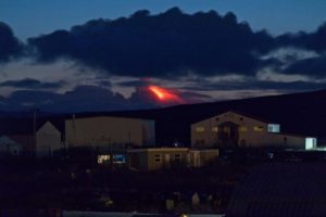
During the day, significant changes were observed in the monitoring parameters of the Láscar Volcano. The surveillance cameras installed near the volcano recorded an increase in whitish degassing and in the height of the columns, with values reaching almost 2 km above the crater level.
Although the presence of pyroclasts was not detected in the column, the MOUNTS satellite platform (www.mounts-project.com) reported one (1) anomaly of SO2, a gas originating from deep magma, with an estimated value of 188 tons of emitted mass, considered atypical compared to the available records from last year.
![]()
On the other hand, SENTINEL 2 L2A satellite images (www.copernicus.eu) indicate one (1) false-color radiation anomaly, located inside the active crater, suggesting an increase in temperature inside the active crater. Regarding seismic activity, no relevant changes associated with the reported activity have been recorded.
This history suggests a possible opening of the surface system, which could lead to the observation of incandescence and, possibly, to the occurrence of minor explosions with limited impact in the vicinity of the active crater.
Based on the assessment of the activity recorded during the indicated period, the technical alert for this volcanic system remains at green technical alert.
Source : Sernageomin
Photo : Sernageomin / Gabriel Orozco.
Colombia , Galeras :
San Juan de Pasto, February 4, 2025, 2:55 p.m. .
Following the monitoring of the activity of the Galeras volcano, the Colombian Geological Survey (SGC), an entity attached to the Ministry of Mines and Energy, reports that:
During the week of January 28 to February 3, 2025, volcanic activity remained low, similar to that recorded in the previous period. Compared to the previous week, the main variations in the monitored parameters were:
• A slight increase in the occurrence and released seismic energy was observed. The predominance of seismic activity related to rock fracturing processes within the volcano continued.
• The earthquakes related to rock fracture were concentrated, for the most part, near the volcanic cone, at very superficial levels, with depths less than 2.5 km from the summit (4,200 m above sea level). Some earthquakes were located scattered throughout the volcanic area, at maximum distances of 8 km and depths of up to 11 km from the summit. The maximum magnitude was 1.8.
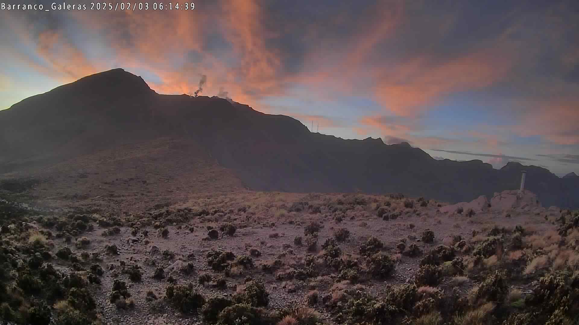
• Low gas emissions were recorded, mainly from the fumarole fields of Las Chavas, to the West; and El Paisita, to the North of the currently active cone, with white columns, of low height and variable dispersion due to the action of the winds.
• The other parameters of the volcanic monitoring showed stability.
Based on the above, the SGC recommends closely monitoring the evolution through the weekly bulletins and other information published through our official channels, as well as the instructions of the local and departmental authorities and the National Unit for Disaster Risk Management (UNGRD).
The volcanic activity remains in yellow alert status: active volcano with changes in the behavior of the base level of the monitored parameters and other manifestations.
Source et photo : Ingeominas .