January 25 , 2025 .
Hawaii , Kilauea :
Friday, January 24, 2025, 9:59 AM HST (Friday, January 24, 2025, 19:59 UTC)
19°25’16 » N 155°17’13 » W,
Summit Elevation 4091 ft (1247 m)
Current Volcano Alert Level: WATCH
Current Aviation Color Code: ORANGE
Activity Summary:
Summit eruption has been paused since 4:30 a.m. HST January 23. Resumption of activity possible beginning in 4-5 days at current inflation rates.
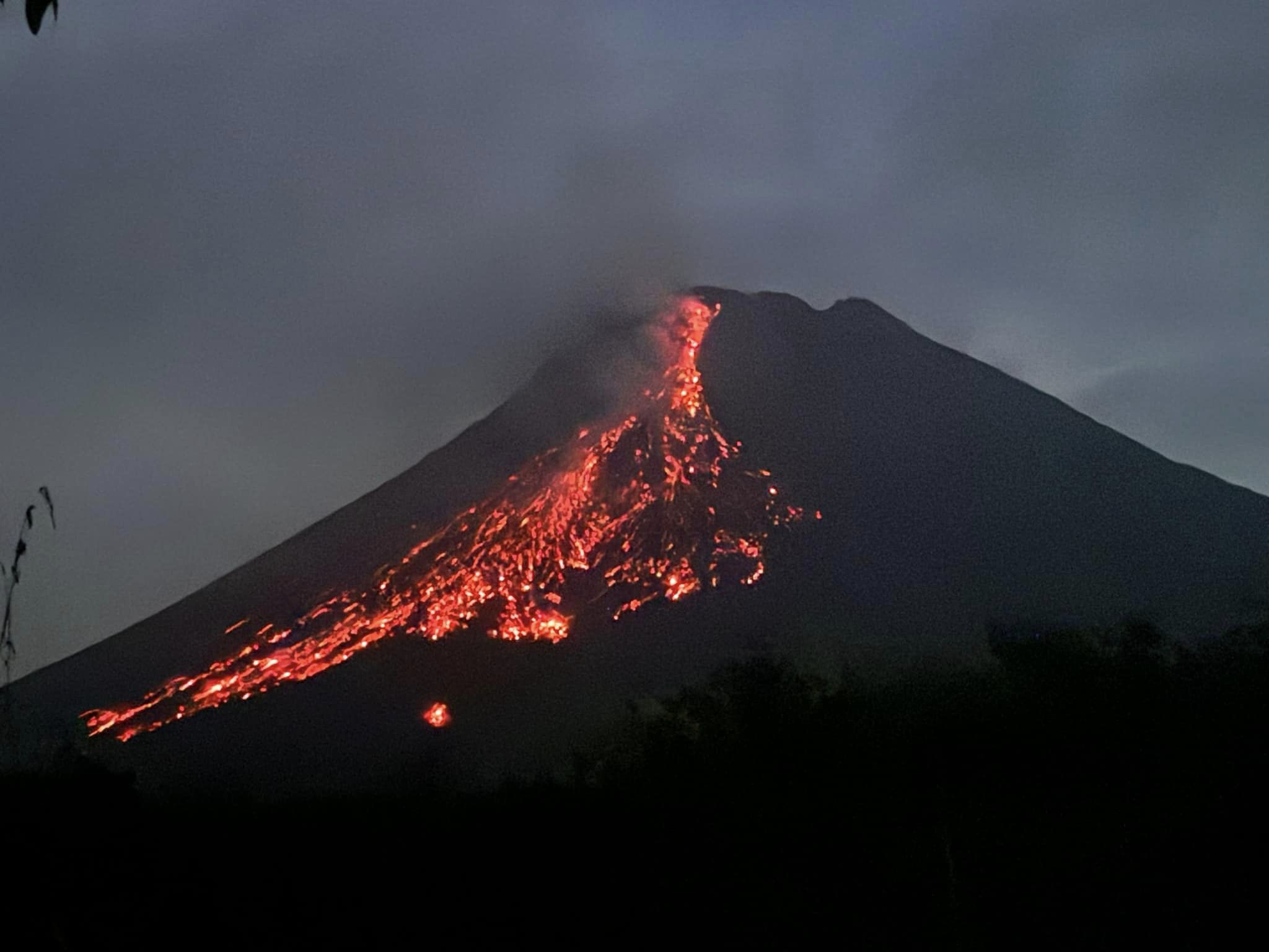
Kīlauea’s current eruption in Halemaʻumaʻu crater within Kaluapele (the summit caldera) began on December 23, 2024. The eruption has included five episodes of lava fountaining separated by pauses in activity. The fifth episode ended on January 23, 2025, after about 14 hours of eruptive activity from the north vent. Seismicity is low with less than 10 small earthquakes beneath the summit and rift zones of Kīlauea. Summit inflation has slowed significantly over the past day.

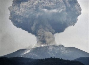
The north vent that was erupting during episode five of the recent Kīlauea summit eruption shows a small slab of lava that spattered weakly during the morning of February 24, 2025.
Current hazards include volcanic gas emissions and windblown volcanic glass (Pele’s Hair) that may impact Hawai’i Volcanoes National Park and nearby communities. No unusual activity has been noted along Kīlauea’s East Rift Zone or Southwest Rift Zone.
Summit Observations:
The fifth episode of this eruption began around 3:00 p.m. on January 22 and ended at 4:30 .a.m on January 23. Episode 5 fountains erupting from the north vent fed a lava flow that spread over about one half of the floor of Halemaʻumaʻu crater. Spots of orange glow can be seen at night on the crater floor as the lava continues to cool. Strong glow from the north vent indicates that magma remains close to the surface.
Seismicity remains low in the summit region. Two earthquakes were detected over the past day with magnitudes of 0 or less. Summit inflation continues at a reduced rate of less than 1 microradian per day. The Uēkahuna tiltmeter (UWD) recorded under 2 microradians of inflation over the past day since the end of episode 5.
Volcanic gas emissions remain elevated. A sulfur dioxide (SO2) emission rate of approximately 10,000 tonnes per day was measured on January 22 at the start of episode 5. Emissions rates have decreased since episode 5 ended and are currently estimated to be near 1,000 tonnes per day, well above background levels.
Rift Zone Observations:
Rates of seismicity and ground deformation remain very low in the East Rift Zone and Southwest Rift Zone with less than 10 earthquakes in the past 24 hours.
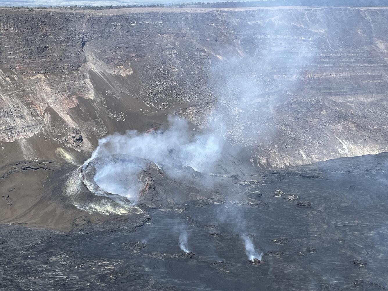
Kīlauea’S 2024-2025 eruption resumed around 3 pm HST on January 22, 2025, and ended around 4:30 am HST on January 23, 2025. USGS Hawaiian Volcano Observatory field crews observed the eruptive vents around 9 am on January 23 after the eruption had paused again. The south cone (on the left) is 40 m (131 feet) tall and the north cone (on the right) is about 38 m (125 feet tall).
Analysis:
The current eruption is marked by episodic fountaining not seen in any of the other Halemaʻumaʻu eruptions since 2020. Episodic fountains and lava flows have erupted from two vents that we refer to as the north vent and south vent. There have been five fountaining episodes to date lasting from a few hours to over a week. Each fountaining episode has been accompanied by strong deflation of the summit region. Pauses or periods of repose between the fountaining episodes have been marked by an immediate change from deflation to inflation as the magma chamber recharges and repressurizes.
The prior five episodes all began after the Uēkahuna tiltmeter (UWD) recorded between 6 and 12 microradians of inflationary tilt. UWD has recorded about 1.7 microradians since episode 5 ended, but the current rate has slowed to about 1 microradian per day. If this slower rate of recovery continues, another episode isnʻt likely to begin for at least 4-5 more days (January 28-29), but more time is needed to accurately estimate a probability window. The probable window of time for the start of the next episode is based upon behavior prior to previous episodes and could be longer if the inflation rate slows or more pressure is required to initiate the next eruptive episode.
Source : HVO
Photos : USGS / J. Barnett , USGS / K. Lynn.
Indonesia , Merapi :
MOUNT MERAPI ACTIVITY REPORT, January 17-23, 2025
OBSERVATION RESULT
Visual
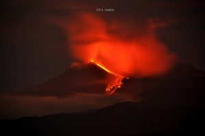
The weather around Mount Merapi is generally sunny in the morning and evening, while during the day it is hazy. White smoke, thin to thick, low to moderate pressure and 50 m high was observed from the Mount Merapi observation post in Kaliurang on January 22, 2025 at 05:48 WIB. This week, lava avalanches were observed 28 times in the southwest (upstream of the Bebeng River) up to a maximum of 2,000 m, 19 times upstream of the Krasak River up to a maximum of 1,700 m, and 19 times in the west (upstream of the Sat/Putih River) up to a maximum of 1,600 m. The morphology of the Southwest dome was observed to have changed due to lava flow activity. For the central dome, no significant morphological changes were observed. According to the analysis of aerial photos dated January 4, 2025, the volume of the Southwest dome was measured at 3,505,900 m3. The central dome, on the other hand, measures 2,360,700 m3.
Seismicity:
This week, the seismicity of Mount Merapi recorded:
4 shallow volcanic earthquakes (VTB),
368 multiphase earthquakes (MP),
723 avalanche earthquakes (RF),
7 Tectonic earthquakes (TT).
The intensity of earthquakes this week is still quite high
Deformation
The deformation of Mount Merapi monitored using EDM and GPS this week showed no significant changes.
Rainfall and Lahars
This week, it rained at Mount Merapi observation post with the highest rainfall intensity of 45 mm/hour for 45 minutes at Kaliurang post on 17 January 2025. There were no reports of additional discharge and lahars in the rivers that originate from Mount Merapi.
Conclusion
Based on the results of visual and instrumental observations, it is concluded that:
The volcanic activity of Mount Merapi is still quite high in the form of effusive eruptions. The activity status is defined at the « SIAGA » level.
Source : BPPTKG
Photo : Maud Charlatte( 03/10 /2024)
Kamchatka , Sheveluch :
VOLCANO OBSERVATORY NOTICE FOR AVIATION (VONA)
Issued: January 25 , 2025
Volcano: Sheveluch (CAVW #300270)
Current aviation colour code: ORANGE
Previous aviation colour code: orange
Source: KVERT
Notice Number: 2025-10
Volcano Location: N 56 deg 38 min E 161 deg 18 min
Area: Kamchatka, Russia
Summit Elevation: 3283 m (10768.24 ft), the dome elevation ~2500 m (8200 ft)
Volcanic Activity Summary:
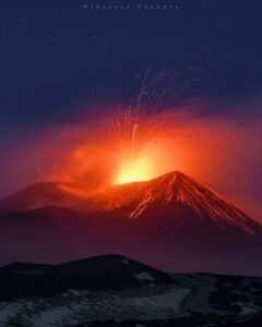
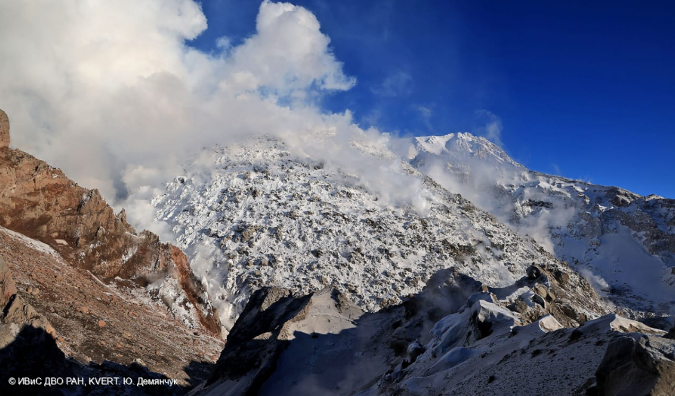
Video and satellite data by KVERT shows a strong wind lifts ash from the southern slopes of Sheveluch volcano, and a plume of resuspended ash is extending about 70 km to the east-south-east of the volcano.
An extrusive-effusive eruption of the Sheveluch volcano continues. The danger of ash explosions up to 10 km (32,800 ft) a.s.l. remains. Ongoing activity could affect international and low-flying aircraft.
Volcanic cloud height:
2500-3000 m (8200-9840 ft) AMSL Time and method of ash plume/cloud height determination: 20250125/0200Z – Himawari-9 14m15
Other volcanic cloud information:
Distance of ash plume/cloud of the volcano: 70 km (43 mi)
Direction of drift of ash plume/cloud of the volcano: ESE / azimuth 105 deg
Time and method of ash plume/cloud determination: 20250125/0230Z – Visual data
Source : KVERT
Photo : Yu. Demyanchuk. IVS FEB RAS, KVERT ( 01/2025)
Indonesia , Ibu :
An eruption of Mount Ibu occurred on Saturday, 25 January 2025 at 09:02 WIT with an observed ash column height of ± 1200 m above the peak (± 2525 m above sea level). The ash column was observed to be grey in colour with a thick intensity, oriented towards the South-West. This eruption was recorded on a seismograph with a maximum amplitude of 28 mm and a duration of 106 seconds.
The volcano continues its eruption with explosions at 08:53, 08:21, 07:23, 07:08, 05:04, etc…

VOLCANO OBSERVATORY NOTICE FOR AVIATION – VONA
Issued : January 25 , 2025
Volcano : Ibu (268030)
Current Aviation Colour Code : ORANGE
Previous Aviation Colour Code : orange
Source : Ibu Volcano Observatory
Notice Number : 2025IBU173
Volcano Location : N 01 deg 29 min 17 sec E 127 deg 37 min 48 sec
Area : North Maluku, Indonesia
Summit Elevation : 4240 FT (1325 M)
Volcanic Activity Summary :
Eruption with volcanic ash cloud at 00h02 UTC (09h02 local).
Volcanic Cloud Height :
Best estimate of ash-cloud top is around 8080 FT (2525 M) above sea level or 3840 FT (1200 M) above summit. May be higher than what can be observed clearly. Source of height data: ground observer.
Other Volcanic Cloud Information :
Ash cloud moving to southwest. Volcanic ash is observed to be gray. The intensity of volcanic ash is observed to be thick.
Remarks :
Eruption recorded on seismogram with maximum amplitude 28 mm and maximum duration 106 second.
Source et photo : Magma Indonésie .
Colombia , Chiles / Cerro Negro :
San Juan de Pasto, January 21, 2025, 4:20 p.m. .
Following the monitoring of the activity of the Chiles and Cerro Negro volcanoes, the Colombian Geological Survey (SGC), an entity attached to the Ministry of Mines and Energy, reports that:
During the week of January 14 to 20, 2025, volcanic activity showed stable behavior. Compared to the previous week, the main variations in the monitored parameters were:
• For this period, both the occurrence and the released seismic energy showed significant increases, compared to the values reported in recent months. The predominance of seismicity related to rock fracture within the volcanic edifice continued, in parallel with the significant recording of earthquakes associated with the movement of fluids in the volcanic system.
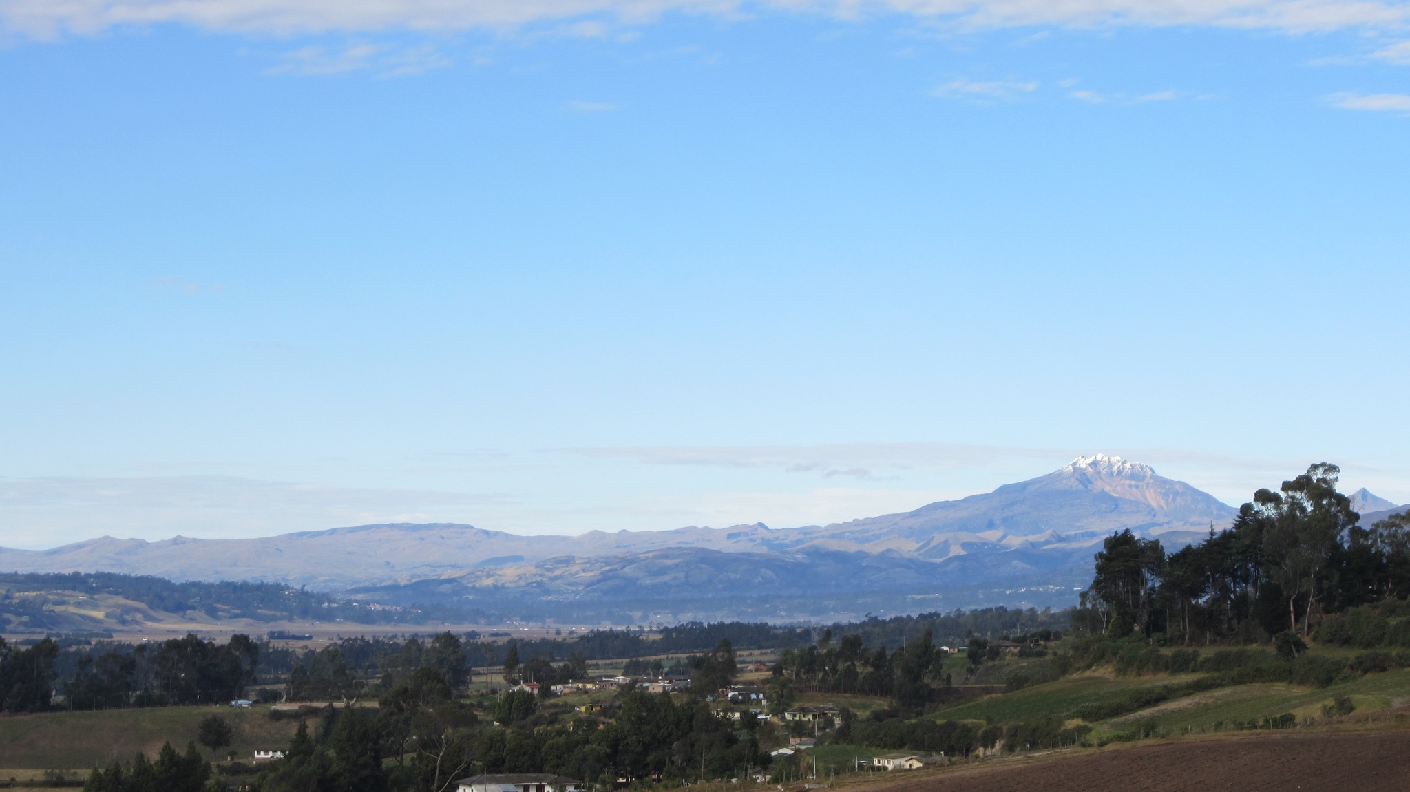
• Most of the seismic activity was located in the area known as the Chiles Volcano Collapse Zone, extending from its summit, approximately 2 km to the north and at a depth of between 2 and 6 km, relative to the summit of the volcano (4700 m). Some other events were located in the vicinity of these two volcanoes and some nearby in the area of the Cerro Negro volcano at surface levels. The maximum magnitude of this type of event was 1.6.
• Instruments that record crustal deformation and remote satellite sensors continue to show changes related to an inflationary process in this volcanic area.
Based on the above, the SGC recommends closely monitoring the evolution through the weekly bulletins and other information published through our official channels, as well as the instructions of local and departmental authorities and the National Disaster Risk Management Unit (UNGRD).
Volcanic activity remains in yellow alert status: active volcano with changes in the behavior of the base level of monitored parameters and other manifestations.
Source et photo : SGC