January 10 , 2025.
Indonesia , Ibu :
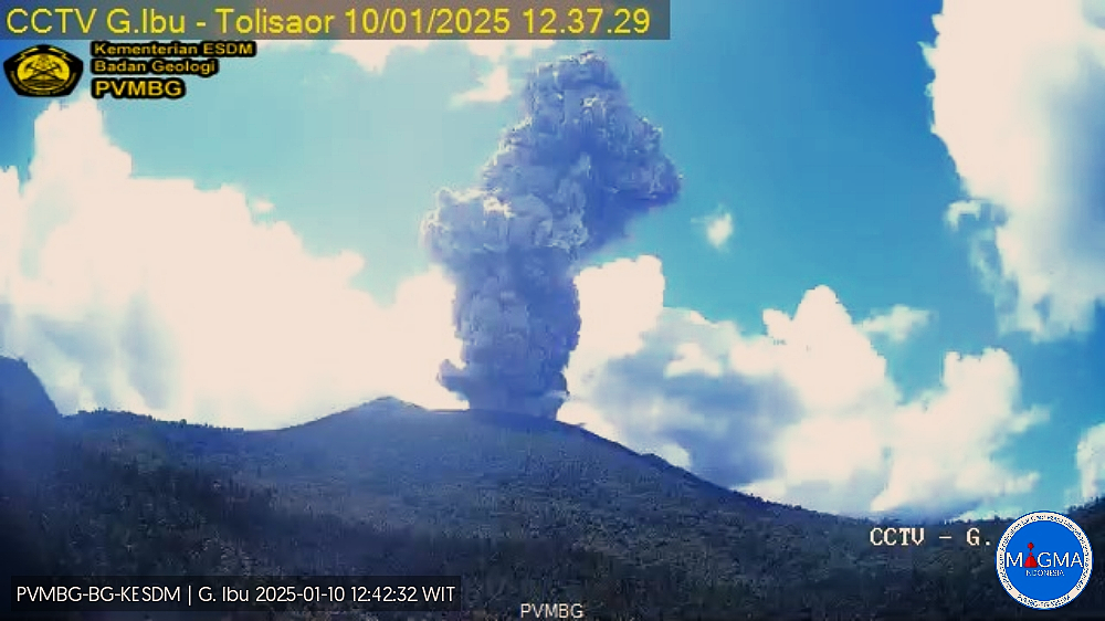
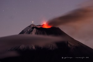
An eruption of Mount Ibu occurred on Friday, 10 January 2025, at 12:35 WIT with an observed ash column height of ± 3000 m above the peak (± 4325 m above sea level). The ash column was observed to be grey in colour with a thick intensity, oriented towards the West. This eruption was recorded on a seismograph with a maximum amplitude of 28 mm and a duration of 145 seconds.
VOLCANO OBSERVATORY NOTICE FOR AVIATION – VONA
Issued : January 10 , 2025
Volcano : Ibu (268030)
Current Aviation Colour Code : ORANGE
Previous Aviation Colour Code : orange
Source : Ibu Volcano Observatory
Notice Number : 2025IBU037
Volcano Location : N 01 deg 29 min 17 sec E 127 deg 37 min 48 sec
Area : North Maluku, Indonesia
Summit Elevation : 4240 FT (1325 M)
Volcanic Activity Summary :
Eruption with volcanic ash cloud at 03h35 UTC (12h35 local).
Volcanic Cloud Height :
Best estimate of ash-cloud top is around 13840 FT (4325 M) above sea level or 9600 FT (3000 M) above summit. May be higher than what can be observed clearly. Source of height data: ground observer.
Other Volcanic Cloud Information :
Ash cloud moving to west. Volcanic ash is observed to be gray. The intensity of volcanic ash is observed to be thick.
Remarks :
Eruption recorded on seismogram with maximum amplitude 28 mm and maximum duration 145 second.
Source et photo : Magma Indonésie .
Iceland , Grjótárvatn :
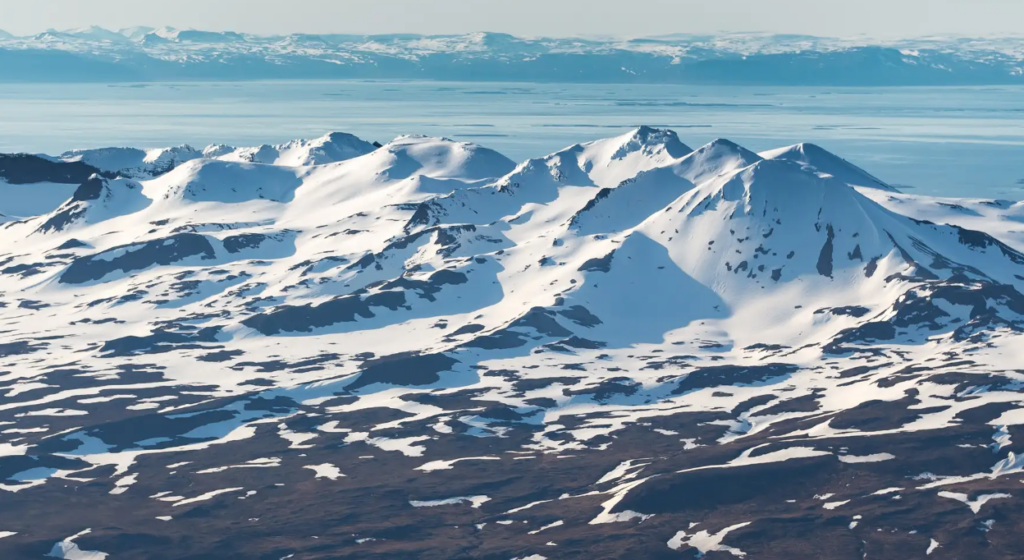
Magmatic intrusion at considerable depth beneath Grjótárvatn likely . Continued seismic activity in the area . Update 9. January 12:30 UTC
A tremor episode on Thursday, January 2nd
Ongoing earthquake activity characterized by deep earthquakes
No signs of deformation from GNSS station
A deep magma intrusion is likely the cause of the earthquakes
No indication of magma getting shallower
Monitoring level in Ljósufjöll has been elevated
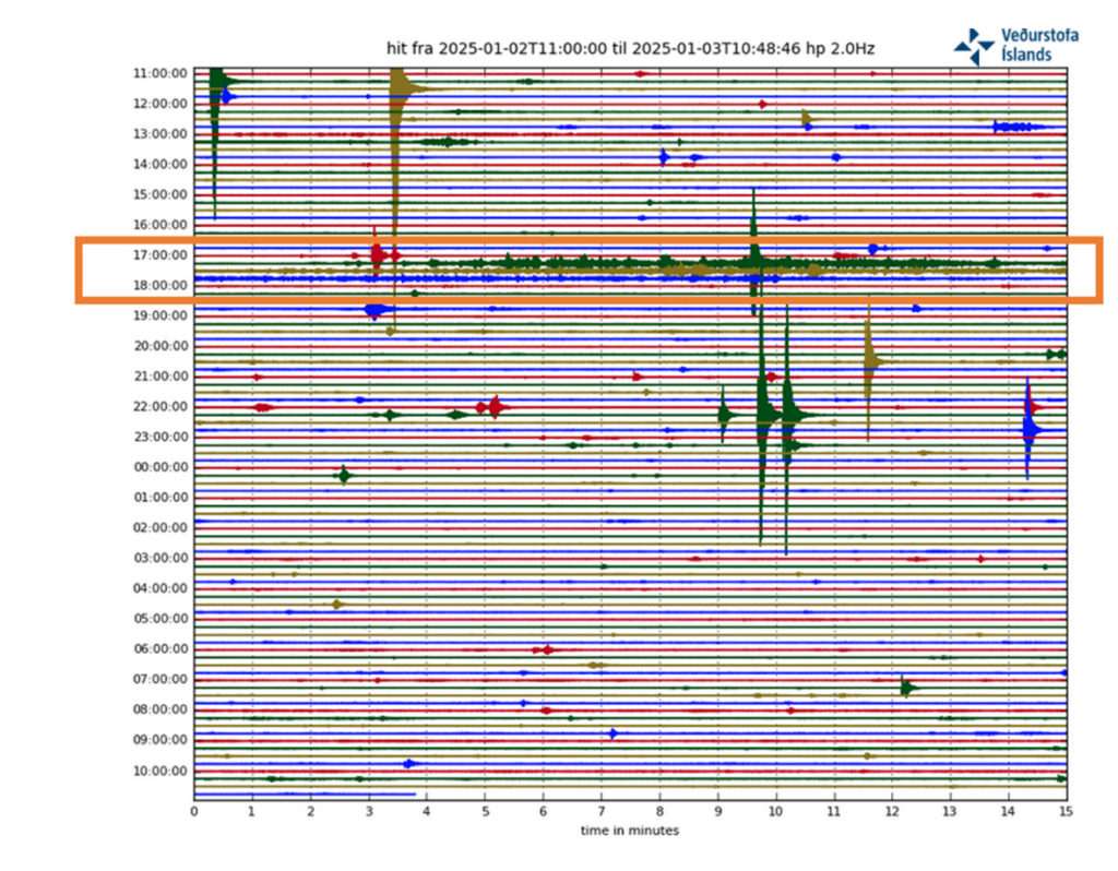
On Thursday, January 2nd, a tremor event was measured between 5:00 PM and 6:00 PM with its origin at Grjótárvatn. The tremor, lasting about 40 minutes, consisted of a series of continuous small earthquakes, most of which were too small to be located properly. Only two earthquakes within the tremor signal were located, they originated at a depth of approximately 15 km, with magnitudes of M1.5 and 1.8. A total of about 20 earthquakes were recorded that day, all at depths of 15–20 km and magnitudes ranging from M0.1–2.0.
Continuous tremor recorded at the new seismic station in Hítardalur between 5:00 PM and 6:00 PM on Thursday, January 2 (orange box). Individual earthquakes are visible before and after the tremor.
Earthquakes at these depths are unusual in Iceland. However, there are some examples, such as within the volcanic systems of Eyjafjallajökull in 1996, at Upptyppingar in 2007, as well as east of Bárðarbunga caldera where deep earthquakes are observed regularly.
In such volcanic settings, the mechanism causing the deep seismicity and associated micro earthquakes is the increased pressure in the crust due to magmatic intrusion. That causes sudden deformation which breaks the crust.
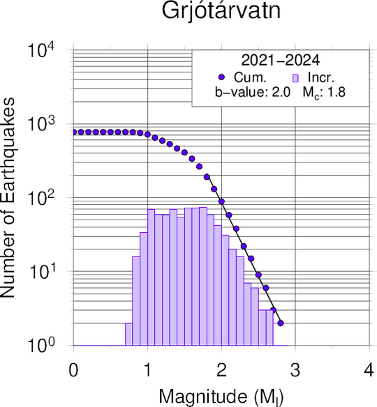
Yesterday morning (08.01), a monthly meeting was held at the IMO to review recent activity in volcanic systems across the country. The increased seismic activity near Grjótárvatn was reviewed and possible explanations discussed. Additional analysis was recently performed on the seismic data for the period 2021-2024 near Grjótárvatn. The results show that this seismic activity is characterized by a high b-value (~2), like what was observed in the deep seismic swarm at Upptyppingar in 2007–2008. High b-values are often associated with earthquakes in volcanic regions, indicating an unusually high proportion of small earthquakes
Gutenberg-Richter distribution illustrating the relationship between earthquake magnitude and frequency at Grjótárvatn during 2021–2024. The slope indicates a b-value of 2.
The analysis of satellite data from the period 2019 to summer 2024 does not show measurable deformation on the surface and InSAR observations are currently not usable in this area due to snow cover.
However, in early November last year, a GNSS station was installed in Hítardalur, approximately 4km NW of Grjótárvatn. Since then, no surface deformation has been measured, but this does not exclude the involvement of magma at depth. If magma is accumulating at deep levels (> 16 km), geodetic modelling indicates that deformation is not likely to be detected at the surface until the volume of intruded magma is quite large.
In addition to the depth of the earthquakes and their b-value, the duration of the activity along with the recent tremor pulses and the analogy with other volcanic systems indicate that the most likely explanation of this seismicity is a magmatic intrusion at depth. However, monitoring data currently available show no indications that magma is moving toward the surface.
As long as the seismic activity continues at similar depths, more earthquakes of around magnitude 3 can be expected, but it is unlikely that earthquakes much larger than magnitude 4 will occur at this depth.
Considering the increased level of activity and a likely deep magma intrusion, the Icelandic Meteorological Office (IMO) has raised the monitoring level for Ljósufjöll and work is underway to develop an enhanced monitoring plan for the area.
Source : IMO
Photos : IMO , RÚV – Einar Rafnsson
Indonesia , Iya :
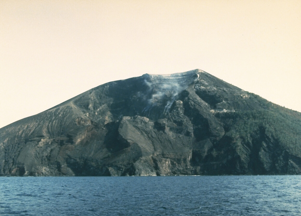
Decrease in the activity level of G. Iya, from activity level III (SIAGA) to level II (WASPADA).
Results of the assessment of the activity of G. Iya, for the period from 1 to 7 January 2025:
Visual monitoring
The volcano is clearly visible until it is covered by fog. The smoke observed from the main crater is white and gray, of fine to thick intensity, at approximately 10 to 200 meters height from the summit. The weather is sunny to rainy, with light to strong winds.
Instrumental observation
Earthquakes recorded during the period from 1 to 7 January 2025:
1 shallow volcanic earthquake,
52 deep volcanic earthquakes,
31 local tectonic earthquakes,
26 distant tectonic earthquakes
Continuous tremors of amplitude 0.1-1 mm, dominant value 0.9 mm.
Assessment
The results of visual monitoring of the smoke from the crater of Mount Iya from November 5, 2024 to January 7, 2025 showed that the smoke was mostly white with low pressure, the maximum height of the smoke was observed at 500 meters above the crater summit.
The results of earthquake monitoring from November 5, 2024 to January 7, 2025 still show deep earthquakes which indicate that there is still a magma supply, in addition, surface seismic activity in the form of continuous tremors still exists, but with a decreasing amplitude compared to the previous period.
The eruption features of Mount Iya generally occur in the main crater through magmatic eruptions that produce volcanic ash, hot rock ejections and lava flows. Fissures are developing around the active crater, indicating a weak zone within the volcano, which could potentially cause a major landslide towards the sea, if Mount Iya experiences a very large (catastrophic) eruption.
The current volcanic seismic activity tends to decrease, however, it is necessary to remain vigilant in case a large magnitude tectonic earthquake occurs around Mount Iya that could affect volcanic activity.
Conclusion
Based on visual and instrumental observations, the activity status of Mount Iya has been downgraded from Level III (SIAGA) to Level II (WASPADA), effective January 8, 2025 at 18:00 WITA.
Source : PVMBG.
Photo : Ruska Hadian, 1985 (Volcanological Survey of Indonesia).
Hawaii , Kilauea :
Thursday, January 9, 2025, 7:30 AM HST (Thursday, January 9, 2025, 17:30 UTC)
19°25’16 » N 155°17’13 » W,
Summit Elevation 4091 ft (1247 m)
Current Volcano Alert Level: WATCH
Current Aviation Color Code: ORANGE
Activity Summary:
The summit eruption at Kīlauea volcano that began on Monday, December 23 has been paused since 8:40 pm on Friday, January 3. Glow persists from the presently inactive eruptive vents on the southwest side of Kaluapele, the volcano’s summit caldera. No unusual activity has been noted along Kīlauea’s East Rift Zone or Southwest Rift Zone.
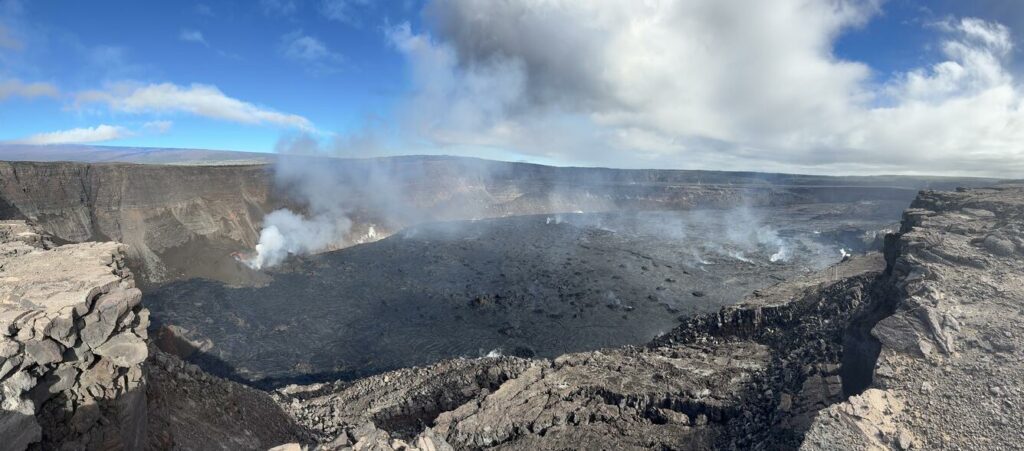
Looking out across Kaluapele, Kīlauea summit caldera, from the south rim, small islands of solidified crust dot the area of the lava pond that was fed from the lava fountains during the most recent eruption from December 23, 2024, to January 3, 2025.
Summit Instrumental Observations:
Seismicity in the summit region remains low, with only 1 small earthquake (below M2.0) detected in the past 24 hours. Seismic tremor remains at background levels, indicating little to no activity at the eruptive vents. Summit tiltmeters reversed from deflationary tilt to inflationary tilt around the same time that the single remaining lava fountain shut down on Friday, January 3; this inflationary tilt continues, but at a relatively low rate. The most recently measured sulfur dioxide (SO2) emission rate was approximately 30,000 tonnes per day on Thursday, January 2, during vigorous lava fountaining. Emissions of SO2 remain elevated above background levels, but the present rate is likely much lower due to the ongoing pause, and the resulting hazards will be affected by wind conditions (see Hazards section below).
Rift Zone Observations:
Seismicity remains low in both the East Rift Zone and Southwest Rift Zone, with counts of shallow earthquakes at background levels. The ESC tiltmeter in the upper part of the East Rift Zone was tracking deflation in association with the summit eruption, but its tilt trend has flattened during the ongoing pause. Deformation rates remain low in the middle and lower East Rift Zone and in the Southwest Rift Zone, as recorded by GPS instruments and tiltmeters.
Source : HVO
Photo : USGS / M. Patrick.
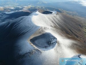
Colombia , Puracé – Chaîne volcanique Los Coconucos :
Popayan, January 7, 2025, 2:00 p.m. .
Following the monitoring of the activity of the Puracé volcano – Los Coconucos volcanic chain, the Colombian Geological Survey (SGC), an entity attached to the Ministry of Mines and Energy, reports that:
During the week of December 31, 2024 to January 6, 2025, seismic activity recorded an increase in the number of events compared to the previous week, mainly those related to the transit of fluids inside the volcano. This seismicity presented low energy contributions. The events related to the movement of fluids were located mainly under the building of the Puracé volcano, at depths of less than 3 km, while the seismicity of the fractures was concentrated under the Puracé and Piocollo craters, with depths of up to 5 km.
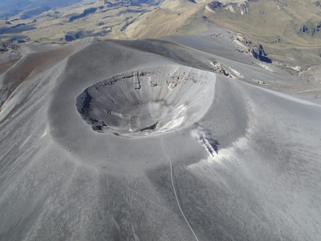
Regarding deformation, electromagnetic fields and acoustic sensors, no significant variations were observed. Regarding the monitoring of volcanic gases, SO2 emissions were recorded throughout the week, at levels considered low. Likewise, in the images captured by visible and infrared spectrum webcams, it was observed that high degassing in the fumarole fields was maintained and thermal anomalies were detected in the same sector.
Based on the above, the SGC recommends closely monitoring the evolution of volcanic activity through weekly bulletins and other information published on official channels, as well as complying with the instructions of local, departmental authorities and the National Disaster Risk Management Unit (UNGRD).
The alert status for volcanic activity remains at yellow alert status: active volcano with changes in the behavior of the base level of the monitored parameters and other manifestations.
Source et photo : SGC

