Ecuador , Sangay :
THURSDAY, OCTOBER 24, 2024
Since the morning of today, October 24, 2024, an increase in the activity of the Sangay volcano has been recorded, characterized by a continuous emission of gas and ash that reaches a height of 1 km above the level of the crater that heads towards the south and southeast of the volcano. At the moment, this emission is maintained, so a slight ash fall could be recorded in the city of Macas, province of Morona Santiago. This phenomenon is recurrent during the current eruptive period that began in May 2019. The IG-EPN continues to monitor the event and will report in a timely manner if changes in the monitoring signals are detected.
FRIDAY, OCTOBER 25, 2024
Today, Friday, October 25, since the early hours of the morning, thanks to surveillance cameras and satellite images (GOES-16), an emission of gas and ash has been continuously observed that reaches 1,200 meters above the crater and is heading southwest of the volcano. At the moment, this emission is maintained, which is why a slight ash fall could be recorded in localities located south of the province of Chimborazo, such as the canton of Alausí. This phenomenon is recurrent during the current eruptive period that began in May 2019. The IG-EPN continues to monitor the event and will report in a timely manner if changes in the monitoring signals are detected.
Source : Instituto Geofísico EPN – Ecuador
Photo :Volcan Sangay FB
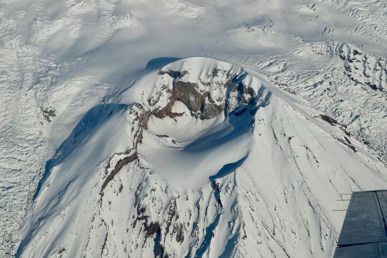
Alaska , Spurr :
61°17’56 » N 152°15’14 » W,
Summit Elevation 11070 ft (3374 m)
Current Volcano Alert Level: ADVISORY
Current Aviation Color Code: YELLOW
There have been no significant changes in unrest at Mount Spurr over the past week. Seismicity is elevated slightly from last week with numerous small earthquakes detected daily or about 80 earthquakes over the past week. No unusual activity was observed in mostly clear satellite or web camera data. On October 24, an AVO field crew visited Mount Spurr to perform pre-winter work to harden the network and ensure all systems are operational. They also flew over the summit crater and Crater Peak, a vent 3.5 km (2 mi) south of the summit, to make observations. They saw vigorous steam from the fumaroles in the summit crater. The Crater Peak vent was snow-covered.
AVO is closely monitoring Mount Spurr for signs of an impending eruption. We would expect changes in the earthquakes, ground deformation, summit lake, and fumaroles if magma began to move closer to the surface. Thus, if an eruption were to occur, it would be preceded by additional signals that would allow advance warning.
Mount Spurr volcano is an ice- and snow-covered stratovolcano located on the west side of Cook Inlet approximately 120 km (75 mi) west of Anchorage. The only known historical eruptions occurred in 1953 and 1992 from the Crater Peak flank vent located 3.5 km (2 mi) south of the summit of Mount Spurr. These eruptions were brief, explosive, and produced columns of ash that rose up to 20 km (65,000 ft) above sea level and deposited several mm of ash in south-central Alaska, including approximately 6 mm of ash on Anchorage in 1953. The last known eruption from the summit of Mount Spurr was more than 5,000 years ago. Primary hazards during future eruptions include far-traveled ash clouds, ash fall, pyroclastic flows, and lahars or mudflows that could inundate drainages all sides of the volcano, but primarily on the south and east flanks.
Source : AVO
Photo : Lyons, John / Alaska Volcano Observatory / U.S. Geological Survey . (10/ 2020).
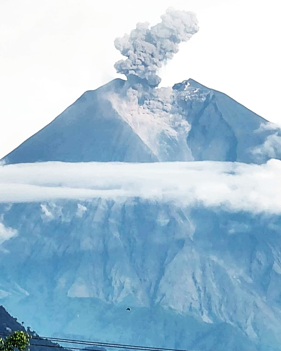
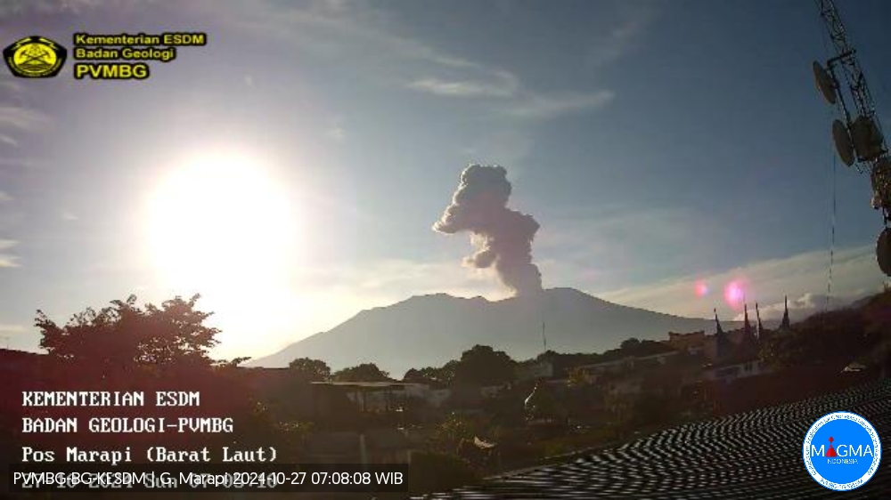
Indonesia , Marapi :
An eruption of Mount Marapi occurred on Sunday, October 27, 2024 at 07:00 WIB with the height of the ash column observed at ± 1000 m above the summit (± 3891 m above sea level). The ash column was observed to be gray in color with a thick intensity oriented towards the northwest. At the time of writing this report, the eruption was still ongoing.
VOLCANO OBSERVATORY NOTICE FOR AVIATION – VONA
Issued : October 27 , 2024
Volcano : Marapi (261140)
Current Aviation Colour Code : ORANGE
Previous Aviation Colour Code : orange
Source : Marapi Volcano Observatory
Notice Number : 2024MAR082
Volcano Location : S 0 deg 22 min 52 sec E 100 deg 28 min 23 sec
Area : West Sumatra, Indonesia
Summit Elevation : 9251 FT (2891 M)
Volcanic Activity Summary :
Eruption with volcanic ash cloud at 00h00 UTC (07h00 local).
Volcanic Cloud Height :
Best estimate of ash-cloud top is around 12451 FT (3891 M) above sea level or 3200 FT (1000 M) above summit. May be higher than what can be observed clearly. Source of height data: ground observer.
Other Volcanic Cloud Information :
Ash cloud moving to northwest. Volcanic ash is observed to be gray. The intensity of volcanic ash is observed to be thick.
Remarks :
Eruption and ash emission is continuing. Eruption recorded on seismogram with maximum amplitude 27 mm.
Source et photo : Magma Indonésie.
Colombia , Cumbal :
San Juan de Pasto, October 22, 2024, 3:20 p.m.
From the monitoring of the activity of the Cumbal Volcanic Complex (CVC), the Colombian Geological Survey (SGC), an entity attached to the Ministry of Mines and Energy, reports that:
During the week of October 15 to 21, 2024, the activity of the Cumbal Volcanic Complex (CVC) maintained a stable behavior. Compared to the previous week, the main variations in the monitored parameters were:
● Within the fluctuating behavior of seismicity, characteristic of this volcanic complex, an increase in seismic occurrence was recorded, maintaining similar levels of released energy.
● The predominance of the occurrence and energy of seismicity associated with the fracture of rocks within the volcanic complex was recorded. The maximum magnitude was 1.2.
● Small gas emissions were observed with white columns, of low height and variable dispersion, depending on the wind regime in the area, coming from the fumarole fields of El Verde, northeast of the CVC; and from the fumarole fields of Los Rastrojos, Las Bandas and Boca Vieja, located southwest of the CVC.
● The other volcanic monitoring parameters showed stability.
Based on the above, the SGC recommends to carefully monitor the evolution through the weekly bulletins and other information published through our official channels, as well as the instructions of the local and departmental authorities and the National Unit for Disaster Risk Management (UNGRD).
Volcanic activity remains in yellow alert status: active volcano with changes in the behavior of the base level of monitored parameters and other manifestations.
Source et photo : SGC
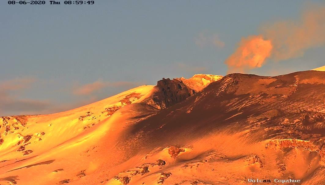
Chile , Copahue :
The National Geology and Mining Service (Sernageomin) reported this Thursday, October 24, the decision to declare a yellow alert for the Copahue volcano, located on the border of Chile with Argentina, in the Biobío region.
The change, as detailed in the Sernageomin report, responds to the fact that monitoring parameters indicate an increase in the surface activity of the volcano, with episodes of incandescence and thermal anomalies, added to the emission of ash.
The document adds that although seismic activity has not presented significant changes, since last October 15, a slight increase has been recorded. According to the current state of volcanic activity, the continuous emission of ash from the El Agrio crater is expected to continue.
« What has been reported by the Copahue Volcano monitoring stations means that our professionals have evaluated and decided to raise the alert from green to yellow. However, the most remarkable thing in this type of situation is that Sernageomin has a solid national volcanic monitoring network that monitors, 24 hours a day, the 43 most active massifs in the country from the Southern Andean Volcanological Observatory (Ovdas), » said Patricio. Aguilera, national director of the public body.
To the above, Aguilera added that, thanks to this type of online monitoring, the institution is able to instantly report to the authorities and citizens any abnormal situation on said volcanoes.
Source : Sernageomin