September 12 , 2024.
New Zealand , White Island :
Volcanic Activity BulletinWI . Thu Sep 12 2024 2:30 PM;
Volcanic Alert Level remains at 3
Aviation Colour Code remains at Orange
Images from GeoNet cameras and satellite imagery combined with data from gas-measurement flights on the 5th and 11th of September 2024, confirm that minor eruptive activity Whakaari/White Island continues.
Gas flux data from the September 5th flight point to some of the highest measured sulphur dioxide (SO2) emissions in the last 20 years. However, data from the 11th show a decrease which is consistent with other observations of the plume. Taking these variations into consideration, the total gas output from the volcano remains higher than normal.
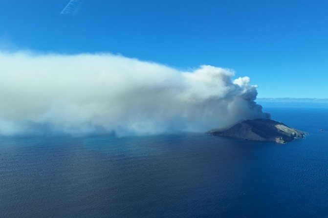
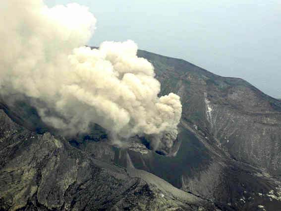
Image of the gas and ash plume at Whakaari White Island on 5 September 2024. Ash fall from the plume was only noted near the island. Credit A Mazot.
Observations form yesterday’s flight show the vent area has enlarged slightly and the emissions are now more variable. On Wednesday 11th the GeoNet camera images showed a higher and darker plume, suggesting that the amount of volcanic ash had increased substantially, while this morning the images indicate a lot less ash is present. The plumes have been rising to a few hundred metres above the volcano before being dispersed tens of kilometres downwind by local winds. Although the plume sometimes reached a kilometre above the island, the ash from it has been falling only within 1 – 3 km of the island and the likelihood of ash fallout on the mainland remains very low. The Volcanic Alert Level remains at Level 3 (minor eruption) and the Aviation Colour Code remains at Orange.
With clear views, GeoNet cameras at Whakatāne and Te Kaha have showed a continuous volcanic plume and using satellite imagery, NZ MetService have tracked the plume for tens to over 100 kilometres downwind of the volcano. Under some conditions the plume has passed over the land.
Our observations and data indicate small changes in the eruptive activity have occurred over the last 7-10 days. Strong emission of volcanic gases with small amounts of ash continues and is variable through time. The vent area changed shape sometime be-tween the 5th and 11th of this month. Our observations and the high emissions of hot gas, indicate magma (molten rock) remains likely to be close to the surface and releasing its gases with some minor amount of volcanic ash. Although the vent area has changed slightly and the amount of gas and ash varies through time, the ongoing eruption broadly appears to be of small size and quite steady. The size of the ash grains sampled on September 5th and 11th flights was measured at between 0.005 mm and 0.05 mm (5 to 50 thousandths of a millimetre) in size.
With changing wind directions, NZ MetService advise us and the aviation industry that there is sometimes a chance that the plume will be blown towards the Bay of Plenty and East Cape coast. Consequently, there have been some precautionary disruptions to flights. People living in the coastal regions might notice a slight sulphur smell from the volcano plume when winds blow the plume inland. Currently, the small amount of ash carried in the plume and its very fine grain size, means there is a very low likelihood of ash falling to the ground in coastal areas of the north island. The level of volcanic activity would have to escalate significantly for this likelihood to increase.
GNS Science’s Volcano Monitoring Group and National Geohazards Monitoring Centre will continue to closely monitor volcanic activity at Whakaari with remote cameras, satellite imagery, and regular monitoring flights. We will provide updates when information becomes available.
The Wellington VAAC reported ongoing low-level ash emissions from Whakaari/White Island during 4-10 September based on satellite data, webcam views, and weather models. The plumes rose 0.9-1.5 km (3,000-5,000 ft) a.s.l. and drifted N, NE, E, and SE. Views were sometimes obscured by weather clouds.
Source : Geonet / Michael Rosenberg / Duty Volcanologist , GVP.
Photos : Geonet / A Mazot , Bradd Scott / Geonet (27/08/2024)
Indonesia , Lewotobi Laki-laki :
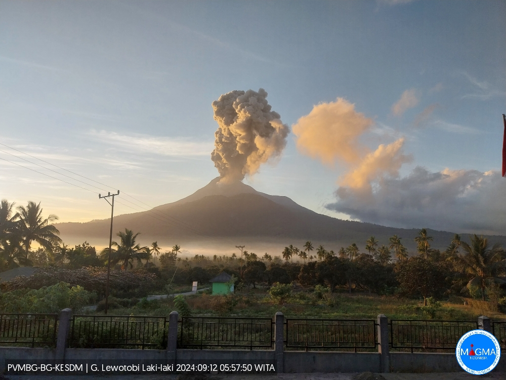
An eruption of Lewotobi Laki Laki occurred on Thursday, September 12, 2024 at 05:54 WITA with the height of the ash column observed at ± 800 m above the summit (± 2384 m above sea level). The ash column was observed to be gray with a thick intensity, oriented to the West and Northwest. This eruption was recorded on a seismograph with a maximum amplitude of 7.4 mm and a duration of 316 seconds.
VOLCANO OBSERVATORY NOTICE FOR AVIATION – VONA
Issued : September 11 , 2024
Volcano : Lewotobi Laki-laki (264180)
Current Aviation Colour Code : ORANGE
Previous Aviation Colour Code : orange
Source : Lewotobi Laki-laki Volcano Observatory
Notice Number : 2024LWK493
Volcano Location : S 08 deg 32 min 20 sec E 122 deg 46 min 06 sec
Area : East Nusa Tenggara, Indonesia
Summit Elevation : 5069 FT (1584 M)
Volcanic Activity Summary :
Eruption with volcanic ash cloud at 21h54 UTC (05h54 local).
Volcanic Cloud Height :
Best estimate of ash-cloud top is around 7629 FT (2384 M) above sea level or 2560 FT (800 M) above summit. May be higher than what can be observed clearly. Source of height data: ground observer.
Other Volcanic Cloud Information :
Ash cloud moving from southwest to west. Volcanic ash is observed to be gray. The intensity of volcanic ash is observed to be thick.
Remarks :
Eruption recorded on seismogram with maximum amplitude 7.4 mm and maximum duration 316 second.
Source et photo : Magma Indonésie.
Japan , Suwanosejima :
JMA reported that eruptive activity at Suwanosejima’s Ontake Crater continued during 2-9 September and crater incandescence was observed nightly in webcam images. The seismic network recorded 12 explosions and numerous eruptive events. Occasional rumbling and ashfall were reported at the Suwanosejima Branch Office in Toshima village (3.5 km SSW) on unspecified dates. The explosions were recorded at 20h27 on 2 September, at 11h03 and 23h04 on 4 September, at 04h25, 16h02, and 17h36 on 5 September, at 05h41, 19h38, and 20h36 on 6 September, at 21h21 on 7 September, at 21h44 on 8 September, and at 17h28 on 9 September. The explosions generated ash plumes that rose 0.4-1.7 km above the crater rim and drifted NW, W, and SW; details about the last two explosions were unknown. Large blocks were sometimes ejected as far as 600 m from the vent. As many as 11 daily eruptive events were also recorded and produced ash plumes that rose as high as 1.6 km above the crater rim and drifted NW, W, and SW. The Alert Level remained at 2 (on a 5-level scale) and the public was warned to stay at least 1.5 km away from the crater.
The 8-km-long island of Suwanosejima in the northern Ryukyu Islands consists of an andesitic stratovolcano with two active summit craters. The summit is truncated by a large breached crater extending to the sea on the E flank that was formed by edifice collapse. One of Japan’s most frequently active volcanoes, it was in a state of intermittent Strombolian activity from Otake, the NE summit crater, between 1949 and 1996, after which periods of inactivity lengthened. The largest recorded eruption took place in 1813-14, when thick scoria deposits covered residential areas, and the SW crater produced two lava flows that reached the western coast. At the end of the eruption the summit of Otake collapsed, forming a large debris avalanche and creating an open collapse scarp extending to the eastern coast. The island remained uninhabited for about 70 years after the 1813-1814 eruption. Lava flows reached the eastern coast of the island in 1884. Only about 50 people live on the island.
Sources : Japan Meteorological Agency (JMA) , GVP.
Photo : JMA ( Taken from a helicopter of Kagoshima Prefecture , 05/2001) .
Chile , Laguna del Maule :
Seismology
The seismological activity of the period was characterized by the recording of:
3048 VT type seismic events, associated with rock fracturing (Volcano-Tectonic). The most energetic earthquake had a Local Magnitude (ML) value equal to 3.1, located 2.5 km to the South-Southeast and with a depth of 9.8 km from the center of the lagoon.
8 LP type seismic events, associated with fluid dynamics inside the volcanic system (Long Period). The size of the largest earthquake evaluated from the Reduced Displacement (DR) parameter was equal to 3 cm2.
6 TR type seismic events, associated with the dynamics maintained over time of fluids inside the volcanic system (TRemor). The size of the largest earthquake evaluated from the Reduced Displacement (DR) parameter was equal to 8 cm2.
Fluid Geochemistry
No anomalies have been reported in sulfur dioxide (SO2) emissions into the atmosphere in the area near the volcanic complex, according to data published by the Tropospheric Monitoring Instrument (TROPOMI) and the Ozone Monitoring Instrument (OMI) Sulphur Dioxide Group.
Thermal anomalies by satellites
During the period, no thermal alerts were recorded in the area associated with the volcanic complex, according to the analytical processing of Sentinel 2-L2A satellite images, in combination with false-color bands.
Geodesy
The geodesic activity of the period was characterized by:
– Deformation rates similar to the historical values observed in the complex, only with a slight decrease, which does not lead to an obvious change in the deformation behavior.
The activity remained at levels considered low, suggesting a stability of the volcanic complex. The volcanic technical alert is maintained at:
GREEN TECHNICAL ALERT: Active volcano with stable behavior – There is no immediate risk
Observation:
The area concerned is considered to be the one located within a radius of 2 km around the passive CO2 degassing zone.
Source : Sernageomin
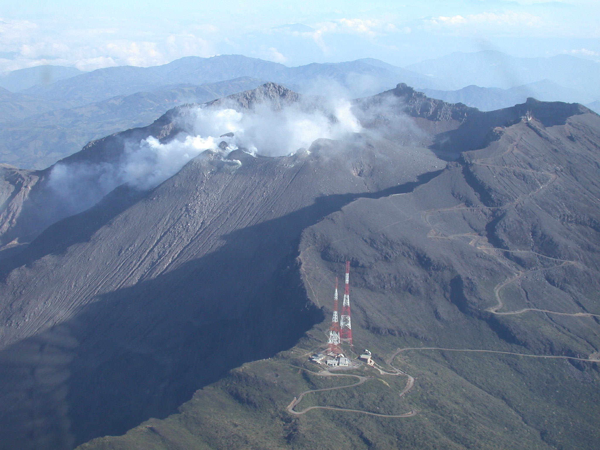
Photo : Claudio Arriagada
Colombia , Galeras :
San Juan de Pasto, September 10, 2024, 5:45 p.m.
From the monitoring of the activity of the Galeras volcano, the Colombian Geological Survey (SGC), an entity attached to the Ministry of Mines and Energy, reports that:
During the week of September 3 to 9, 2024, the activity of the volcano maintained a stable behavior. Compared to the previous week, the main variations in the monitored parameters were:
● A decrease in the frequency of earthquakes was recorded, with a slight increase in their released energy.
● The predominance of seismicity associated with the fracture of the rock material remained, within the volcanic system.
● The fracture earthquakes were located in different sectors of the volcanic edifice and with depths of up to 16 km from the Galeras peak. The event with the highest energy level recorded on September 9 at 12:09 was located about 15 km northeast of the crater, with a depth of 9 km and a magnitude of 2.6. No felt earthquakes were reported.
● Low gas emissions have been maintained, mainly from the fumarole fields of Las Chavas, to the West; El Paisita, to the North of the crater, as well as from the main crater, with columns of white gas, of variable height and dispersion due to the action of the winds.
● The other volcanic monitoring parameters have shown stability.
Based on the above, the SGC recommends closely monitoring its evolution through the weekly bulletins and other information published through our official channels, as well as the instructions of the local and departmental authorities and the National Disaster Risk Management Unit (UNGRD).
Volcanic activity remains in yellow alert status: active volcano with changes in the behavior of the base level of the monitored parameters and other manifestations.
Source et photo : Ingeominas.