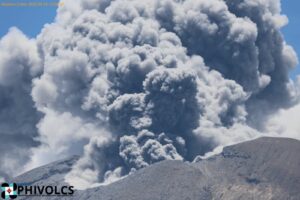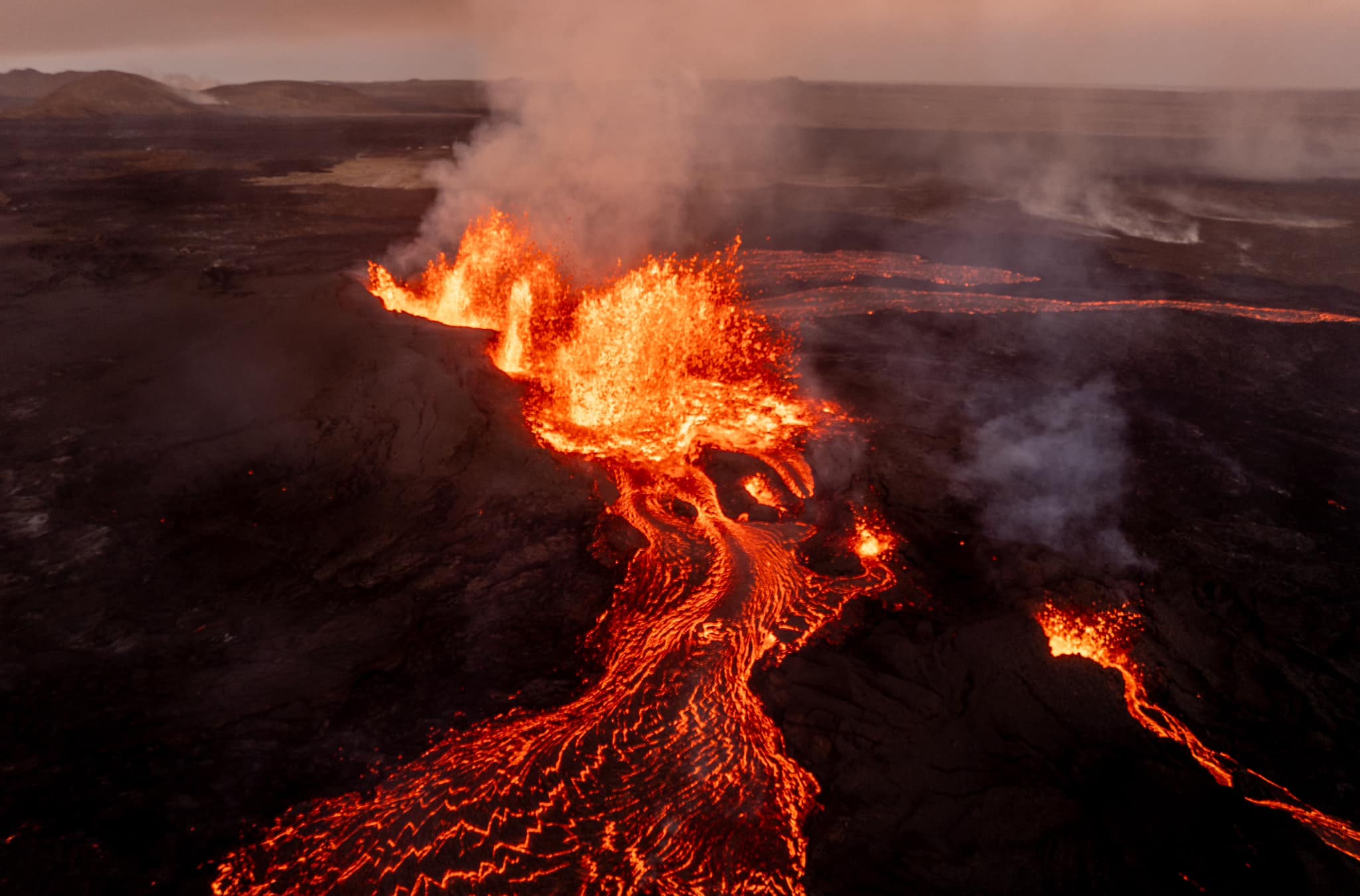
August 27 , 2024.
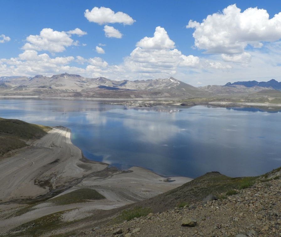
Iceland : Reykjanes Peninsula :
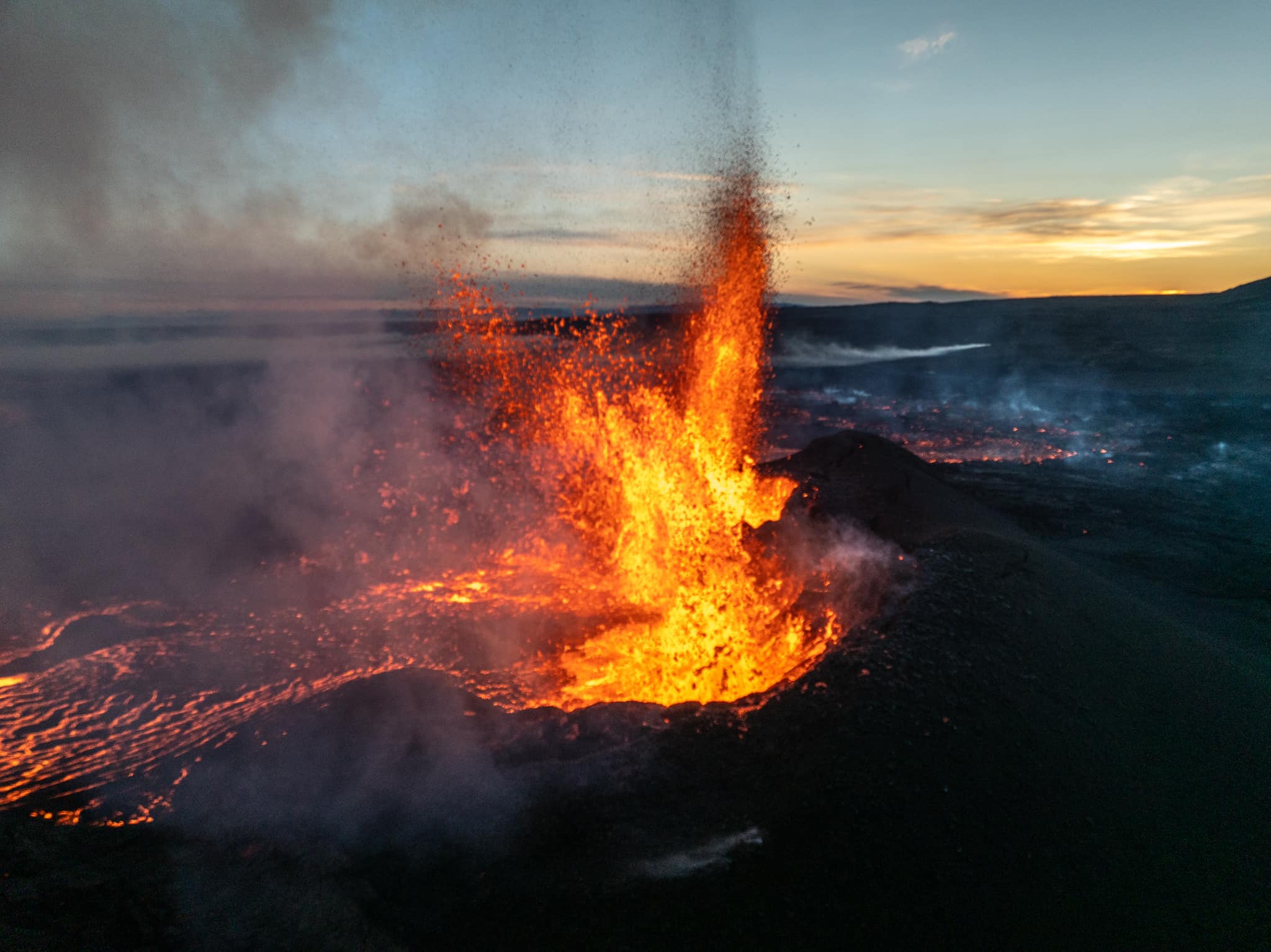
Largest volcanic eruption in Sundhnúks crater series
Land uplift is still being measured at Svartsengi. Updated on 26 August at 14:45
The eruption continues in the area northeast of Stóra-Skógfell
At the beginning of the eruption, the lava flow was estimated at about 1,500 to 2,000 m3/s. It is now several tens of cubic metres per second
The land subsided by about 40 cm as the magma from Svartsengi moved towards the Sundhnúks crater series on the evening of 22 August.
All measurements indicate that this eruption will be the largest since autumn 2023.
The lava bed area has reached 15.1 km
According to gas dispersion predictions, pollution from the eruption and forest fires will include Svartsengi, Reykjanesbær and Vogur.
All measurements indicate that this eruption is the largest in the region since the unrest began in autumn 2023. Measurements have been made so far on the lava bed and model calculations estimate the amount of magma that moved from Svartsengi to the Sundhnúks Crater Series at the start of the eruption.
The eruption continues in the area northeast of Stóra-Skógfell. During the last day, activity has become somewhat isolated in an area north of the fissure that opened on the evening of 22 August.
The lava is now flowing mainly towards the northwest in two main currents and has slowed its progression considerably.

The lava flow from the eruption can be assumed to be several tens of cubic meters per second. Exact measurements have not yet been made, but the assessment is based on a comparison with previous eruptions in the area and a visual assessment of the activity in the craters. At the beginning of the eruption, the lava flow is estimated to have been about 1,500 to 2,000 m3/s, so the current activity is only a fraction of what it was at the beginning.
When the magma flowed from Svartsengi to the Sundhnúks crater series on Thursday evening, the land subsided by about 40 cm. This is almost double the subsidence measured on May 29 during the last eruption, which is consistent with this being the largest event. The movement of magma continues but is decreasing day by day. If we assume that the magma flow rate on Saturday was reduced to 100 m3/s, then the decreasing rate of infiltration indicates that the flow rate is now reduced to about ¼ of what it was then. Model calculations indicate that 17 to 27 million cubic meters of magma have left the Svartsengi magma chamber since the start of the eruption.
It will not be possible to determine the continued flow of magma into the magma accumulation zone beneath Svartsengi until the land is visible again. This could start to be observed after the lava flow during the eruption drops below 4 m3/s, which is comparable to the inflow beneath Svartsengi as estimated so far.
Seismic activity remains low in the region and mainly at the northernmost fissure, but a M 3.4 earthquake occurred near Kleifarvatn just before midnight last night.
According to the weather forecast, the eruption centres are moving slowly towards the east today. Pollution from the eruption and the vegetation fires is expected to spread across the entire Reykjanes peninsula. It could be felt for some time, for example in the wetlands, at Svartsengi, Reykjanesbær and Vogur. Tonight, the winds will be from the southeast and east at 5 to 13 m/s and the gas will then reach the northwest and west, over Reykjanesbær. A slower direction towards the north or a change of direction tomorrow afternoon, which could lead to gas pollution in Grindavík.
Source : IMO
Photos : Jochen Felkl / FB ( 26/08/2024)
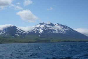
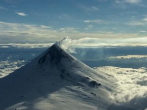
New Zealand , White Island :
Minor eruptive activity continues at Whakaari: volcanic ash emissions continue. Volcanic Alert Level remains at Level 3 and Aviation Colour Code remains at Orange.
Published: Tue Aug 27 2024 11:30 AM
An observation flight on Wednesday 21 Aug 2024 and ongoing satellite imagery confirms that minor eruptive activity Whakaari/White Island continues from the new vent that became active in early August. Satellite data further suggests that SO2 levels remain high. The amount of volcanic ash in the plume has not changed much over the last week. There remains a very low likelihood of ash falling on the ground on the mainland.
The Volcanic Alert Level remains at Level 3 (minor eruption) and the Aviation Colour Code remains at Orange.
The observation flight confirmed activity was confined to just one active vent on the island (Fig. 1). The vent was emitting a plume of fine volcanic ash that rose to about 600-900 m before being dispersed downwind. Ashfall was restricted to within 1 km of the island (Fig.1 and 2). Thermal infrared imagery captured during the flight showed a vent temperature of about 590 °C.
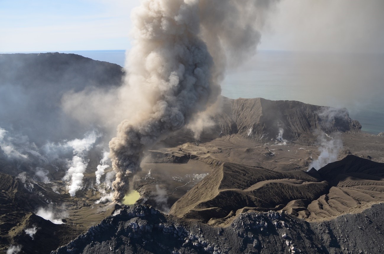
Figure 1 Picture of the Main Crater area showing the active vent with the ash emission feeding the plume at Whakaari White Island on Wednesday 21 August
In addition to our observation flight, our webcams at Whakatāne and Te Kaha have observed that the plume can reach an altitude of about 2 km under calm conditions. NZ MetService are also able to use satellite imagery to track the volcanic ash plume for tens of kilometres downwind of the volcano when skies are clear.
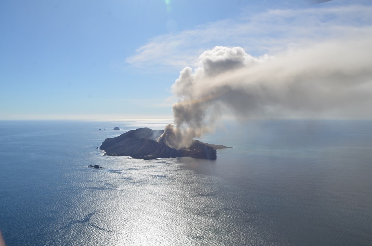
Figure 2 Picture of the ash cloud from Whakaari White Island on Wednesday 21 August
Satellite data obtained on 21 and 22 August confirm that the increase in SO2 emissions from Whakaari that we previously reported has continued. A further satellite-based monitoring technique which can detect deformation of the ground surface shows no major changes in the active vent area.
Our observations and data confirm there has been little change in the eruptive activity over the last 7-10 days. Small amounts of volcanic ash continue to be emitted into the plume and SO2 emissions remain elevated. Although looking spectacular, the ongoing eruption is small and the concentration of volcanic ash in the plume is very low and sometimes difficult to detect. Overall, the activity is consistent with magma (molten rock) being close to the surface and driving the activity.
As wind directions change, the plume may at times be blown towards the Bay of Plenty coast and pass overhead as happened on Thursday and Friday last week (22 and 23 August). However, at the current level of ash emission, there is a very low likelihood of some of that ash falling to the ground (ashfall). The level of volcanic activity would have to escalate significantly for this likelihood to increase.
Source : Geonet / Paul Jarvis / Duty Volcanologist.
Photos : Bradd Scott / Geonet. (26/08/2024)
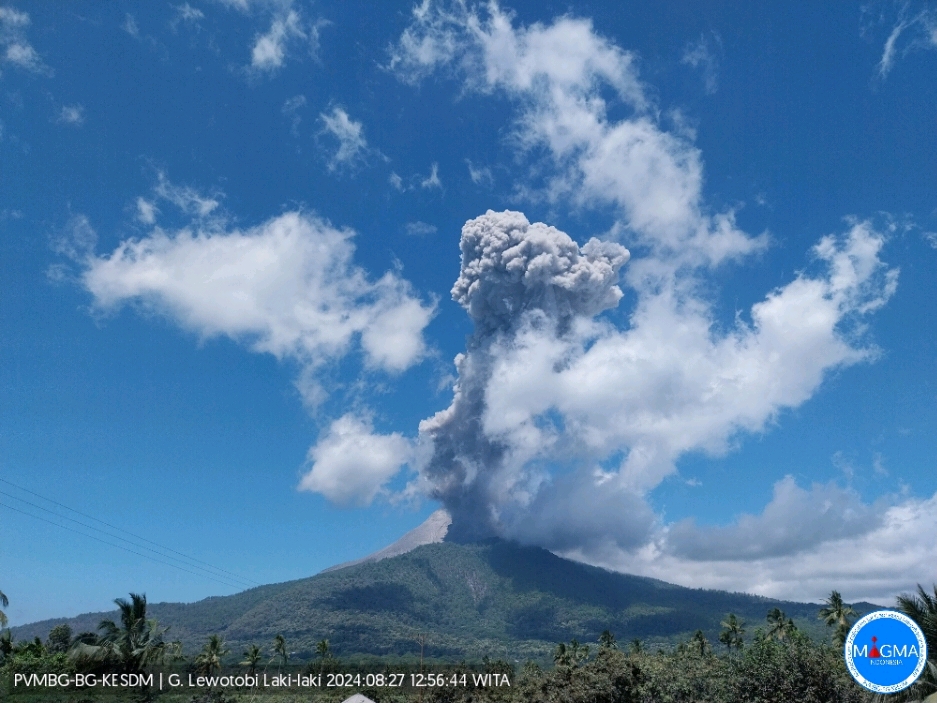
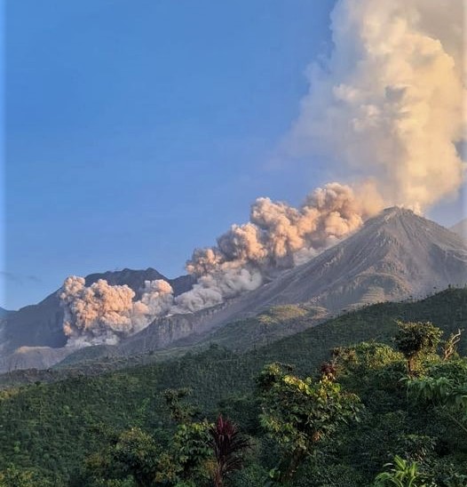
Indonesia , Lewotobi Laki-laki :
An eruption of Lewotobi Laki-laki occurred on Tuesday, August 27, 2024, at 12:53 WITA with the height of the ash column observed at ± 900 m above the summit (± 2484 m above sea level). The ash column was observed to be gray in color with a thick intensity, oriented towards the northwest. This eruption was recorded on a seismograph with a maximum amplitude of 22.2 mm and a duration of 255 seconds.
VOLCANO OBSERVATORY NOTICE FOR AVIATION – VONA
Issued : August 27 , 2024
Volcano : Lewotobi Laki-laki (264180)
Current Aviation Colour Code : ORANGE
Previous Aviation Colour Code : orange
Source : Lewotobi Laki-laki Volcano Observatory
Notice Number : 2024LWK414
Volcano Location : S 08 deg 32 min 20 sec E 122 deg 46 min 06 sec
Area : East Nusa Tenggara, Indonesia
Summit Elevation : 5069 FT (1584 M)
Volcanic Activity Summary :
Eruption with volcanic ash cloud at 04h53 UTC (12h53 local).
Volcanic Cloud Height :
Best estimate of ash-cloud top is around 7949 FT (2484 M) above sea level or 2880 FT (900 M) above summit. May be higher than what can be observed clearly. Source of height data: ground observer.
Other Volcanic Cloud Information :
Ash cloud moving to northwest. Volcanic ash is observed to be gray. The intensity of volcanic ash is observed to be thick.
Remarks :
Eruption recorded on seismogram with maximum amplitude 22.2 mm and maximum duration 255 second.
Source et photo : Magma Indonésie
Chile , Laguna del Maule :
Special Report on Volcanic Activity (REAV), Maule Regions, Laguna del Maule Volcanic Complex, August 26, 2024, 23:00 local time (Continental Chile)
The National Geology and Mining Service of Chile (Sernageomin) announces the following PRELIMINARY information, obtained through the monitoring equipment of the National Volcanic Monitoring Network (RNVV), processed and analyzed at the Southern Andean Volcano Observatory (Ovdas):
On Monday, August 26 at 22:00 (02:00 UTC), the monitoring stations installed near the Laguna del Maule volcanic complex recorded a volcano-tectonic seismic swarm (associated with rock fracturing). At the time of issuing this report, there are more than 100 classified events.
The characteristics of the largest earthquake after its analysis are as follows:
TIME OF ORIGIN: 22:00 local time (02:00 UTC on August 27)
LATITUDE: 36.078833° S
LONGITUDE: 70.4951° West
DEPTH: 9.9 km
LOCAL MAGNITUDE: 3.1 (ML)
Observation:
Since 21:57 local time, an increase in volcano-tectonic seismic activity (associated with rock fracturing) has been observed. This episode began with a local magnitude (ML) event of 2.9, and subsequently, at 22:00 local time (02:00 UTC on August 27), the main event of local magnitude ML of 3.1 was recorded. At the time of this report, seismicity of lower energy and occurrence is observed.
The volcanic technical alert is maintained at GREEN level.
Source et photo : Sernageomin
Guatemala , Santiaguito :
Atmospheric conditions: Clear.
Wind: Northeast.
Precipitation: 12.0 mm.
Activity:
The Santa María-Santiaguito Volcanic Complex Observatory reports volcanic activity on the Caliente Dome. During the night and early morning, some moderate explosions were observed that raised columns of gas and ash up to 800 meters high above the dome and moved towards the West and Southwest, as well as the incandescence of lava extrusion, block avalanches and pyroclastic flows over short distances towards the West, Southwest, South and East flanks, from the dome to the base of the dome. The stacking of this pyroclastic material on these flanks forms a promontory above the lava flow of the year 2022 that occupies the Zanjón Seco and San Isidro channels.
Degassing is constant, with weak to moderate columns of water vapor and other magmatic gases rising 300 meters above the dome, moving toward the west and northwest. Due to the wind direction, weak ash falls could occur over Santo Domingo, Montebello, Loma Linda and San Marcos Palajunoj. In the afternoon and evening, rains could cause lahars to descend into the channels that descend from the Caliente dome. Activity remains at a high level, so there remains the possibility that with the explosions or under the effect of gravity, part of the accumulated material will collapse and long-distance pyroclastic flows will be generated toward the southwest, south and southeast.
Source : Insivumeh
Photo : Edgar Cabrera / CONRED ( archive 02/2022).