August 24 , 2024.
Iceland , Reykjanes Peninsula :
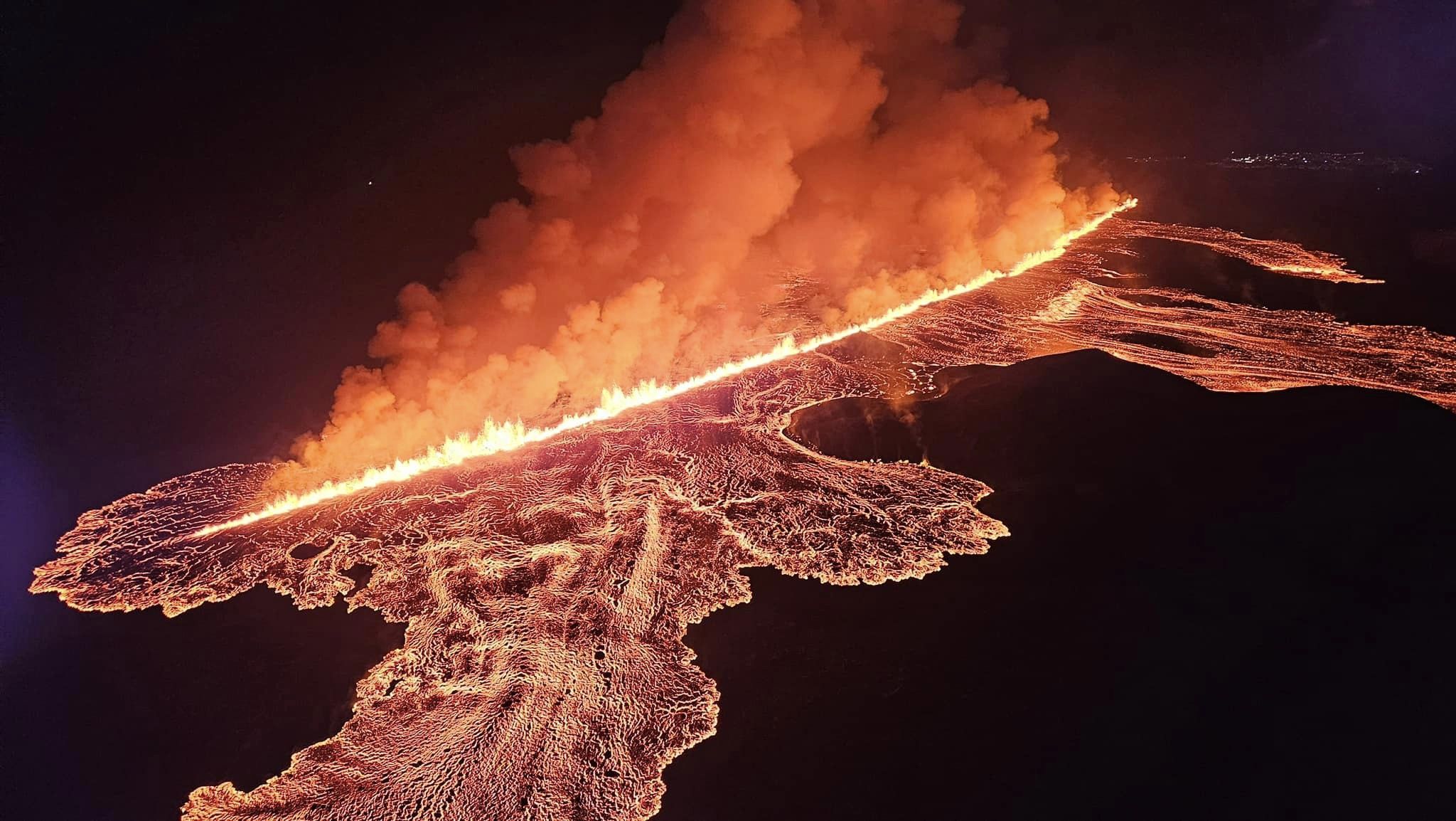
Updated 23 August at 01:00 UTC
The length of the eruptive fissure appears to remain the same for the last hour (approx. 3.9 km).
The seismicity is fairly stable, and the main activity is at the northern end of the eruptive fissure. It is therefore unlikely that the fissure will extend to the south. It cannot be ruled out that the eruptive fissure could extend to the north.
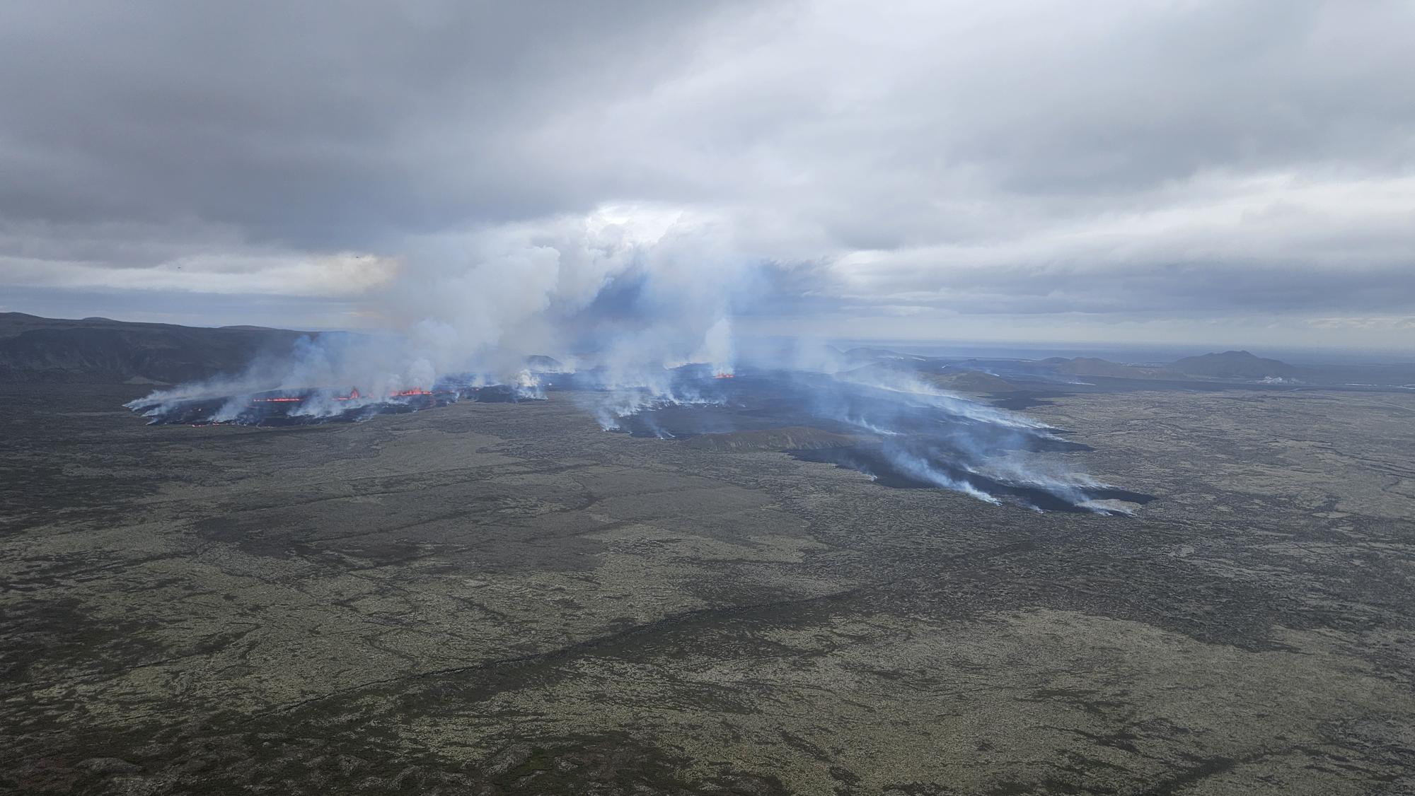
The lava flow continues both to the east and west towards Grindavíkurvegur. No lava flow is observed to the south towards Grindavík.
The Coast Guard will carry out another surveillance flight later tonight.
The next update will be provided tomorrow morning. IMO maintains a 24-hour monitoring of all natural hazards and will publish posts on Facebook later in the night with the latest information about the volcanic activity.
Updated 23. August at 10:00 UTC
The vigor of the eruption has decreased somewhat since its peak yesterday.
The activity is now mostly confined to two fissures, the northern end of the fissure that erupted first and the fissure that opened north of the first one.
Seismicity decreased rapidly after 4 A.M. However, ground extension continues north of Stóra-Skógfell, which suggests that the eruption has not reached equilibrium.
The eruption in Sunhnúks crater row continues
The main activity occurs at two sites North of Stóra-Skógfells
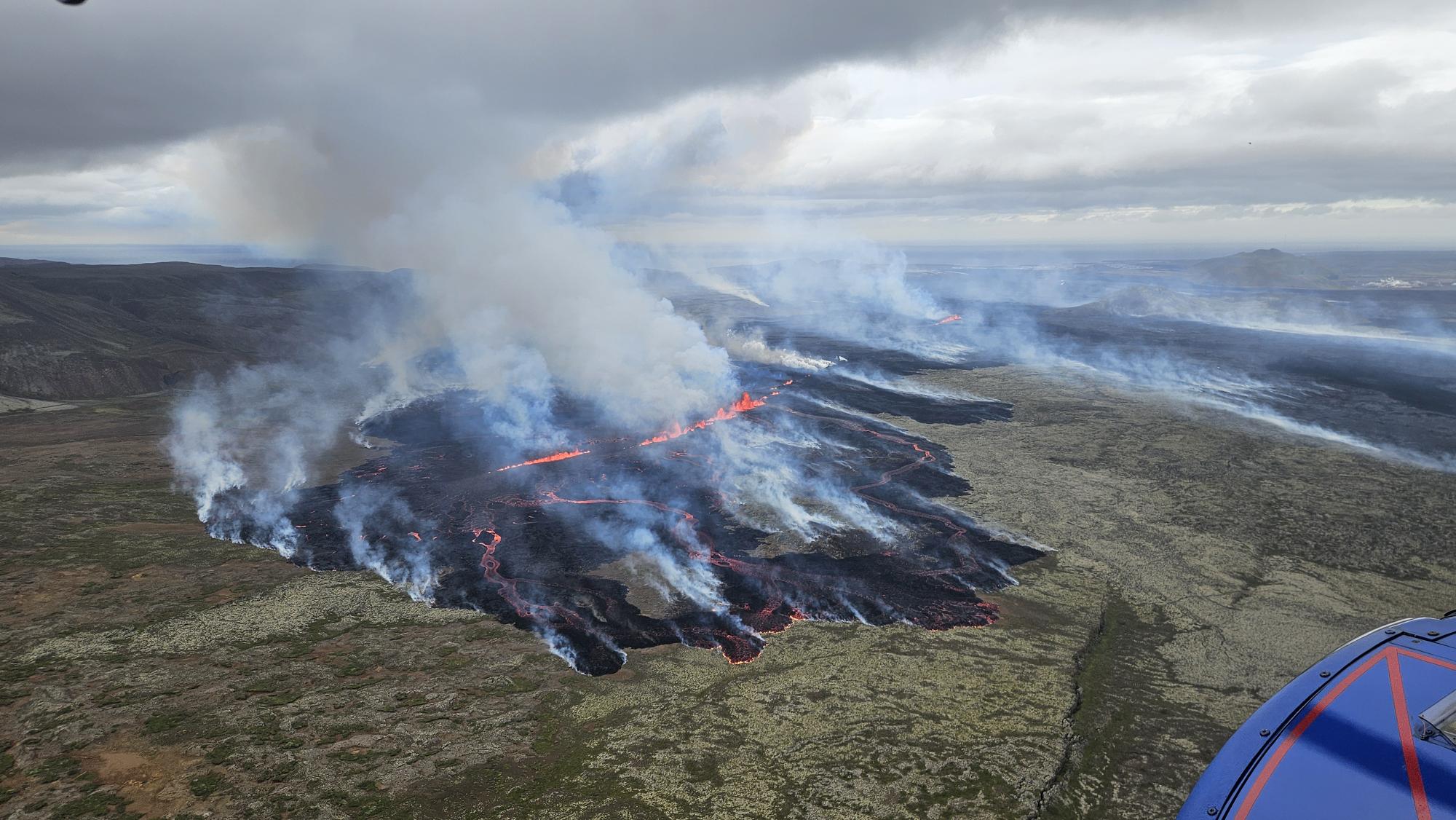
Updated 23 August at 16:00 UTC
The intensity of the eruption has decreased significantly since yesterday
The main activity is now limited to two areas
The most active fissure is the one which opened during the night
No activity south of Stóra-Skógafell
Volcanic gas and ash are transported to the south
The seismic activity and ground deformation rate at the eruption site has slowed down. Today (23 August) the eruptive activity has been primarily occurring north of Stóra-Skógafell.
According to information from the Icelandic Coast Guard’s surveillance flights, that flew at midday today, the main activity is limited to two areas north of Stóra-Skógafell.
A photo from a surveillance flight taken by the Icelandic Coast Guard just after noon today, looking over the northernmost part of the eruption fissure.
The fissure that opened at the beginning of the eruption is now characterized by very low activity. Only a small fissure appears to be erupting on a small section directly east of Stóra-Skógafell. Activity seems to be reducing to a few demarcated areas, as happened in previous eruptions. The lava tongue that approached the Grindavíkurvegur road at the beginning of the eruption has therefore almost stopped.
A photograph from the Icelandic Coast Guard’s surveillance flight this morning. Looking south. Þorbjörn and Svartsengi can be seen in the distance on the right side of the picture.
Most of the flow of lava has been progressing to the northwest, as can be seen in the above photograph and the map that was published before noon in the previous news.
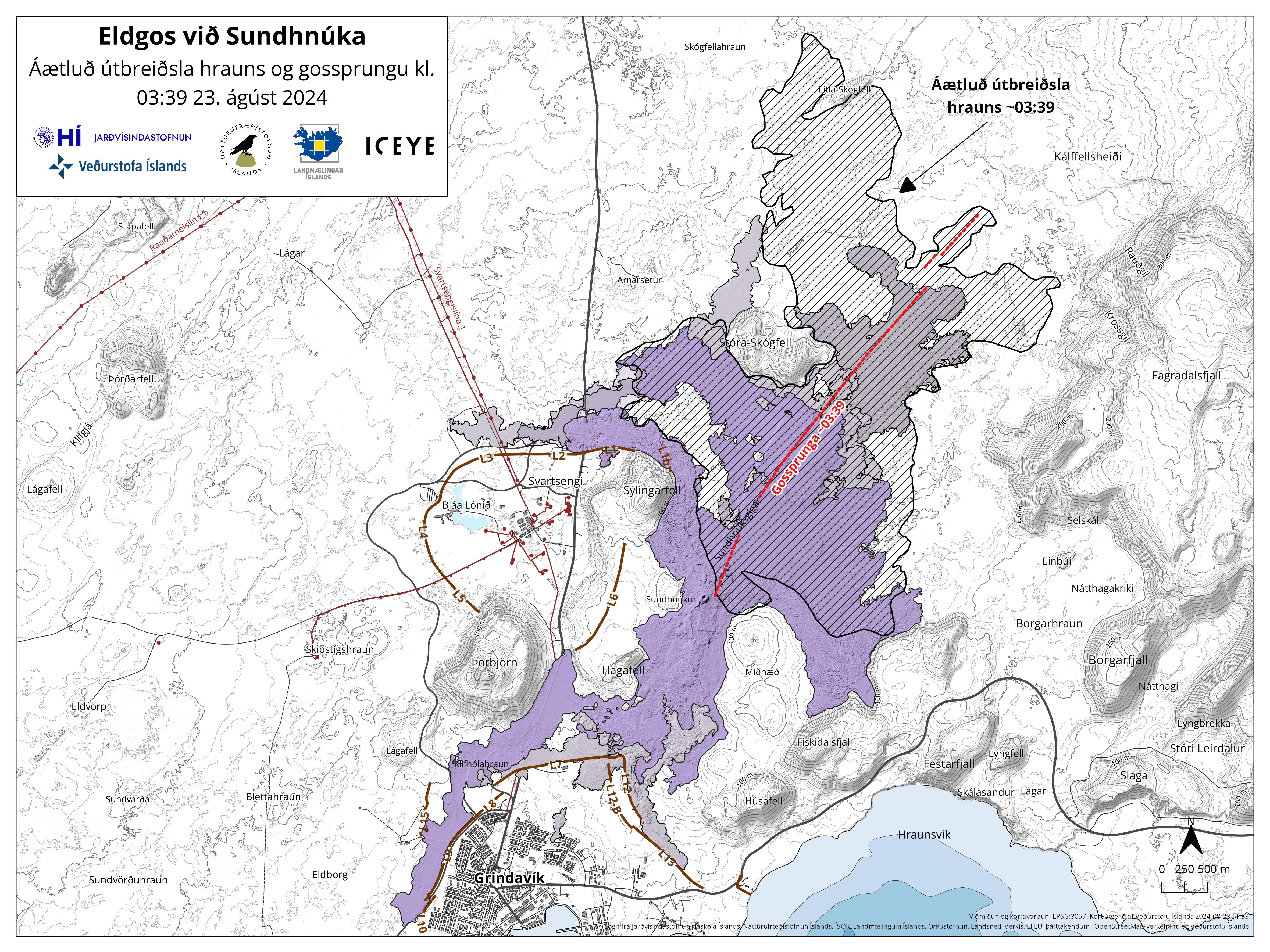
Map showing the extent of the lava flow (hatched area) formed during this eruption and the location of the eruptive fissure (red line) as it was at 03:39 last night. Also shown are the lava fields that have formed in the area since December 2023 (purple layers). The map is based on data from the IcEYE satellite.
The propagating lava flow is causing extended wildfires in the area. The pollution caused by this eruption is transported fast to the south. Satellite images from today (Sentinel 5p) show the SO2 cloud travelling farer than 1,000 kilometers toward Scotland.
Source : IMO
Photos : Guide to Iceland , Almannavarnir/Björn Oddsson , IMO.
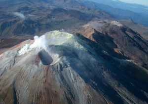
Kamchatka , Sheveluch :
56.64 N, 161.32 E;
Elevation 3283 m (10768 ft), the dome elevation ~2500 m (8200 ft)
Aviation Colour Code : ORANGE
An extrusive-effusive eruption of the Sheveluch volcano continues. Ash explosions up to 10 km (32,800 ft) a.s.l. could occur at any time. Ongoing activity could affect international low-flying aircraft.
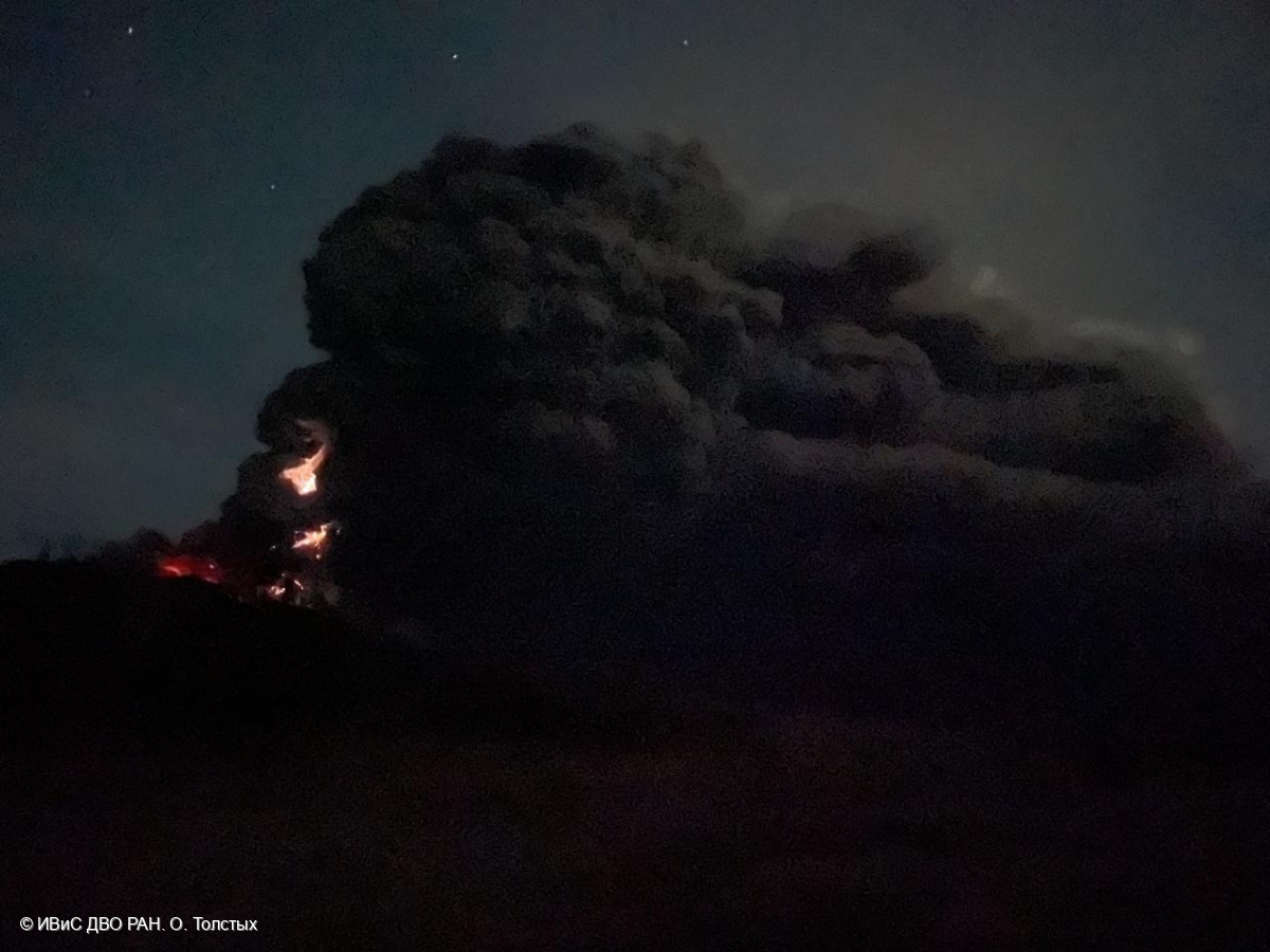
The eruptive column and ash plume above the Karan lava dome area of Sheveluch volcano on August 17, 2024.
The extrusive-effusive eruptions of the Young Sheveluch volcano and two centers in the area of the Karan dome (lava domes 300 years of the Russian Academy of Sciences and a New) continue. According to video-visual and satellite data by KVERT, an explosive eruption in the area of the Karan dome on the southwestern slope of the Old Sheveluch volcano with ash removal up to 9 km a.s.l. and the formation of two centers began at 10:16 UTC on 17 August. Ash plumes and clouds moved more than 2400 km to the east of the volcano during 17-19 August. A plume of resuspended ash extended 200 km to the southeast of the volcano on 20-21 August. A thermal anomaly in the area of the volcano was observed on 16-19 and 21 August; the volcano was covered by clouds in the other days of the week.
Source : Kvert
Photo : O. Tolstykh, IVS FEB RAS ( 17/8/2024)
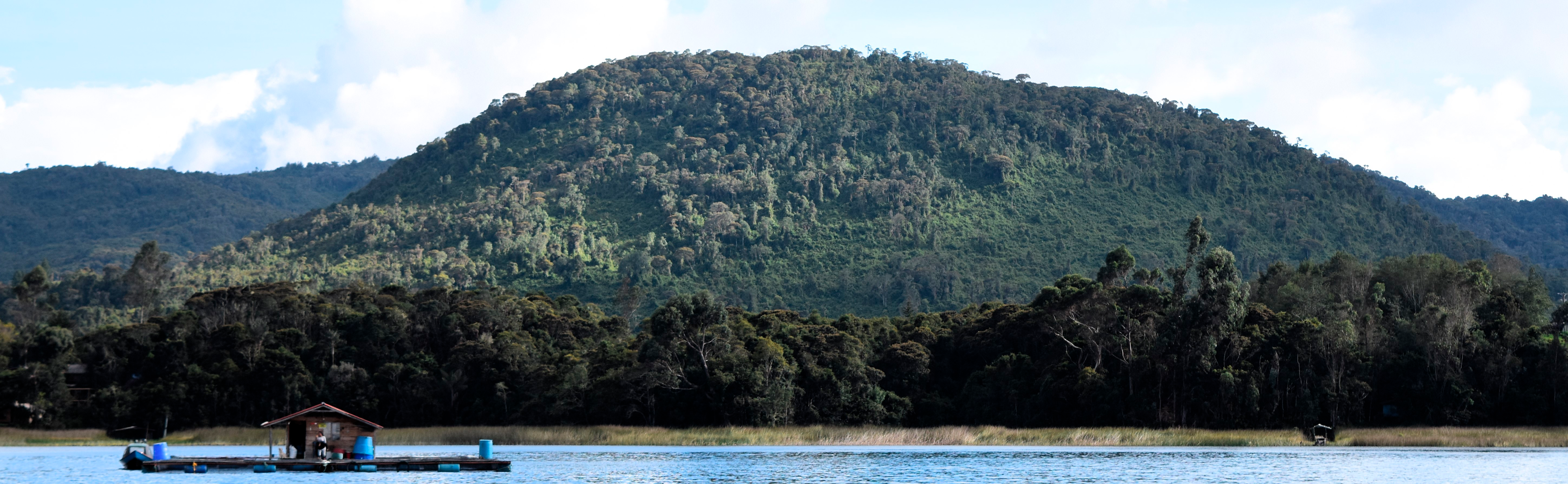
Indonesia , Merapi :
MOUNT MERAPI ACTIVITY REPORT from August 16 to 22, 2024 . Published on August 23, 2024
OBSERVATION RESULT
Visual
The weather around Mount Merapi is generally clear in the morning and night, while it is foggy from noon to evening. White smoke, thin to thick, low to moderate pressure and 450 m high was observed from the Kaliurang Mount Merapi observation post on August 17, 2024 at 11:30 WIB. This week, 6 hot clouds descended to the southwest (upstream of the Bebeng River) with a maximum sliding distance of 1,400 m. Lava avalanches were observed 314 times upstream of Bebeng River up to a maximum of 1,900 m, 2 times upstream of Boyong River to the south up to a maximum of 1,000 m, 1 time upstream of Batang River to the west up to 1,000 m, and 1 time upstream of Kali Apu to the northwest up to 500 m. The sound of avalanches was heard 22 times from Babadan station with low to moderate intensity.
The morphology of the southwest dome was observed to change due to dome growth activities, lava avalanches, and hot cloud avalanches. The highest hot spot was observed at 243 °C, which is relatively the same as the previous measurement temperature. For the morphology of the middle dome, there is no significant morphological change. The highest hot spot was observed at 215.4 °C, which is lower than the previous measurement temperature. Based on the analysis of aerial photos, the volume of the southwest dome was measured at 2,777,900 m3 and that of the central dome at 2,366,900 m3.
Seismicity
This week, the seismicity of Mount Merapi recorded:
6 hot cloud avalanche (WCA) earthquakes,
16 shallow volcanic earthquakes (SVA),
70 multi-phase (MP) earthquakes,
1 low frequency (LF) earthquake,
1,013 avalanche (RF) earthquakes,
12 tectonic earthquakes (TT).
The intensity of earthquakes this week is higher than last week.
Deformation
The deformation of Mount Merapi monitored by EDM this week shows an average shortening rate of 0.3 cm/day, relatively the same as last week.
Rainfall and Lahars
This week, there was no rain at the Mount Merapi observation post and no additional runoff or lahars were reported in the rivers that originate on Mount Merapi.
Conclusion
Based on the results of visual and instrumental observations, it was concluded that:
The volcanic activity of Mount Merapi is still quite high in the form of effusive eruptive activity. The activity status is set at the « SIAGA » level.
Source : BPPTKG
Photo : Abdllah Evan via Alicja Szojer FB
Colombia , Guamuez-Sibundoy volcanic field :
Pasto, August 23, 2024, 3:30 p.m. Guamuez – Sibundoy Volcanic Field
Activity recorded between August 15 and 23, 2024
Regarding the monitoring of seismic activity recorded from August 15 to the date of publication of this bulletin, in the area of La Cocha Lagoon (Nariño department), it is reported that earthquakes associated with rock fracture processes within the area continue to be recorded, associated with rock fracture processes within the crust.
966 earthquakes were recorded, among which 34 of magnitude greater than or equal to 2.0 stand out, and three of them of magnitude 3.5 (August 17 at 8:21 a.m.), 3.0 (August 20 at 12:42 p.m.) and 3.3 (August 21 at 10:50 a.m.).
Among the most energetic earthquakes, 11 were reported by residents of the municipality of Santiago (Putumayo), as well as the areas surrounding the La Cocha lagoon and the municipality of Pasto. In addition, between last night and today, two earthquakes were recorded, the first on August 22 at 10:00 p.m., with a magnitude of 2.4, and the second on August 23 at 2:34 a.m., with a magnitude of 2.9. These earthquakes were also reported as felt in the city of Santiago and its surroundings.
It is important to clarify that in this same area, the locations of several volcanoes that are part of the volcanic field known as Guamuez – Sibundoy have been identified. These volcanoes have different characteristics from volcanoes such as Nevado del Ruiz, Galeras, Nevado del Huila. or Purace. They are characterized by the fact that they only erupt once and other volcanoes form in the same area, thus forming a volcanic field, unlike the other types of volcanoes mentioned, where the magma normally comes out of the same place (crater) and can erupt several times. .
In addition, in this sector there are also important geological faults that can interact with the volcanoes and that could be responsible for this seismicity.
It should also be noted that, since there is an instrumental record, there is a report of seismicity in this same sector (2011), with a lower number of occurrences than that presented in recent days. According to historical records of seismicity, the Guamuez-Sibundoy field has presented earthquakes of considerable magnitude, such as the one in 1834, with an estimated magnitude of 6.7.
Based on the above, the SGC recommends closely monitoring the evolution of this activity through the information published through our official channels.
The activity in the volcanic field remains in a GREEN alert state: at rest.
Source et photo : SGC
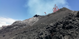
Guatemala , Santiaguito :
Latitude: 14°44′ 33˝N
Longitude: 91°34’13˝West.
Altitude: 2,500 meters above sea level.
Atmospheric conditions: partly cloudy
Wind: East
Precipitation: 15.2 mm.

Activity:
A weak degassing is observed on the crater that disperses towards the West. Weak and moderate explosions are recorded, expelling columns of gas and ash that reach up to 800 meters in height above the crater and disperse in a West and South-West direction. Weak, moderate and some strong block avalanches are recorded on the lava flow, on the South flank and on the South-East flank. In the afternoon and at night, rains could cause lahars in different channels of the volcano. Fine ash falls are reported in Aldea Loma Linda and other nearby towns in the direction of the dispersion of the ash columns. The occurrence of block and ash flows of moderate to strong characteristics is not excluded, as well as possible pyroclastic flows over long distances in different directions, therefore, it is not advisable to stay near or in the riverbeds near the foothills of the volcano.
Source : Insivumeh
Photo : Annie Winson , earthobservatory.sg, ( archive 2019)