July 23 , 2024.
Italy / Sicily , Etna :
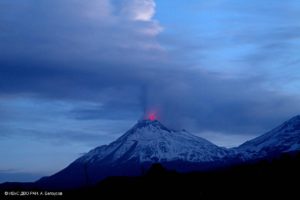
Press release on the activity of Etna, July 22, 2024, 7:20 p.m. (5:20 p.m. UTC).
The National Institute of Geophysics and Volcanology, Osservatorio Etneo, communicates that according to images from the video surveillance network, Strombolian activity is observed at the Voragine crater. Observations are severely limited due to cloud cover over the summit area. The predicted dispersion model of the possible volcanic cloud indicates an eastward direction.
For much of the day, the average amplitude of the volcanic tremor was characterized by a slight and gradual increasing trend, which became even more pronounced from around 1500 UTC. Around 15:45 UTC, the tremor amplitude reached the high value range where it is still maintained, with a tendency to continue increasing. The center of gravity of the volcanic tremor sources is located southeast of the Voragine crater, at an altitude between 2,600 and 2,800 m above sea level. Infrasound activity also showed a general upward trend during the day. The source of the infrasound events, the latter generally of medium amplitude, is located in correspondence with the Voragine crater.
Signals from ground deformation monitoring networks do not currently show significant variations.
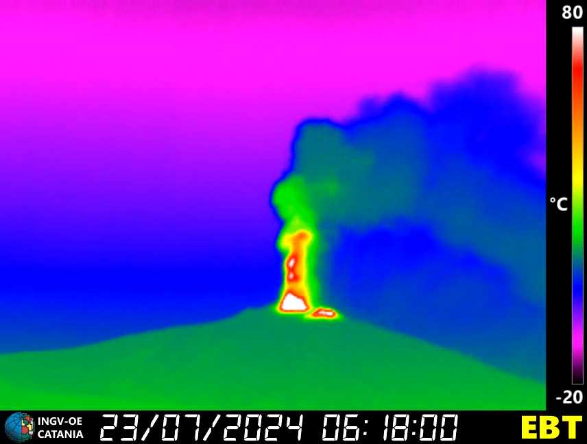
Press release on the activity of Etna, July 23, 2024, 04:08 (02:08 UTC).
The National Institute of Geophysics and Volcanology, Osservatorio Etneo, communicates that from the images of the video surveillance network, we observe that the Strombolian activity at the Voragine crater previously described in the updated press release from 17:20 UTC of 07/22 intensified in the following hours and, starting at 1:00 UTC, was particularly strong. This activity produces ash emissions which, in accordance with the forecast model, disperse in the East-South-East direction.
The average amplitude of the volcanic tremor continues to present an increase in its values and has currently reached a very high level. The centroid of the volcanic tremor sources is located just east of the Voragine crater, at an altitude of approximately 2,900 m above sea level. Since yesterday around 18 UTC, a clear increase has been noted of infrasound activity, both in number and amplitude of infrasound events. They are located in the Voragine crater.
The GNSS(HF) network currently does not show significant variations. The summit inclinometer stations show slight variations from around 00:00 UTC. Starting around 22:00 UTC on July 22, the Monte Ruvolo dilatometer shows a decompression trend.
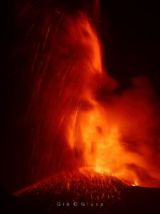
Press release on the activity of Etna, July 23, 2024, 05:08 (03:08 UTC).
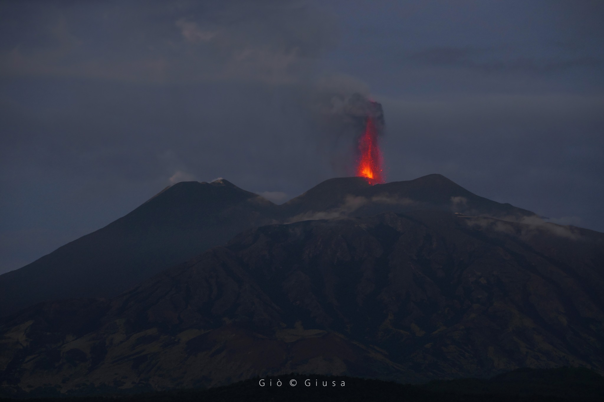
The National Institute of Geophysics and Volcanology, Osservatorio Etneo, communicates that from the images of the video surveillance network, we observe that the strong Strombolian activity at the level of the Voragine crater previously described in the press release updated at 2:08 UTC s is transformed into a lava fountain. This activity is currently underway and produces an emission of ash which, according to the forecast model, is dispersed in the East-South-East direction. We also observe that a lava overflow has started from the western edge of the Bocca Nuova crater.
From a seismic point of view, the average amplitude of the volcanic tremor has further increased. The sources of the tremor remain in the Voragine crater area, at an altitude of about 3,000 m above sea level. There is a further increase in the frequency of occurrence and amplitude infrasound events located in the Voragine crater. The amplitude of the infrasound tremor increases.
From around 02:00 UTC, the inclinometer network shows clear variations, more evident at the summit stations. The Monte Ruvolo dilatometer has accumulated a decompression equal to approximately 10 nano-strains and is currently being updated.
Further updates will be communicated shortly.
Source : INGV
Photos : INGV , Gio Giusa 23/07/2024.
Indonesia , Ibu :
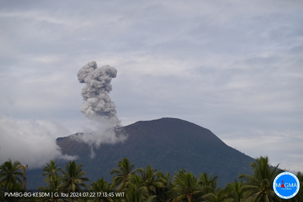
An eruption of Mount Ibu occurred on Monday, July 22, 2024 at 03:59 UTC (12:59 p.m. local) with the height of the ash column observed at ±500 m above the summit (±1,825 m above sea level). the sea). The ash column was observed to be gray to black in color with thick intensity, oriented towards the North. This eruption was recorded on a seismograph with a maximum amplitude of 28 mm and a duration of 68 seconds.
VOLCANO OBSERVATORY NOTICE FOR AVIATION – VONA
Issued : July 22 , 2024
Volcano : Ibu (268030)
Current Aviation Colour Code : ORANGE
Previous Aviation Colour Code : orange
Source : Ibu Volcano Observatory
Notice Number : 2024IBU152
Volcano Location : N 01 deg 29 min 17 sec E 127 deg 37 min 48 sec
Area : North Maluku, Indonesia
Summit Elevation : 4240 FT (1325 M)
Volcanic Activity Summary :
Eruption with volcanic ash cloud at 03h59 UTC (12h59 local).
Volcanic Cloud Height :
Best estimate of ash-cloud top is around 5840 FT (1825 M) above sea level or 1600 FT (500 M) above summit. May be higher than what can be observed clearly. Source of height data: ground observer.
Other Volcanic Cloud Information :
Ash cloud moving to north. Volcanic ash is observed to be white to gray. The intensity of volcanic ash is observed to be thick.
Remarks :
Eruption recorded on seismogram with maximum amplitude 28 mm and maximum duration 68 second.
Source et photo : Magma Indonésie.
Chile , Villarica :
Special Report on Volcanic Activity (REAV), Araucania regions, Villarica volcano, July 21, 2024, 2:10 p.m. local time (mainland Chile)
The National Geology and Mining Service of Chile (Sernageomin) announces the following PRELIMINARY information, obtained through the monitoring equipment of the National Volcanic Monitoring Network (RNVV), processed and analyzed at the Southern Andean Volcano Observatory (Ovdas):
On Sunday July 21 at 1:49 p.m. (5:49 p.m. UTC), through surveillance cameras installed near the Villarica volcano, an earthquake associated with fluid dynamics inside the volcanic system (long period type) was recorded.
The characteristics of the earthquake are as follows:
ORIGINAL TIME: 1:49 p.m. local time (5:49 p.m. UTC)
REDUCED DISPLACEMENT: 30.93 (cm*cm)
ACOUSTIC SIGNAL: 1.2 Pascals (Pa) reduced to 1 km
The characteristics of the associated surface activity are as follows:
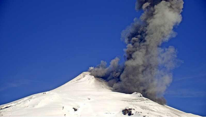
MAXIMUM HEIGHT OF THE COLUMN: 320 meters above the point of emission
DIRECTION OF SPREAD: North-East (NE)

Observation :
The ejection of pyroclastic materials began at 1:46 p.m. and a second consecutive pulse took place at 1:49 p.m., the latter linked to the long-period type event described above. Both had a preferential dispersal direction towards the Northeast (NE).
The technical volcanic alert is maintained at YELLOW level.
on Sunday July 21 at 2:38 p.m. (6:38 p.m. UTC), through surveillance cameras installed near the Villarica volcano, an ejection of pyroclastic materials was recorded following an earthquake associated with the dynamics of fluids inside the volcanic system (long period type).
The characteristics of the earthquake are as follows:
ORIGINAL TIME: 2:38 p.m. local time (6:38 p.m. UTC)
REDUCED DISPLACEMENT: 3.4 (cm*cm)
ACOUSTIC SIGNAL: 1.2 Pascals (Pa) reduced to 1 km
The characteristics of the associated surface activity are as follows:
MAXIMUM HEIGHT OF THE COLUMN: 780 meters above the point of emission
DIRECTION OF SPREAD: North-East (NE)
Source : Sernageomin.
Photos : Mario’s fishing zone Pucon-Chiles , Sernageomin .
Kamchatka , Bezymianny :
VOLCANO OBSERVATORY NOTICE FOR AVIATION (VONA)
Issued: July 22 , 2024
Volcano: Bezymianny (CAVW #300250)
Current aviation colour code: ORANGE
Previous aviation colour code: yellow
Source: KVERT
Notice Number: 2024-41
Volcano Location: N 55 deg 58 min E 160 deg 35 min
Area: Kamchatka, Russia
Summit Elevation: 2882 m (9452.96 ft)

Volcanic Activity Summary:
An extrusive eruption of the volcano increased significantly on 21 July: hot avalanches collapsed on the eastern slopes of the lava dome, and the ash from which rose up to 2-3 km a.s.l. This process continues on 22 July. Satellite data by KVERT shows a significant increase in the size and temperature of the thermal anomaly over the volcano on 22 July. Probably, ash explosions up to 10-15 km (32,800-49,200 ft) a.s.l. could occur during next 3 days.
The activity of the volcano increases. Ash explosions up to 10-15 km (32,800-49,200 ft) a.s.l. could occur during next 3 days. Ongoing activity could affect international and low-flying air craft.
Source : Kvert
Photo : V. Frolov. IVS FEV RAS , 04/07/2024
New Zealand , White Island :
VOLCANIC ACTIVITY BULLETIN . Tue Jul 23 2024 2:00 PM.
Volcanic Alert Level remains at 2
Aviation Colour Code remains at Yellow
A gas and observation flight on Thursday 18 July 2024 has confirmed a decrease in the level of activity at Whakaari/White Island since 12 July. Analysis of data from two gas flights alongside ground deformation satellite data confirms minor eruptive activity occurred early July. A steam and gas plume continues to be emitted from an enlarged vent on the crater floor.
The Volcanic Alert Level remains at Level 2 (moderate to heightened unrest) and the Aviation Colour Code remains Yellow.
Analysis of data collected during two recent gas flights together with ground deformation data from satellite radar has confirmed the active vent was enlarged by minor eruptive activity, most likely around 3-7 July when larger than normal plumes were observed at the island by coastal observers and captured by the GeoNet Whakatāne web camera. The satellite data from 10 July indicates the active vent has enlarged in size around 20 m. Analysis of photographs from the gas and observation flights also shows there has been a minor explosive eruption creating impact craters caused by flying rocks, out to about 250 m from the active vent and a thin ashfall deposit, extending over more of the crater floor (Figure 1).
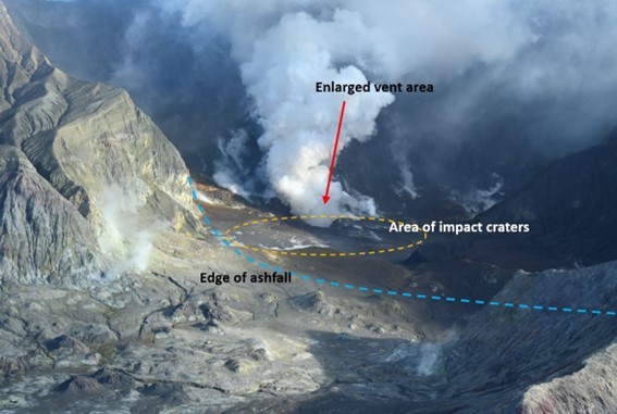
Interpreted image showing a plume of gas and steam emitting from the enlarged vent area (arrowed), the area where impact craters can be seen (orange dash) and the limits of the minor ashfall (blue dash). Image from 12 July 2024.
Volcanic gas emissions remain at moderate levels compared to what was recorded be-fore May but are now declining. The crater lake has dried up. Gas and steam are now exiting less vigorously from the enlarged vent on the crater floor. Steam and gas emissions are also occurring from several other vents that have existed for some time. No ash was observed in the plume during the flight on 18 July.
Although the Volcanic Alert Level remains at Level 2, eruptions can still occur with little or no warning as shown by short lived activity earlier this month. The Volcanic Alert Level reflects the current level of volcanic unrest or activity and is not a forecast of future activity. While Volcanic Alert Level 2 is mostly associated with volcanic unrest hazards (including discharge of steam and hot volcanic gases, earthquakes, landslides, and hydrothermal activity), the potential for eruption hazards remains.
As we have no sensors on the island, we continue to rely on remote cameras and satel-lite imagery, complemented with gas and observation flights to assess the volcanic activity. Further gas and observation flights will be conducted by GNS Science volcanologists to maintain a close eye on activity levels.
Source and photo : Geonet / Craig Miller / Duty Volcanologist