July 10 , 2024 .
Italy / Sicily , Etna :
WEEKLY BULLETIN, from July 1, 2024 to July 7, 2024. (issue date July 9, 2024)
SUMMARY STATEMENT OF ACTIVITY
In light of the monitoring data, it appears:
1) VOLCANOLOGICAL OBSERVATIONS: Degassing activity from the Bocca Nuova Crater and the South-East Crater. Strombolian activity and lava fountain events on July 4 and 7 in the Voragine crater. The Northeast crater continues to be obstructed, with weak fumarolic activity along the internal walls.
2) SISMOLOGY: Low-level fracturing seismicity. Volcanic tremors at high levels during lava fountaining episodes at the Voragine crater
3) INFRASOUND: Very strong infrasound activity during the lava fountains of the Voragine Crater.
4) GROUND DEFORMATIONS: During the last week of observation, the ground deformation monitoring networks recorded the variations produced by eruptive dynamics
from the Voragine crater.
5) GEOCHEMISTRY: SO2 flux at medium level
The CO2 flow is stable, at low values
The partial pressure of dissolved CO2 does not show significant variations
The helium isotopic ratio is high.
6) SATELLITE OBSERVATIONS: Thermal activity observed by satellite in the summit area was generally high to very high in correspondence with the lava fountains of July 4 and 6, 2024.
7) OTHER OBSERVATIONS: Drone surveys were carried out on July 5 and 8, 2024 to map the vulcanites and update the topography.
VOLCANOLOGICAL OBSERVATIONS
The monitoring of the volcanic activity of Etna, during the period in question, was carried out through various inspections in the summit area and through the analysis of images from the surveillance cameras of the INGV, Osservatorio Etneo (INGV-OE).
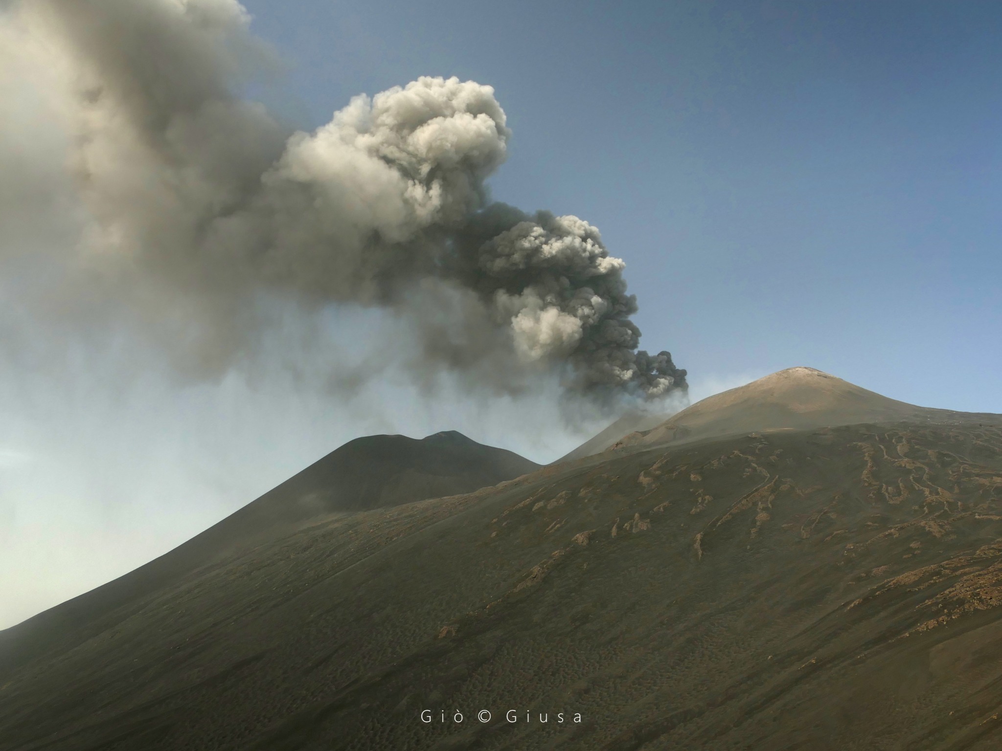
During the observation period, the degassing activity of the summit craters was mainly supported by the Bocca Nuova crater and secondarily by the Southeast crater. In particular, the degassing of the Bocca Nuova crater is characterized by a variable regime, sometimes impulsive, accompanied by episodic emissions of diluted reddish ash quickly dispersed in the summit area. Degassing from the Southeast crater is produced by a vast fumarolic zone in the eastern sector of the cone, by the pit crater on the northern edge of the crater and by the eastern vent. The Northeast crater is, however, only affected by weak fumarolic activity in an area of the northwest inner wall.
Regarding the Voragine crater, at the end of the morning of July 4, the Strombolian activity that began on June 13 and 14, which had slowly intensified over the following days, intensified considerably.
This activity was accompanied by the formation of two lava flows, started the previous days, produced by two vents located respectively on the South-East and North-West sides of the scoria cone inside the crater.
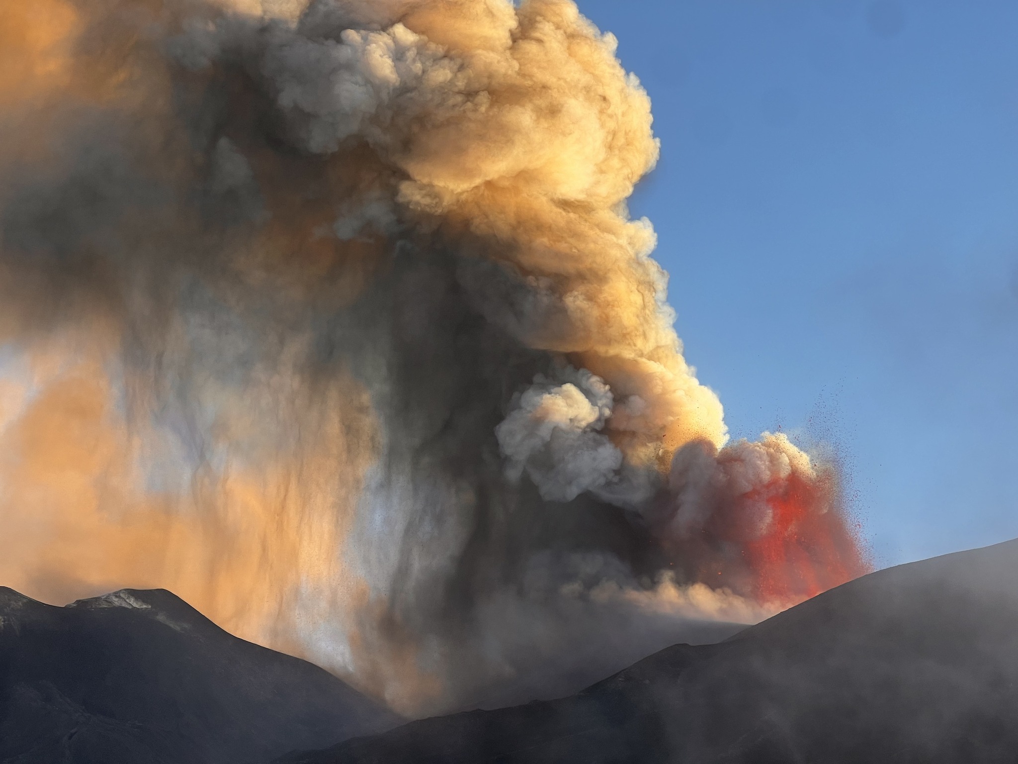
Beginning at approximately 16:15 UTC on July 4, Strombolian activity in the Voragine crater transformed into a lava fountain and produced an eruptive column that reached a height of approximately 4,500 m above the sea level and spread in a southeast direction, causing significant ash fall on various towns in the southeast area of Etna and as far as Syracuse and beyond. Lava fountain activity gradually weakened during the night of July 4–5, then ceased completely around 01:50 UTC on July 5. After the lava fountain ended, Strombolian activity continued for about an hour before ceasing completely.
On July 5 and 8, 2024, drone surveys were carried out to map the volcanics from the eruptive events of July 4 and 7, and update the topography of the summit craters. The surface covered by the additional flow of the crater is equal to 0.4 x 10⁵ m2 with a volume of approximately 1 x 10⁵ m3 (in red in Figure 3.1); the surface covered by the intra-crater flow is equal to 0.6 x 10⁵ m2 (in orange in Figure 3.1) finally the surface covered by the proximal pyroclastic deposit is equal to 0.8 x 10⁵ (in yellow in Figure 3.1 ). The altitude of the front was at 16:00 UTC on the 8th at 3016 m altitude (ellipsoidal quota).
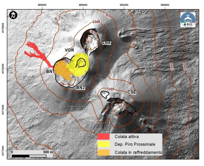
Map of the flows emitted during the paroxysms of July 4 and 7, 2024, superimposed on a shaded model of the terrain from drone surveys of July 5 and 8, 2024 and September 2023, superimposed on the shaded model from the Pléiades images of August 22, 2020. CSE = Southeast Crater, CNE = Northeast Crater, BN=Bocca Nuova, VOR= Voragine.
On the afternoon of July 6, there was a gradual resumption of Strombolian activity in the Voragine crater which, around 02:00 on July 7, transformed into a lava fountain, producing an eruptive column at approximately 9,000 m altitude, which spread eastwards, causing significant ash fall on several towns in the eastern area of Etna along the Zafferana Etnea – Giarre axis.
The activity also produced at 06:50 UTC, an overflow from the northwest rim of the Bocca Nuova crater, caused by the filling of the crater with the large quantity of pyroclastic material produced by the two paroxysmal events of July 4 and 7 of Voragine crater. The flow traveled a little over 500 meters from the edge of the Bocca Nuova, towards the Altomontana route and stopped a little less than 100 meters from the latter.
Lava fountain activity gradually faded and then ceased around 08:00 UTC on July 7. After the end of paroxysmal activity, Strombolian activity continued for about an hour, which also gradually weakened. In the last part of the paroxysmal episode, ash emissions were also observed from the Southeast crater and from the Voragine crater, which quickly dispersed in the atmosphere
Source : INGV
Photos : Guide Etna Nord – Compagnia Guide Etna , Gio Giusa , INGV.
Italy , Stromboli :
WEEKLY BULLETIN, from July 1, 2024 to July 7, 2024. (issue date July 9, 2024)
SUMMARY STATEMENT OF ACTIVITY
In light of the monitoring data, it appears:
VOLCANOLOGICAL OBSERVATIONS: During this period, intense eruptive activity was observed with splashes and overflows of lava from the northern area of the crater, lava flows coming from eruptive fractures of the Sciara del Fuoco, pyroclastic flows and landslides. The total hourly frequency of explosive activity until July 4 and then stopping with the start of effusive activity varied between average values (14 events/h) with an intensity of explosions that was low to medium level both in the North Crater Zone as well as that of the Center-South.
2) SISMOLOGY: Seismological parameters showed an increase in tremor amplitude in correspondence with the major event of 04/07 and a maximum peak around 17:00 UTC on 04/07.
The amplitude of explosion earthquakes and VLPs remained low.
3) GROUND DEFORMATIONS: The networks monitoring ground deformations on the island showed some variations linked to eruptive activity in the period considered.
4) GEOCHEMISTRY: SO2 flux at a high level
The CO2 flux in the summit zone is at average values.
The C/S ratio in the plume is at average values.
There are no updates to the helium isotope ratio in the thermal aquifer.
CO2 flow at Mofeta in the San Bartolo area: stable at high values.
CO2 flow in Scari: due to technical problems there are no updates
5) SATELLITE OBSERVATIONS: Thermal activity observed by satellite was generally at a high level.
VOLCANOLOGICAL OBSERVATIONS
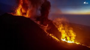
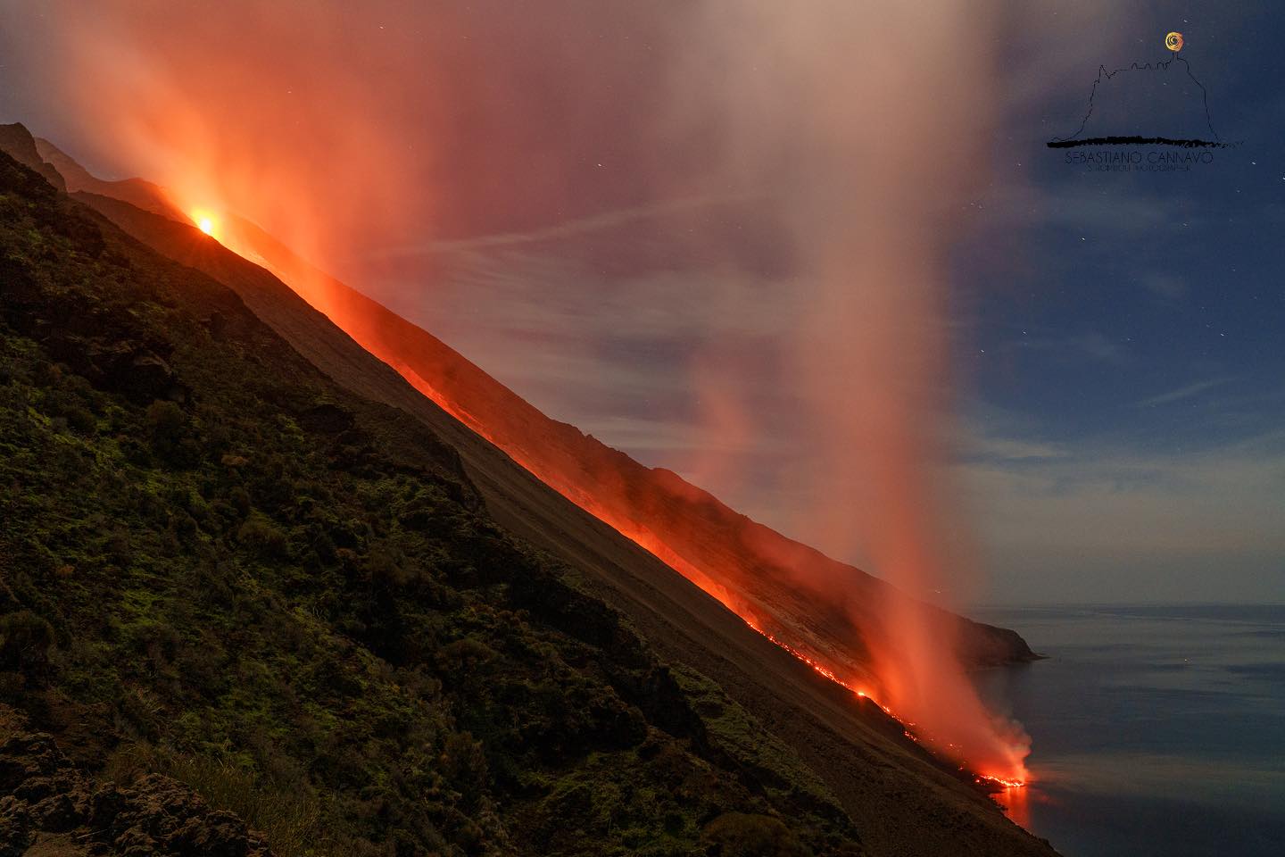
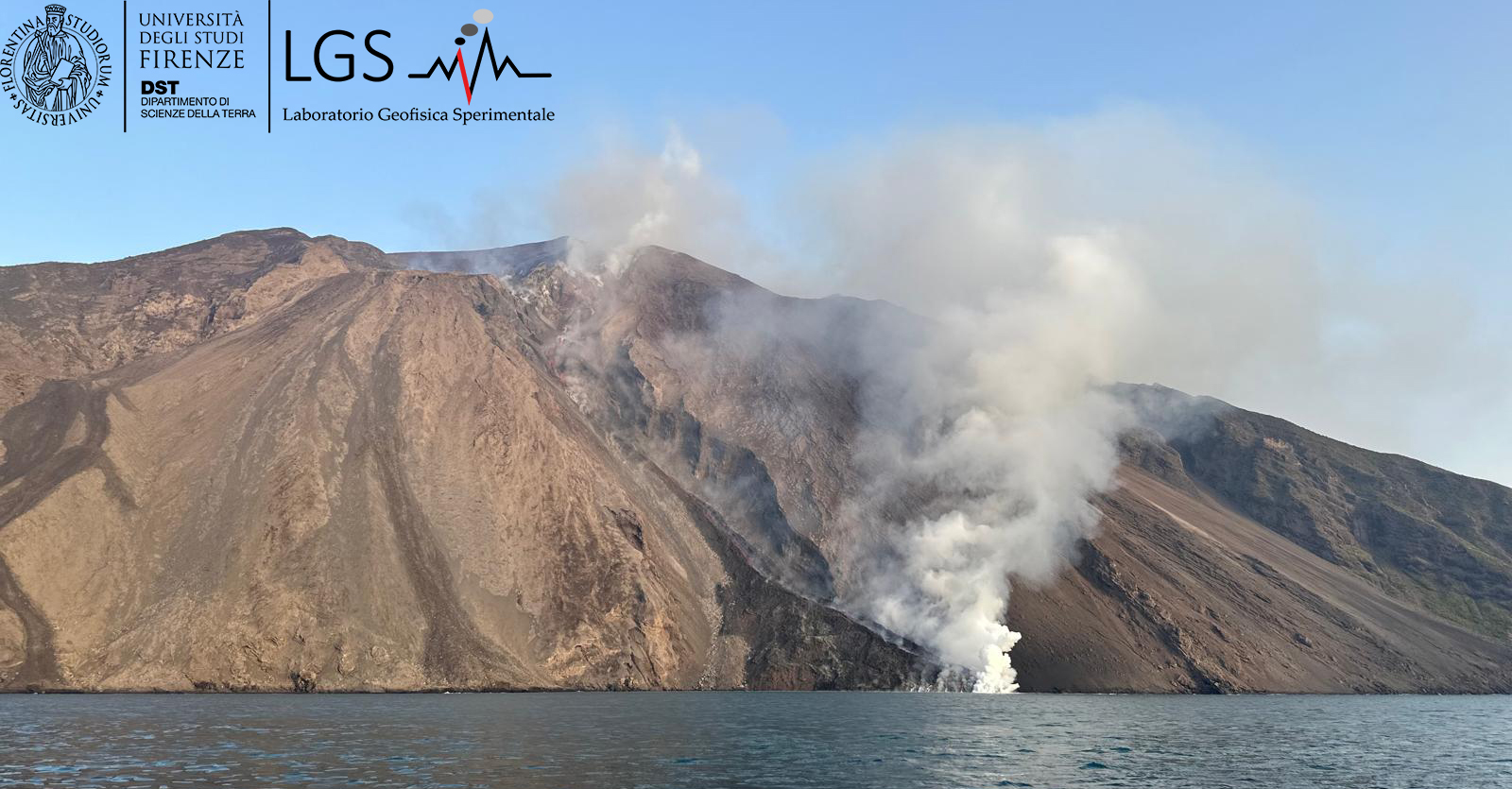
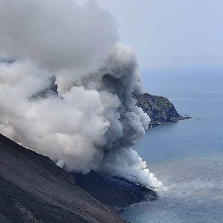
In the observed period, the eruptive activity of Stromboli was characterized through the analysis of images recorded by the INGV-OE surveillance cameras located at Pizzo (SPT), at altitude 190m (SCT-SCV) and at Punta dei Corvi (SPCT), as well as through field and remote observations from drones as part of the research activities carried out in the UNO and Dynamo projects, in the monitoring of Annex A and in the coordination of the Center of Wind Monitoring (CME). The activity until July was mainly produced by 3 (three) eruptive vents located in the northern area of the crater and by 2 (two) vents located in the South Central area. Since July 3, intense eruptive activity has been underway consisting of lava flows coupled with pyroclastic flows on July 4 with expansion along the Sciara del Fuoco and propagation into the sea over several hundred meters.
Observations of explosive activity captured by surveillance cameras
In the area of the North crater (N), with one vent located in sector N1 and one in sector N2, explosive activity was observed whose intensity varied from low (less than 80 m high) to medium (less 150 m high). Furthermore, projection activity was observed in both sectors, sometimes intense in sector N1 and which was at the origin of the lava overflow of July 3. The products emitted in the eruption were mainly coarse materials (bombs and lapilli). The average frequency of explosions fluctuated between 8 and 9 events/h. In the South-Central (CS) zone, sectors C and S1 showed no activity while in sector S2 the explosions were of varying intensity ranging from low (less than 80 m in height) to medium (less than 150 m height) emitting fine materials mixed with coarse materials. The average frequency of explosions varied between 4 and 5 events/h. The explosive activity gradually decreased until stopping during the day of July 3 in the Central-South zone and on July 4 in the North zone, coinciding with the start of the effusive activity.
Eruptive activity since July 3 and still ongoing (UTC times).
July 3 at ~4:35 p.m. at the height of intense projection activity in sector N1 of the northern zone of the crater, was followed at ~4:45 p.m. by the landslide of the outer part of the cone facing the Sciara del Fuoco . The phenomenon develops as a sequence of about 20 collapses of mainly cold material and a smaller part of hot material (part of the cone and lava) with fallout into the sea beyond the coastline. The fine materials produced by the landslide (ash) were carried by the winds and dispersed in the southern and eastern quadrants of the island. The phenomenon is followed at 5:02 p.m. by an overflow of lava coming from the same N1 vent in the North zone, coupled with splashing and explosive activity. The phenomenon continues throughout the night with lava fronts reaching an altitude of approximately 550-600 meters above sea level. By the early morning hours of July 4, the flow was no longer fed and cooling . The same day, July 4, from 2:10 p.m. preceded by a series of almost continuous landslides under the N2 of the northern zone, a new well-fed lava flow produced by an eruptive vent opened at the base of the cone of the North crater area at an altitude of 700 m above sea level. The flow propagates along the Sciara del Fuoco, and in particular towards the Bastion then along the Fuoco line. Subsequently, at 15:14 UTC a second lava flow begins which detaches from the first at an altitude of approx. 600-650 m, extending along the Sciara parallel to the previous one. At 3:47 p.m. the northernmost flow reaches the coast and flows into the sea.

At 4:15 p.m. following the sudden and rapid opening of a new effusive vent located at an altitude of approximately 510 m above sea level, a new lava flow followed with a high feeding rate and coupled with pyroclastic flows which spread rapidly on the Sciara del Fuoco, spreading over the sea for several hundred meters.
On the evening of July 4 and the night of July 5, the lava flow continued accompanied occasionally by pyroclastic flows. Between July 5 and 6, effusive activity shows stopping and restarting stages from the vent located at 510 m altitude with the opening of another vent at 485 m altitude in late morning of July 6. The effusive activity further intensifies during the night of July 6 to 7 with two flows produced by the two chimneys located at 510 and 485 m altitude which, when they converge, create a single lava flow reaching the coast, forming a lava delta. The lava flow, in contact with seawater, causes the formation of a cloud of steam. We can also observe the rolling of incandescent blocks of lava which, falling into the sea, cause small phreatic explosions and modest oscillations of the water surface. This last flow is the only one still fed.
Source : INGV
Photos : LGS , G. D’Astis , Stromboli stati d’animo / Sebastiano Cannavo.
New Zealand , White Island :
Volcanic Activity Bulletin
Wed Jul 10 2024 12:00 AM; Whakaari/White Island Volcano
Volcanic Alert Level remains at 2
Aviation Colour Code remains at Yellow
Since Wednesday 3rd July we have observed a more vigorous steam and gas plume rising from Whakaari / White Island. Calm and cool weather conditions offshore Bay of Plenty has allowed for very clear views of this activity for many from the coast. No clear eruptive activity has been observed at Whakaari/White Island since Saturday 25th May. The Volcanic Alert Level remains at Level 2 (moderate to heightened unrest) and the Aviation Colour Code remains Yellow.
When views are clear from our web camera in Whakatane, we often observe low level and weak steam and gas emissions from the island. These appear to have increased slightly since Wednesday last week and the plume appears hazier as the gas and vapour content increases. Cold air can help condense water vapour and make the plume look more obvious. Sunlight at different times of the day can also make the plume look different colours from white to grey to pale orange-brown. Satellite sensors have not detected sulphur dioxide gas or volcanic ash, and we have not seen any volcanic ash emissions in web camera images. Changes in the plume have been seen many times in the past and represent normal processes in the volcano like those happening since May as the lake and main crater area slowly dry out (see Volcanic Activity Bulletins 2024/04 and 2024/05).
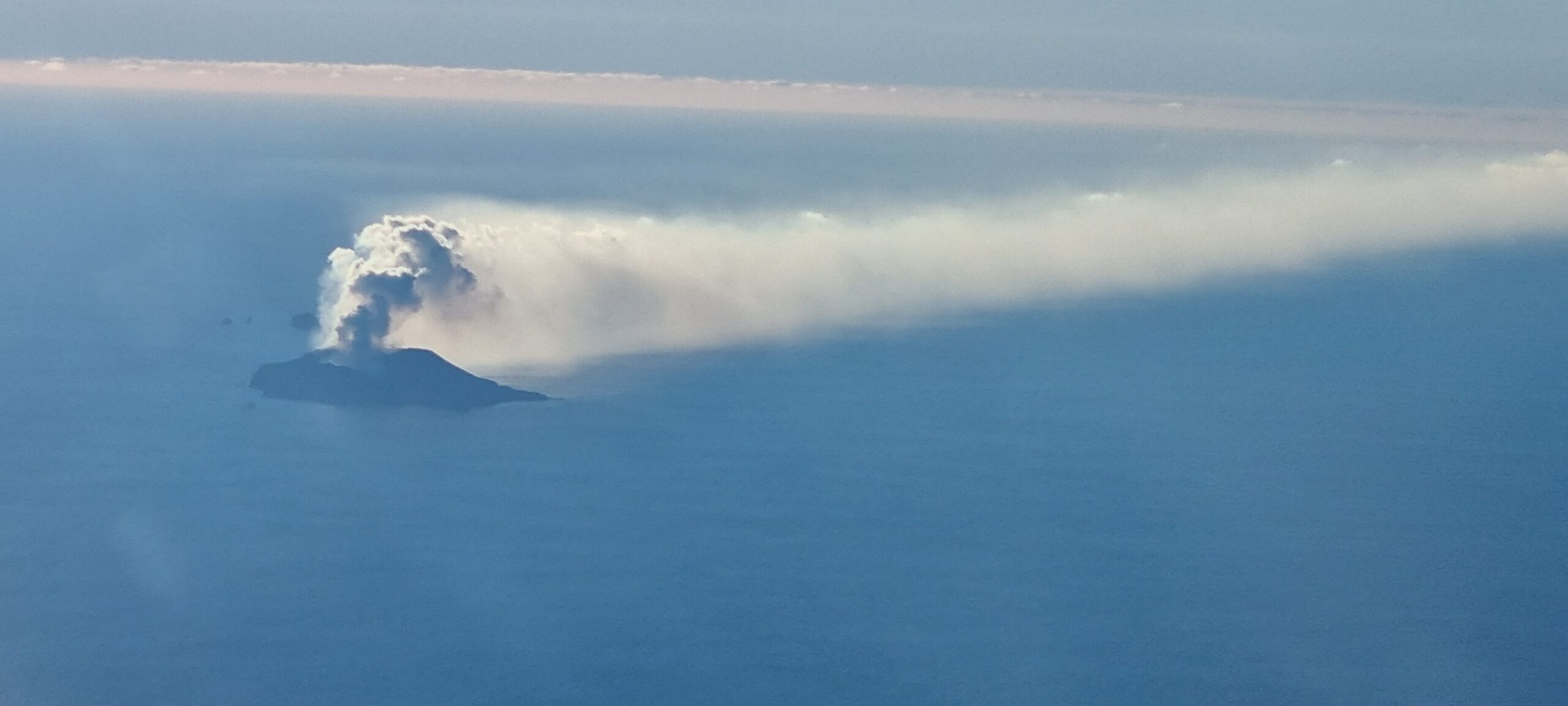
Figure 1. This image captured on Thursday (July 4th) shows the low-level plume of gas and vapour drifting eastwards from Whakaari/White Island,
Although the Volcanic Alert Level remains at Level 2, eruptions can still occur with little or no warning. The Volcanic Alert Level reflects the current level of volcanic unrest or activity and is not a forecast of future activity. While Volcanic Alert Level 2 is mostly associated with volcanic unrest hazards (including discharge of steam and hot volcanic gases, earthquakes, landslides, and hydrothermal activity), the potential for eruption hazards remains.
As we have no sensors on the island, we continue to rely on remote cameras and satellite imagery, complemented with gas and observation flights to assess the volcanic activity. Further gas and observation flights will be conducted by GNS Science volcanologists to maintain a close eye on activity levels.
Source : Geonet / Mike Rosenberg / Duty Volcanologist
Photo : Chris Clark
Iceland , Reykjanes Peninsula :
Constant land uprising under Svartsengi in recent days
Magma flow continues beneath Svartsengi. Probability of another magma flow and/or eruption in the coming weeks and months
Updated July 9 at 11:15 a.m.
Nearly 20 earthquakes have been recorded above the magma tunnel, the largest measuring 1.3 to the west of Grindavík.
More than 260 earthquakes were recorded on the Reykjanes Peninsula last week.
Deformation data shows land uplift continues at similar pace in recent days
Updated risk assessment. Almost unchanged, but the risk of lava flows has decreased.
Nearly 20 earthquakes have been recorded above the magma tunnel, the largest measuring 1.3 to the west of Grindavíkurbær. This is a similar activity to that of the last two weeks.
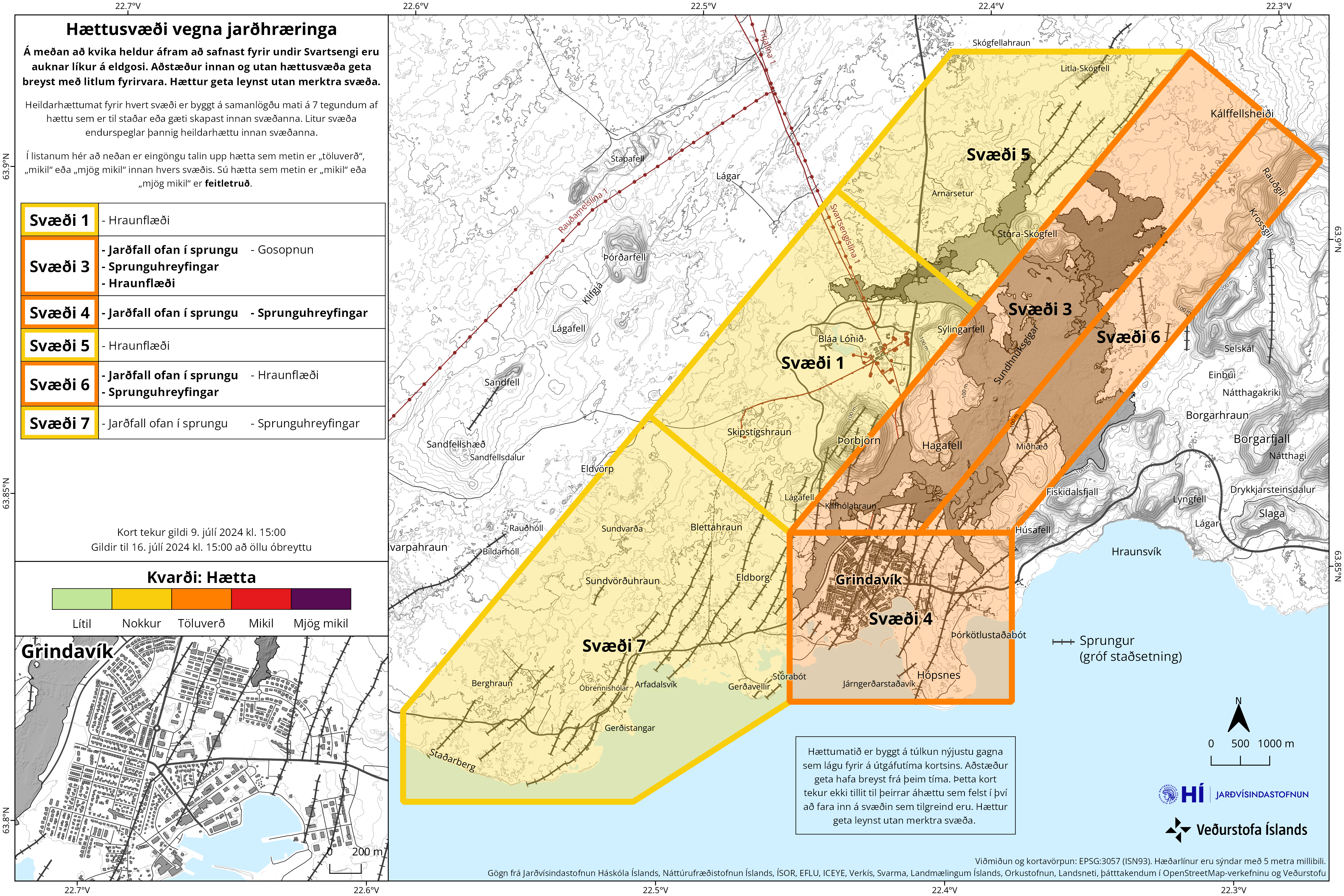
More than 260 earthquakes were recorded on the Reykjanes Peninsula last week. Around 60 earthquakes have been recorded in Lambafell in Þrengslum. About a dozen at Brennsteinsfjöll. More than 100 earthquakes have been measured around Kleifarvatn, more than 40 to the east of the lake and more than 60 to the west and southwest of the lake at and around the Seltún geothermal area. Just under 40 earthquakes have been recorded at Fagradalsfjall, all less than 1.0 magnitude and most at a depth of 7 to 10 km. Around 20 earthquakes were recorded outside Reykjanestá over the past week, as well as around a dozen earthquakes further afield in the Reykjaneshrygg region, about 90 km southwest of the country.
GPS deformation data shows that land expansion beneath Svartsengi continues and has occurred at a similar pace in recent days. A Sentinel 1 satellite image covering the period June 25 to July 7 shows the same pattern. Model calculations based on deformation data continue to indicate that magma influx is greater today than before the May 29 eruption. This data continues to indicate that another magma flow and/or eruption is likely in the coming weeks or months.
The risk assessment has been updated and remains valid until July 16. This remains virtually unchanged, except that in zone 1 (Svartsengi) there is less danger from lava flows. The risk is therefore reduced from considerable risk (orange) to moderate risk (yellow). The risk of lava flow is also considered lower in zone 6.
Source et photo : IMO
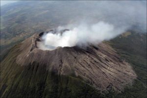
Indonesia , Dukono :
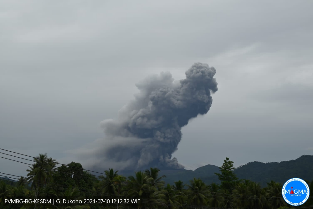
An eruption of Mount Dukono occurred on Wednesday, July 10, 2024 at 11:56 a.m. WIT with the height of the ash column observed at ±1,200 m above the summit (±2,287 m above the level of the sea). The ash column was observed to be white to gray in color with thick intensity, oriented towards the North-West. At the time of writing, the eruption was still ongoing.
Observation of seismicity
31 eruption earthquakes with an amplitude of 4 to 20 mm and a seismic duration of 31.41 to 61.93 seconds.
1 Local tectonic earthquake with an amplitude of 17 mm, the duration of the earthquake was 44.14 seconds.
4 deep tectonic earthquakes with an amplitude of 10-34 mm, and earthquake duration 76.32-90.12 seconds.
1 Continuous tremor with an amplitude of 0.5 to 6 mm, dominant value of 3 mm.
RECOMMENDATION
(1) People around Mount Dukono and visitors/tourists are advised not to do activities, climb or approach Malupang Warirang Crater within a 3 km radius.
(2) Considering that eruptions with volcanic ash occur periodically and the distribution of ash follows the direction and speed of the wind, so that the landing area of the ash is not fixed, it is recommended that the community around Mount Dukono still provides masks/nose masks. and mouth coverings to use when necessary to avoid the threat of volcanic ash to the respiratory system.
Source et photo : Magma Indonésie