July 5 , 2024.
Italy / Sicily , Etna :
Press release on the activity of Etna, July 4, 2024, 6:23 p.m. (4:23 p.m. UTC).
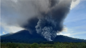
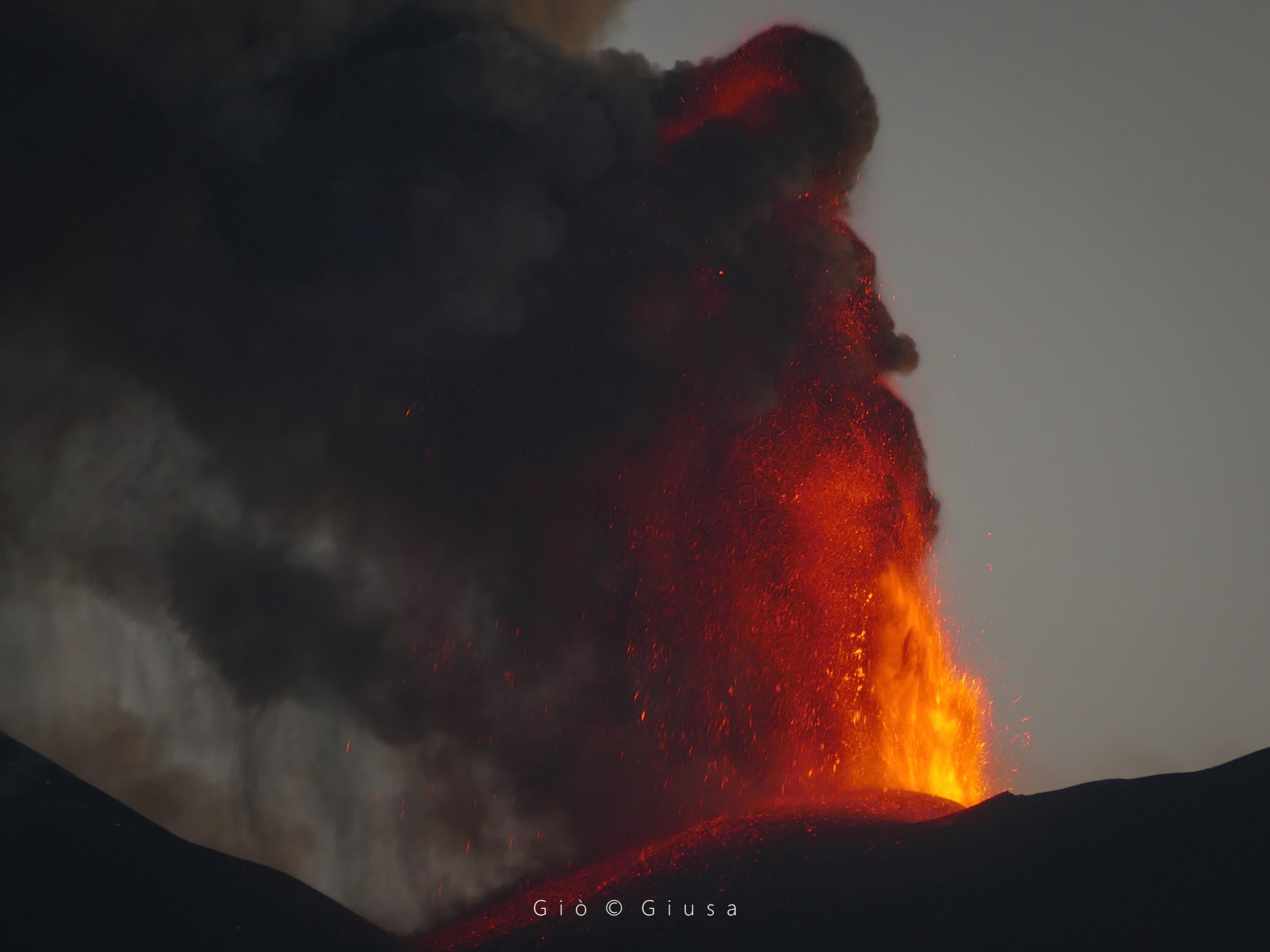
The National Institute of Geophysics and Volcanology, Osservatorio Etneo, communicates that, thanks to the network of surveillance cameras, the Strombolian activity in the Voragine crater has evolved into a lava fountain and produced a column that reaches a height of approximately 4,500 m above sea level and propagated in the southeast direction. Ash fall was also reported in several localities in the South-East of Etna and as far as Catania.
The average tremor amplitude, after reaching the maximum value around 2:30 p.m. UTC, underwent a sudden decrease until reaching the range of average values. Around 15:00 UTC a new phase of rapid increase brought the amplitude back to high values, where it still remains at very high values. The centroid of volcanic tremor sources continues to be located just east of the Voragine crater, at an altitude of approximately 2,900 m above sea level. Infrasound events have also experienced a rapid decrease from their frequency of appearance until their disappearance between 2:45 p.m. and 3:25 p.m. UTC. Subsequently, a resumption of activity characterized by infrasound events and tremors was observed. These are located at the level of the Voragine crater and the amplitude of the events is high.

The analysis of ground deformation data highlights a complex and rapidly evolving model. The inclinometer network highlights a first phase of deformation at the summit at 2:40 p.m. UTC, followed by a short phase of stability. The deformation resumes at 3:15 p.m. UTC, also involving a medium altitude station (Monte Denza) with a weak signal (less than 0.1 microradians); At present, the deformation at the summit station of the ECP (Piano Crater) has reached an amplitude greater than one microradian. The Monte Ruvolo dilatometer also shows a first phase of deformation, reported in the previous press release and which reached around 15 nanostrains, interrupted by a brief reversal at 2:35 p.m. UTC, with a subsequent resumption at 3:15 p.m. UTC. At the moment, this second phase has reached around 30 nanostrains.
The high-frequency GNSS network currently shows no distortion apart from background noise.
Further updates will be communicated shortly.
Source : INGV
Photos : Gio Giusa
Italy , Stromboli :
Press release on Stromboli activity, July 4, 2024, 6:48 p.m. (4:48 p.m. UTC).
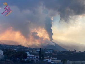
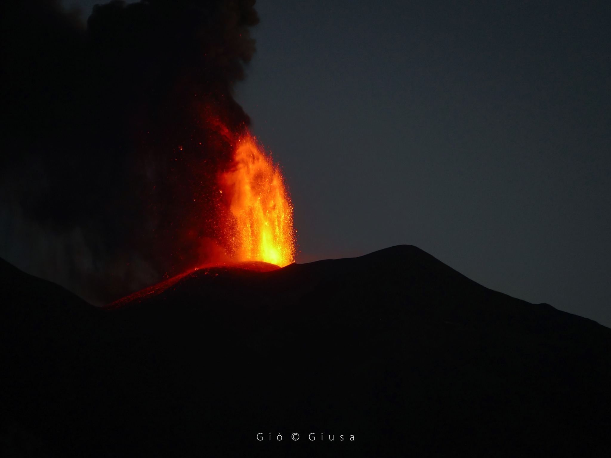
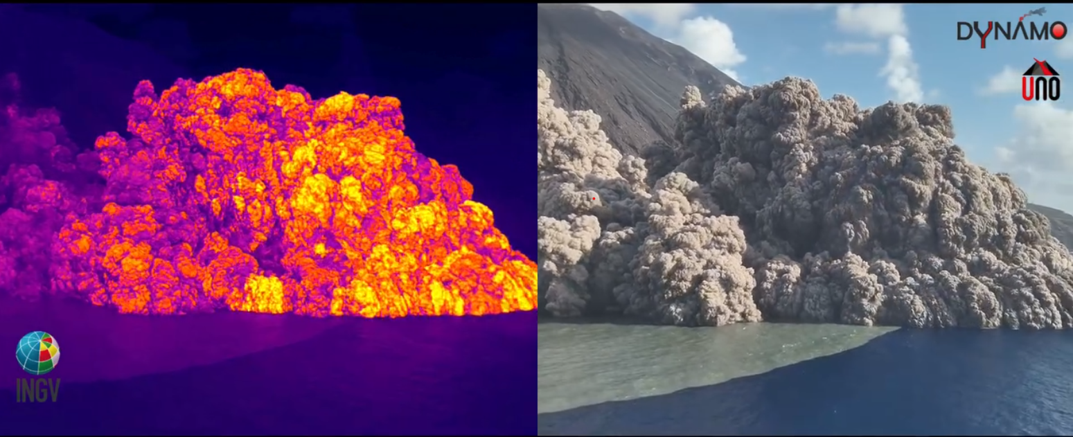
The National Institute of Geophysics and Volcanology, Osservatorio Etneo, communicates that at 16:18 UTC a pyroclastic flow occurred which developed rapidly along the Sciara del Fuoco, reaching the coast and propagating into the sea over several hundred meters. It is also possible to observe that the lava flow produced by the vent located at an altitude of 700 m and which propagates along the Sciara del Fuoco reached the coast around 3:30 p.m. UTC. The lava flow is still well fed. From the Sciara del Fuoco rises a column of ashes to a height of about 2000 m above sea level.
At 4:17 p.m., a sudden and notable increase in the amplitude of the seismic signal was observed, reaching a very high level at which it is currently maintained.
Analysis of ground deformation data shows a slight deformation of about half a microradian at the TDF station (Timpone del Fuoco) at 16:20 UTC. The high-frequency GNSS network appears to show a shift of about 5 cm to the southwest of the Timpone del Fuoco (STDF) station and a shift of more than 10 cm to the west at the Punta Lena (SPLN) station at 4:30 p.m. UTC; However, these movements must be confirmed by subsequent analyses, because they may be affected by errors due to the high quantity of ash in the atmosphere which disrupts the GNSS signal.
Press release on Stromboli activity, July 4, 2024, 8:40 p.m. (18:40 UTC).
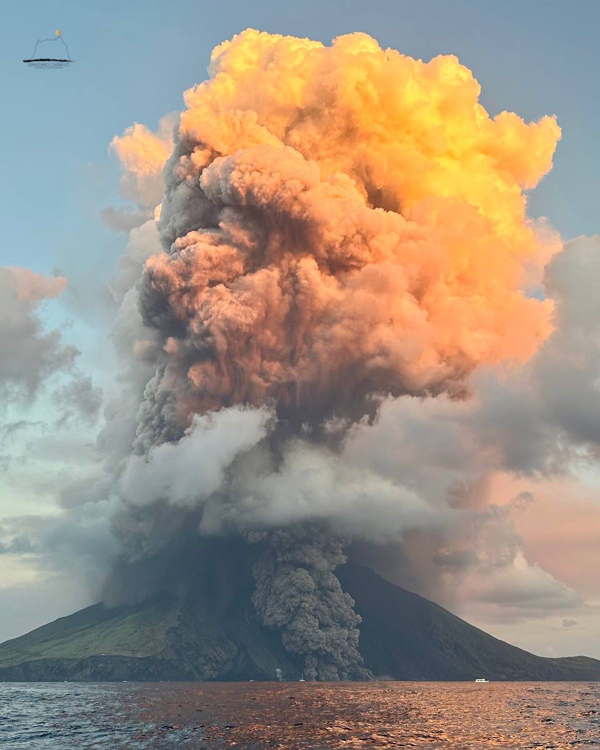
The National Institute of Geophysics and Volcanology, Osservatorio Etneo, communicates that after the pyroclastic flow of 16:18 UTC, many other flows occurred along the Sciara del Fuoco, the most important of which, at 18:10 UTC, occurred spread in the sea over several hundred meters. Effusive activity continues from the vent located at 700 m altitude, which appears to be well fed. From the Sciara del Fuoco, a column of ash continues to rise, reaching a height of around 2000 m above sea level.
After the increase in amplitude reported in the previous press release, the seismic signal remained at very high levels, although with some fluctuations. A maximum amplitude was recorded at 18:10 UTC at the pyroclastic flow described above.
From the analysis of the ground deformation, it appears that the centimetric displacements indicated in the previous press release at the stations of the high frequency GNSS network have largely disappeared; the residual effect of the ashes still present in the atmosphere and/or deposited on the antennas remains to be evaluated. The inclinometer signal from the Timpone del Fuoco (TDF) station is agitated from 16:20 UTC probably due to the vibrations induced on the sensor by the high level of tremor.
Further updates will be communicated shortly.
Source : INGV
Photos: Stromboli stati d’animo / Sebastiani Cannavo , INGV Capture d’écran .
Russia / Kuril Islands , Ebeko :
VOLCANO OBSERVATORY NOTICE FOR AVIATION (VONA)
Issued: July 5 , 2024
Volcano: Ebeko (CAVW #290380)
Current aviation colour code: ORANGE
Previous aviation colour code: orange
Source: KVERT
Notice Number: 2024-35
Volcano Location: N 50 deg 41 min E 156 deg 0 min
Area: Northern Kuriles, Russia
Summit Elevation: 1156 m (3791.68 ft)
Volcanic Activity Summary:
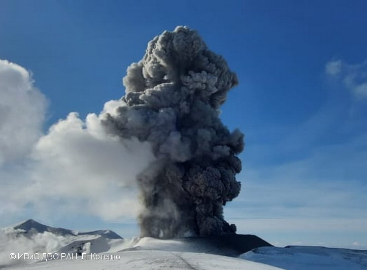
A moderate explosive eruption of the volcano continues. According to visual data from Severo-Kurilsk, explosion sent ash up to 2.5 km a.s.l., and ash cloud drifted to the north of the volcano.
A moderate explosive eruption of the volcano continues. Ash explosions up to 6 km (19,700 ft) a.s.l. could occur at any time. Ongoing activity could affect low-flying aircraft and airport of Severo-Kurilsk.
Volcanic cloud height:
2500 m (8200 ft) AMSL Time and method of ash plume/cloud height determination: 20240705/0200Z – Visual data
Other volcanic cloud information:
Distance of ash plume/cloud of the volcano: 3 km (2 mi)
Direction of drift of ash plume/cloud of the volcano: N
Time and method of ash plume/cloud determination: 20240705/0210Z – Visual data
Source : Kvert
Photo : L. Kotenko. IVS FEB RAS ( archive).
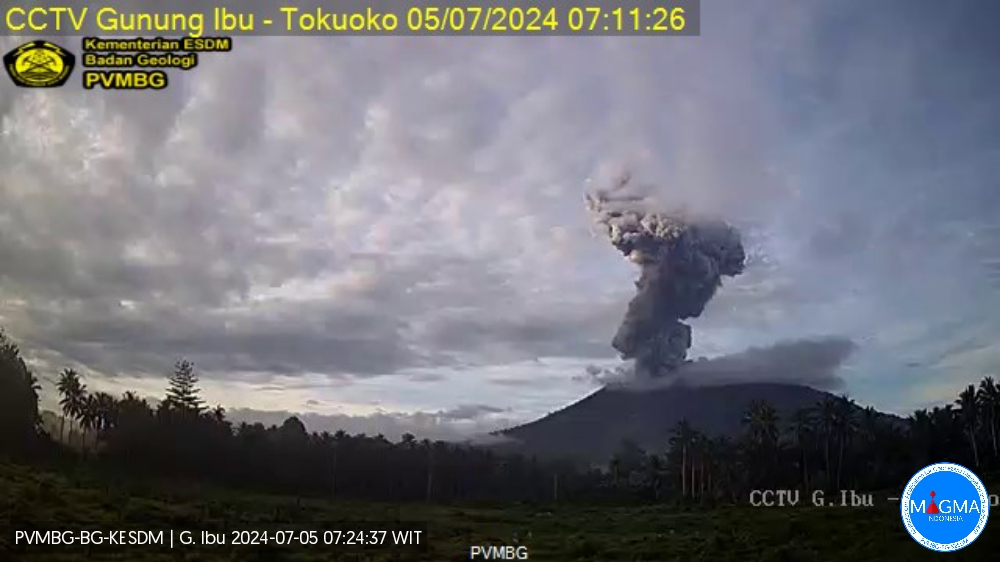
Indonesia , Ibu :
An eruption of Mount Ibu occurred on Friday July 4, 2024 at 07:09 WIT with the height of the ash column observed at ±3000 m above the summit (±4325 m above sea level). The ash column was observed to be gray to black in color with thick intensity, oriented towards the North and Northeast. This eruption was recorded on a seismograph with a maximum amplitude of 28 mm and a duration of 180 seconds.
VOLCANO OBSERVATORY NOTICE FOR AVIATION – VONA
Issued : July 04 , 2024
Volcano : Ibu (268030)
Current Aviation Colour Code : RED
Previous Aviation Colour Code : orange
Source : Ibu Volcano Observatory
Notice Number : 2024IBU048
Volcano Location : N 01 deg 29 min 17 sec E 127 deg 37 min 48 sec
Area : North Maluku, Indonesia
Summit Elevation : 4240 FT (1325 M)
Volcanic Activity Summary :
Eruption with volcanic ash cloud at 22h09 UTC (07h09 local).
Volcanic Cloud Height :
Best estimate of ash-cloud top is around 13840 FT (4325 M) above sea level or 9600 FT (3000 M) above summit. May be higher than what can be observed clearly. Source of height data: ground observer.
Other Volcanic Cloud Information :
Ash cloud moving to northeast. Volcanic ash is observed to be gray to dark. The intensity of volcanic ash is observed to be thick.
Remarks :
Eruption recorded on seismogram with maximum amplitude 28 mm and maximum duration 180 second.
Source et photo : Magma Indonésie.
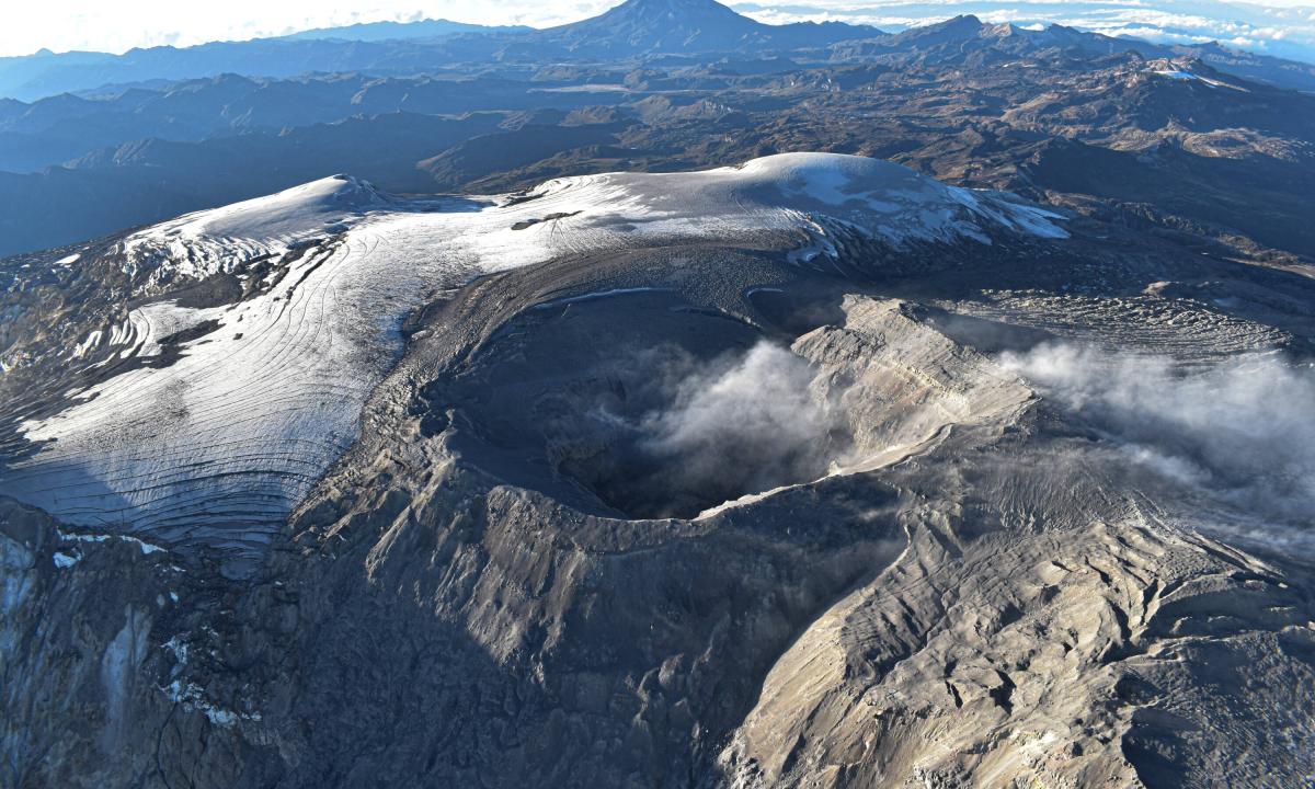
Colombia , Nevado del Ruiz :
Manizales, July 2, 2024, 4:30 p.m.
Weekly activity bulletin: Nevado del Ruiz Volcano
Regarding the monitoring of the activity of the NEVADO DEL RUIZ VOLCANO, the COLOMBIAN GEOLOGICAL SERVICE (SGC), an entity attached to the MINISTRY OF MINES AND ENERGY, reports that:
In the week of June 25 to July 2, 2024, the volcano continued with unstable behavior. Compared to the previous week, the main variations in the parameters monitored were:
– Seismic activity associated with the fracturing of rocks within the volcanic edifice has maintained similar levels in the number of earthquakes recorded and in the seismic energy released. The earthquakes were located mainly in the Arenas crater and, scatteredly, in the Northeast, Southwest and East sectors, at distances less than 12 km from the crater. The depths of the events varied between less than 1 and 9 km from the volcano summit. The highest magnitude of the week was 1.1, corresponding to the earthquake recorded on June 27 at 4:58 a.m. in the crater, 2 km deep. Seismic activity linked to the activity of the lava dome (protrusion or mound) located at the bottom of the crater decreased significantly during the week.
– Seismicity linked to fluid dynamics inside volcanic conduits has decreased in the number of earthquakes recorded and in the seismic energy released. The seismic signals showed variable energy levels with low to moderate values. Although to a lesser extent, the recording of long-period signals continued. Thanks to the cameras used to monitor the volcano, added to the reports of those responsible for the Los Nevados National Natural Park and residents of the area of influence of the volcano, it was possible to confirm several emissions of ash associated with some of these earthquakes. Additionally, temperature changes of the emitted material were confirmed using FLIR (thermographic) cameras.
– On the volcano, the emission of water vapor and gas into the atmosphere from the Arenas crater continues.
Sulfur dioxide (SO₂) outgassing rates were variable and continued to increase. The maximum height of the gas column, estimated above the summit of the volcano, was 1,400 vertically, on July 1, and at a dispersion of 2,100 m, on June 29. This last value was associated with the emission of ash recorded at 6:40 p.m. The direction of dispersion of the gas column was variable with a preferential trend towards the West of the volcano (from the North-West to the South-West).
– When monitoring surface activity from satellite monitoring platforms, the detection of thermal anomalies at the bottom of Arenas Crater continued to be limited by the heavy cloudiness conditions in the area. However, again this week, reports of detected anomalies were obtained, which presented low to moderate energy levels with slightly higher values than the previous week.
Source et photo : SGC